
SouthWake33
-
Posts
169 -
Joined
-
Last visited
Content Type
Profiles
Blogs
Forums
American Weather
Media Demo
Store
Gallery
Posts posted by SouthWake33
-
-
Heavier returns on radar heading toward wake county over next hour
.-
 3
3
-
-
Huh?
He said he had gone to New Bern
. -
Bigger flakes starting to mix in Cary
.-
1
-
-
Light snow in Cary near Lochmere
. -
Wrong!
If only we were all as smart as you!
.-
3
-
-
Co-worker is leaving Raleigh headed for a funeral in Illinois, by car, Friday morning at 6am. His route is up 77 through WVA and across Ohio. Looking at the models it seems he could drive through the storm. Any thoughts on what the sensible weather will be at that point? Flood risks? Wind threat?
.-
 3
3
-
-
We are down at bald head island through Monday. Keeping a close eye on this.
. -
Agree with all. Thanks for all your work this winter GaWx. I enjoyed your posts. I
-
 3
3
-
-
Roughly quarter inch hail in Cary near Trader Joe’s
-
2 hours ago, PantherJustin said:
not trying to be an ass.... but EYE no offense it was never a triangle thing anyway , and why lock the thread ? you can just not open it , certainly still a possibility for anyone along and W/NW of 77. I mean i get the discouragement but enough with this garbage man youre better than this
It’s been this way for a couple of years now. Use the block feature.
-
1
-
-
22 minutes ago, GaWx said:
The 18Z GFS has nothing wintry over the SE from either post frontal H5 disturbance. However, similar to the 12Z Euro, it does have from the 2nd disturbance a surface low that forms well offshore the SE coast. If there were to actually be a low that tracked, say, 200 miles west of that track, with about the same amount of cold air, there'd probably be a significant winter event 12/26-27 deep into the SE.
Keep in mind that this as well as the Euro low were generated by a disturbance currently 7,000 miles away from us and 4,000 miles off the Pacific NW coast where data is relatively limited and that isn't going to cross the Pacific coast for another 3 days. The pattern is quite complex with the huge Arctic high and another H5 disturbance ahead of this one by just one day. When considering all of this, a 200 mile west shift for something 5 days out isn't hard to fathom. So, though the odds favor no big deal 12/26-7 over the bulk of the SE from either disturbance based on model consensus continuing to keep it mainly quiet, a change to a big deal would not be the least bit shocking.
Really appreciate all of your updates! I continue to check in regularly. Hopefully things break our way soon.
-
2
-
1
-
-
Not that I trust the weather channel, but for Cary they are showing 1-3 inches of snow for Saturday night followed by up to an inch on Sunday with some sleet and freezing rain possible.
-
1
-
-
3 hours ago, msuwx said:
When you ae dealing with stream interaction/ phasing, the UKMET is usually one of the best.
We shall see.
Considering this endorsement of the UKMET and its most recent run I’m surprised there hasn’t been more discussion. Verbatim, the storm would be huge for most on this board! Rooting for a solution like this on future runs.
-
1
-
-
UKMET, CMC and GFS most recent runs all show snow for at least the eastern half of NC for Fri/Sat. 12z will be interesting.
-
1
-
-
2 minutes ago, Sandstorm94 said:
Eh...


Sent from my SM-S115DL using Tapatalk
Thank you. Will be interesting to see what the next few frames look like as it comes into range.
-
1
-
-
I know it’s a bit out of range, but how’s the NAM looking this morning?
Also, can someone post the CMC snow map, please? Don’t remember seeing it.
-
50 minutes ago, burgertime said:
Like this look for the south. Lots of energy rolling through and enough cold air. Even with the Euro solution from 12z it's a good look at this range. Split the difference and it's still a six inch snow storm! Can offer PBP for the Euro at 00z if it's looking good over the next few days.
My early weenie days were filled with PBP’s from burger and Robert. Great to have you on board for this one, burger!
-
7
-
-
29 minutes ago, nwohweather said:
Nice!
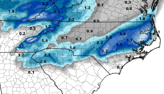
Looks interesting. What model and timeframe is this?
-
Surprised to wake up and see a winter weather advisory for Wake County. Calling for up to half inch of snow and light ice glaze.
-
Had flakes in Cary this afternoon.
-
A few wet snowflakes mixing in with rain in Cary
-
 1
1
-
-
2 minutes ago, frazdaddy said:
Wilksdude Burn's buddy
That’s it! Thanks
-
2 minutes ago, frazdaddy said:
He drops in from time to time.
Also, don’t think it was Brick that had the healing skies theory...can’t remember the user name, but he/she was an odd character.
-
7 minutes ago, Disc said:
Folks north of I-40 are sitting good right now. Mountains/foothills are gonna get a really good snow. VA/NC border should do really well too. Much uncertainty on the northern extend of the precip shield, but as climo suggest with such a track, areas even further north into VA will do well.
I see the 18z GFS is finally playing catch up too and showing snow into VA. Models will continue to adjust and I would not be surprised to see continued slight north trends for the next 24hrs. I have a hunch our snow totals will be going up overnight, but I will leave that to the overnight shift to decide and I can't 100% speak on behalf of them.
Thanks for dropping by Disc! Can you give any insights on the areas further east in NC toward the Triangle?
-
1
-
February 19-20 Major Winter Storm Threat
in Southeastern States
Posted
Congrats! Where are you located?
.