

wxmx
-
Posts
3,741 -
Joined
-
Last visited
Content Type
Profiles
Blogs
Forums
American Weather
Media Demo
Store
Gallery
Posts posted by wxmx
-
-
10 minutes ago, WxWatcher007 said:
How much rain have you had in the last few weeks?
About 16" or so ... most of it from Alberto (nearly 14")
-
 1
1
-
-
1 minute ago, Ed, snow and hurricane fan said:
It seems possible to me Jamaica might have actually helped slow down the weakening. Deeper convection appeared on the N side which might have been convergence aided. Trying to wrap around the entire eye or remnant eye.
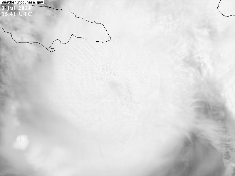
That crossed my mind, as a matter of fact. Right now very deep convection is trying to wrap around the eye.
-
 1
1
-
-
Some exorbitant rainfall amounts are modeled by the Ukmet and Euro close to my backyard (up to 30-40"). The CMC and GFS are closer to 10-12", which are still very high.
-
 2
2
-
-
9 minutes ago, Kevin Reilly said:
I will say that the center is definitely close enough for the circulation center to be disrupted by the high mountains of Jamaica.
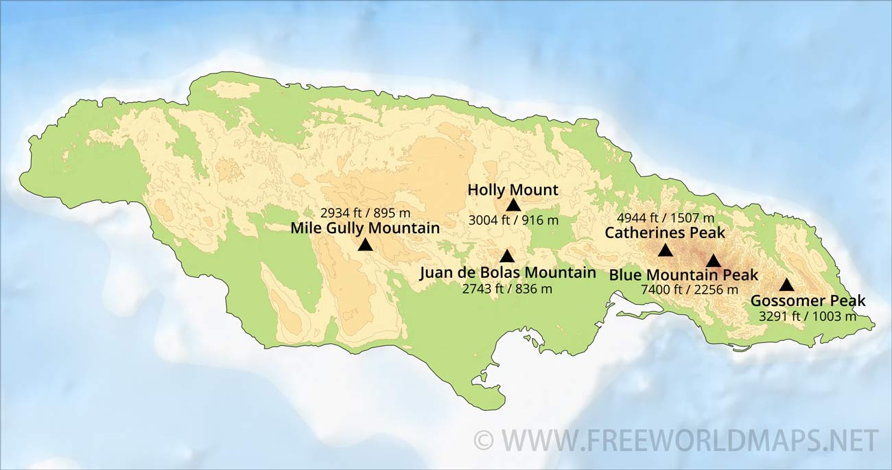
The highest mountains of Jamaica (~7000ft) are on the eastern end, and Beryl's core is already past them. The southern coast is not that rugged, and the highest elevations are closer to 3000ft

-
3
-
-
-
Euro is a bit north, between the Canadian and Ukmet, and a little south of the GFS...they are relatively tightly clustered. The main difference is that the GFS forages into S TX, the CMC rides the border, but the Euro and Ukmet stay on a WNW course farther inland into MX
-
Roll forward 3 months
QuoteModels are showing Hurricane Delta hitting the Tampico area, like the other 25 TCs this season
-
 2
2
-
-
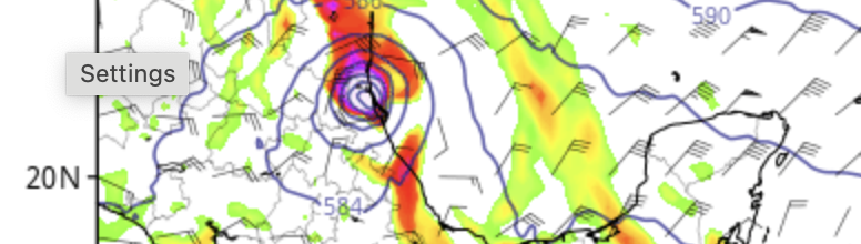
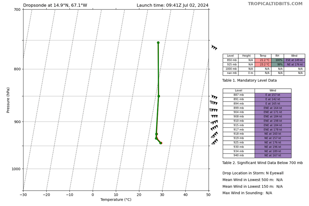
Intense connection in the northern eyewalk. Eye is trying to popup
-
46 minutes ago, Random Chaos said:
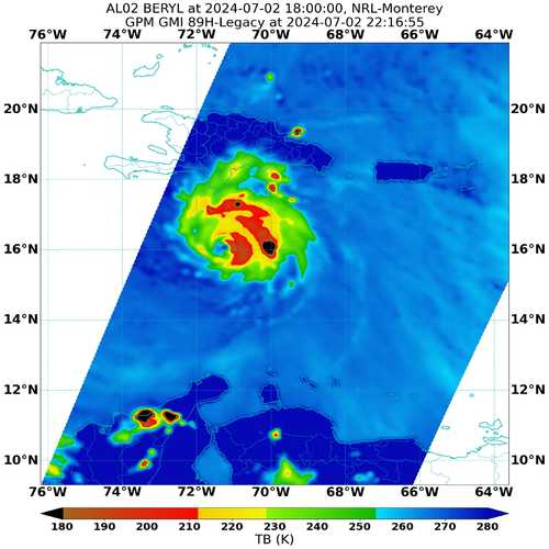
The core looks unhealthy in this 2 hour old SSMIS 85GHz microwave pass:
Most recent pass. The eyewall is opening to the W. Looks like the SW quad is getting the brunt of the shear.
-
3 minutes ago, g0ldl10n said:
I noticed that too on the HWRF run - HAFS-A isn't far off from that same look, interestingly.
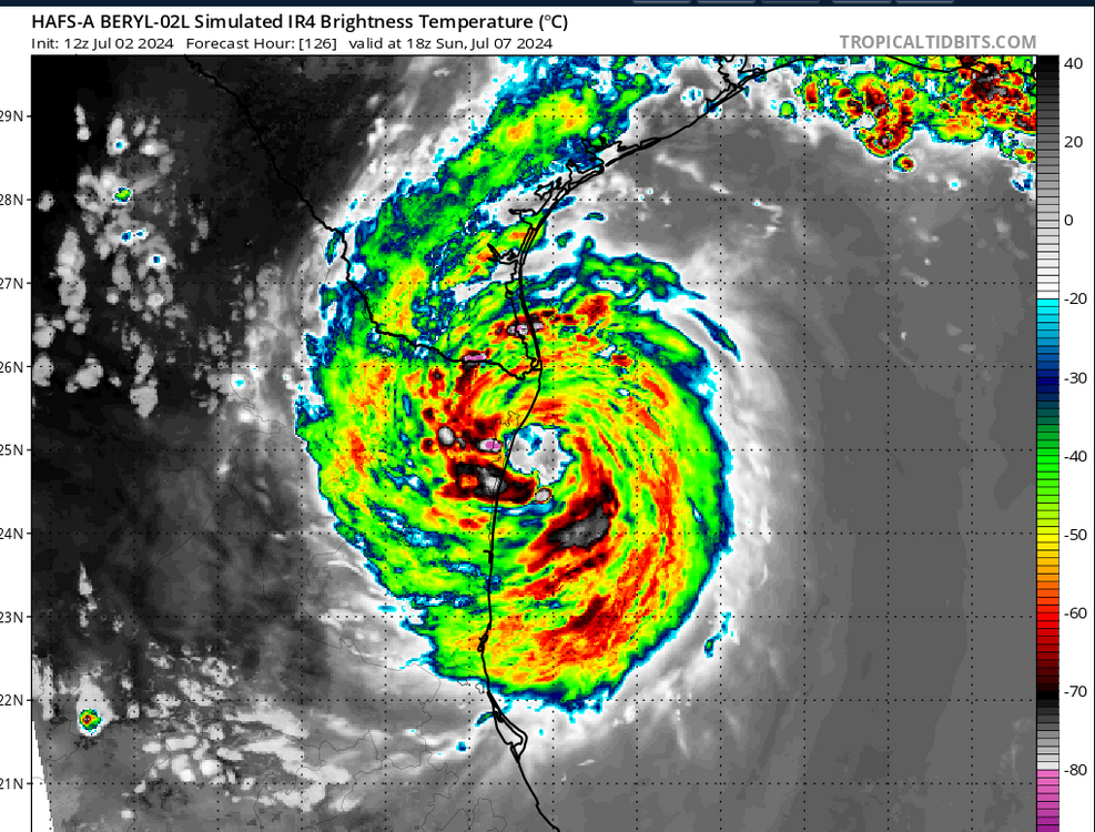
There's the scenario of a dirty EWRC, where the increase of shear and land interaction prevents a clean one, and also increments the size of the storm , as it spreads out the TS winds. Something like Ike, but in a smaller scale.
-
1
-
-
4 minutes ago, GaWx said:
12Z:
1) Euro and UKMET very similar in the vicinity of Tampico on S end
2) ICON TX/LA border on N end
3) in between are CMC halfway between Tampico and the TX border and the GFS at MX/TX border
4) Hurricane models relatively tightly clustered halfway between Tampico and the TX border.
Overall, consensus might be a tad south than 0z/06z, but not by much, mainly driven by the UKMET flip flop. Intensity wise, most models show a stronger Beryl, and hinting the GOM may have a somewhat conducive environment.-
1
-
-
Hurricane models 12z
HWRF: Stronger, solid cat 3 at Yucatan LF
HFS-A, HFS-B: Closer to each other, Tamaulipas LF. GOM looks conducive for strengthening. Cat 2 LF
HMON: Weaker, status quo during the GOM trek, Tamaulipas LF -
This is a few hours old. Beryl has likely peaked already and is probably starting an EWRC
-
1
-
-
8 minutes ago, Jebman said:
I am concerned for wxmx's safety should Beryl strike Mexico. This is an extremely dangerous hurricane.
Actually, the greater risk is for the Tampico area. I have seen this movie, multiple cyclones hitting near the Tampico area in a short period of time, with the Panuco and Tamesi basins over flooding, worst being 1933 and 1955. The rivers and lagoon system are already overflowing due to Alberto, PTC 2 and Chris, with the worst to come. If a Cat 2+ Beryl hits south or directly in Tampico, the Panuco river won't have a discharge channel due to the storm surge and a tragedy will ensue.
Ironically, the region was in it's worst recorded drought a couple weeks ago.-
3
-
1
-
-
IMO, higher than average confidence can be put on being a close call for Jamaica and that it will hit the Yucatan and enter the GOM. The second landfall after the Yucatan and the intensity during any of those landfalls are low confidence now.
-
1
-
-
Regarding the future track and intensity of Beryl, we have a couple big synoptic players, the SE US ridge and the TUTT extending from the SW Atlantic into the extreme NW Caribbean and west into the GOM. There's a secondary player, a through swinging through the Northern and Central Plains. The ridge and the plains through will mostly dictate the track, while the TUTT, and possible associated ULL, the intensity of Beryl.
It appears this hurricane season the SE Atlantic ridge will be anomalously strong, with throughs swinging through the CONUS at high latitudes, unable to weaken the ridge much, or maybe just dig far south enough to nearly collapse the steering currents while the cyclone is just too far south in the Bay of Campeche.
The TUTT on the other hand is trickier. It's forecasted to pinch off a ULL, but depending on the timing of this, and how far from the TC it sets up, it will either impart shear, or help ventilate the hurricane. The Euro is flip flopping on this, with the 0z and 12z imparting moderate shear, while the 06z sets the ULL farther to the NW, helping ventilate Beryl. So far, most models favor the shear scenario, but there's a caveat.
I'm usually not a fan of the 'hurricanes create their own environment' saying. Synoptic features like mid latitude ridges and throughs are just huge compared to tropical cyclones, so the effect of a TC is usually negligible. That being said, a big and intense TCs may factor in, specially on borderline scenarios, such as this one, where the timing of a ULL pinching off the TUTT and how far it positions itself from the cyclone.
A stronger, bigger TC, will have a huge outflow, aiding the ULAC expansion, which can assist to pinch off the ULL from the TUTT earlier, and push it a bit to the NW. Beryl is not that big, but it's not the compact storm it was 24 hours ago.
Anyway, that's some food for thought on Beryl's future.
-
9
-
5
-
-
It was CHRISTened. It's about to landfall.
-
Another case of "if it had a few more hours left out there". Huge drop in shear in just 3 hours
-
2
-
-
At least TD. A few 40+ FL, which with a 20% reduction would translate to roughly 35kts surface winds. That, plus many SFMR readings up to 50kts, may classify it as Chris prior to landfall
-
8 minutes ago, cptcatz said:
It's clearly north of due west. The current 5-hour satelite loop on TT shows the eye starting at 10.5 N and ends at 11 N. At the same time it went 1.5 degrees latitude. So the slope of the path is roughly 1/3. That track would miss Barbados and probably just south of the Saint Vincent island, bringing it through one of the small Grenadines islands.
Agree, it's clearly WNW (285 heading) now. Looks to miss Barbados to the south, but unconformably close. It's a compact storm, so the effects may be limited to TS sustained winds with possible hurricane gusts, torrential rain and a significant storm surge, but nothing catastrophic. But I would keep a wary eye, since deviating 70 miles to the North would make a big difference
-
2
-
-
1 hour ago, tiger_deF said:
Interesting cloud formation, resembles a wall of clouds separating the SAL to the North and the vorticity to the south
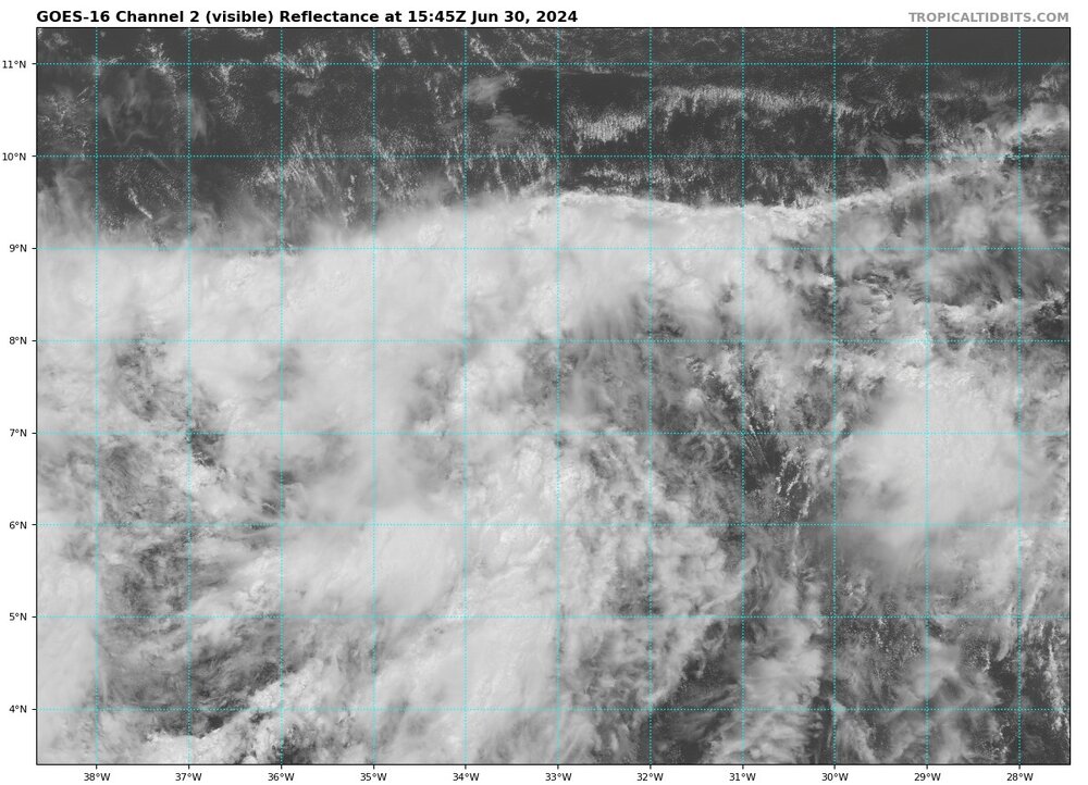
That's probably what it is. The "wall" of clouds are arc clouds formed when dry air entrain into the warm moist storms to the south
-
No FL winds so far supporting the surface winds, but it's clearly organizing on VIS. I think it will be upgraded to at least a TD, and since it's in an uptrend in organization it will gain the Chris name.
-
2
-
-
9 minutes ago, Ed, snow and hurricane fan said:
I don't trust anything showing an early July system strengthening in the Caribbean https://x.com/NbergWX/status/1806039356387271038
I mostly agree with you. Emily 2005 was definitely the definition of outlier, but it gave us a clear sign of what was to come. I wonder if this year we get that kind of signals.
-
2
-
-
19 minutes ago, CurlyHeadBarrett said:
Which model is this?
It's "just" the Euro model. I remember a GFS run back in 2007 that totally got Dean's track/timing/intensity right like 2 weeks in advance
-
1
-

Hurricane Beryl - Hurricane Warning - Baffin Bay to San Luis Pass Texas
in Tropical Headquarters
Posted
And it may be even strengthening a bit. IR showing warming eye.