

Jim Marusak
-
Posts
3,484 -
Joined
-
Last visited
Content Type
Profiles
Blogs
Forums
American Weather
Media Demo
Store
Gallery
Posts posted by Jim Marusak
-
-
could it be held up by the CI/AS layers currently in most of the metro from the storms off to the SW near Brownwood/Abilene/Dyess AFB (extrapolating from the ASOS cloud heights and satellite pics there attm). it also looks like two sets of the blowoff tops may have caused a bit of a bubble to form in between, with that bubble right on top of the metroplex.
-
on the SPC site, just saw the 00Z soundings at OUN and FWD, and those look a lot more promising now for all modes of severe weather with a bit of a more stereotypical severe weather lid forming aloft. add to that the height falls now coming in from NM with an approaching upper low on the mid-level WV satellite (channel 9), and now we're going to get to business for eastern OK and beyond, imho. the high risk may end up verifying yet, or at least has a better chance now. just a more dangerous setting in the night.
-
Just now, zinski1990 said:
Give it up folks. It's a bust. It's all over. It's just a crap line now
i'm not calling it a bust by any means. was it in the storm mode everyone was hoping for in the OKC metro and SE OK? no, too tropical below 650 in the warm sector. but Jackstraw is right in that we're getting to the time in the evening and into the night where the near-surface layer isn't as important and the LLJ kicks in. And from that 21Z sounding I pointed out earlier for OUN, there's still enough kinematics and instability aloft to do a lot. It will be interesting to see the 00Z soundings from OUN, MAF, and FWD as well as any special soundings if they were to put them up out at ABI and maybe SPS to get a better pic of the air masses moving in for the overnight.
-
 1
1
-
-
3 minutes ago, Misstertwister said:
Where’s the boundary? Me thinks NW OK?edmond area is north of the boundary. It’s fricking cold out when I took my dogs for a walk in Deer creek
going based off the obs, I would say Swisher County Tx > Altus OK > Minco OK > downtown OKC > Cushing OK > Nowata Conty OK with a first guess
-
anyone look at the 21Z sounding from OUN (18Z and 21Z sounding pages linked below)? If you did, maybe you could see what's actually the problem in the OKC metro and SE OK attm. it actually looks like the moisture may have been way too deep to really get anything explosive going. very moist sounding from the surface to 650hPa. A lot of CAPE there, but the lower 1/3 of the troposphere almost looks purely tropical, IMHO. And tropical air masses aren't as tornado-prone as more traditional storm soundings. Not saying we won't get massive downpours with that, because we most certainly are, and will see that. And not saying that you can't get anything rotating with it, because we are seeing it in spots. But normal tornadic air masses with the normal V at the bottom this is not.
https://www.spc.noaa.gov/exper/soundings/19052021_OBS/
https://www.spc.noaa.gov/exper/soundings/19052018_OBS/
something closer to traditional would be the sounding at KAMA at 19Z, if you mix out the surface.
https://www.spc.noaa.gov/exper/soundings/19052019_OBS/
thoughts on this observation?
-
3
-
-
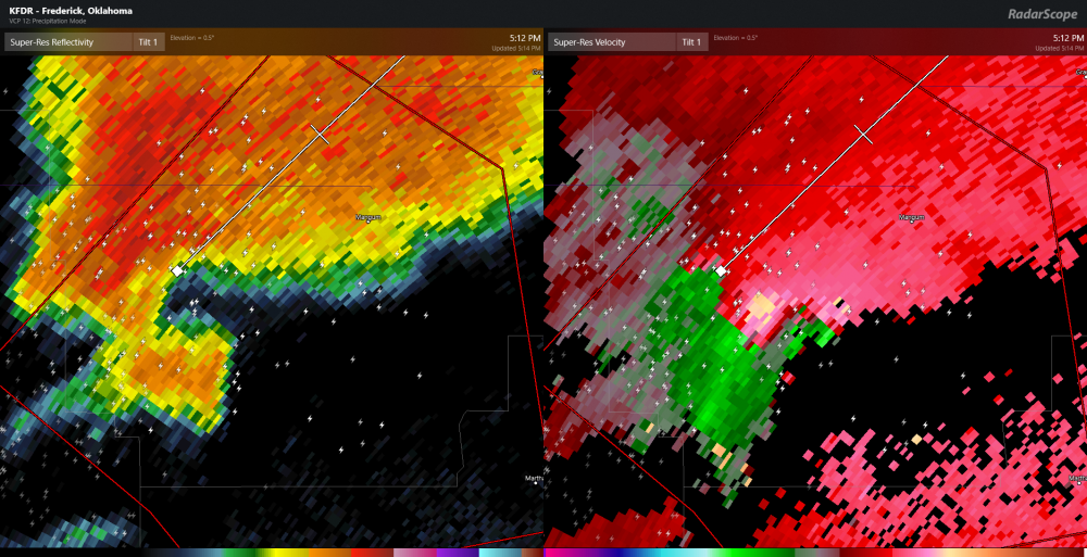
better look reflectivity and velocity from KFDR radar, tornado now on the ground, Mangum, OK.
-
a friend of mine over near Shickshinny Lake in rural Luzerne County PA actually posted a pic up of hail near ping pong ball sized hail with the cluster that moved through Luzerne County near 8p EDT, with a bunch of quarter-sized still in the yard after 20+ minutes of melting time.
Also, in the City of Nanticoke on the other side of the river, I saw a bunch of friends who put up pics of tree damage (some pretty big and healthy ones) from the first cluster of storms a couple of hours earlier, with power out in several sections of the city.
hopefully they all took my instruction and reported the pics and the hail/damage to the NWS in BInghamton, but we'll see in the final records.
the radar was actually looking decently impressive by eastern PA standards this afternoon.
-
2 minutes ago, yoda said:
Another confirmed tornado in NE by spotters
BULLETIN - EAS ACTIVATION REQUESTED
Tornado Warning
National Weather Service North Platte NE
815 PM CDT Fri May 17 2019

The National Weather Service in North Platte has issued a

* Tornado Warning for...
  Southeastern Custer County in central Nebraska...

* Until 900 PM CDT.

* At 814 PM CDT, a confirmed tornado was located 8 miles south of
  Oconto, or 17 miles north of Lexington, moving northeast at 25 mph.

  HAZARD...Damaging tornado and tennis ball size hail.

  SOURCE...Weather spotters confirmed tornado.

  IMPACT...Flying debris will be dangerous to those caught without
           shelter. Mobile homes will be damaged or destroyed.
           Damage to roofs, windows, and vehicles will occur.  Tree
           damage is likely.

* The tornado will be near...
  Oconto around 835 PM CDT.

Other locations impacted by this tornadic thunderstorm include Burr
Oak, Buckeye, Lodi, Pressey State Wildlife Management Area,
Intersection of Highway 183 and Cumro Road and Cumro.

This includes the following highways...
 Highway 183 between mile markers 74 and 93.
 Highway 2 between mile markers 280 and 300.
 Highway 92 between mile markers 300 and 302.

PRECAUTIONARY/PREPAREDNESS ACTIONS...

To repeat, a tornado is on the ground. TAKE COVER NOW! Move to a
basement or an interior room on the lowest floor of a sturdy
building. Avoid windows. If you are outdoors, in a mobile home, or in
a vehicle, move to the closest substantial shelter and protect
yourself from flying debris.
that's the same cell that has been going from McCook to Cozad, that's just a "hand-off" warning for North Platte as the cell moves across CWA's.
-
 1
1
-
-
1 minute ago, yoda said:
Spotters reported large and dangerous tornado 1 mile N of Cozad in Nebraska
and Cozad is about to get hit with another circulation, and possibly a 2nd tornado. not exactly their night for viewing only.
-
Just now, Indystorm said:
Noticed this as well and thought it was a result of merging supercells.
at least I'm not the only one. because yea, you're right they're usually the result of cell mergers and are short-lasting due to outflow disruption, allowing for one dominant cell and circulation to take over. these cells being the formation they are just seem unusual to me. I wonder what type of data the researchers are getting out there today on those cells.
-
question here. maybe i just haven't seen enough of them due to work or something. but there seem to be more than the usual amount of "multi-core" or "multi-circulation" supercells today than usual. the one that formed near Ft Stockton and is still going to the east on I-10, and the one currently in Nebraska crossing I-80/US 30 between Gothenburg and Lexington. the ones I have seen the most are usually single core-single circulation. is it just me?
-
one curious thing, looking from the Hastings radar. you have one storm just departing the 88d near Goodland, and one moving on top of the LNX/LBF radar near Thedford. both getting direct hits within minutes of each other. good thing they're engineered well. would hate to see the areas west of US go low-level radar blind from both radars at once
-
twin cities bet payouts would most likely look like the following for this system, at least according to how I see it...
- > 4" pays
- > 6" pays
- > 8" , 3-2
- >10" , 7-2
the heaviest part of the snow falls 7a-1p (13Z-19Z). but I don't like some of the messaging up here with several of the TV mets splitting the snow 1/2 morning and 1/2 afternoon, not say a 2/3 - 1/3 type of split, which is looking like the much more probable scenario up here. hope some of the messaging changes soon up here.
-
so, given what is being seen so far, what tweaks would everyone like to make to the FV3 to help it along to get better in North America and beyond?
-
Just now, Voyager said:
Thanks Jim. I was wondering if the elevations we're high enough for such a situation. I know that at times the cold air drains into the valleys such that Hazleton can be as much as 10-15 degrees warmer than where I live in Tamaqua.
they are not tall enough to be anything like the rockies or even the Smoky Mountains. But they are just tall enough to be a total PITA when it comes to forecasting. And also, I got that insight one day after I talked to my older brother after he drove to and from Tobyhanna and reported as such when he ascended from Nanticoke to I-81 to I-380 and the sleet/snow to freezing rain/rain change happened near Gouldsboro on i-380. Checked an analysis model sounding after the fact, and that actually confirmed that thought.
-
16 minutes ago, Voyager said:
What's with the "hole" over the Poconos? I've seen that a few times on various models this week.
i've seen the reality of this before, and the models may now be picking this up in the highest resolutions. when you're talking elevations in northeast PA, you have the cities at the valley floor of the Susquehanna at ~ 450ft MSL (~145m), which translates to ~14hPa from Sea Level Pressure using normal assumptions. but when we talk most of the towns in the Poconos, we're talking most crevices at ~1300-1400ft msl (400-430m) which translates to ~40-43hPa, with the mountain tops between 1900-2300ft msl (580-700m), which can be ~58-70hPa. if you look at most sounding profiles carefully in an over-running situation like we are looking at and then look at the real temperatures, you'll actually be warmer say in Hazleton or Mount Pocono than you would at Avoca or Wilkes Barre because the warm layer aloft in that small distance doesn't change height much, but the column in which the air can cool back down is a lot shallower at ~925 or 935 hPa in Hazleton or Tobyhanna than it would be going all the way down to ~980-990 hPa in downtown Wilkes Barre, Pittston, or Mocanaqua. As a result, you'll more likely see sleet in the valley near US 11 but head up the mountain on PA 93, I-81, PA 115, PA 309, or I-380; and you're more likely to see it be freezing rain in say Hazleton, Mount Pocono, Bear Creek near the Turnpike, or Tobyhanna because the melted water is cool enough to be super-cooled but not enough to turn all the way to sleet/ice pellets (just a few J short).
So the models, when displaying snow/sleet accumulations, might be picking up on that fact and adjusting amounts accordingly.
-
i have to get to bed in a little bit with work in the morning. but one thing that I am noting with some of the storm tracks and what the model profiles are showing. you may want to keep an eye on the cPk air mass up in Quebec. something about this setup is starting to look a bit like Valentine's Day 2007. but I am hoping the trend is slowly south. Otherwise, you may want to start thinking of staying off I-78 between the Lehigh Valley and Ft Indiantown Gap during this storm.
-
4 minutes ago, pawatch said:
Thanks Jim for sharing your thoughts! Tonight it appears the Nam & the GFS are drinking the same Koolaid .
actually, the GFS seemed to be the outlier after the 18Z runs, and the 00Z seems to also be there. The 12Z Euro, at least from weather.us, shows a similar precip type pattern to the 00Z NAM, albeit a bit further south than the NAM. at least to me, the GFS is the one that is drinking some rather nasty spiked kool aid, and should be discounted. even the 12Z GGem was starting to come towards being inline with the euro.
-
2
-
-
looking at model trends the last couple of days, and now the 00z nam, I have to admit, the all snow/snow ice line model trend i think is starting to settle in somewhere from about I-84 near Port Jervis to the Wyoming Valley, State College, Latrobe, and Washington PA. but given past storms, I wouldn't be surprised if it sinks a bit further south. but the weaker system moving through Friday looks like it will set the tone where that snow/mix line sets up.
-
This is something I have thought about a bit off and on for the last few months, but the discussion came to a head in my head today while in church. But also it was something that came up over the last few months while helping a friend who's a salesperson at outdoor markets and having to not only clarify what she saw on forecasts from different wx apps, but also when she got the final word from me, when I had to explain it all, even though they could have been summarized in some much simpler wording she can relate to.
one of the problems we have in the US when it comes to things like forecasts, imho, especially on phones and everything, is how we as mets rely more on those devices on numerical pops to convey the point of what is going on. Only problem with the pops, especially as they drastically shift from every major model run every 6 hours to the next. And unless you're a math whiz, a fellow met, an EM person, or a poker player, more often than not you can't really envision pops like we know they should be interpreted.
what if we in the weather enterprise stopped using numerical pops in forecasts to the public at large (including on cell phone forecasts and on TV), going with word choices to actually describe the situation? mind you the pops should still be available as a side link, especially for those in the EM and risk management side of the field, as they would more properly be able to use those numbers for assessment purposes. but in my experience at the plant, even with the safety managers, is that choosing your words properly to describe a situation gets the message though to the public more than a numerical pop does.
I know on cell phone weather apps that would present more than a few headaches in using the pop numbers to created a completely worded forecast, especially on an "hour by hour" basis. But if they potentially make people more prepared for inclement weather, would it be worth the hassle for the change?
-
My home town of Nanticoke, PA got hammered from straight-line winds, from what I am seeing from friends and such on FB. Damaged roofs, trees broken and even a few uprooted (some pretty big ones too, like a couple of feet across), power out in several places, just a total mess.
-
8 minutes ago, Crazy4Wx said:
This may be a dumb question, but is there a reason why we don't launch a drone from the Hurricane Hunters inside the eye to provide real-time data?
have to admit, i'm not totally up on the latest in high end military drone tech. But i'm not sure we have a drone in our arsenal or in existence that can actually mechanically take the turbulent stresses that major hurricanes near mountains can deliver. if we do, it must be like an x-class experimental plane or something like that.
-
yea, that is a nice hook down near there, but it sort of devolved a bit as it moves south of Carta Valley.
As for the storms near Waco, the most interesting velocity signature there is in between Meridian, Whitney, and Clifton.
-
17 minutes ago, janetjanet998 said:
low-mid 60's dew points on the SE side of the metroplex at 22z
I suspect the game might have a few lightning delays after the half
7 minutes ago, Jim Marusak said:i thought AT&T stadium was a domed stadium.
6 minutes ago, janetjanet998 said:oh yeah LOL....what was i thinking
that all being said, I have to admit having that line on US 281 from Mineral Wells to Lampasas looks awfully ominous for i-35 eventually, and the t-storm in Mansfield may make things interesting at the stadium in the next 15-30 mins.

June 13-30 Severe weather
in Central/Western States
Posted
00Z RAOB from FWD. just an ever so slight lid still holding attm, especially if you look at the mixed layer, not the pure surface Td. still though 3900 j/kg cape and an LI of -12. just need to bust the cap at 750hPa. the lapse rate from the lid to 500hPa is big though, so pop it, and you'll need more than the Coyote's parasol to protect you from the hail.