

snowman21
-
Posts
4,529 -
Joined
Content Type
Profiles
Blogs
Forums
American Weather
Media Demo
Store
Gallery
Posts posted by snowman21
-
-
Just now, CT Rain said:
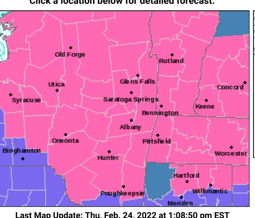
Yeah the map has warning criteria snow for one town. They never normally issue warnings for the whole county when that happens so idk what that's all about.
It's just a watch, so my guess is they see part of the county already in range and any slight shift of that eastward would qualify the entire county when it comes time to pull the trigger on a warning. If it doesn't then they just convert to an advisory. Seems like giving themselves wiggle room.
-
9 minutes ago, ORH_wxman said:
Lol....how did they get a watch in HFD county out of that map?
Clearly they are worried about the town of Hartland and all 5 people that live there possibly reaching 6 inches.
-
 2
2
-
-
Starting to see a few flakes flying here.
-
 2
2
-
-
Just now, WxWatcher007 said:
How far do records go back?
1948
-
 1
1
-
-
4 minutes ago, BrianW said:
BDR and HVN 79.
Wow smashing BDR's record high by 10 degrees!
-
Incredible how warm it is outside! Margs and oysters on the beach
 But the wind has swung around to the NW so coming to an end soon.
-
3 minutes ago, Maestrobjwa said:
Always amazes me how these storms will usually hit a brick wall at 155 just to stay just under Cat 5 for records, lol Any time for further strengthening?
Because NHC rounds, so until they have enough evidence to support the jump from 135 to 140 kts, then it stays stuck at 155.
-
5
-
-
Forget the dew, look at that heat index!
-
1
-
-
3 hours ago, DotRat_Wx said:
I've had the best the east has to offer between winter 2015 and the many other recent blizzards. I am excited to have a slightly better chance at severe, and this area definitely better for snow pack. Will be nice to not have to worry about marine taint. I start work tomorrow at WFSB.
Good luck and watch out for the bears in Simsbeary.
-
3 minutes ago, weathafella said:
Didn’t Death Valley record a 134 once?
Yep. Furnace Creek in 1913 I think.
-
5 minutes ago, CoastalWx said:
We're all moving to Del Boca Vista.
Watch out for those shuffle board courts in Phase 3.
-
2
-
-
You guys put on sweaters for 50s? Is this the south Florida board?
-
2 hours ago, Typhoon Tip said:
I'm not sure how we're doing this ... there may be a subtle d-slope aspect. The wind's light and bouncing around the dial .. .but tending to average S here and at KFIT, both lower elevations than points south of us. That little bit may be why they've pinged 89 and we have 88's popping around my town's home sites. Seems we are 2 to 3 warmer along this strip of Rt 2...
It feels legit fwiw -
actually BDL's 88 by decimals. I think there's something funky about the C conversion to F at MESO Utah.edu though -
ah... moot point. If there's ever a candidate day for a late high, today is definitely it. Hot sun until 5pm this time of year, with these adiabats in place... 90 to 92 is certainly possible sprinkled around the area.
Logan..haha.
Probably double conversion error which is common. Station reports whole °F which gets turned into tenths of °C for the METAR T-group, then web sites take the tenths of °C and translate that into tenths of °F. Station reports 87°F which is encoded as T0306xxxx in the METAR then some web site converts the 30.6°C to 87.1°F. You can always tell when this is happening because the tenths of degrees are always .8, .9, .1, or .2.
-
1
-
-
1 hour ago, PhineasC said:
Survival will require support from a small, tight-knit community. A tribe, essentially. People who live in more rural settings and have a strong network of friends and family to rely on will have a better chance.
Cities and dense suburbs will become vast fields of death and violence very quickly. There is no sense of tribe in those places and way, way too many mouths to feed in a scenario like this. It will be total pandemonium.
Yes, I'm sure this will be the biggest problem in cities, and not the fact that they would be the target of a megaton or half megaton nuclear explosion. But other than that Mrs. Lincoln how was the play?
-
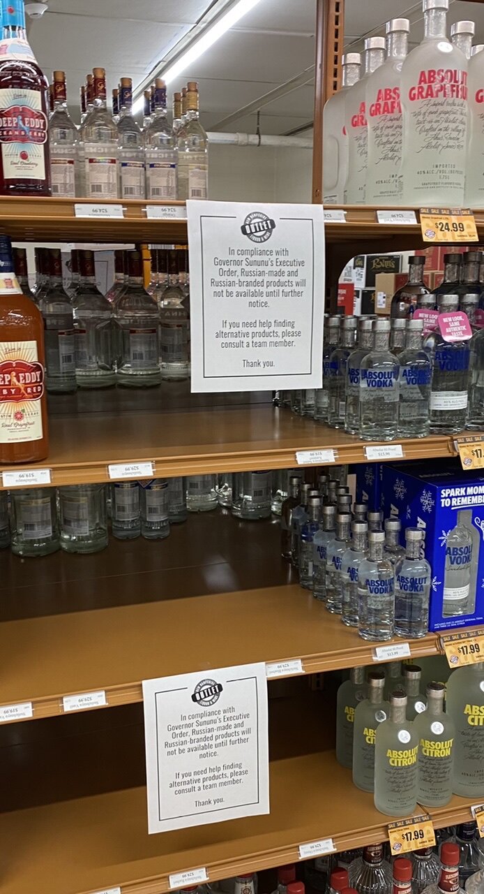
16 hours ago, PhineasC said:
Spotted in the wild in Gorham today:

If you can't read it, it says per Gov Sununu's order, they can't sell Russian vodka any more.
I find this to be pretty silly.
I was in a bar and they were saying how they dumped out all of their Smirnoff. I didn't have the heart to tell them that isn't even a Russian vodka now... LOL
Live free or die!
-
Precip shutting off as close as NYC, fun is over.
-
Snowing nicely now. If this were a month ago this stuff would be stacking up quickly, but instead having a hard time even on dirt surfaces.
-
1
-
-
6 minutes ago, Spaizzo said:
Raining with a mangled flake or 2 down in Derby
Started as rain here, but now down to 35 and light snow.
-
-RA and 37º.
-
2
-
-
Aren't oil companies sitting on nearly 10,000 leases covering millions of acres that they refuse to develop? Should the government hold the CEO of Exxon at gunpoint until they begin to drill more oil? If you are running an E&P business, would you rather oil at $40 a barrel or $150 (like after Katrina in 2005 dollars)? Which price makes your company more money?
-
1
-
-
GOES-T launching in 7 minutes for those interested in such things.
-
1
-
-
25 minutes ago, Hoth said:
I assumed that has been the Chinese plan for some time, probably in coordination with Russia. Open a war on two fronts. I was interested that some in Japan are openly calling to host U.S. nukes in the country this morning. So far I don't think it's getting much traction--totally contrary to their constitution since WWII--but watch that change if China does start menacing its neighbors.
I think we're going to have another nuclear arms race. Every country watching this realizes at the end of the day it's everyone for themselves, and nukes are the great equalizer.
-
29 minutes ago, MJO812 said:
School are closed for this ?
2-hr delay here for basically wet roads and a little slush on sidewalks where you can tell something frozen fell overnight. Would have been happy to get the 2-4 inches that was forecast, but looks like that's not happening.
-
1
-
-
3 minutes ago, tavwtby said:
They must have heard you because you're now in the warning as well.
-
1
-

Preliminarily ... a medium impact partial Miller B, Friday
in New England
Posted
I really dislike it when the NW hills get their own little private snowstorm. Unfair!