

snowman21
-
Posts
4,528 -
Joined
Content Type
Profiles
Blogs
Forums
American Weather
Media Demo
Store
Gallery
Posts posted by snowman21
-
-
25 days until the days start getting shorter!
-
32 minutes ago, Damage In Tolland said:
You do recall when they moved it correct?
Moved it where? It's in the middle of a park, full of trees.
-
Getting some light snow here in the southwest corner of Connecticut. Didn't expect that. April 23rd is pretty late to see flakes around here.
-
T-storm with pea sized hail in Greenwich right now.
-
31 minutes ago, dendrite said:
It’s tough to get a near instantaneous mechanical sensor since you need to get a specific number of revolutions per given time to determine a speed. There’s just not enough rev samples if you try to cut it down to under a second. Now they could be using a 3rd party ultrasonic sensor that would have instantaneous capability, but my assumption was that they had the cups. Here’s Davis’ speed equation calculation...
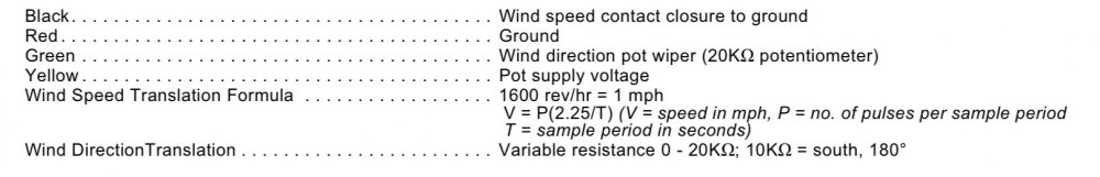
Or do it the old fashioned way with a motor that generates a voltage relative to the speed. Thought some of the earlier Davis stations worked this way hence their caution of extending the wind cable beyond 40 feet because the loss of voltage would cause the speed to be lower than measured.
-
 1
1
-
-
70s and 80s across NYC area and NJ. Got warm quick with this late day sun.
-
Mugs and jugs, margs and oysters on the beach!!

-
 1
1
-
 1
1
-
-
Dews in the single digits above and below zero would normally signal a very cold night ahead, but not so in the winter of 2020. Dew point of 7 under clear skies and a forecast low of upper 20s. At least let us having something this winter.
-
This season will certainly put a dent in the snow climatology. Five inches and just one day of snow cover.
-
Good thing they hoisted the WWA for northern CT. You know it's been a crap winter when they start using the RAH and FFC criteria.
-
Stuck at 5 inches for the season. It's not BDL's whopping 20-something inches, but hey at least it's not zero either. All winter everyone has been loving the warmth and springlike mornings, but if a summer like '09 follows, I don't want to hear any complaining.
-
1
-
 1
1
-
-
Just now, Ginx snewx said:
We were talking salary guys, cmon read with comprehension
Oh sorry. Then yeah I'd agree with that. $100k you can live very comfortably in the NE (and SE) part of the state.
-
3 minutes ago, Ginx snewx said:
100K gets you a 4 bedroom with 5 acres here.
Median home price in Moosup is nearly $200k. I'd like to see this plethora of 4 bedroom houses and 5 acres of land for $100k. Anywhere in Connecticut.
-
Just now, MarkO said:
Seriously, is that the official stance? No longer numerical warning criteria, but relative storm intensity?
Pretty much. We get winter weather advisories now for 1-3 inches. Winter storm warning criteria is 6 inches in 12 hours or 8 inches in 24 for most of SNE. For the ALY zones in CT and MA up through northern New England it's 7 and 9 inches.
-
7 minutes ago, moneypitmike said:
Do you need snow for that down there?
")
Nope. There's always an accident at exit 5.
-
Accumulating nicely. Couple of accidents on 95 - one at exit 2 and another at exit 5, so the roads are getting slippery.
-
-SN has begun.
-
1
-
-
-SN has started.
-
1
-
-
2 minutes ago, wxeyeNH said:
Logan 71.6F
72F. The weather stations don't report tenths. 71.6 is the double conversion error: 72F -> 22C -> 71.6F.
-
70 at EWR, 67 NYC and BDL. Time to install those ACs!
-
1 minute ago, USCAPEWEATHERAF said:
No politics in here please
Well I deleted immediately. Maybe give me more than 3 seconds next time to correct myself please?
-
-SHRASN and 38 here.
-
I've got <2 inches heading into January, and December may actually finish above normal temp wise. Can't really get worse going forward can it?
-
We need a SW CT winter!

June Discussion
in New England
Posted
Aren't there a bunch of dams on the Connecticut River that would prevent you from paddling end to end?