

snowman21
-
Posts
4,528 -
Joined
Content Type
Profiles
Blogs
Forums
American Weather
Media Demo
Store
Gallery
Posts posted by snowman21
-
-
5 minutes ago, powderfreak said:
That’s a lot of shift for only one decade added on those dates...
Wait until next July when the 1991-2020 normals are released and the blow torch 2010s replace the '80s. Could see those dates move another 5 days later.
-
3 minutes ago, powderfreak said:
It does seem like a summer month more often than not. Be interesting to see the different averages if frosts/freezes are later or if that’s just imagined.
They are later. Here are the Connecticut average first frost dates based on the 1971-2000 and 1981-2010 normals to give you an idea of how much they've moved.
ID     Station                  1971-2000   1981-2010   Change(days)
------ ------------------------ ---------   ---------   ------------
BDR    BRIDGEPORT SIKORSKY AP       10/18       10/21             3
BRLC3  BURLINGTON                    9/28       10/03             5
DANC3  DANBURY                       9/26       10/04             8
FVLC3  FALLS VILLAGE                 9/16        9/23             7
GTNC3  GROTON                       10/08       10/17             9
BDL    HARTFORD                      9/30       10/04             4
MHLC3  MANSFIELD HOLLOW LAKE         9/20        9/24             4
NFKC3  NORFOLK 2 SW                  9/22        9/29             7
NRWC3  NORWICH PUB UTIL PLT          9/29       10/04             5
NWPC3  SHEPAUG DAM                   9/28        9/26            -2
STFC3  STAMFORD 5 N                 10/01       10/06             5
STRC3  STORRS                       10/02       10/06             4
WTPC3  WEST THOMPSON LAKE            9/19        9/26             7
-
 1
1
-
 1
1
-
-
22 minutes ago, kdxken said:
We take:
September around here used to be more of a transitional month into fall. It often would start on a warm note, but then turn fairly cool. Increasingly, the month is more like a fourth month of summer with many days well into the 70s and 80s. The nights are also a lot warmer than 30 or 40 years ago.
Since 1872, if you look at the top 20 Septembers you will find 10 of them in the past two decades.
https://www.bostonglobe.com/2020/09/07/metro/keep-your-ac-unit-out-summer-isnt-over-yet/
it's crazy how warm September has been the last couple of decades. You can see it in longer growing seasons and peak foliage being pushed later and later into the fall.
-
1
-
-
1 hour ago, powderfreak said:
Very subtle early color. Not all deep green.
About 4 weeks from hitting peak.

That's nothing. Pete's trees are already bare. You're just now hitting the leathery stage that he reaches in late July.
-
 1
1
-
-
52 minutes ago, dendrite said:
28th most prominent mountain in the CONUS. How many of those 28 have public roads up to the summit?
Pikes Peak is 14kft and has a road to the top. I-70 climbs up over 11kft through mountains. Hawaii has one that goes up 13kft. Just googling around seems like there are tons of roads that go up or through mountains in the U.S., some much higher in elevation.
-
This board talk about Mt. Washington like it's Everest. It's 6,000 feet. That's barely a hill out west. Practically the elevation of Denver.
-
 1
1
-
-
14 minutes ago, moneypitmike said:
Do you know where that 4.4 puts it in the rankings? The rest of the month will nudge 4.4 down a little.
Mean temp this month is 73.1 so far which looks like it would beat out 1906's 72.9 for the top spot if it holds.
-
1
-
-
1 hour ago, Hoth said:
I once got rear ended because I came around a bend and there was a couch in the middle of the parkway.
Yeah I would never go on it unless I was desperate to bypass 95 and the post rd. If there's even the slightest bit of inclement weather trees come crashing down. The interesting part of that is when it was built there weren't all those trees around. I've seen pictures of what it looked like when it first opened and it didn't look like a highway jammed through a forest as it does today.
-
1 hour ago, Hoth said:
Don't know if this is true or not, but my neighbor heard there are multiple fatalities on the Merritt related to falling trees. Anyone else heard anything?
That's called Thursday on the parkway. That highway is a death trap from falling trees, curves and hills, 100 ft exit ramps, and on ramps with stop signs at the end.
-
3
-
-
2 hours ago, weatherwiz said:
TODAY IS A DAY WHY THEY NEED TO BALLOON LAUNCHES FROM BDL...AT LEAST DURING SPECIAL EVENTS.
The models use AMDAR data already, so I don't now how much more useful data you'd get from a dedicated balloon launching site at BDL.
-
25 minutes ago, dendrite said:
Yeah TAN ASOS is relatively new. A lot of sites went online in the mid to late 90s when the automation and METAR took over.
There's also the old Taunton co-op (TAUM3) that pre-dated the ASOS (TAN). Not sure how far back that one goes it looks like it stopped reporting when the ASOS went live, so maybe the airfield had a co-op before automation took over.
-
35 minutes ago, powderfreak said:
Yeah I’m not sure I get the hate on the ASOS records at airports. I mean, that’s what we grew up comparing and still do because there’s a period of record there that makes it so we can see where things fall. The records are what they are...just seems like folks are getting tired of hearing that every summer is a top tier summer. But every summer also seems to end up in the top 10 these days, lol.
I do think TAN gets the award for most uncomfortable readings on the whole this summer.
An ASOS costs more than most people's house, so it's a pretty solid system when properly maintained. I guess people have a beef with the siting of meteorological instruments in places that measure the free atmosphere, and other than airports or a farm where else can you do that?
-
39 minutes ago, ORH_wxman said:
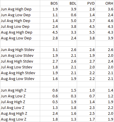
That's usually going to be the case...at least for ORH. Off the top of my head, I know that the summer high temps have a higher standard deviation than the low temps so you are typically going to see the high temps drive the departure on an absolute scale. But on a standardized (sigma) scale, it may be different. I haven't actually calculated to see which has a higher sigma value this summer. My guess is that it is close....the high temps have been very warm....they just haven't been driven by extreme heat. More the "lack of cold max temps". Very consistently hot max temps....just not extremely hot where we see a lot of record max temps fall as in past hot summers.
Here is the same table in a standardized scale. Standard deviations taken from NCDC's 1981-2010 climate normals. Bottom grid (z-scores) is just the top grid divided by the middle grid.
-
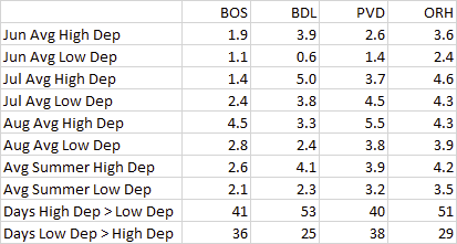
Here are the departure splits between the highs and lows. This summer's departures were not driven by warm nights. In 9 of the 12 station-months, the high temperature departure was greater than the low temperature departure, and the number of days where the high was warmer relative to average compared to the low was also greater.
-
1
-
-
1 hour ago, powderfreak said:
We have a wall unit but if I had window A/C units up here I would've pulled them out this past week to just allow the windows to be open and free. No way am I leaving my windows all jammed up with A/Cs for the threat of needing them on a random day or two when the majority of the time you can just let the breeze in. They look horrible too, not worth it for a random day or two in the NNE climo now.
Without A/C units, how do you plan on surviving Torchtember?
-
1
-
-
3 hours ago, HoarfrostHubb said:
And if they are lucky a membership in the Jelly of the Month Club
That's the gift that keeps on giving the whole year.
-
2
-
-
20 minutes ago, Damage In Tolland said:
Endless summer toorrcchh
Wow that forecast really going out on a limb there. 75% of falls going back 20 years are above normal.
-
36 minutes ago, Dan said:
Hard to cool off at night anymore.
-
1 hour ago, Whineminster said:
Didn't parts of SNE reach 100 degrees in September a few years ago?
Might have. At the SNE climate sites there were upper-90s in September in 2018, also in 2015, and 2013.
-
Nice early fall feel out there today. Cool this morning, and now sunny with temps slowly climbing through the 70s at midday.
-
Keep in mind we're losing 3 minutes of daylight per day, means are declining, sun angle is rapidly declining. It's not just about the pattern. There's a reason climo is climo, and even the mighty BDL 'mac has trouble getting to 90 after about the 23rd of August. If Ryan's 10-day is right, which takes us to the last week of August, yesterday and today are critical for BDL breaking the record. If you're expecting a late summer like '83 or '73 then yeah I guess it doesn't matter and we'll blow past the record, but I wouldn't bet on it.
-
3
-
-
90-degree days at BDL:
1983 38
2002 35
2020 34
2010 34
1965 34
2018 32
1966 32
2016 31
1991 31
1988 30
1973 30-
1
-
1
-
-
BDL has to get to #35 today or it'll be like the Sox 5 1/2 out with 12 to play against Yanks, Rays, and Jays.
-
28 minutes ago, Damage In Tolland said:
Not in this climate . They’ll crush the 90+ record
But even in this climate BDL isn't putting up big 90+ numbers in September. We have to be at 36 or 37 by the end of this month to have a real shot and next week isn't looking good. Sneaking in that extra day tomorrow will be important. Expecting more than a couple of 90+ days in September even in this climate is asking a lot. Normal at BDL I think is 0.7 days and we've averaged 2.2 over the past decade despite how warm Septembers have been.

September 2020 Discussion
in New England
Posted
So in addition to the beefalo that's been on the loose for the last couple of weeks, now there is an alligator to worry about?