

mayjawintastawm
-
Posts
1,349 -
Joined
-
Last visited
Content Type
Profiles
Blogs
Forums
American Weather
Media Demo
Store
Gallery
Posts posted by mayjawintastawm
-
-
5 hours ago, ValpoVike said:
Poof, gone.
The story of the Spring to date.
-
2 hours ago, smokeybandit said:
GFS wants to do the snow thing again this coming weekend.
GFS is like a 6 year old kid... entertaining, but enough to give you a headache sometimes.
-
1 hour ago, smokeybandit said:
The reported totals near me seem ridiculously low. One report from this morning is 3" about 10 miles south of me, yet I had 3" by 6pm yesterday.
Precip totals around the Metro area were also lower than predicted, 0.1" to 0.3" generally (we had 0.13" and the point forecast was 0.51" yesterday morning). You were probably under a couple of micro-bands that did the job. Driving around yesterday evening, the snow intensity was incredibly variable just over a mile or two in Lone Tree-Centennial-Greenwood Village. I wonder what causes those effects- subtle convection?? Lake effect from Cherry Creek Reservoir?

-
2 hours ago, smokeybandit said:
Final tally about 6" after the overnight bands
Smokeybandit, yours was the highest in the Metro area, looking at COCORAHS. Everywhere within the 470 extended beltway was <1" and the only 6" totals outside of the foothills were at the top of the Palmer Divide from Black Forest on west. Congrats!
-
Nice. Got half an inch, then dryslotted. More later maybe. Fertilized the dust yesterday.
-
Looks like tomorrow might be the first rainy day in >6 months for the Front Range. Bring it on! Now of course that means it will go "poof".
-
16 hours ago, cstrunk said:
The Rocky Mountains?
Sorry, couldn't resist.
OK, OK.... you win.
") but the usual springtime wetness from the south and east has just failed to materialize so far. I guess it all turned into tornadoes in the Mississippi Valley.
but the usual springtime wetness from the south and east has just failed to materialize so far. I guess it all turned into tornadoes in the Mississippi Valley.
-
 1
1
-
-
I'd love to get more than 0.1" moisture in any form. Something is persistently keeping this from happening east of the Divide and south of Wyoming for about 500 miles.
-
DEN broke the record low for April 5 with 11 F this morning, old record was 12 in 1983. My house also 11.
-
About 0.5" here.
EDIT: final was 1.5" for the calendar day.
-
So freaking dry. March with 0.24" water and 3.2" snow at my house, well under an inch of water for Q1 2023. Nearest NWS climate station at Centennial Airport has 0.70" YTD. No ignition sources, please.
-
Great. We got graupel for 2 minutes that added up to a trace. March precip to date 0.18" and 1.6" snow.
-
6 hours ago, Chinook said:
It has been two years since the Big One.
That was fun. Boy was I tired after shoveling that- was about at the limit of throwing snow up onto the banks. Only took a couple weeks, though, before it was mostly gone.
-
6 hours ago, smokeybandit said:
For being the snowiest month of the year in NE Colorado, March sure doesn't seem interested in obliging.
March has been awfully weird lately. 4 of the top 20 least snowy Marches (since 1882) have been since 2011.
-
1 hour ago, Chinook said:
Looks like the snow just isn't going to be there. Keep up the hope for more snow in March. Northern Colorado isn't doing badly on total snow for the cities (I think). The snow water equivalent is 104%/121% in the mountains. The areas well east of I-25 seem to have gotten quite a bit of snow over this winter.
DIA: 41.6"
Boulder: 67.3", just a bit above normal
Fort Collins: 28.5", below normal
Greeley: 31.1", above normal
Longmont Co-op: 41.9" that seems much better than Fort Collins
Walden: 60.2 (above normal for this higher elevation location)
And 7.3" here in Feb for a total of 40.4".
-
And now there is no system. Back to super dry and windy like 3 of the last 4 Marches.
-
Hate to say it, but the ugly second half of winter dry pattern is reasserting itself here... though cooler than normal, Centennial (nearest station to me) is only at 0.42" for Jan-Feb and my house not much more than that.
-
-
15 hours ago, Chinook said:
Not to drive you guys nuts, but I want to commemorate one of the first times I've seen a blizzard warning for southern California, even the San Gabriel Mountains north of Burbank.
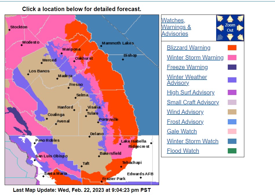
Wondering what blizzard criteria for Southern CA would be... 1 or more snowflakes visible within 1/4 mile and temps+winds making it somewhat uncomfortable to wear shorts.
-
 3
3
-
-
7 hours ago, smokeybandit said:
Major bust low on the low temps. -12 degrees this morning after a -1 forecast
Indeed. -10 here and forecast was +2.
-
So, the "low end forecast" for snow from this "storm" was 2.2 inches. We got 0.8", if I lean the ruler over just right. And there were supposed to be some wind gusts. Max wind at our house was maybe 12 MPH. Well. It is cold like was forecast.
-
OK so this is amazing. Never in my 20+ years of reading AFDs have I seen a poem in one. Here is tonight's from a likely bored forecaster named Rodriguez at BOU: so cool.
Area Forecast Discussion
National Weather Service Denver/Boulder CO
848 PM MST Fri Feb 17 2023

.UPDATE...
Issued at 819 PM MST Fri Feb 17 2023

`Twas a day of photogenic clouds,
and it drew the weather weenie crowds.
They come in search of information,
But I am a man of evasion.
In my brain, emptiness abounds.
-
3
-
-
20 hours ago, ValpoVike said:
Ratios can be frustrating here. Personally I use 10:1 as I have seen too many storms with much higher predictions miss terribly.
Ratios are all over the place, but generally 10:1 would be conservative. For example, the 6.3" we got here total over the last storm was from 0.36" of water (17.5:1 average) and I think that was a fairly typical storm. On the other hand, the 11ish inches we got right after Christmas had well over an inch of water in it, probably around 1.3 inches (8.5:1) and maybe even a bit more. That was definitely heavier than usual. Looking at DEN from Dec 2021-Mar 2022 (excluding a rainstorm in late March), there was 46.7" of snow with 2.88" water, so average 16.2:1. My sense in our 13 winters here is that the frequent "misses" are more from QPF that doesn't pan out as predicted.
I'm guessing WY would be drier and colder than here.
-
We've been under this really narrow band off and on all afternoon... 5.4" so far from the storm, the last 2" super-low density snow. Could probably do the driveway with a leaf blower, mostly.
Mountain West Discussion
in Central/Western States
Posted
Nice 2.5" of snow last night, the most moisture at one time in a couple months. Pretty.