

mayjawintastawm
-
Posts
1,449 -
Joined
-
Last visited
Content Type
Profiles
Blogs
Forums
American Weather
Media Demo
Store
Gallery
Posts posted by mayjawintastawm
-
-
51 minutes ago, Roger Smith said:
Very cool for late June in PAC NW, currently only 48-50 F at lower elevations of n Idaho and nw Montana, se BC, and snow is reported in mountain passes. A cold drenching rain here, not good for a weekend but great news for forest fire suppression. It is only 45F at my elevation (normal here is 80F).
I'll take it over the sauna that we currently have. 98/42 at 5 PM MT IMBY. 98/20 at Buckley AFB nearby...6% RH will dry you out in a hurry.
-
We seem to have threaded the needle with all 3 rounds so far, with only 0.03" at the house, but we'll see what the rest of the afternoon brings. Car is inside and tomatoes are under the porch, so that pretty much guarantees quiet weather.
-
3 hours ago, smokeybandit said:
1.5" overnight.
Looks like south and northwest were the winners this time. We had 0.60". From COCORAHS

-
12 hours ago, ValpoVike said:
May has been good up here. Month to date is 3.41”, and more coming.
We really caught up yesterday with 2.64" of rain in 24 hours. Closing in on 4 inches for the month, who knew? Then again, May is often the surprise flood month- 2 years ago we had close to 6 inches in a day and a half, that washed out the road over Cherry Creek in the state park for close to a year. Same road had a foot of flowing water over it in the same place this morning.
-
Got 0.8" of rain in the last 20 minutes along with a good bit of small hail. Rain rate peaked at 3.35 inches/hour. Localized flooding, of course.
-
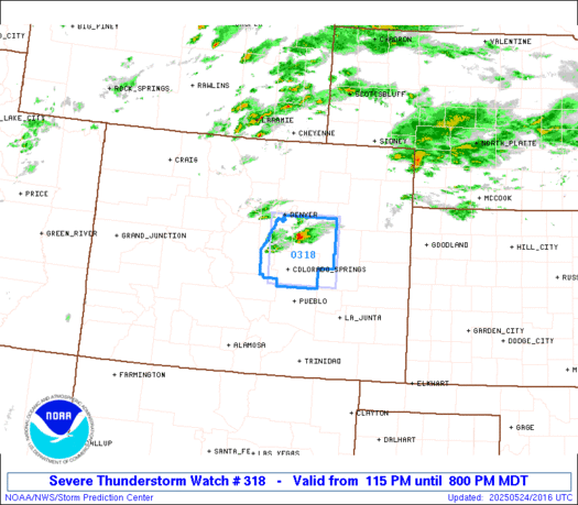
This is possibly the smallest severe thunderstorm watch I've ever seen. Pretty cool out now, though humid, doesn't feel like a severe weather day, though there's one supercell out near Kiowa (Kiowa has a semi-permanent supercell, I think).
-
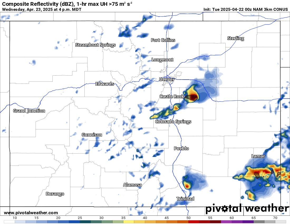
3 hours ago, mob1 said:
TDS with that storm now (though velocity scans haven't looked overly impressive in the last few scans). Storm keeps cycling as well. CO tornadoes are always photogenic and have interesting evolutions.
Just got back from a couple hours on the bike near Centennial and saw at least 2 of those storms form right overhead and move quickly to the northeast. They're going from nothing to nasty/starting to rotate in 30 minutes. Missed getting hailed on (0.5-0.6" hail at our house) by about 10 minutes
") ... one more reason to wear a helmet.
... one more reason to wear a helmet.
-
 1
1
-
-
1.01"- can't complain too much. All the showers today missed one direction or the other.
-
Rain may not be continuous with this one, but the showers have been potent. The conveyor belt worked its way north during the morning and we're on the very north edge, having had 0.74" rain in 8 hours. Looks to continue for a while so we may get our 1" after all. 38-39 F at 5650'. Brr.
-
Here we go again. What can you do when all the models say you'll get 1"+, 12 hours before the event. Gonna be a long fire season.
Forecast for Sunday: Rain late. Measured precip: zero. Forecast for Monday: Rain late. Measured precip: zero. Today the closest precip is about 70 miles south.
-
45 minutes ago, smokeybandit said:
GFS wants to dump about 5 feet of snow on Pike's Peak this week.
NAM has a bunch of snow east of 25. Even the Euro has snow.Given recent May-hem, I wouldn't be surprised. Hot today though! Was 79 a few minutes ago, wonder if it'll break 80 before the clouds take over.
-
2 hours ago, ValpoVike said:
I have to fly to Germany on a business trip later this summer. Definitely planning to target this flight. Beats the heck out of the old 747’s that Lufthansa had been using for the route.
600 passengers... that's called flying a building, not an airplane. Seen a couple up close at Dulles on the shuttle between terminals, wow. Missed this one's landing by an hour and a half on Wednesday, but seen quite a few take off and land at other airports. They actually don't seem to take as long to get off the ground and climb out as the 747s do.
-
First week of May always seems to be the only gloomy, wet week of the year here in the Denver Metro (I'll take it!)- 0.40" rain last night and several days more predicted next week.
-
Reposted from Colorado Storm Chasers FB group: it seems like the fan in Elbert County (see discussion from winter thread a couple weeks ago) will be in full operation tomorrow.

-
Opened a warm season thread for now through Octoberish.
-
On to a new thread, hoping for moisture this warm season. NWS says warm and dry, what a surprise. Fortunately, mountain snowpack most places is reasonable.
-
Just a note as the warm weather 2025 thread opens- Loveland ski area has had 20 inches of snow the last 48 hours!
 One last opportunity for a powder day- unfortunately too many Easter weekend plans.
3.6" snow total in April, 51.1" on the season unless we get anything more.
-
A wet inch here, nothing to write home about except for the unseasonable warmth and all the flowers out earlier this week. Total moisture 0.09" at both DEN and APA.
-
But as always, QPF for this "storm" for my area goes 0.9" (Mon), 0.7" (Tues), 0.6" (yesterday), 0.45" (now)... I'll expect 0.1" and be happy with 0.4". Glad I don't farm for a living.
-
5 hours ago, Chinook said:
GFS has 8" of snow for Boulder this week. NWS has 0.6"-1.1" of QPF for the area (5 days)
Would be nice if either of those came close to verifying.
-
Got 0.1 inches of snow last night, total 2.1" in April. Lots of chilly blossoms on the trees, but it didn't get super cold (low of 30 here) so things should be OK.
-
1 hour ago, Chinook said:
My friend once proposed setting up a myriad of large concrete structures at the OH/IN border, possibly with spiral structure, to make tornadoes lose their spin as they cross into Ohio.
That could attract tourists from as far away as... Colorado. Driven that a bunch of times, and by that stage, anything is worth stopping for.

-
Seems like Elbert County causes practically anything that goes through there to rotate. Must be a great big hidden fan or something.
-
On 4/1/2025 at 6:07 PM, Chinook said:
You can actually see wind shear in this
You know, I thought I saw that too, in my backyard with clouds at different levels moving in opposite directions about 5 PM yesterday.
0.5" of wet snow last night, to combine with 0.2" in all of March (!) for 48.0" on the season to date. Will we get more this week?
Mountain West Discussion
in Central/Western States
Posted
0.72" rain yesterday, we had tiny hail but the plants did OK.") Really feels monsoony out there, DPs in the mid to upper 50s. Nice!
Really feels monsoony out there, DPs in the mid to upper 50s. Nice!