

mayjawintastawm
-
Posts
1,449 -
Joined
-
Last visited
Content Type
Profiles
Blogs
Forums
American Weather
Media Demo
Store
Gallery
Posts posted by mayjawintastawm
-
-
A rancher friend of mine just north of Burlington CO observed a temp drop of 53 degrees (47 to -6) in 50 minutes yesterday afternoon on her home weather station. That struck me as a possible state record if it were official, but I can't find any CO state records like that. DEN broke the station record yesterday with a 42 degree 1-hour drop, and the national record is 58 degrees in Spearfish SD in 1943. Anyone have any info about what the CO state record is, or even if one exists? Would be cool to tell her that her place broke a record, even if unofficial.
-
We got 1.6" with a low of -14. Once the sun came out it was actually enjoyable with adequate clothing. My year-old Irish Wolfhound was enjoying it immensely. Somehow the cold doesn't bother her feet as much as with the other dogs.
-
Temp dropped 23 degrees in 60 seconds here at 4:22 PM. Now it's -1 and sand is falling from the sky.
-
 2
2
-
-
2 hours ago, smokeybandit said:
50:1 ratios!
Unfortunately, probably too much wind to see what that 50:1 looks like. A couple inches of windblown sand with drifts in the corners, most likely.
-
I'm thinking that if the current forecast temps verify, Thursday AM could be the coldest day in the Denver Metro since we moved here in August 2010, and if the winds verify, definitely the coldest with windchill. Anyone been here long enough/have the data to back that up, or not?
EDIT: Nope, looks like it was -20 at DEN on 12/30/14. Still wonder about the windchill, don't know where to get data for that.
-
1
-
-
Hope there's snow with it if that happens. Tired of being freeze-dried. 0.4" total from the "storm" last night and today.
-
17 minutes ago, Chinook said:
New GFS for Colorado
So, like, one side of my yard will get 2 inches and the other side 6?
-
Nice. 2.0" here though I measured a couple hours after the snow stopped, so with high fluff factor there might have been a little more. Darn cold, more like January.
-
7 hours ago, southmdwatcher said:
Wow, hope we never have to do another March 1984/April 16 2011 Carolina's Outbreak event.........
One of the few times I've actually been scared about weather is when I was driving through the NC nighttime outbreak the Sunday after Thanksgiving in 1988 as it was forming. Couldn't see a damned thing driving west on I-40 toward a work assignnment. Next morning I woke up to news that there had been big and deadly tornadoes just a couple counties east of where I was. Spooky.
-
1
-
-
18 minutes ago, Wmsptwx said:
Looks like decent event, surprised it’s so dead in this thread.
Wonder if it's because the event bullseye is split between regions on this board... maybe good to cross-post in the SE and TN Valley groups?
-
3.8" IMBY, combined with an inch on Tuesday makes 6.8" for November and 7.8" season to date. Not a bad start, though I still have to rake most of the leaves.

-
2 inches in my yard, a little more in the park down the street. Most came during the Thursday evening rush hour. 100 vehicle pileup in Denver on 6th ave early this AM on that big long overpass over I-25 from Kalamath to Federal. Ouch.
-
I had to fly out early morning the 27th and there was nobody at our house to measure. The 4 nearest COCORAHS stations reported T, 1.0, 1.3 and 1.4 inches of snow and there were a few patches in the shade when I came home yesterday that looked about an inch, so I'll call it our first 1.0 inch of the season on October 27th.
-
ValpoVike made one a couple weeks ago. Let's switch over there.
-
5 hours ago, Chinook said:
You guys can feel free to start a winter discussion, but as of right now, only a dusting of snow at 12000 feet means it's hardly much of a winter discussion yet.
In Ohio today, the freezing level is 2950 ft above sea level, as we are in a polar air mass that is nearly the worst weather we could have at this time of year.
Nothing yet. We did have the first freeze of the season at my house today (29 F at about 6:30 AM) but that ain't sayin' much. Dry as a bone the last two weeks.
-
On 10/14/2022 at 12:09 PM, ValpoVike said:
Still in fantasy-land, but the GFS thinks that it may be time to start up a winter thread in the last week of October.
We still haven't had a freeze at my house, about as late as I can remember in our 13 falls here. The higher peaks are still pretty much snow-free too. Can't wait.
-
On 10/6/2022 at 12:44 AM, Panes and Portlets said:
Off topic but the department head of Uni of Arizona's ATMO program, Dr. Thomas Meixner, was murdered today by a former student.
Oh no, how horrible. RIP. Academic world is tough enough without having to watch your back.
-
On 9/18/2022 at 9:16 AM, Chinook said:
Next quiz. Where was this taken?
.thumb.jpeg.278d00231117041dae611d498e667327.jpeg)
Quick Google search of "Kawuneeche Valley webcam" has the answer
") This view looks west toward the Never Summer range- you can tell because of the horizontal line where the Grand Ditch was dug a long time ago. The damage from the 2020 East Troublesome fire is still incredible a mile or two north of here - I was there last month.
This view looks west toward the Never Summer range- you can tell because of the horizontal line where the Grand Ditch was dug a long time ago. The damage from the 2020 East Troublesome fire is still incredible a mile or two north of here - I was there last month.
"Located on the west side of Rocky Mountain National Park one-half mile from the Grand Lake Entrance Station, Harbison Meadow in the Kawuneeche Valley teems with wildlife and wildflowers."
-
Pretty disappointing so far for the Denver metro, with 0.12 at DEN, 0.06 at APA and 0.07 at my house. Radar has everything pretty much north of town. Most of the past several cool/wet scenarios have turned out similarly, with southerly midlevel flow downsloping off the Palmer Divide.
-
7 hours ago, Chinook said:
I think it is looking southwest towards Chasm Lake. Maybe somewhere on road 7? Wild Basin Lodge (Sandbeach Lake Trailhead) is the wrong angle.
Yeah, sun angle would have the camera roughly N-NE of the peak- but weird that the RMNP website has the description of the camera with this angle around Tahosa on Hwy 7 which seems well south. Must be super zoomed-in as I've driven that route many times and can't recall that nice a view.
Related to weather, there is no snow visible on any of the mountains from Denver now. Getting a bit late for that. Hope this changes soon- supposed to be around 90 mon-tue.
-
On 9/5/2022 at 5:11 PM, Chinook said:
It's up to 102 degrees in Fort Collins with one local observation. Sheesh, is this September or July 4th?
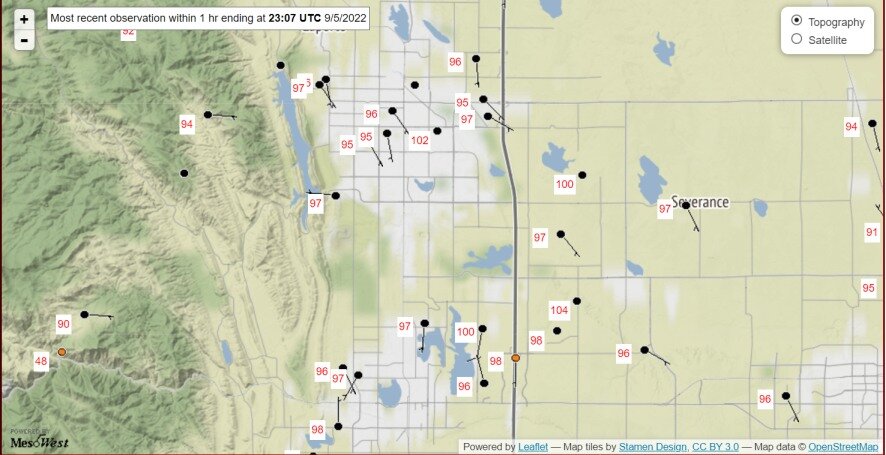
Even more remarkable is that it's with a whole lot of smoke. If it were completely sunny it'd likely be 100+ for 3 straight days in DEN. Really unprecedented.
-
1
-
-
Just bumping this up, since it's been >10 days without a post.
Monsoon season appears to be over for NE CO, after a pretty nice couple of months. The mountains visible from Denver have no snow at all- this is the 2-4 week period for that. Hopefully it will not last long. The summer heat re-establishes itself with 90s on the Plains for the next week, modified due to shorter days. Once that breaks, time for a fall/winter thread. It may be a while though... hopefully no major fires.
-
6 hours ago, Chinook said:
Here is the CoCoRAHS precipitation since July 1st at Centennial, south of Denver. Not too bad, considering how badly the Denver area needed rain.
I'm close enough to Centennial Airport (4 miles from the recording site I think) that when I miss a measurement I use theirs. This week the core of the biggest storm went between Buckley and Centennial, more or less over and just east of me. This summer has been weird though- other than a very general trend for less precip the further east you go, it's been pretty random, with big slugs of rain from a few storms scattered around the metro area. DIA has missed out on almost all the storms.
-
19 hours ago, mayjawintastawm said:
Got 2.06" here, the most in one day (or in 3 hours!) since I got the weather station, and 22% of our yearly precipitation to date. No flooding in our yard or basement
Update: 24-hour total from 2 PM Mon-2 PM Tues 3.70". That's definitely the most IMBY since the Sep 2013 floods.
.jpeg.8b5a5f611b7edebd925baf8811791dff.jpeg)
Mountain West Discussion
in Central/Western States
Posted
Light rain and low 40s this afternoon, rare for this time of year. Gloomy. Makes me glad I don't live in Chicago or the PNW. Models go nuts with QPF this evening, and our change to snow is almost always quicker than others. We will see! Putting the snow board out in the yard now.