

Shack
-
Posts
244 -
Joined
-
Last visited
Content Type
Profiles
Blogs
Forums
American Weather
Media Demo
Store
Gallery
Posts posted by Shack
-
-
On 2/27/2024 at 6:03 PM, katabatic said:
I live in Maryland but coming out to Donner ski area for the storm. Looking forward to being in your area!
I see Donner is shut for the day. Hope you're having an epic trip.
I would've liked to make it out. Gonna be one to remember, for sure. Post pics !
-
My daughter lives in St. Louis.
Yesterday's high was 86deg and they set a record.
Then, this morning , STL reported an overnight low of 26deg and "Light Snow" from 3:55a.m. until 4:55a.m.
That's the definition of "weather-whiplash."
-
 2
2
-
-
Snow for Larry.
And, where's Metallic now?
Snow in Waycross.

-
2
-
 1
1
-
-
Four days ago at MCN the low was 16.
Today, the high was 77.
I'll take it.
-
NC folks: GFS still giving hope.....(yeah, I know)

-
2
-
-
Warner Robins AFB reporting sustained 40mph wind with gust to 68.
-
1
-
 1
1
-
-
MCN at 64deg. Wind at 24 with gust to 43mph.
Squall line incoming and butt-puckered.
-
9 minutes ago, eyewall said:
Well if it is going to be torchy for Christmas might as well get out and see the lights for a bit:
Quite wonderful, sir.
62deg and a cloudy, slightly-wedgie, somewhat moist, Christmas morning here in Lizellaburg.
-
1
-
-
63deg and green.
Green, as in the sky (cloud) color at daybreak. Always an interesting spectral phenomena to me.
Thunderstorm incoming. Who doesn't love a good thunderstorm at daybreak.
-
Nice look.
No cold.

-
On 9/4/2023 at 7:09 AM, Buckethead said:
Welcome to WNC!
Sent from my SM-S908U using Tapatalk
Thanks, Bucket.
I've always enjoyed your reports from up the hill.
-
On 9/1/2023 at 11:30 AM, beanskip said:
Saw this in the TLH discussion a few moments ago:
Area Forecast Discussion
National Weather Service Tallahassee FL
1108 AM EDT Fri Sep 1 2023

...New UPDATE...

.UPDATE...
Issued at 1108 AM EDT Fri Sep 1 2023

Torrential rainfall rates with an extremely moist air mass are the
main concern today. Earlier this morning, the weatherstem at the
Ochlockonee Boat Ramp in Franklin County had an instantaneous
rainfall rate of nearly 6.5 in/hr. PW values are in the extremely
moist 2.2 to 2.4 inch range. We also have a backdoor front our
Florida counties that will serve as a focus for further
development today. Will be watching trends closely to see if a
Flood Watch will be needed.
That would be impressive to watch.
Any updates on whether any adjacent sites had similar values?
-
11 hours ago, Met1985 said:
Congratulations and welcome to the mountains!
Thanks, Met.
Feeling very fallish here in Macon, today, but glad to have an escape for our perpetual summer here.
-
1
-
-
12 hours ago, Tyler Penland said:
Welcome to WNC! That whole area is absolutely beautiful. Tons of waterfalls, very close to the BRP and you aren't too far from great hiking in NE GA too.
That area always does well during Miller As so here's hoping you get a big one this winter.Thanks, Sir.
We hiked down the Glen Falls trail last week with our daughter and future son-in-law. Just, gorgeous.
And, I'm always pulling for the Miller A's !
-
13 hours ago, franklin NCwx said:
Congratulations! How far outside of highlands? You're not too far from my house
About 6 miles. Just up the hill from the Scaly Mountain Outdoor Center tubing hill.
-
Good Friday afternoon, mountain-folk.
I can, today, finally feel like I have some legitimacy posting in this sub-forum. My wife and I, although still firmly homesteaded in the barely-above-sea level, relative flatness of western Bibb County, Georgia, bought a little piece of altitudinal heaven yesterday.
We closed on a little house outside of Highlands, down hwy 106 towards Scaly Mountain. Sits at 3,717ft, as best I can tell.
Looking forward to hanging out there and will be setting up new weather station when my Starlink finally arrives.
-
6
-
-
Thankfully, the terribleness for my area has subsided.
Our NWS-Tropical Storm-Warned, county endured nearly an INCH, (1) of precipitation, along with a howling sustained wind of hmmmm, (checks again).......11mph with catastrophic gusts to........wait for it,.........23mph.
-
2
-
-
Just now got upgraded to Tropical Storm Warning here in Macon(Bibb County)
Thinking my friends to the south around Valdosta are going to get an (unfondly) memorable event.
-
1
-
-
75 and muggy this early morn.
And, just now, my weather radio just went off to tell me that my county(Bibb) had been upgraded to a Tropical Storm Warning.
-
Hot.
Again.
101deg at MCN. Makes three days in a row above the century mark.
-
Summery here in Macon. 90deg at my place. 88 for the official high at MCN.
-
1
-
-
64deg and sho' nuff foggy here in Macon.
And, we had 5.4" of rain in about a 8 hour period ending yesterday at about 11:00. Possibly more upstream from us. Lake Tobesofkee flooded it's banks for the first time in my 18 years on it. Boathouse is a mess, of course, but the really interesting thing is sheer amount of debris in the water this morning. I went out at daybreak and I swear you could just about walk across the whole thing.
Logs and sticks and lumber, Oh, My !
-
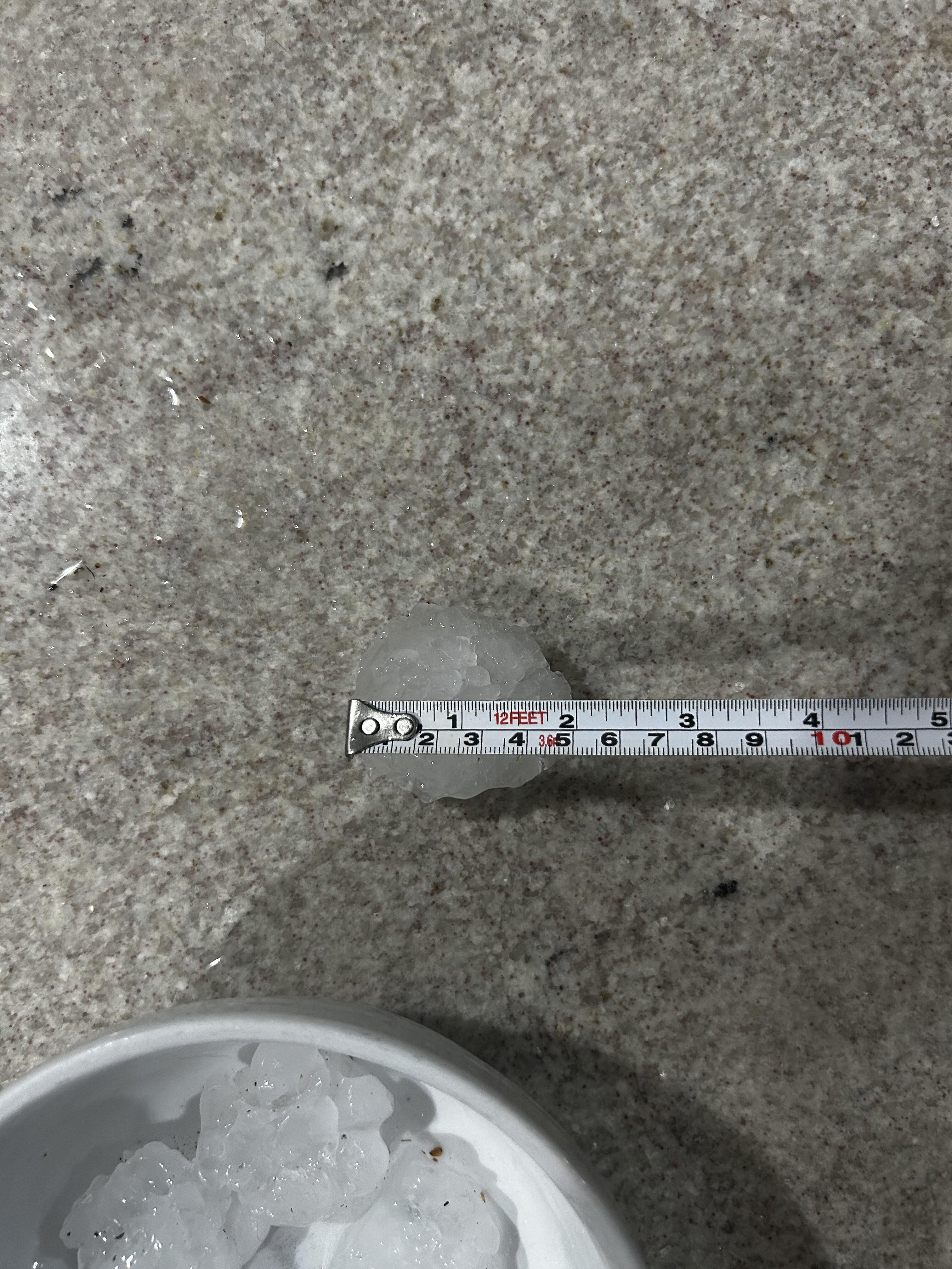
26 minutes ago, purduewx80 said:
Huge hail for a couple minutes in ATL just now. Biggest stone I found is 2.1”.

Impressive return(looks to be approaching 60dbz) north of downtown. I'm guessing this came from somewhere in that fun, little, bunch of mucho-moisture?
Here in Macon, 70deg, and awaiting the midnight round of watches and warnings.
EDIT: posted this and then I see a white spot in that return (60+dBZ). I'm guessing that's some roofer contractor's dream radar return.
-
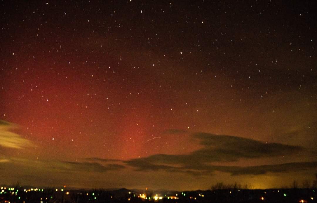
1 hour ago, Tyler Penland said:
Not ground weather related but space weather news.
Caught the auroras last night up north of Boone. 3rd time seeing them from down here which is awesome. Eventually I'll get a chance to go north and see the big ones.
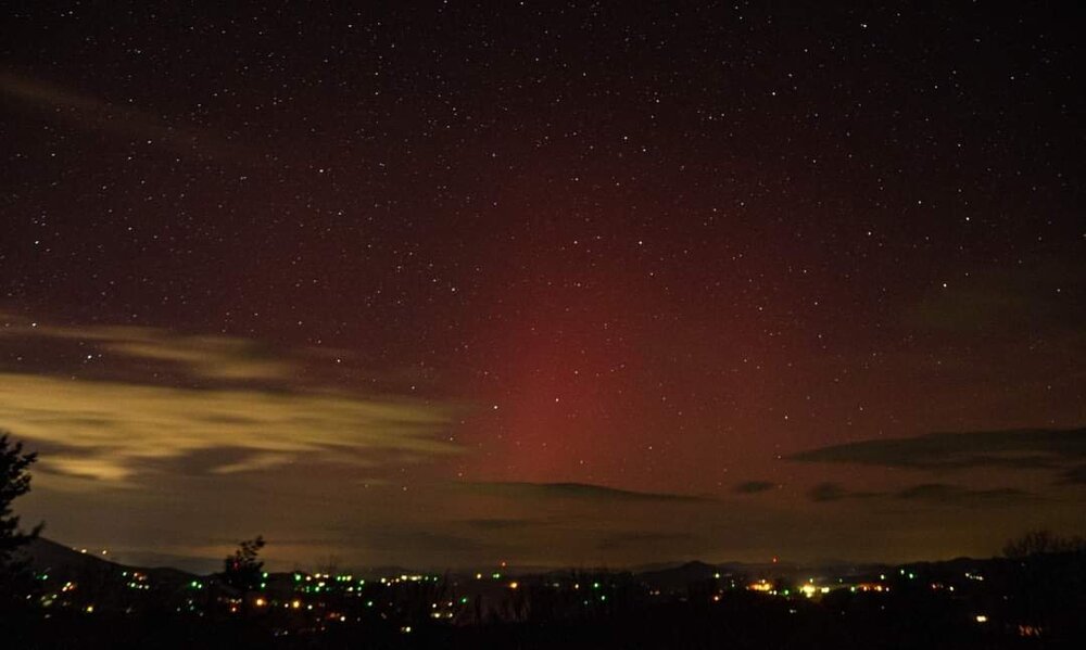
Sent from my SM-S911U using Tapatalk
That is awesome.
I, too am jealous.


2023-2024 Fall/Winter Mountain Thread
in Southeastern States
Posted
Another good Tahoe-Area link to watch. Right now, the Snowcat and and a bobcat trying desperately to keep ahead of accumulations.
https://portal.hdontap.com/s/embed/?stream=downhillDeck_tahoedonner&ratio=16:9