winter_warlock
-
Posts
3,373 -
Joined
-
Last visited
Content Type
Profiles
Blogs
Forums
American Weather
Media Demo
Store
Gallery
Everything posted by winter_warlock
-
I remember the storm only because I had to go to my brother's funeral right before it hit
-
LWX has a forecasted low of 18 for me. Yet I'm already down to 19.3 lol.
-
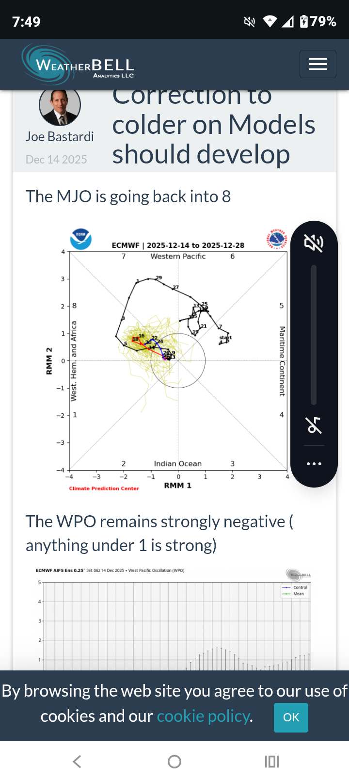
FWIW .. from JB ..
-
Ravens played thier best game so far this year!! A shutout! Beating the Bengals 24-0!!
-
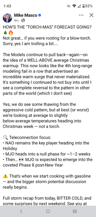
Very nice read from respected Met Mike Masco about. Models pulling back on the idea of a torch Christmas!!
-
12/5 : .75 12/14 : 2.125 Total : 2.875
-

12/14: Sunday funday? Will the south win again?
winter_warlock replied to TSSN+'s topic in Mid Atlantic
Looks like a Christmas card bro!! -
12/14: Sunday funday? Will the south win again?
winter_warlock replied to TSSN+'s topic in Mid Atlantic
So far for December I have 2.875 inches pretty much at climo for eastern Baltimore county! And we still got 17 days to go!! -
12/14: Sunday funday? Will the south win again?
winter_warlock replied to TSSN+'s topic in Mid Atlantic
Snow has stopped here in sparrows point MD partly cloudy skies. I got 2.125 inches but the story now is temps. Temperature has dropped 2 degrees in last hour. Down to 28.4F -
12/14: Sunday funday? Will the south win again?
winter_warlock replied to TSSN+'s topic in Mid Atlantic
2.125 inches here in sparrows point MD 30.6 F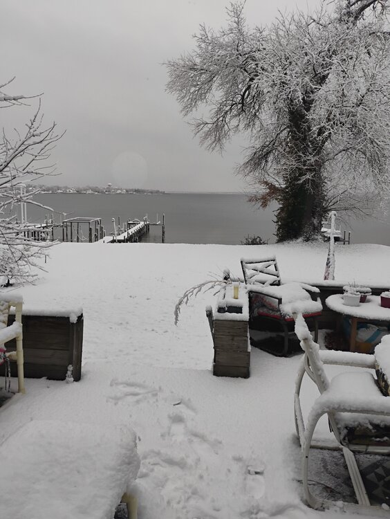
-
If that were to verify this forum would probably crash lol
-
12/14: Sunday funday? Will the south win again?
winter_warlock replied to TSSN+'s topic in Mid Atlantic
Yet LWX says 1 to 3 lol -
12/14: Sunday funday? Will the south win again?
winter_warlock replied to TSSN+'s topic in Mid Atlantic
How did the AIFS look? -
12/14: Sunday funday? Will the south win again?
winter_warlock replied to TSSN+'s topic in Mid Atlantic
I hate those damn things lol -
Lmaooo okay!!
-
12/14: Sunday funday? Will the south win again?
winter_warlock replied to TSSN+'s topic in Mid Atlantic
True.. lol
-
12/14: Sunday funday? Will the south win again?
winter_warlock replied to TSSN+'s topic in Mid Atlantic
Well is the ukmet so... -
12/14: Sunday funday? Will the south win again?
winter_warlock replied to TSSN+'s topic in Mid Atlantic
They also take into account location. If u live in Alabama, a 1 to 3 inch storm is warning level. We're as that's just an advisory here,.. but I could be totally wrong... As my wife likes to tell me lol -
12/14: Sunday funday? Will the south win again?
winter_warlock replied to TSSN+'s topic in Mid Atlantic
They gotta do that and use the stuff to get there budget for next year -
12/14: Sunday funday? Will the south win again?
winter_warlock replied to TSSN+'s topic in Mid Atlantic
Color code says 2 to 3. Noaa is goofy lol -
12/14: Sunday funday? Will the south win again?
winter_warlock replied to TSSN+'s topic in Mid Atlantic
I agree. Latest modeling shows warning criteria for a lot of us . Maybe LWX is waiting till the afternoon update -
12/14: Sunday funday? Will the south win again?
winter_warlock replied to TSSN+'s topic in Mid Atlantic
Looking like a decent 3-6 inch snowstorm for a lot of us in central md se pa, northern Delaware. Alot of us are probably going to exceed December climo snow before mid month! -
12/14: Sunday funday? Will the south win again?
winter_warlock replied to TSSN+'s topic in Mid Atlantic
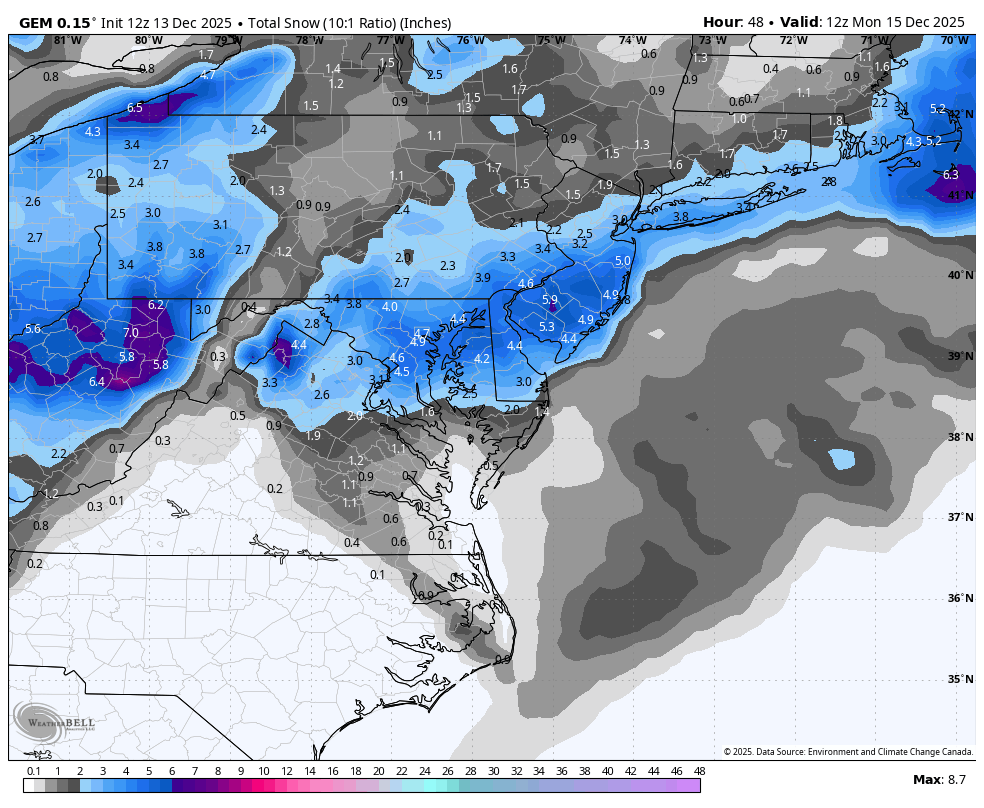
Canadian 12z ..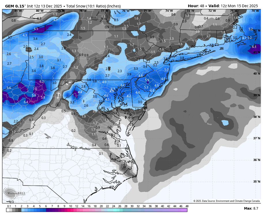
-
12/14: Sunday funday? Will the south win again?
winter_warlock replied to TSSN+'s topic in Mid Atlantic
Yeah just a bit lol -
12/14: Sunday funday? Will the south win again?
winter_warlock replied to TSSN+'s topic in Mid Atlantic
Central North Maryland may be entering warning criteria if this trend keeps up