

MickeyTim6533
-
Posts
275 -
Joined
-
Last visited
Content Type
Profiles
Blogs
Forums
American Weather
Media Demo
Store
Gallery
Everything posted by MickeyTim6533
-

E PA/NJ/DE Winter 2025-26 Obs/Discussion
MickeyTim6533 replied to LVblizzard's topic in Philadelphia Region

-
E PA/NJ/DE Winter 2025-26 Obs/Discussion
MickeyTim6533 replied to LVblizzard's topic in Philadelphia Region
tracking the rainstorm for thursday? nam says rain lol -
Central PA Winter 25/26 Discussion and Obs
MickeyTim6533 replied to MAG5035's topic in Upstate New York/Pennsylvania
Who's ready for Friday?? LOL -
Blizzard of 2026 Storm Thread/OBS
MickeyTim6533 replied to Mikeymac5306's topic in Philadelphia Region
more west than models showed? -
Blizzard of 2026 Storm Thread/OBS
MickeyTim6533 replied to Mikeymac5306's topic in Philadelphia Region
now that the snow has commenced, will the snow create its own cold air? -
Central PA Winter 25/26 Discussion and Obs
MickeyTim6533 replied to MAG5035's topic in Upstate New York/Pennsylvania
be careful the forum will call you a troll for voicing your opinion lol -
Blizzard of 2026 Storm Thread/OBS
MickeyTim6533 replied to Mikeymac5306's topic in Philadelphia Region
anyone have a good radar they use? -
Central PA Winter 25/26 Discussion and Obs
MickeyTim6533 replied to MAG5035's topic in Upstate New York/Pennsylvania
yep, the same NAM everyone was praising yesterday when it showed 2 feet -
Blizzard of 2026 Storm Thread/OBS
MickeyTim6533 replied to Mikeymac5306's topic in Philadelphia Region
although the NBM blend still looks good.'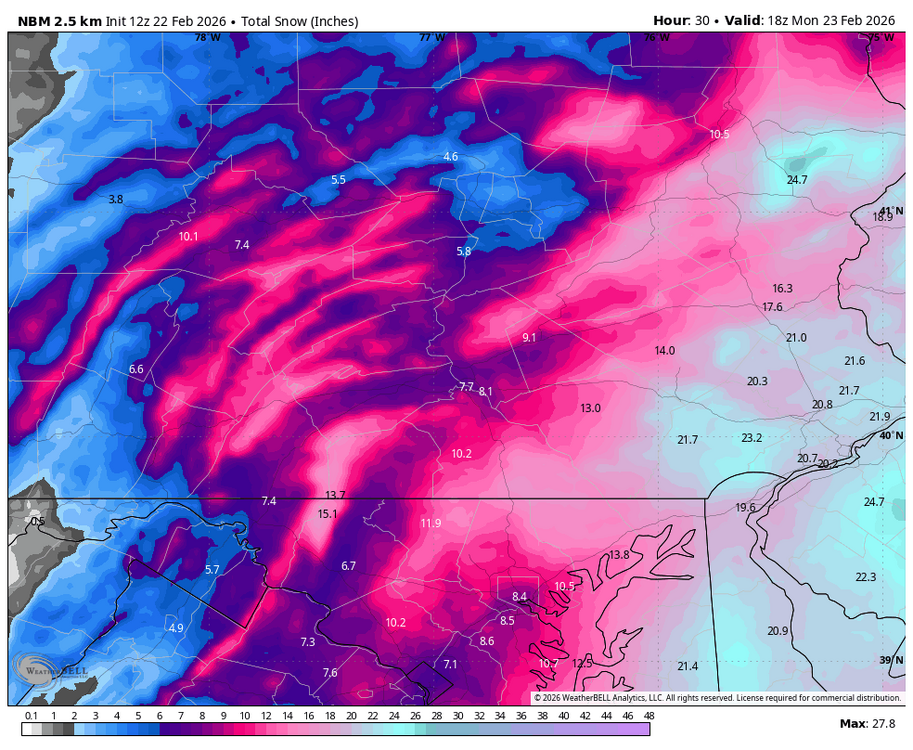
-
Blizzard of 2026 Storm Thread/OBS
MickeyTim6533 replied to Mikeymac5306's topic in Philadelphia Region
the east shift -
Blizzard of 2026 Storm Thread/OBS
MickeyTim6533 replied to Mikeymac5306's topic in Philadelphia Region
the models were "congrats" NJ all week -
Blizzard of 2026 Storm Thread/OBS
MickeyTim6533 replied to Mikeymac5306's topic in Philadelphia Region
sadly we all knew this east shift could happen -
Blizzard of 2026 Storm Thread/OBS
MickeyTim6533 replied to Mikeymac5306's topic in Philadelphia Region
ouch -
Blizzard of 2026 Storm Thread/OBS
MickeyTim6533 replied to Mikeymac5306's topic in Philadelphia Region
fooled by the gfs I guess, it did lead the way. -
Blizzard of 2026 Storm Thread/OBS
MickeyTim6533 replied to Mikeymac5306's topic in Philadelphia Region
yeah, major bust potential -
Blizzard of 2026 Storm Thread/OBS
MickeyTim6533 replied to Mikeymac5306's topic in Philadelphia Region
ouch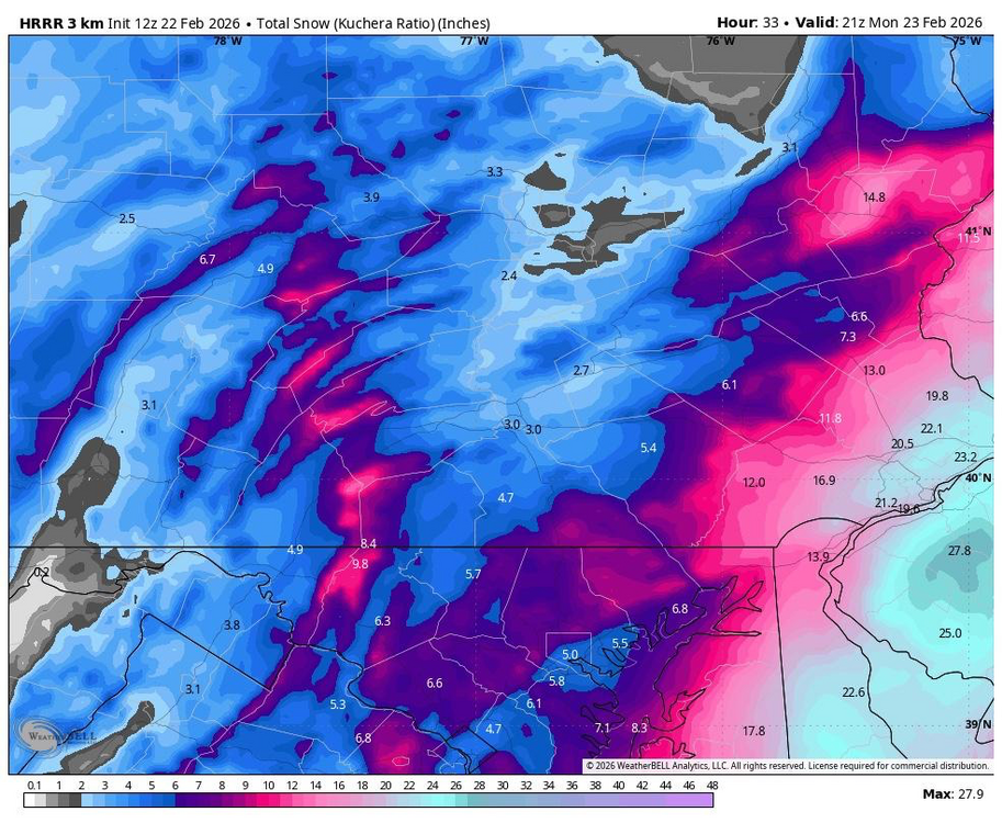
-
Blizzard of 2026 Storm Thread/OBS
MickeyTim6533 replied to Mikeymac5306's topic in Philadelphia Region
HRRR isn't really east, just weaker -
Blizzard of 2026 Storm Thread/OBS
MickeyTim6533 replied to Mikeymac5306's topic in Philadelphia Region
the RAP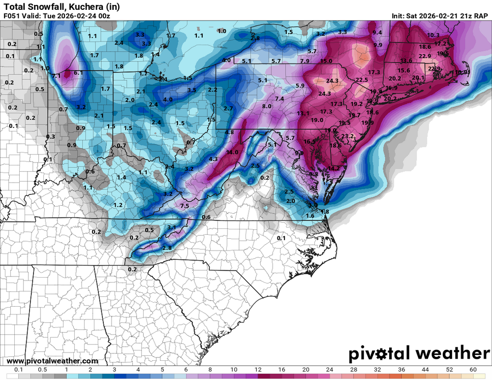
-
Blizzard of 2026 Storm Thread/OBS
MickeyTim6533 replied to Mikeymac5306's topic in Philadelphia Region
why worry bout the GFS now? the event is inside 36 hours now. its short term and meso models now -
Blizzard of 2026 Storm Thread/OBS
MickeyTim6533 replied to Mikeymac5306's topic in Philadelphia Region
does anyone think this will come even more west? -
Central PA Winter 25/26 Discussion and Obs
MickeyTim6533 replied to MAG5035's topic in Upstate New York/Pennsylvania
Winter Storm Warning Severity: Severe Significant threat to life or property Weather Event Onset 7:00 AM (EST), February 22 Description * WHAT...Heavy snow expected. Total snow accumulations between 8 and 16 inches. Winds gusting as high as 45 mph. * WHERE...Berks, Lehigh, Northampton, Carbon, and Monroe Counties. * WHEN...From 7 AM Sunday to 6 PM EST Monday. * IMPACTS...Travel could be very difficult to impossible. Some blowing snow is likely which could lead to reduced visibility. The hazardous conditions could impact the Monday morning and evening commutes. Gusty winds could bring down tree branches. Action Recommended Make preparations per the Description. Urgency Take action within next hour. Affected Area Berks Issued By National Weather Service -
Central PA Winter 25/26 Discussion and Obs
MickeyTim6533 replied to MAG5035's topic in Upstate New York/Pennsylvania
-
Blizzard of 2026 Storm Thread/OBS
MickeyTim6533 replied to Mikeymac5306's topic in Philadelphia Region
warnings hoisted. Winter Storm Warning Severity: Severe Significant threat to life or property Weather Event Onset 7:00 AM (EST), February 22 Description * WHAT...Heavy snow expected. Total snow accumulations between 8 and 16 inches. Winds gusting as high as 45 mph. * WHERE...Berks, Lehigh, Northampton, Carbon, and Monroe Counties. * WHEN...From 7 AM Sunday to 6 PM EST Monday. * IMPACTS...Travel could be very difficult to impossible. Some blowing snow is likely which could lead to reduced visibility. The hazardous conditions could impact the Monday morning and evening commutes. Gusty winds could bring down tree branches. Action Recommended Make preparations per the Description. Urgency Take action within next hour. Affected Area Berks Issued By National Weather Service -
Central PA Winter 25/26 Discussion and Obs
MickeyTim6533 replied to MAG5035's topic in Upstate New York/Pennsylvania
when does it run agin?


