TalcottWx
-
Posts
28,808 -
Joined
Content Type
Profiles
Blogs
Forums
American Weather
Media Demo
Store
Gallery
Everything posted by TalcottWx
-
 Not in love with this transition west of CT river. We will flip, but looks better over to Kevin.
 -
This wasn't issued until early this morning: URGENT - WINTER WEATHER MESSAGE National Weather Service Boston/Norton MA 337 AM EST Mon Jan 23 2023 CTZ002-232145- /O.EXB.KBOX.WW.Y.0005.000000T0000Z-230123T2200Z/ Hartford CT- Including the cities of Hartford and Windsor Locks 337 AM EST Mon Jan 23 2023 ...WINTER WEATHER ADVISORY IN EFFECT UNTIL 5 PM EST THIS AFTERNOON... * WHAT...Rain changing to snow late this morning and continuing into the afternoon, with accumulations of 1 to 4 inches, highest totals across northwest Hartford county, in the hilly terrain. * WHERE...Hartford County. * WHEN...Until 5 PM EST this afternoon. * IMPACTS...Plan on slippery road conditions. The hazardous conditions could impact the morning or evening commute. PRECAUTIONARY/PREPAREDNESS ACTIONS... Slow down and use caution while traveling.
-
Am I too far west? I'm like 8-10 miles NW of Hartford ish
-
34/32 rain
-
Rain snow mix.
-
33/32 now. R/s line actually appears to be collapsing a bit.
-
34/32 rain
-
Light snow, 38/31
-
If we don't get snow out of this, the winter blows.
-
Stay patient
-
Nightmare outcome here.
-
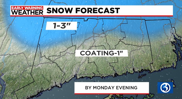
I'm cultured. Going on the record in this one and saying 1-3" forecast needs to come up we will bust high.
-
Wow. Peter was deleted. What does he do for a living?
-
Take them up I think.
-
3-6" please
-
There's a new Reverend in town I'll show u the way
-
All Hail TalcottWx
-
Let's snow bitches
-
Trying to keep the SNE enthusiasm alive.
-
39/36 light rain.
-
Meet you at Tree house
-
I don't use one. Only radarscope. Does anyone have a radar loop from 12/9/05?
-
I tried. Doug Flutie goes deep.
-
38/35 at home. Pathetic.