WeatherGeek2025
-
Posts
1,616 -
Joined
-
Last visited
Content Type
Profiles
Blogs
Forums
American Weather
Media Demo
Store
Gallery
Everything posted by WeatherGeek2025
-

Extreme Cold, Snow & Sleet: SECS 1/24 - 1/26
WeatherGeek2025 replied to TriPol's topic in New York City Metro
we hope for the CMC solution at this point I don't think any of us want mixing! -
Extreme Cold, Snow & Sleet: SECS 1/24 - 1/26
WeatherGeek2025 replied to TriPol's topic in New York City Metro
hey how far can this go? Will it hug, i'm guessing it won't cut but hugging is not out of the question right? -
Extreme Cold, Snow & Sleet: SECS 1/24 - 1/26
WeatherGeek2025 replied to TriPol's topic in New York City Metro
ukmet next -
Extreme Cold, Snow & Sleet: SECS 1/24 - 1/26
WeatherGeek2025 replied to TriPol's topic in New York City Metro
canadian shows snow from 7am sun to 7am monday no secondary low like last run great run but needs to stop the north jog here otherwise we'll smell sleet -
Extreme Cold, Snow & Sleet: SECS 1/24 - 1/26
WeatherGeek2025 replied to TriPol's topic in New York City Metro
wow man we need the north trend to stop -
Extreme Cold, Snow & Sleet: SECS 1/24 - 1/26
WeatherGeek2025 replied to TriPol's topic in New York City Metro
cmc huge hit -
Extreme Cold, Snow & Sleet: SECS 1/24 - 1/26
WeatherGeek2025 replied to TriPol's topic in New York City Metro
how about kuchera haha -
Extreme Cold, Snow & Sleet: SECS 1/24 - 1/26
WeatherGeek2025 replied to TriPol's topic in New York City Metro
it almost looks like ukmet, euro and cmc so far -
Extreme Cold, Snow & Sleet: SECS 1/24 - 1/26
WeatherGeek2025 replied to TriPol's topic in New York City Metro
0z vs 18z -
Extreme Cold, Snow & Sleet: SECS 1/24 - 1/26
WeatherGeek2025 replied to TriPol's topic in New York City Metro
there he is the old timer yanksfan wheres allsnow and juliancolton -
Extreme Cold, Snow & Sleet: SECS 1/24 - 1/26
WeatherGeek2025 replied to TriPol's topic in New York City Metro
@yanksfan and @allsnow used to do it and tony. used to be fun what happen to @Juliancolton -
Extreme Cold, Snow & Sleet: SECS 1/24 - 1/26
WeatherGeek2025 replied to TriPol's topic in New York City Metro
it's times like these that i don't mind going to work cause you know 12z runs is for tracking and than going home is 18z definitely making sure my phone is charged so i can track than i stay up late for the 0z runs and as soon as i wake up i check the 6z runs its a great hobby and its free -
Extreme Cold, Snow & Sleet: SECS 1/24 - 1/26
WeatherGeek2025 replied to TriPol's topic in New York City Metro
hoping that ice just keeps trending more north so we get more snow! -
Extreme Cold, Snow & Sleet: SECS 1/24 - 1/26
WeatherGeek2025 replied to TriPol's topic in New York City Metro
i think 15:1 sounds reasonable for the overrunning, if the coastal takes over than those will probably drop to around 12:1 or so! so figure 0.80 liquid on average 12-14 inches -
Extreme Cold, Snow & Sleet: SECS 1/24 - 1/26
WeatherGeek2025 replied to TriPol's topic in New York City Metro
Nam had us 15-20 range from 84 hours and on and kept depicting that north move every other model caved to it, GFS was last to cave! -
Extreme Cold, Snow & Sleet: SECS 1/24 - 1/26
WeatherGeek2025 replied to TriPol's topic in New York City Metro
early afternoon Sunday should be snowing 2pm or so! -
gfs is the most garbage model
-
Extreme Cold, Snow & Sleet: SECS 1/24 - 1/26
WeatherGeek2025 replied to TriPol's topic in New York City Metro
gfs catching up -
Extreme Cold, Snow & Sleet: SECS 1/24 - 1/26
WeatherGeek2025 replied to TriPol's topic in New York City Metro
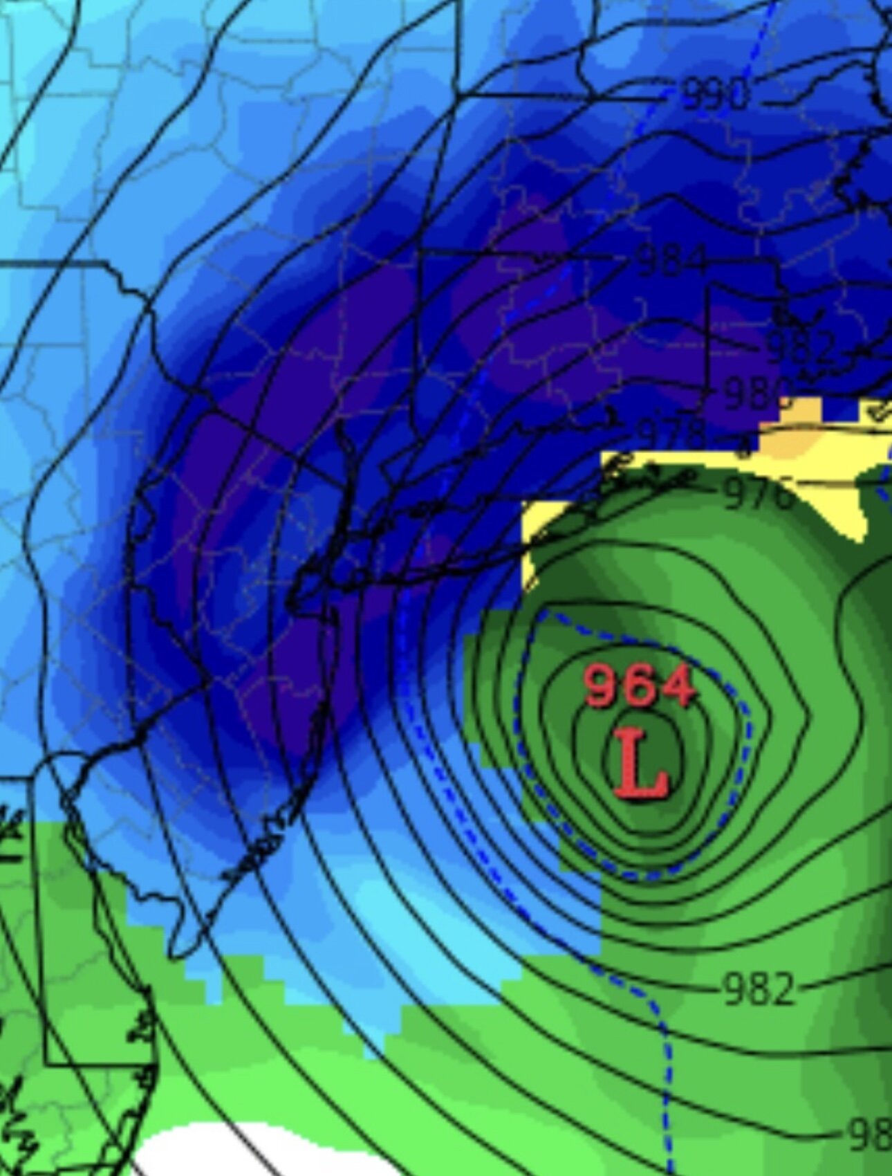
the low is ur right but the precip is a bit sharper and that's south. Good thing is the low is north and stronger that's what we need. sorry about that -
Extreme Cold, Snow & Sleet: SECS 1/24 - 1/26
WeatherGeek2025 replied to TriPol's topic in New York City Metro
Icon is a bit south probably around 30 miles or so! -
Extreme Cold, Snow & Sleet: SECS 1/24 - 1/26
WeatherGeek2025 replied to TriPol's topic in New York City Metro
that's not true, the GfS showed a storm last week and everyone discounted it ended up being half right but everyone said it wasn't worth looking at but gfs is a good model but i think its wrong here because you literally have the cmc uk and euro depicting a SECs -
Extreme Cold, Snow & Sleet: SECS 1/24 - 1/26
WeatherGeek2025 replied to TriPol's topic in New York City Metro
-
Extreme Cold, Snow & Sleet: SECS 1/24 - 1/26
WeatherGeek2025 replied to TriPol's topic in New York City Metro
it's a great run, everything else is noise -
Extreme Cold, Snow & Sleet: SECS 1/24 - 1/26
WeatherGeek2025 replied to TriPol's topic in New York City Metro
I like where we stand, i think the GFS will come around -
Extreme Cold, Snow & Sleet: SECS 1/24 - 1/26
WeatherGeek2025 replied to TriPol's topic in New York City Metro
i said i would step away from posting for 48 hours if we didn't see a north trend from the models last night and we did so in here


