WeatherGeek2025
-
Posts
1,616 -
Joined
-
Last visited
Content Type
Profiles
Blogs
Forums
American Weather
Media Demo
Store
Gallery
Everything posted by WeatherGeek2025
-

Extreme Cold, Snow & Sleet: SECS 1/24 - 1/26
WeatherGeek2025 replied to TriPol's topic in New York City Metro
NAM sucks! I would toss but yes we will sleet maybe up to White Plains and than that sleet line will collapse again! -
Extreme Cold, Snow & Sleet: SECS 1/24 - 1/26
WeatherGeek2025 replied to TriPol's topic in New York City Metro
no dude it'll be snowing heavily all day tomorrow! changing to sleet north of let's say Mahopac it'll stay all snow! It's going to be an over performer in my opinion people are going to be thinking all the sleet meanwhile the thump will overperform and stack -
“Cory’s in LA! Let’s MECS!” Jan. 24-26 Disco
WeatherGeek2025 replied to TheSnowman's topic in New England
Boston Jax? -
Extreme Cold, Snow & Sleet: SECS 1/24 - 1/26
WeatherGeek2025 replied to TriPol's topic in New York City Metro
6-10 inches by followed by 2 inches of sleet! this snow will last into March lol Sleet is happening we got consensus now we have to just look at radar and nowcast -
Extreme Cold, Snow & Sleet: SECS 1/24 - 1/26
WeatherGeek2025 replied to TriPol's topic in New York City Metro
i doubt that reaches the ground, it's very dry. I'd say 7am start time in the city proper -
Extreme Cold, Snow & Sleet: SECS 1/24 - 1/26
WeatherGeek2025 replied to TriPol's topic in New York City Metro
reggie and gfs next -
Extreme Cold, Snow & Sleet: SECS 1/24 - 1/26
WeatherGeek2025 replied to TriPol's topic in New York City Metro
unreliable model -
Extreme Cold, Snow & Sleet: SECS 1/24 - 1/26
WeatherGeek2025 replied to TriPol's topic in New York City Metro
i gotta revise my snowmap and my snow prediction, lowering by 40% -
“Cory’s in LA! Let’s MECS!” Jan. 24-26 Disco
WeatherGeek2025 replied to TheSnowman's topic in New England
i feel like the sleet line will fight off with snow line around maybe a few miles north of Tom's River, NJ -
“Cory’s in LA! Let’s MECS!” Jan. 24-26 Disco
WeatherGeek2025 replied to TheSnowman's topic in New England
both of these will end up wrong, go with the middle -
Extreme Cold, Snow & Sleet: SECS 1/24 - 1/26
WeatherGeek2025 replied to TriPol's topic in New York City Metro
-
“Cory’s in LA! Let’s MECS!” Jan. 24-26 Disco
WeatherGeek2025 replied to TheSnowman's topic in New England
okay i'll text you here monday and see who was wrong. I can be wrong im not saying that but im not falling for a crappy model thats getting retired! Yes we will mix with some sleet but that sleet line will drop south immediately once the low pressure starts taking shape off the coast of Jersey -
“Cory’s in LA! Let’s MECS!” Jan. 24-26 Disco
WeatherGeek2025 replied to TheSnowman's topic in New England
Nam doesn't have strengths we've been through this before! Nam is literally the worst model and they're retiring it for a reason. HRRR is the model to use and rap -
“Cory’s in LA! Let’s MECS!” Jan. 24-26 Disco
WeatherGeek2025 replied to TheSnowman's topic in New England
i'm north of the city, I think NAM is on crack -
“Cory’s in LA! Let’s MECS!” Jan. 24-26 Disco
WeatherGeek2025 replied to TheSnowman's topic in New England
Nam vs Euro -
Extreme Cold, Snow & Sleet: SECS 1/24 - 1/26
WeatherGeek2025 replied to TriPol's topic in New York City Metro
not even close -
Extreme Cold, Snow & Sleet: SECS 1/24 - 1/26
WeatherGeek2025 replied to TriPol's topic in New York City Metro
i'd go with HRRR for the storm totals! Looks like a foot of snow is common around the area and yes maybe i'm being aggressive but NAM is being retired for a reason! -
Extreme Cold, Snow & Sleet: SECS 1/24 - 1/26
WeatherGeek2025 replied to TriPol's topic in New York City Metro
NAm sucks, there's not going to be sleet in mountain creek NJ, lets be real here, nam is wrong! -
Extreme Cold, Snow & Sleet: SECS 1/24 - 1/26
WeatherGeek2025 replied to TriPol's topic in New York City Metro
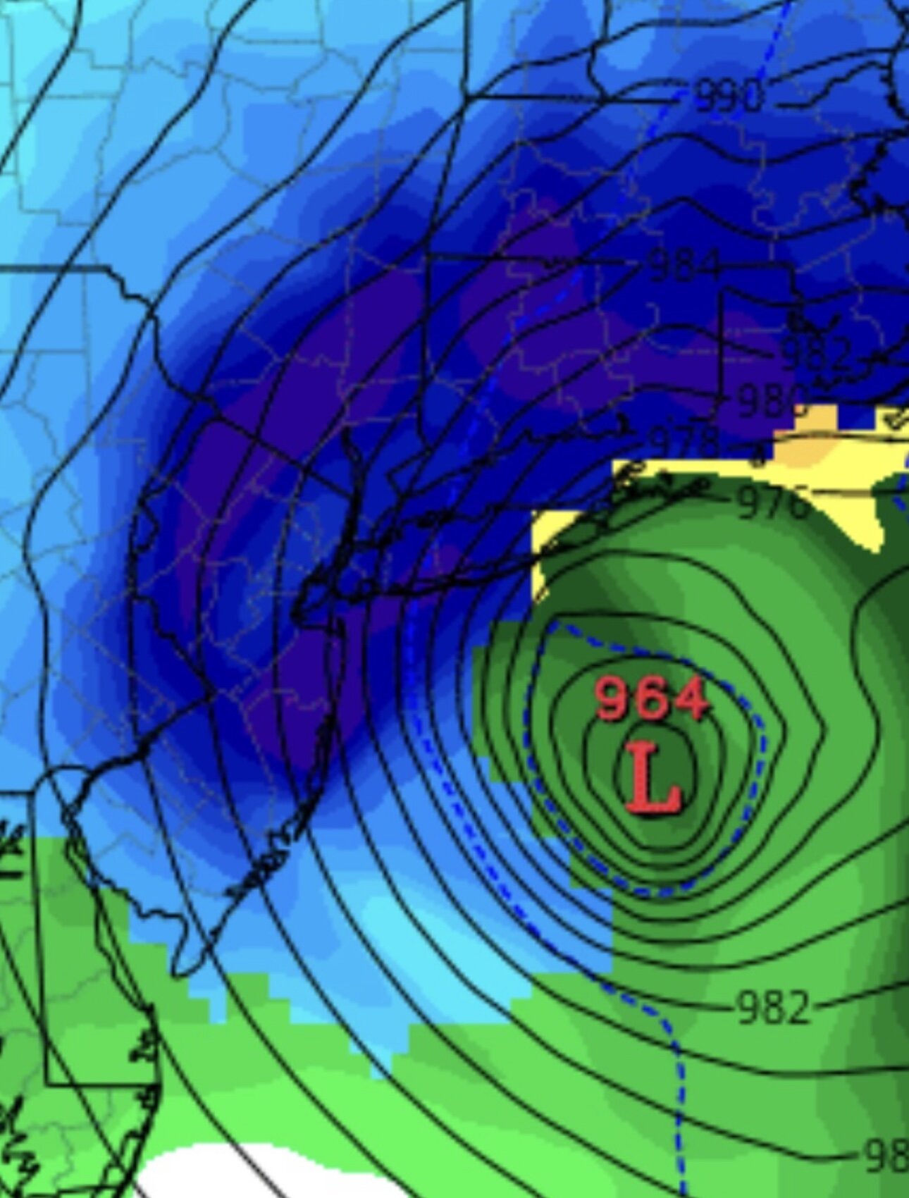
stole it from NE -
Extreme Cold, Snow & Sleet: SECS 1/24 - 1/26
WeatherGeek2025 replied to TriPol's topic in New York City Metro
hrrr looks good barely mixed at the end -
Extreme Cold, Snow & Sleet: SECS 1/24 - 1/26
WeatherGeek2025 replied to TriPol's topic in New York City Metro
is it better for the city? -
Extreme Cold, Snow & Sleet: SECS 1/24 - 1/26
WeatherGeek2025 replied to TriPol's topic in New York City Metro
Grab a small wrench and tap it numerous times. Like actually hit it -
Extreme Cold, Snow & Sleet: SECS 1/24 - 1/26
WeatherGeek2025 replied to TriPol's topic in New York City Metro
it was there rap 09z run looks cold!!! -
Extreme Cold, Snow & Sleet: SECS 1/24 - 1/26
WeatherGeek2025 replied to TriPol's topic in New York City Metro
where can i find this models radar composite? -
Extreme Cold, Snow & Sleet: SECS 1/24 - 1/26
WeatherGeek2025 replied to TriPol's topic in New York City Metro
hrrr is the best short term model and it looks perfect hope it's right.


