simbasad2
-
Posts
41 -
Joined
-
Last visited
About simbasad2

- Birthday June 16
-
E PA/NJ/DE Spring 2026 Obs/Discussion
simbasad2 replied to PhiEaglesfan712's topic in Philadelphia Region
Surprised nobody is mentioning the potential severe weather activity on Day-4 -
E PA/NJ/DE Winter 2025-26 Obs/Discussion
simbasad2 replied to LVblizzard's topic in Philadelphia Region
Temperatures downtrended at the last minute. Undermodeled CAD, as always.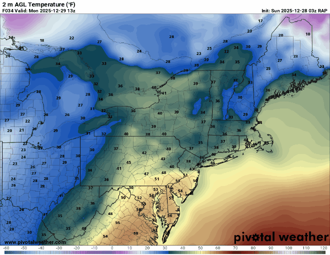
-
E PA/NJ/DE Winter 2025-26 Obs/Discussion
simbasad2 replied to LVblizzard's topic in Philadelphia Region
For the rain total folks, I'm at 0.07" on the day in West Chester, PA. Line looks like it's about done moving through, so that's probably about where I'll finish. I'll have an update if I record more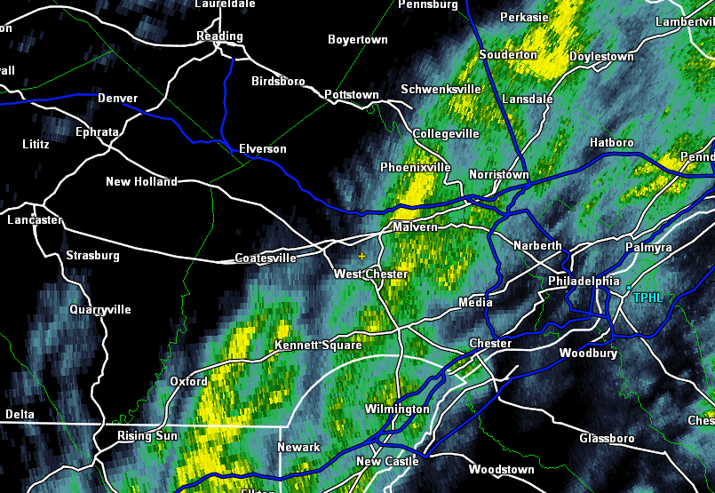
-
E PA/NJ/DE Winter 2025-26 Obs/Discussion
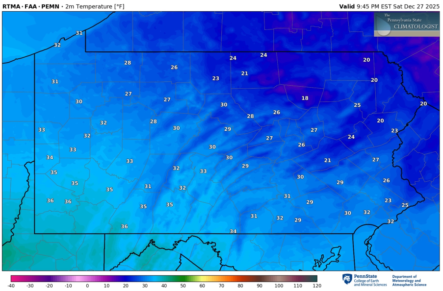
simbasad2 replied to LVblizzard's topic in Philadelphia Region
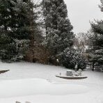
Very low flow at 925mb has allowed for a near-stationary low-level cloud deck to develop. This is reflecting on the temp maps, where it is in the low 20s near Philadelphia and Bucks county, but holding around 30 degrees here in Chester County. Neat stuff
-
Saturday night/Sunday 12/13-12/14 Jawn
simbasad2 replied to Ralph Wiggum's topic in Philadelphia Region
Agreed. Was originally thinking that it was going to be in South Jersey but overnight guidance has lead me to believe it'll be somewhere right along I-95. -
Saturday night/Sunday 12/13-12/14 Jawn
simbasad2 replied to Ralph Wiggum's topic in Philadelphia Region
What the hell is this 00z NAM lmfao... I think this solution is unlikely at the moment so this doesn't worry me, but this is a really funny snow map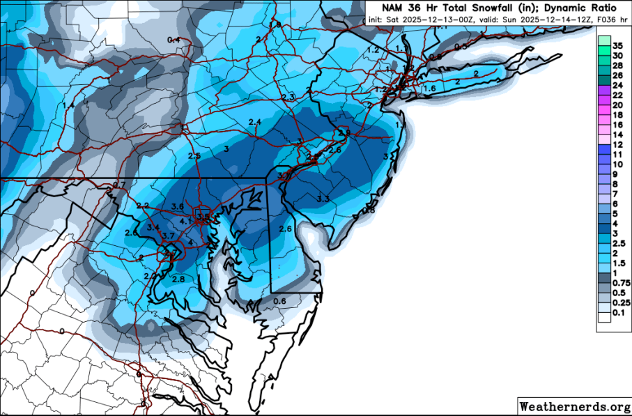
-
Saturday night/Sunday 12/13-12/14 Jawn
simbasad2 replied to Ralph Wiggum's topic in Philadelphia Region
Here's my first call, going a little bit on the aggressive side with the band that sets up over I-95. I think that the regional models (NAM/RDPS/RRFS etc..) have a better handling on how this storm will do has there will be important mesoscale features determining total snowfall that the global models just aren't able to resolve. My thinking is that hypothetically if the banding can really get going along I-95 then NW and SE areas wouldn't do as well because of the subsidence that would result -
Saturday night/Sunday 12/13-12/14 Jawn
simbasad2 replied to Ralph Wiggum's topic in Philadelphia Region
Created sort of a "0.5th call" as we approach around 60 hours from precipitation onset. Don't pay attention to the numbers on the side (I even crossed it out) just focus on the shade of the color. While not a full forecast, it does outline some aspects of my thoughts such as 1. Snow more favored for I-95 and surrounding suburbs, but slightly less confidence as you travel northbound on I-95 closer to NYC 2. Snow less likely as you head towards the far northwest suburbs and the shore 3. Despite these differences, the entire map is shaded as I think this will be an event where everyone in the region has a very good shot at getting some sort of snowfall -
12/3 Snow/Sleet/Mix Bag of Everything Discussion/OBS
simbasad2 replied to Mikeymac5306's topic in Philadelphia Region
Measured 0.2" of snow/sleet/slush this morning. Though, this was after the changeover, so it's possible there was more that was melted -
12/3 Snow/Sleet/Mix Bag of Everything Discussion/OBS
simbasad2 replied to Mikeymac5306's topic in Philadelphia Region
Final call for this storm, shifting everything to the north and west by a ton. The storm keeps trending slower and slower AND warmer, both horrible for our storm for everyone. I'm thinking I-95 will start as a wintery mix and areas just NW of 95 will start as some flakes before quickly shifting over. Far NW suburbs + mountains will still likely see some decent accumulations, but I removed the 6-8 contour for the poconos as totals downtrend even for up there. Schuylkill, Carbon, and Monroe counties are the only areas on this map that will remain all snow. Still can't rule out isolated 6"+ for those areas but not widespread enough to add the 6-8 contour back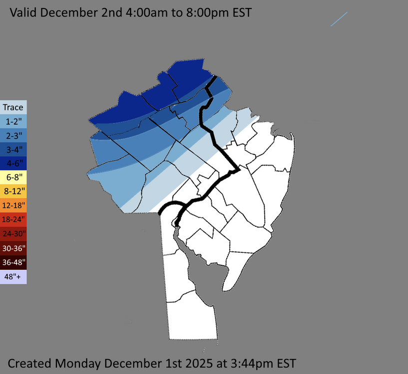
-
12/3 Snow/Sleet/Mix Bag of Everything Discussion/OBS
simbasad2 replied to Mikeymac5306's topic in Philadelphia Region
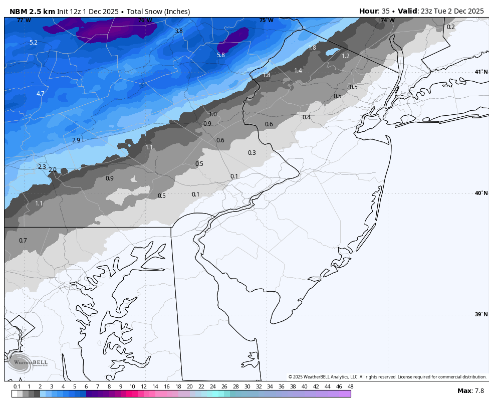
I'm really disliking the overnight trends for I-95 and the immediate suburbs. 12z NBM has literally no snowfall for the entire urban corridor (Eastern Chester, Eastern Montgomery, Lower Bucks NWS forecast zones and points SE). This storm is reminding me of the one we had around this time in December 2019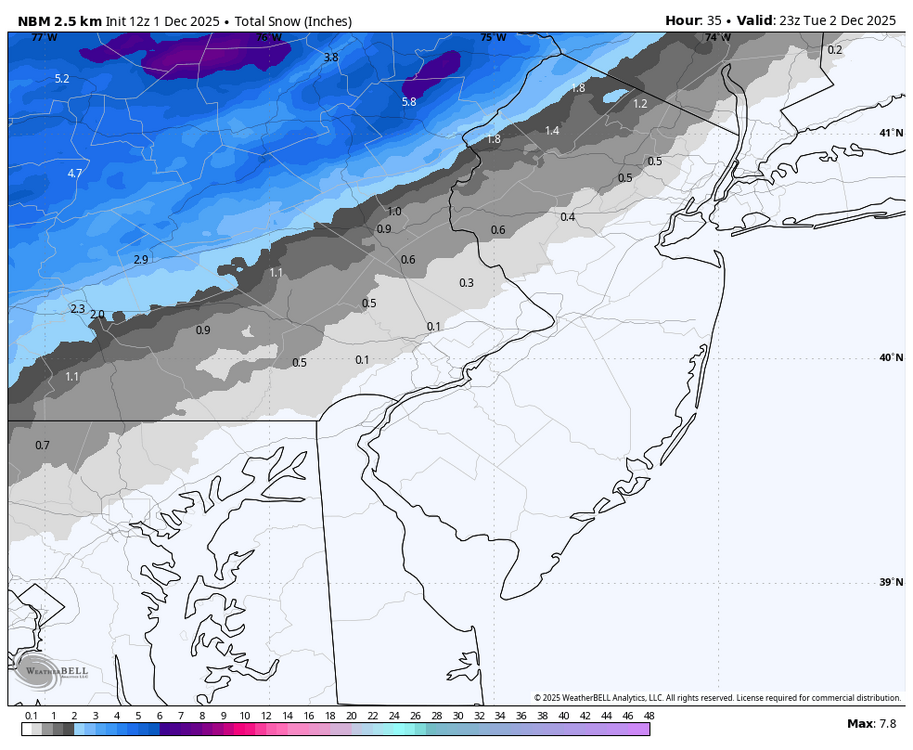
-
E PA/NJ/DE Winter 2025-26 Obs/Discussion
simbasad2 replied to LVblizzard's topic in Philadelphia Region
Thank you!! -
12/3 Snow/Sleet/Mix Bag of Everything Discussion/OBS
simbasad2 replied to Mikeymac5306's topic in Philadelphia Region
Reposting this here -
E PA/NJ/DE Winter 2025-26 Obs/Discussion
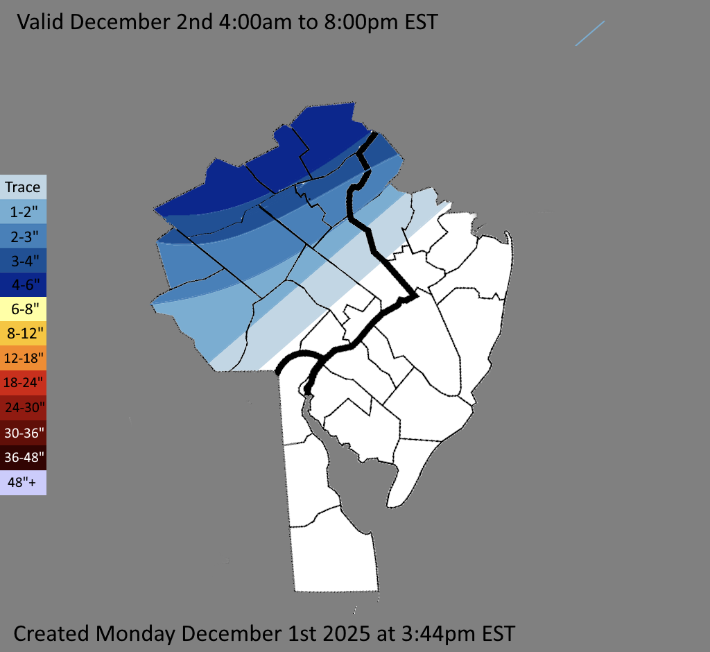
simbasad2 replied to LVblizzard's topic in Philadelphia Region
Here are my thoughts regarding totals for the region for Tuesday. Keeping the heavier snow to the northwest with a sharp gradient as you approach I-95. I'm thinking I might shift this even farther northwest in future updates but we'll see -
E PA/NJ/DE Autumn 2025 Obs/Discussion
simbasad2 replied to PhiEaglesfan712's topic in Philadelphia Region
All the other regional sub forums have done it, I think a board for the December 2nd storm should be created sometime today or tomorrow