Cabby
-
Posts
4 -
Joined
-
Last visited
Content Type
Profiles
Blogs
Forums
American Weather
Media Demo
Store
Gallery
Everything posted by Cabby
-
Upgraded to WSW for some areas URGENT - WINTER WEATHER MESSAGE National Weather Service Morristown TN 1225 AM EST Wed Jan 14 2026 TNZ041-072-074-141800- /O.UPG.KMRX.WW.Y.0001.260114T2000Z-260115T1600Z/ /O.NEW.KMRX.WS.W.0001.260114T2000Z-260115T1600Z/ Cocke Smoky Mountains-Blount Smoky Mountains-Sevier Smoky Mountains- Including the cities of Gatlinburg, Elkmont, Cades Cove, and Hartford 1225 AM EST Wed Jan 14 2026 ...WINTER STORM WARNING IN EFFECT FROM 3 PM THIS AFTERNOON TO 11 AM EST THURSDAY... * WHAT...Heavy snow expected. Total snow accumulations of 4 to 8 inches, mainly at or above 3000 feet in elevation. Locally higher amounts of 10 inches or more are expected along the highest peaks. Winds gusting as high as 40 mph. * WHERE...Blount Smoky Mountains, Cocke Smoky Mountains, and Sevier Smoky Mountains Counties. * WHEN...From 3 PM this afternoon to 11 AM EST Thursday. * IMPACTS...Travel could be very difficult. The hazardous conditions could impact the Wednesday evening and Thursday morning commutes. PRECAUTIONARY/PREPAREDNESS ACTIONS... If you must travel, keep an extra flashlight, food, and water in your vehicle in case of an emergency. The latest road conditions for the state you are calling from can be obtained by calling 5 1 1.
-
URGENT - WINTER WEATHER MESSAGE National Weather Service Morristown TN 1129 AM EST Tue Jan 13 2026 TNZ018-041-043-045-047-072-074-087-140800- /O.NEW.KMRX.WW.Y.0001.260114T2000Z-260115T1600Z/ Johnson-Cocke Smoky Mountains-Southeast Greene-Unicoi-Southeast Carter-Blount Smoky Mountains-Sevier Smoky Mountains-Southeast Monroe- Including the cities of Doeville, Laurel Bloomery, Citico, Gatlinburg, Mountain City, Neva, Unicoi, Cades Cove, Elkmont, Shady Valley, Limestone Cove, Hartford, Hampton, Cedar Creek, Trade, Erwin, and Coker Creek 1129 AM EST Tue Jan 13 2026 ...WINTER WEATHER ADVISORY IN EFFECT FROM 3 PM WEDNESDAY TO 11 AM EST THURSDAY... * WHAT...Snow expected. Total snow accumulations of 2 to 4 inches, but up to 6 inches for elevations above 5000 feet. Winds gusting as high as 40 mph. * WHERE...A portion of east Tennessee. * WHEN...From 3 PM Wednesday to 11 AM EST Thursday.
-
peek-a-boo....
-
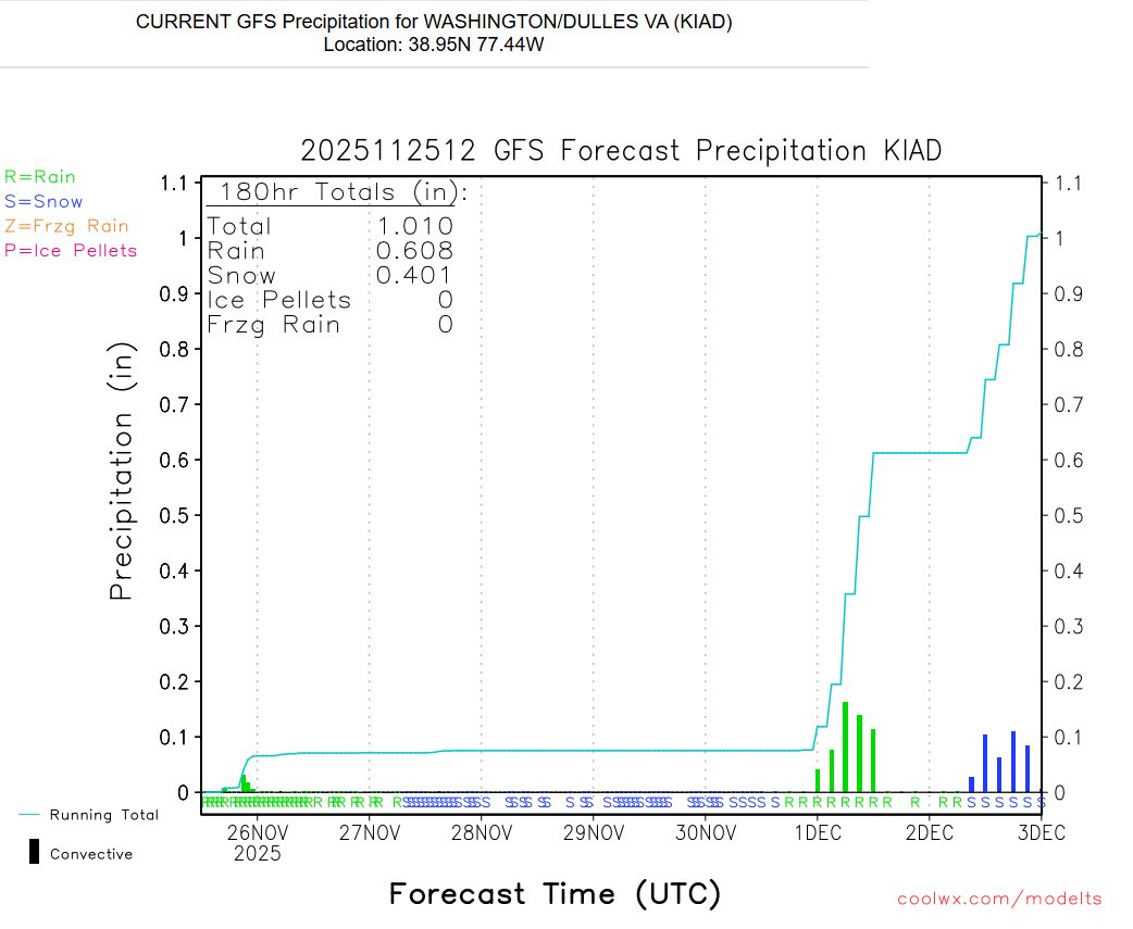
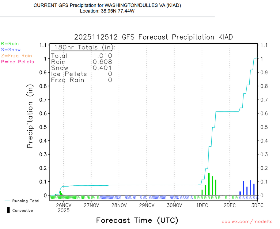
Found out some sad weather news today.... Coolwx.com is shutting it down (temporarily?) apparently due to recent political happenings. https://coolwx.com/ I've used this site for literally decades every day, and gotten to know the owner over the years through email, so these are indeed sad times. The 2/27/25 18Z run may be it's last update.... https://coolwx.com/cgi-bin/getbufr.cgi?region=FL&stn=KJAX&model=gfs&time=current&field=prec - stuck here forever, sucks...