

Ericjcrash
-
Posts
5,529 -
Joined
-
Last visited
Content Type
Profiles
Blogs
Forums
American Weather
Media Demo
Store
Gallery
Everything posted by Ericjcrash
-
Weirdly sometimes the wind is westerly. Heavy dust continues to fall.
-
They had snow earlier too. I'd say it was decent day there. Maybe not all that white, but wild.
-
Waterspouts Jersey coast too.
-
"Only" lol.
-
Cut off back to 0z
-
Heavy dust now. If there was any snowgrowth at all this would be great.
-
Just completely busted my ass, all sidewalks have been skating rinks since last Sunday and I completely forgot. The 2" of dust masked that and I went down hard. Turned it around. Winds are picking up
-
Technically moderate, almost heavy snow but it's just dust that isn't adding up to much lol.
-
Moderate dust, picking up intensity.
-
Congrats guys, what a band!
-
Same. Good luck. The NAMs UK and Euro have really improved for us. Let's see how it plays out. And that band in the SW corner of the state wow
-
Widespread Snow Potential January 16th to January 18th
Ericjcrash replied to sferic's topic in Upstate New York/Pennsylvania
GFS is locked and loaded. Over an inch QPF as snow here. Good luck to all, warm layer be damned. -
Widespread Snow Potential January 16th to January 18th
Ericjcrash replied to sferic's topic in Upstate New York/Pennsylvania
Euro and UK really going up here. Getting jucier and juicier. -
Widespread Snow Potential January 16th to January 18th
Ericjcrash replied to sferic's topic in Upstate New York/Pennsylvania
Things are looking up. -
Widespread Snow Potential January 16th to January 18th
Ericjcrash replied to sferic's topic in Upstate New York/Pennsylvania
Pretty much all guidance has spread the QPF out more evenly over the state the past day or so. We all win. -
Widespread Snow Potential January 16th to January 18th
Ericjcrash replied to sferic's topic in Upstate New York/Pennsylvania
Definitely jogged SE at 12z -
Few little bands headed to Mobile and FL panhandle.
-
Widespread Snow Potential January 16th to January 18th
Ericjcrash replied to sferic's topic in Upstate New York/Pennsylvania
Everyone must be passed out drunk from the Bill's game -
Widespread Snow Potential January 16th to January 18th
Ericjcrash replied to sferic's topic in Upstate New York/Pennsylvania
Euro is excellent. I'll sign the contract.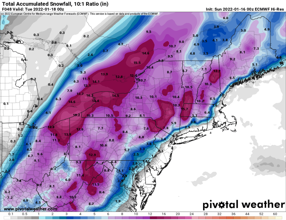
-
-5° moonlight is remarkable Brrrr
-
Widespread Snow Potential January 16th to January 18th
Ericjcrash replied to sferic's topic in Upstate New York/Pennsylvania
I'm a fan. I'm a big fan. Excellent uptick here this evening. -
Widespread Snow Potential January 16th to January 18th
Ericjcrash replied to sferic's topic in Upstate New York/Pennsylvania
I hope the king regains his throne for this event. -
Widespread Snow Potential January 16th to January 18th
Ericjcrash replied to sferic's topic in Upstate New York/Pennsylvania
You usually do pretty well. Let's hope for the best -
Widespread Snow Potential January 16th to January 18th
Ericjcrash replied to sferic's topic in Upstate New York/Pennsylvania
The NAM is a shit model as is the ARW. They both are extreme outliers in opposite directions and should both be tossed until theres supports. -
Widespread Snow Potential January 16th to January 18th
Ericjcrash replied to sferic's topic in Upstate New York/Pennsylvania
116 PM EST Sat Jan 15 2022 ...WINTER STORM WATCH REMAINS IN EFFECT FROM SUNDAY EVENING THROUGH MONDAY EVENING... * WHAT...Heavy snow and mixed precipitation are potentially possible. Total snow and sleet accumulations of 4 to 12 inches and ice accumulations of a light glaze possible. Winds could gust to 40 to 50 mph over the higher terrain. * WHERE...Southern Vermont, southern Adirondacks, Mohawk Valley, eastern Catskills, Helderbergs and the Lake George northern Saratoga Region and Schoharie Valley in eastern New York and the Berkshires of western Massachusetts. AKA we don't know if the NAM or Euro is right.


