.webp.70c18861c39c8ef8c4811e598978da45.webp)

CurlyHeadBarrett
-
Posts
827 -
Joined
-
Last visited
Content Type
Profiles
Blogs
Forums
American Weather
Media Demo
Store
Gallery
Everything posted by CurlyHeadBarrett
-

2024 Atlantic Hurricane Season
CurlyHeadBarrett replied to Stormchaserchuck1's topic in Tropical Headquarters
Is it because Beryl sucked out all the hot water -
2024 Atlantic Hurricane Season
CurlyHeadBarrett replied to Stormchaserchuck1's topic in Tropical Headquarters
Atlantic needs a big rest I’m a bit lost here -
2024 Atlantic Hurricane Season
CurlyHeadBarrett replied to Stormchaserchuck1's topic in Tropical Headquarters
Lorenzo? I thought he went to Europe -
Hunters penetrating Beryl


-
150mph 950 now
-
Unreal now the EWRC has finished. She could make a run for a high 4. I’m worried for residents.
-
Tropical Storm Chris—40mph/1005mb
CurlyHeadBarrett replied to WxWatcher007's topic in Tropical Headquarters
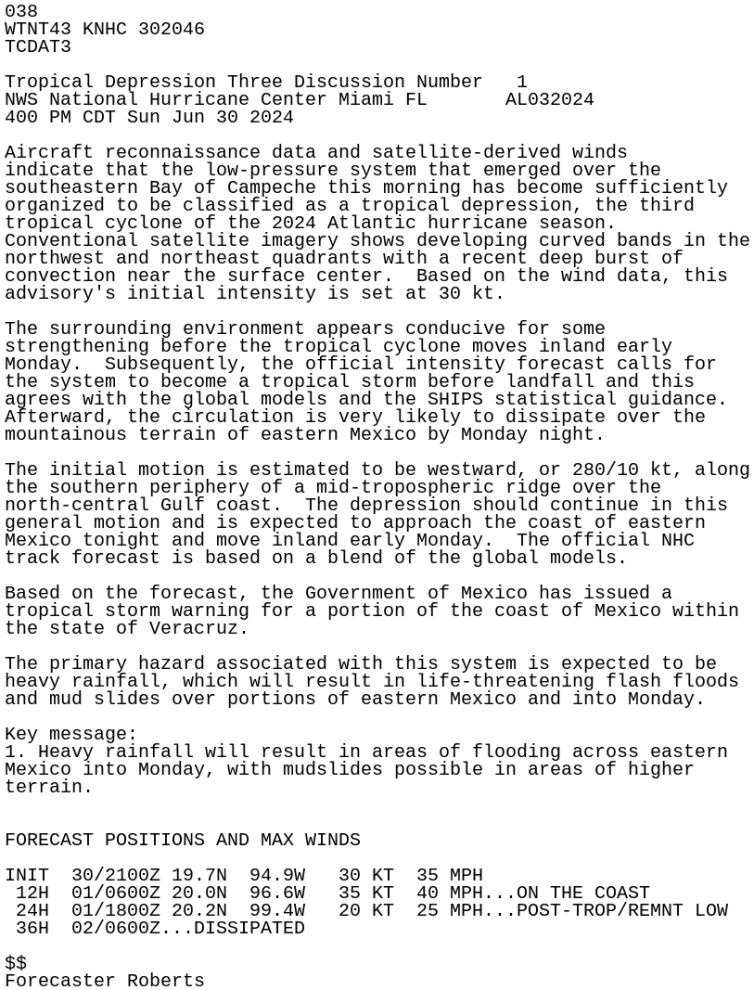
And now TD3 is officially declared on the NHC page TROPICAL DEPRESSION THREE FORECAST/ADVISORY NUMBER 1 NWS NATIONAL HURRICANE CENTER MIAMI FL AL032024 2100 UTC SUN JUN 30 2024
-
Tropical Storm Chris—40mph/1005mb
CurlyHeadBarrett replied to WxWatcher007's topic in Tropical Headquarters
Who deleted my last post, it was official information from NOAA. From the link posted. AL, 94, 2024063018, , BEST, 0, 196N, 944W, 30, 1007, TD https://ftp.nhc.noaa.gov/atcf/btk/bal942024.dat -
Tropical Storm Chris—40mph/1005mb
CurlyHeadBarrett replied to WxWatcher007's topic in Tropical Headquarters
1. Southwestern Gulf of Mexico (AL94): Satellite derived winds and preliminary aircraft reconnaissance data indicate that the area of low pressure located over the southern portion of the Bay of Campeche has become better organized during the past few hours and a tropical depression could be forming. The system is moving toward west-northwestward at 10 to 15 mph and is expected to approach the eastern coast of Mexico tonight and move inland on Monday morning. Consequently, a Tropical Storm Watch may be required later today for a portion of the eastern coast of Mexico. Interests along the Gulf Coast of Mexico should monitor the progress of this system. Regardless of development, heavy rainfall will result in areas of flooding across eastern Mexico today and into Monday, with mudslides possible in areas of higher terrain. An Air Force reconnaissance aircraft is currently investigating the system. * Formation chance through 48 hours...high...80 percent. * Formation chance through 7 days...high...80 percent. -
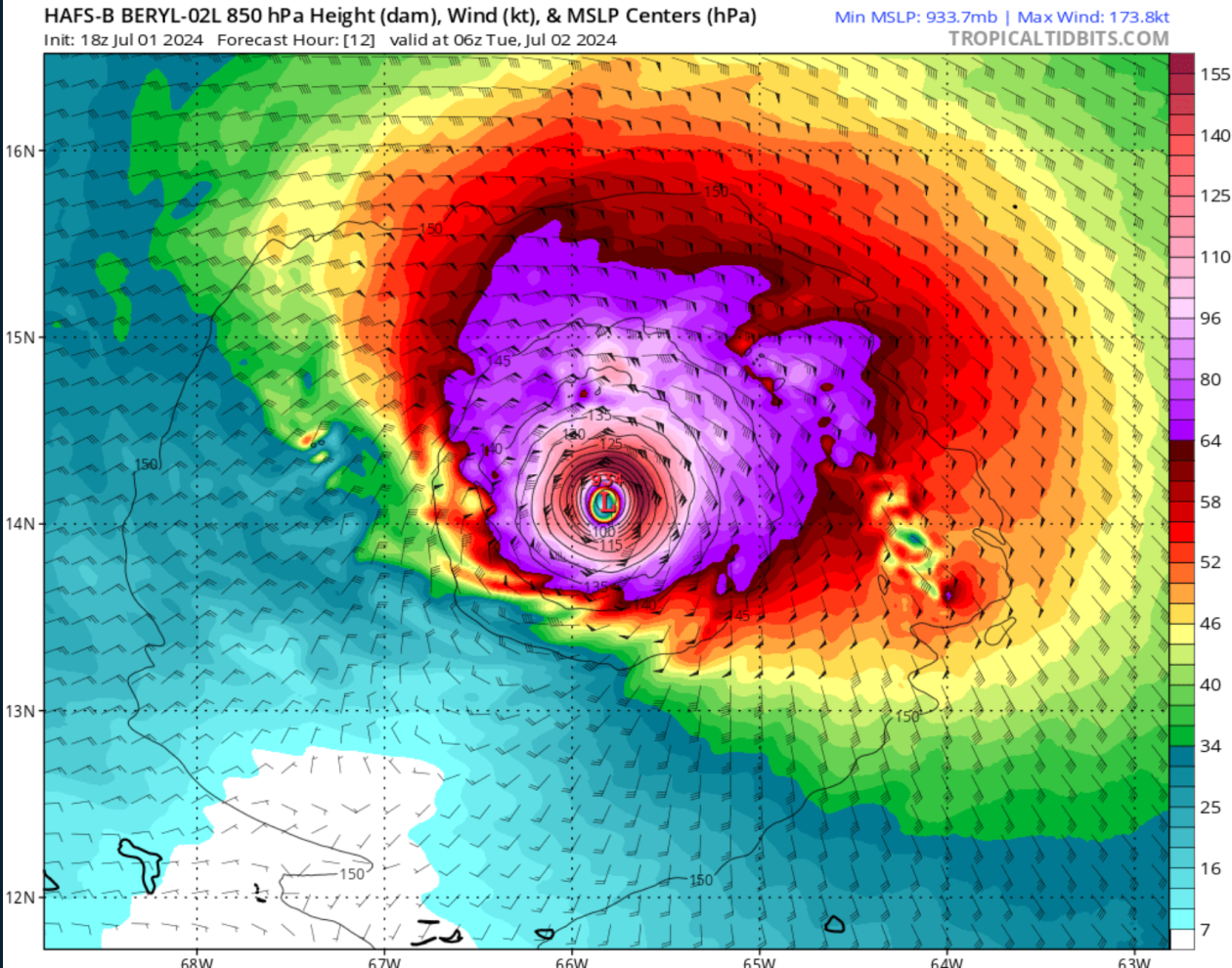
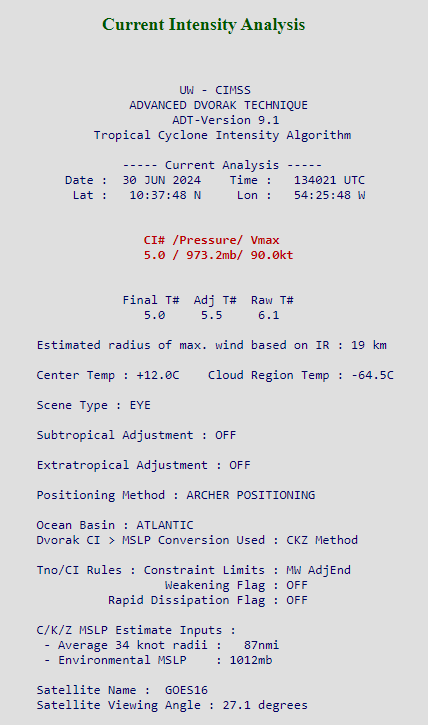
Now 120 Hurricane Beryl Satellite | Buoys | Grids | Storm Archive ...VERY DANGEROUS MAJOR HURRICANE BERYL STILL STRENGTHENING AS IT APPROACHES THE WINDWARD ISLANDS... ...LIFE-THREATENING WINDS AND STORM SURGE EXPECTED THERE BEGINNING EARLY MONDAY MORNING... 11:00 AM AST Sun Jun 30 Location: 10.7°N 54.9°W Moving: W at 21 mph Min pressure: 964 mb Max sustained: 120 mph Public Advisory #8 1100 AM AST
-
I predict 140
-
Just found this on twitter but it’s unofficial I REPEAT THIS IS UNOFFICIAL! we don't have any recon evidence showing it a cat 4 nor it rapidly intensifying right now
-
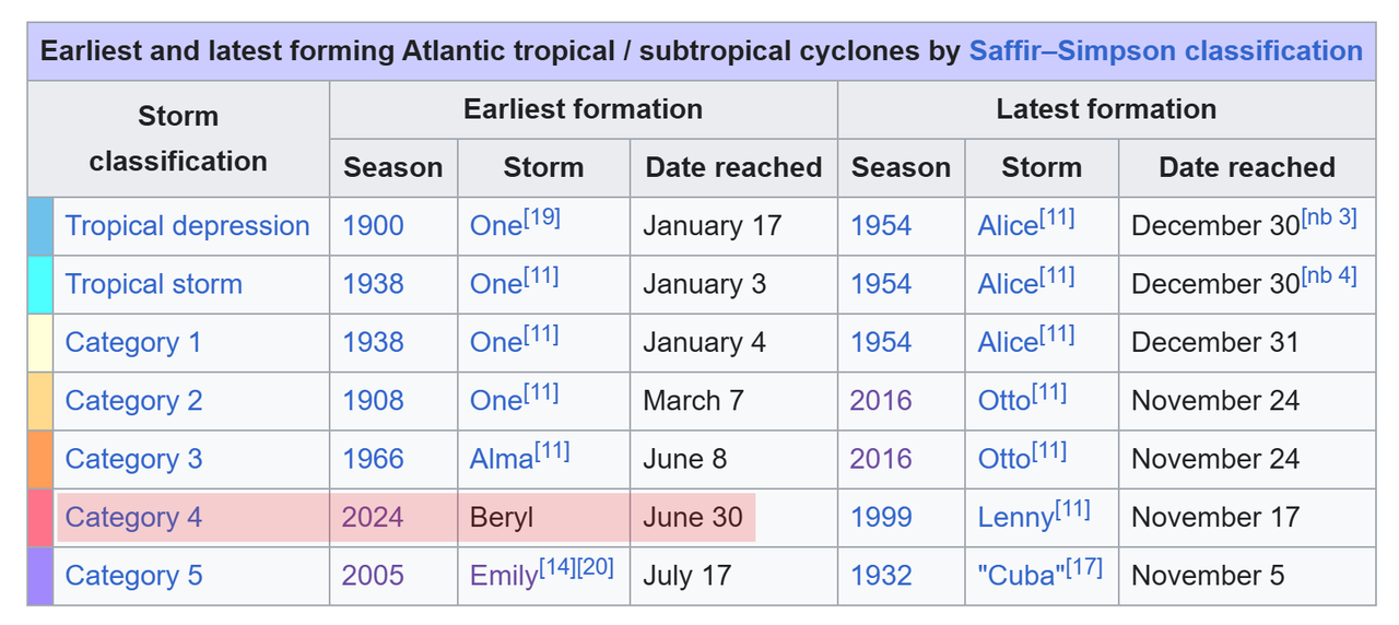
Translation: lol, Beryl has beaten up the other June named storms to dust. she will be the bar for all future early season storms
-
Chris or Debby?
-
Tropical Storm Chris—40mph/1005mb
CurlyHeadBarrett replied to WxWatcher007's topic in Tropical Headquarters
Do you think this will take Chris or Debby -
2024 Atlantic Hurricane Season
CurlyHeadBarrett replied to Stormchaserchuck1's topic in Tropical Headquarters
Lifefuel for Mexico City residents