.webp.70c18861c39c8ef8c4811e598978da45.webp)

CurlyHeadBarrett
-
Posts
827 -
Joined
-
Last visited
Content Type
Profiles
Blogs
Forums
American Weather
Media Demo
Store
Gallery
Everything posted by CurlyHeadBarrett
-
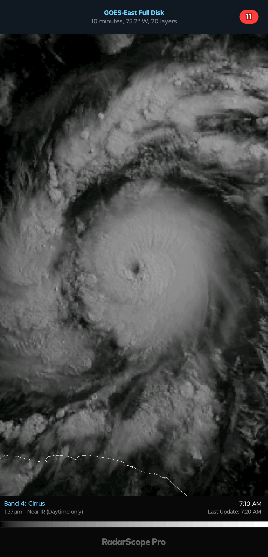
 PACK IT UP LADS IT’S OVER FOR THR CARIBBEAN Hurricane Beryl Satellite | Buoys | Grids | Storm Archive ...BERYL IS NOW A VERY DANGEROUS CATEGORY 3 HURRICANE... ...LIFE-THREATENING WINDS AND STORM SURGE EXPECTED IN THE WINDWARD ISLANDS BEGINNING EARLY MONDAY... 8:00 AM AST Sun Jun 30 Location: 10.6°N 53.9°W Moving: W at 21 mph Min pressure: 968 mb Max sustained: 100 mph
 -
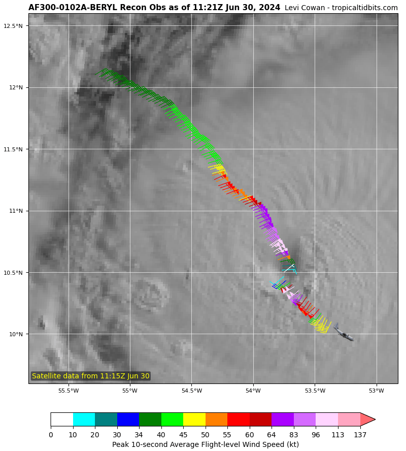
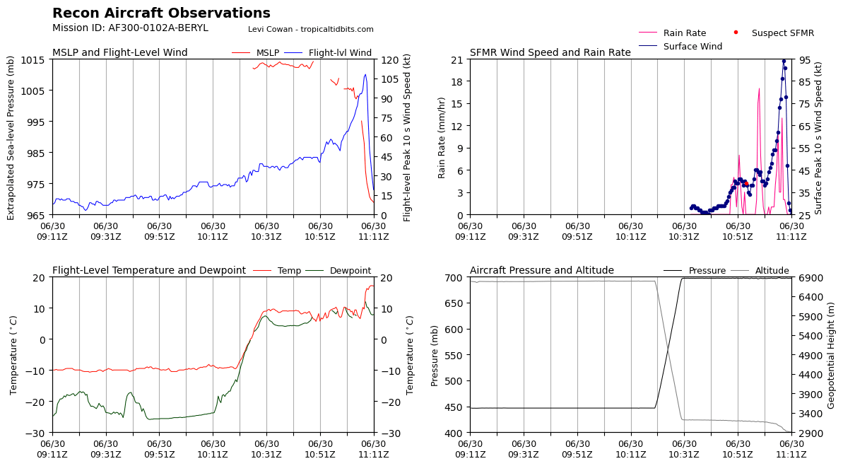
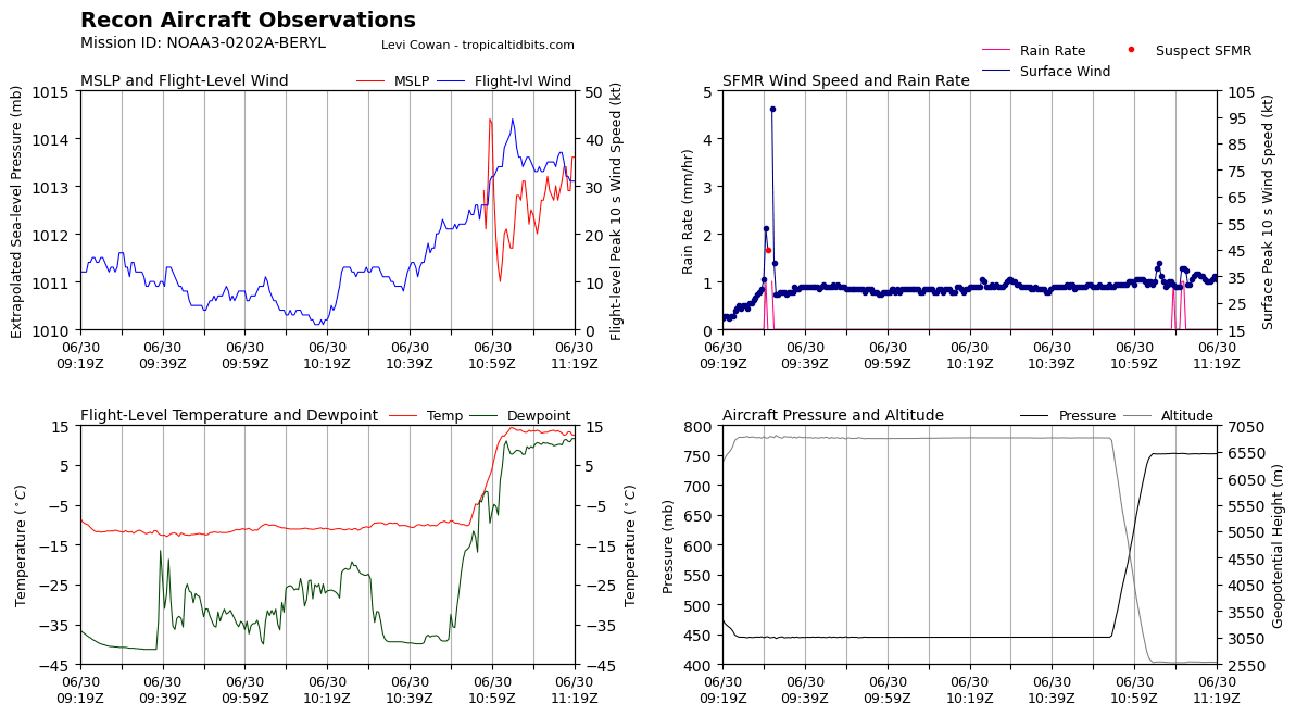
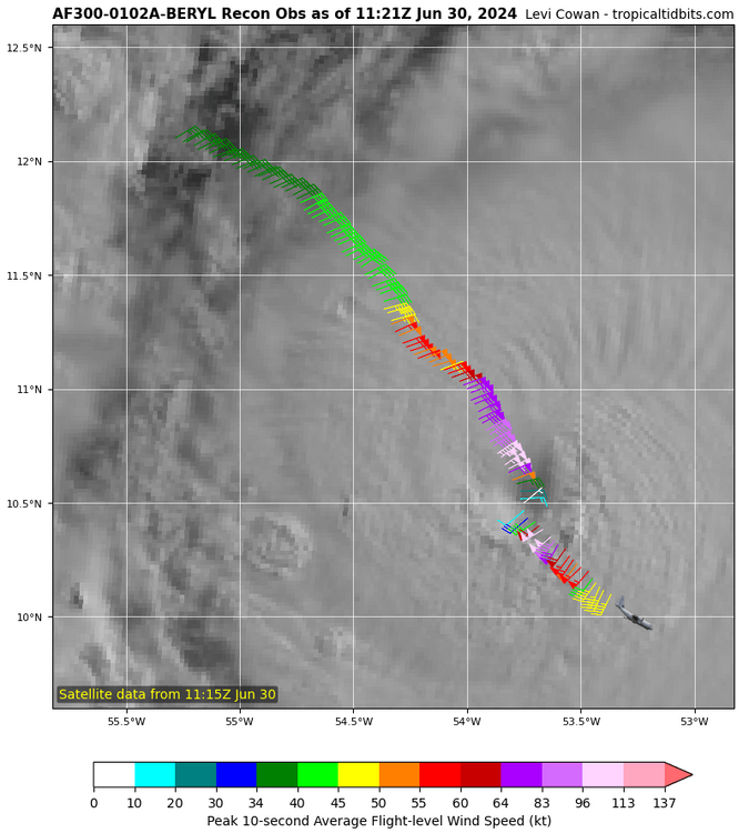
Peak Flight-Level Winds: 108kt at 11:08zPeak SFMR: 94kt at 11:08z Minimum Extrap. Pressure: 968.7mb at 11:12z
-
It’s over pack it up boys
-
Didn’t reach the eyewall jfl 108 KT FL 94KT SFMR


-
Hopefully she does not.
-
Gyatt what a mogger. primed for RI
-
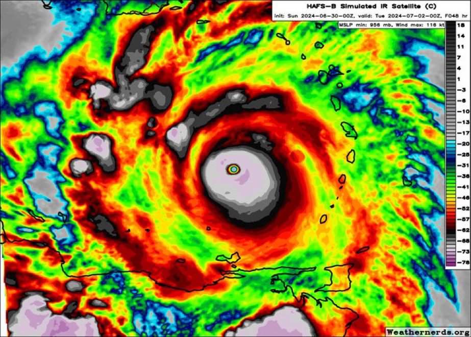
Gyatt this is brootal from HAFS B
-
thank YOU bhai do you think I am a permarotter jfl YES! Also mirin the term Barrettese joever/jova means “over” What do you think is the maximum possible peak for Beryl?
-
EXACTLY. And gandy forbid what’s going to come in July, August and September
-
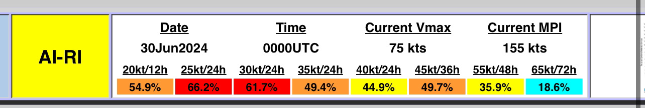
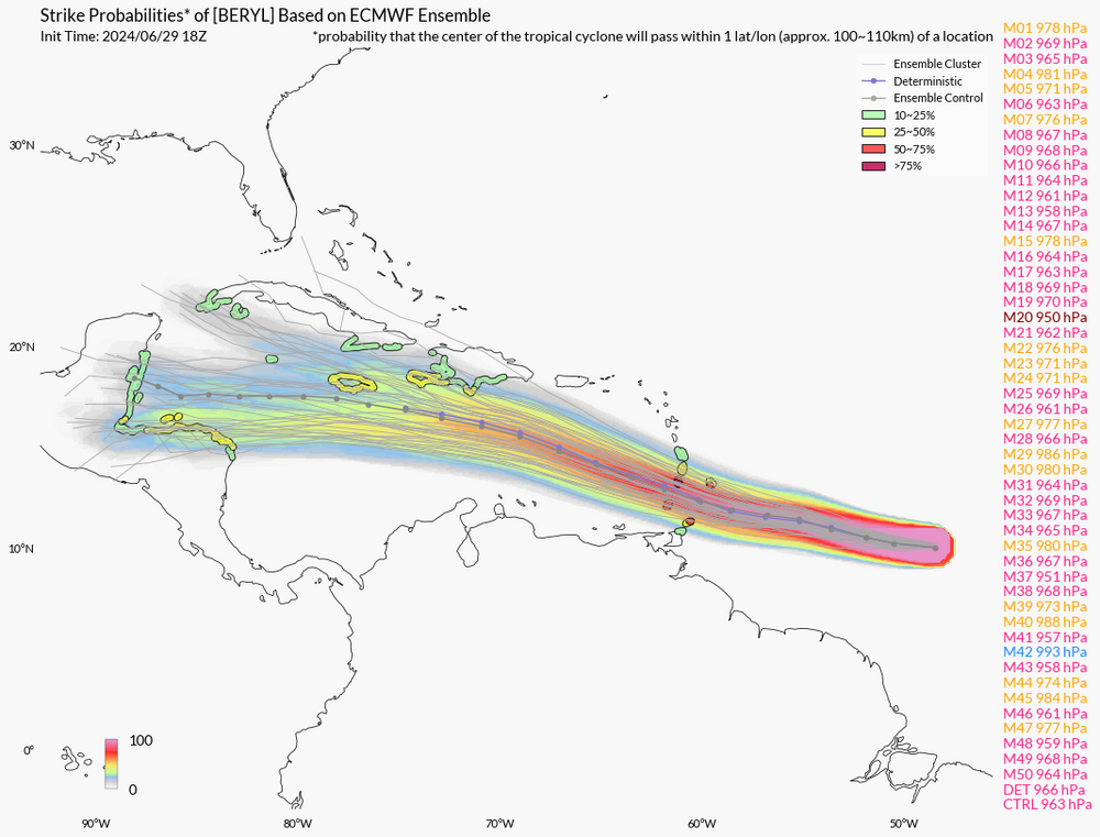
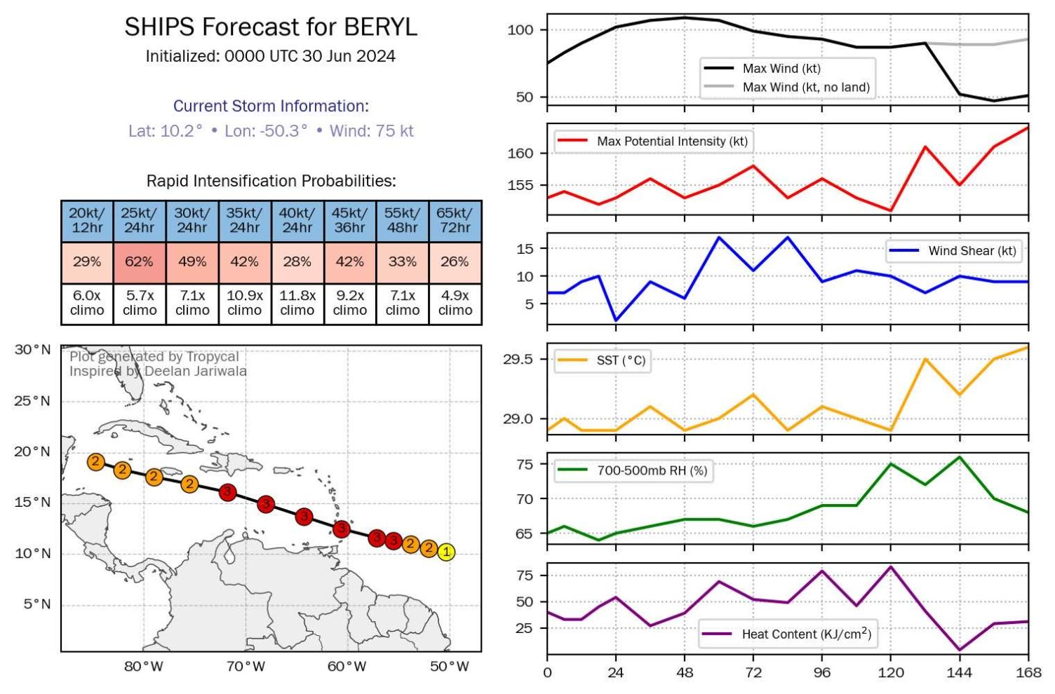
sheeit this sounds ROUGH ngl Unfortunately Beryl has all the ingredients favorable for continued rapid intensification in the short-term. The light to moderate easterly shear that had been affecting the system is subsiding, while the hurricane remains embedded in a large area of deep-layer moisture and over 28-29 C sea-surface temperatures. The small and well-organized inner core likely means the hurricane should take full advantage of these pristine conditions, and both the GFS and ECMWF versions of SHIPS-RII show rapid intensification indices 7 to 10 times above climatology. Thus, the latest NHC intensity forecast will explicitly show rapid intensification over the next day, making Beryl a very dangerous Category 3 hurricane before it moves across the Windward islands by tomorrow night. Once Beryl enters the Caribbean, there could be a marked increase in westerly vertical wind shear as a strong easterly low-level jet, common for this time of year in the eastern Caribbean Sea, will keep Beryl moving quickly westward against lighter upper-level upper-level easterlies partially eroded by a deep-layer trough off the Eastern Seaboard. Thus some weakening is forecast after 48 hours as Beryl moves further into the Caribbean. The NHC intensity forecast remains close to the reliable consensus aids and now shows a peak intensity of 110 kt in 36 hours, though a few of the regional-hurricane models do peak Beryl stronger than shown here.
-
IT'S OVER
-
2024 Atlantic Hurricane Season
CurlyHeadBarrett replied to Stormchaserchuck1's topic in Tropical Headquarters
94l might actually luck out jfl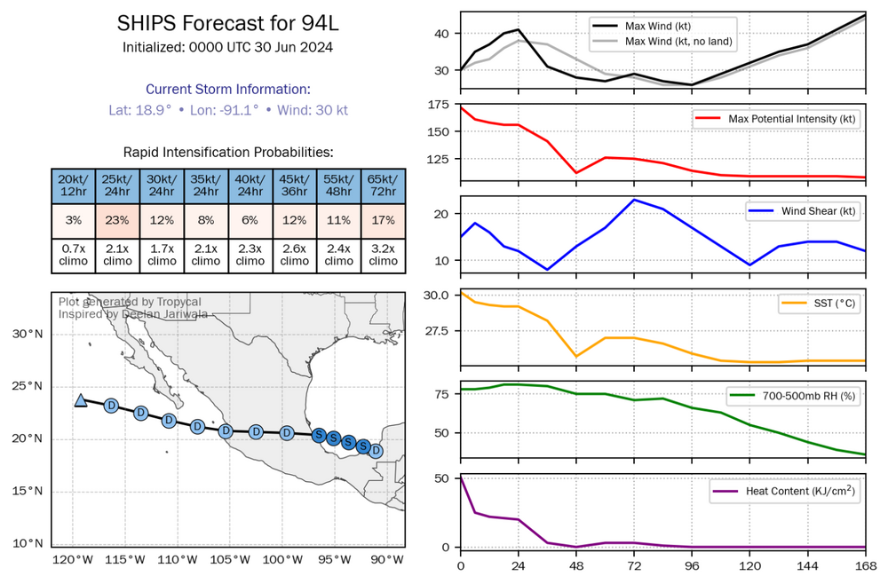
-
..BERYL STILL RAPIDLY INTENSIFYING... ...EXPECTED TO BRING LIFE-THREATENING WINDS AND STORM SURGE TO THE WINDWARD ISLANDS AS A MAJOR HURRICANE... FORECAST POSITIONS AND MAX WINDS INIT 30/0300Z 10.4N 51.2W 75 KT 85 MPH 12H 30/1200Z 10.8N 53.7W 90 KT 105 MPH 24H 01/0000Z 11.5N 57.0W 105 KT 120 MPH 36H 01/1200Z 12.3N 60.4W 110 KT 125 MPH 48H 02/0000Z 13.4N 64.0W 110 KT 125 MPH 60H 02/1200Z 14.6N 67.6W 105 KT 120 MPH 72H 03/0000Z 15.6N 71.7W 100 KT 115 MPH 96H 04/0000Z 17.0N 78.9W 85 KT 100 MPH 120H 05/0000Z 18.5N 85.0W 75 KT 85 MPH $$ Forecaster Papin

-
I have been online since the AOL days
-
20% CHANCE TO TURN INTO A CATEGORY 5. IT'S SO JOVA FOR SAINTVINCENTCELS AND BARBADOSCELS

-
Great red spot mogs Mahghkut to death
-
Thank you bhai. What's the max Dvorak you think Beryl would peak at?
-
1995 is a cusper?
-
Correct. Also not a molecule means nada in this case