
JenkinsJinkies
-
Posts
170 -
Joined
-
Last visited
Content Type
Profiles
Blogs
Forums
American Weather
Media Demo
Store
Gallery
Posts posted by JenkinsJinkies
-
-
Let's see ~4 inch YTD surplus in Baltimore
2.83 inch YTD surplus in DC
Yeah the bump was premature.
Also compare to last year:
Most water tables were at August levels and it was the driest YTD ever, a record that stood well into June.
-
14 hours ago, stormtracker said:
Get your quarter ready.
It'll be late March, I'm thinking dime.
-
 1
1
-
-
3 minutes ago, WinterWxLuvr said:
I’m ready … show me the snow maps for our coming snow


-
 3
3
-
 2
2
-
-
9 hours ago, Jebman said:
Snow in March! Snow in March! Snow in March!
Too bad it’s 14 days away, watch the pattern collapse 5 days from now.
-
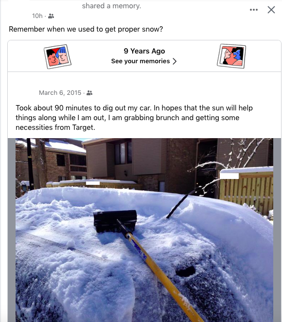
A post from a facebook friend, screenshot redacted for privacy reasons.
-
2
-
-
Every time the west coast gets atmospheric rivers in the winter it’s mild and snowless here. As soon as the winter week was over in January California got a conga line of atmospheric river storms.
Same thing happened last year too, and in 2016-2017. Whatever mechanism causes this is probably one of the things stacked against us.
-
1
-
-
4 hours ago, Cobalt said:
Crazy how the late February HECS loading pattern very quickly became the 2025-2026 winter loading pattern instead
Niñas almost always double dip. So it’ll be 2026-2027
-
9 minutes ago, psuhoffman said:
For the last 5 years many who tried to deny how bad it’s getting have said the same thing “wait for a Nino”. That was their hold lot hope.
I can see them moving over to the PDO since that's the one variable that hasn't changed yet.
-
2 hours ago, Terpeast said:
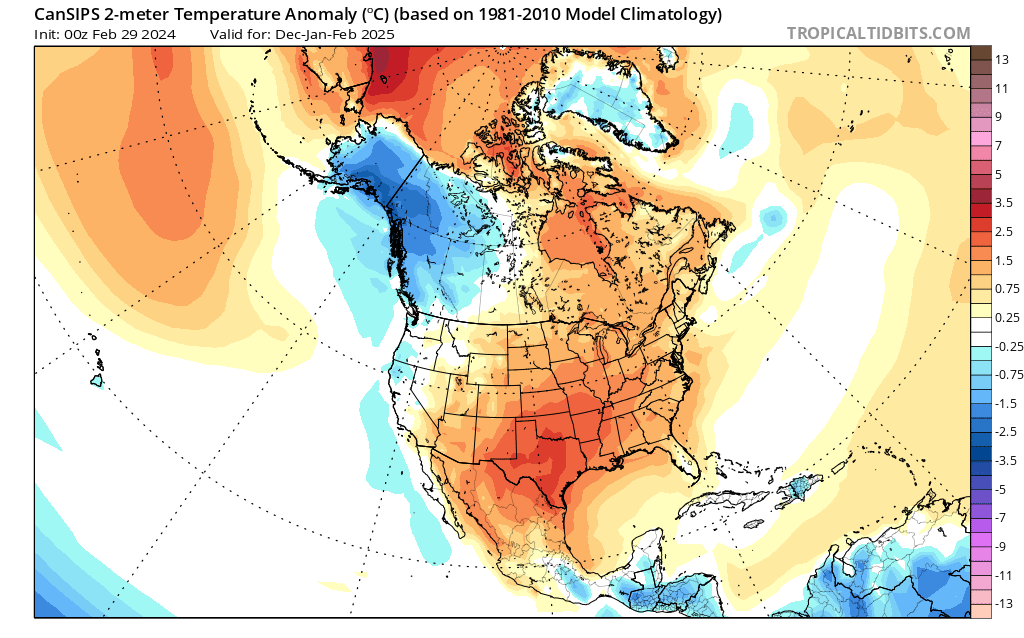
A look ahead to the 2024-25 winter... not for our own backyards, but WHERE to travel and chase (and when):
New CanSIPs just came out, and it performed well on a smoothed/seasonal basis for this winter. It showed a wet first half, then a slightly drier second half, and a mostly warm CONUS with near normal/slightly BN southeast.
So here's what it is showing for next winter now...
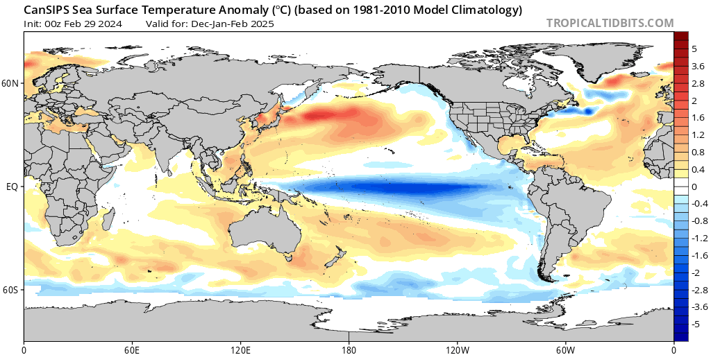
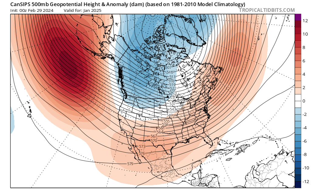
1) Moderate-strong La Nina, basinwide or even a little bit modoki. MJO should be active in the eastern IO through the MC (phases 3, 4, and 5). Negative PDO signature appears obvious, with that marine heatwave off Japan still ongoing and no signs of ceasing.

2) Standard La Nina h5 configuration enhanced by overall warming with a solid +AO/+NAO (or lack of blocking overall). Take away that -NAO block in December 2022 in the 2022-23 winter, then you'll get a good idea of what this winter is going to be like.
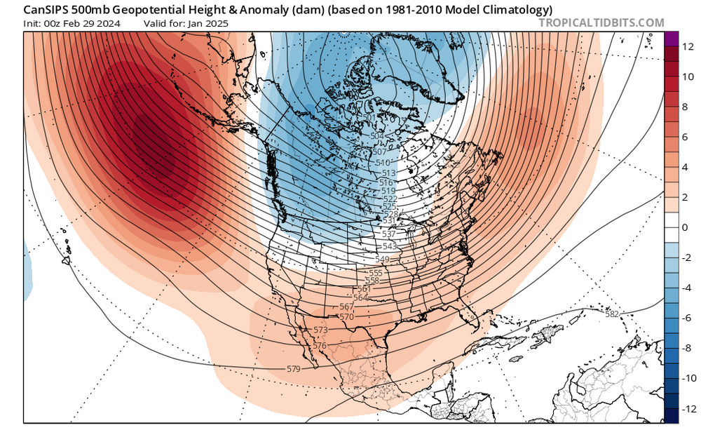
3) Again, a mostly warm CONUS just like this year, except the warmest anomalies are displaced south across New Mexico, Texas, and through the Tennessee Valley. (I wonder what raindancewx has to say about his backyard having the warmest anomalies).
However, the west coast and Pacific Northwest are depicted to have near to slightly below normal temperatures.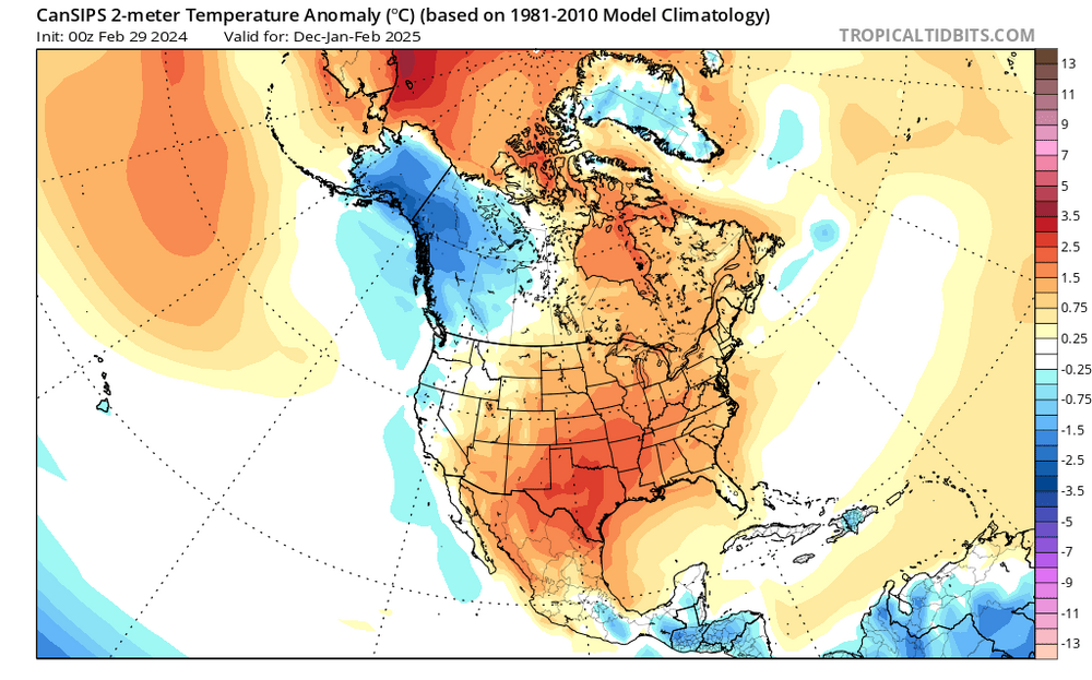
4) Opposite to this winter, the south and southeast are depicted to be drier than normal. It would not surprise me if we got a hot and dry summer, with drought conditions redeveloping across the east.
Wettest anomalies are shown over the Pacific Northwest, and with normal to slightly below normal temps, the mountains in that area could be the best places to chase.My brother lives in Spokane, and they may be set for a great/historic winter next year. Seriously considering an extended two-week visit there, renting a car, staying with him for 4-5 days, then drive to Montana's rockies for a few days, then back. Or if the Cascades are about to get a big one, we could chase there instead.
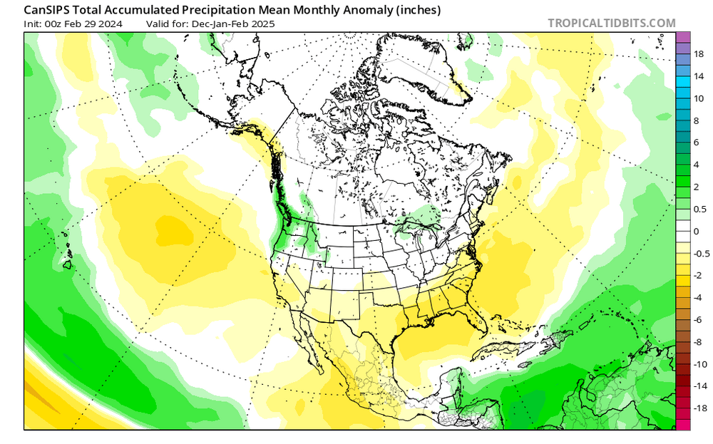
Again, this is to show you where to plan your chases for next winter, not for snow in your backyards.
Still though, the weenies here will be insufferable next winter.
-
Enjoy the sub freezing nights because that's probably the only lion we're getting from this March.
-
1
-
-
March 10 was hyped up last year too and look how that one turned out…
-
 1
1
-
-
1 minute ago, LibertyBell said:
and there's not even any trees out there...
Wildfires can still happen in grasslands
-
1
-
-
There’s a wildfire in Texas right now, 2nd largest in US history. It’s still meteorological winter…
-
1
-
-
Looks like DC will stop short of 70s from this torch.

-
2 hours ago, stormtracker said:
So now I gotta watch out for blue robes and hoods now.
Whatever you do don’t play earthbound.
-
9 hours ago, Maestrobjwa said:
I think you just coined that term, hahaha Well done
No, it’s from king of the hill.
-
1
-
-
This thread will be researched as a case study of when hopes get raised and dashed in a very short period of time.
We all got hopelash.
-
1
-
-
20 minutes ago, CAPE said:
One thing is for sure, the anomalously warm water in the Sea of Japan with Siberian air flowing across it is perpetually dumping snow in NW Japan. Not unusual ofc. These city folks probably can't wait for Spring, but I do love how they just keep going, business as usual. NBD. No effing road salt.
Because Hokkaido has the climate of Canada.
-
3 hours ago, psuhoffman said:
It’s not that I’m not nervous about this. I’ve seen some things that bother me. There were times people were using the pacific as a blanket scapegoat and I pointed out at times we had the exact opposite long wave configuration yet the SER remained! But our last +pdo it snowed plenty. On the whole 2014-2018 was extremely snowy. So we have no evidence yet that a pos pdo has been affected by this recent tendency.
In the future when the pdo flips heading into winter this place will be swamped.
-
1 hour ago, Terpeast said:
Well, going by this chart, it's been mostly negative since 1998 with brief pos interruptions. Either the cycles are shortening, or we're going to flip to positive within 2-5 years.
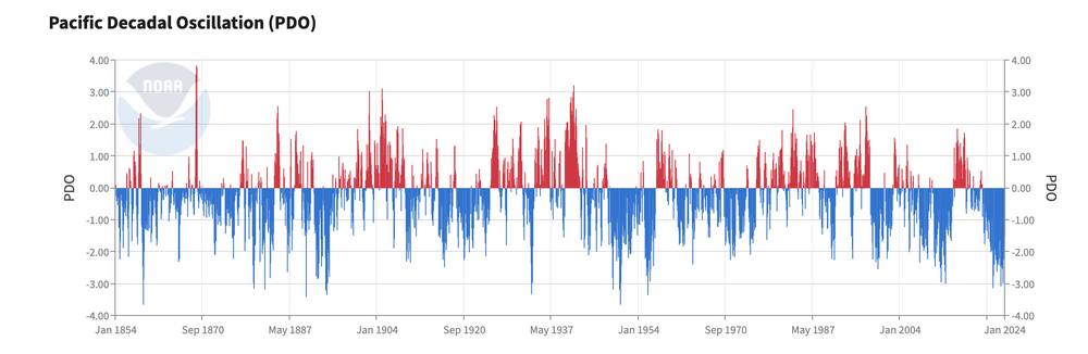
If you look at that chart it was + for a bit in the mid 2010s.
-
6 minutes ago, EastCoast NPZ said:
I think I said it back in 2016 coming off 3 consecutive AN winters..... 3 out 4 winters here are probably BN, so we were staring at 9 ratters coming down the pipe. Looks like we're getting them all in succession. '25 - 26 is our year.
25-26 will most likely be the 2nd year of a double dip nina. Massive bust based on the last few years.
-
On 2/20/2024 at 9:30 PM, DarkSharkWX said:
the record -PDO not even coming close to flipping is nonetheless surprising
I mean the D in that stands for decadal and it’s only been in place for a few years.
-
With the incoming pac puke w could get a t-storm at the very end of the month like in 2017.
-
There’s already articles about the niña supercharging hurricane season.
https://www.yahoo.com/news/already-hurricane-season-waters-atlantic-150024951.html


2024 summer maximum temperature forecast contest (DCA,IAD,BWI,RIC) _ enter by 06z June 15
in Mid Atlantic
Posted
DCA - 98
BWI - 99
IAD - 99
RIC - 100