

Stormchaserchuck1
-
Posts
2,091 -
Joined
-
Last visited
Content Type
Profiles
Blogs
Forums
American Weather
Media Demo
Store
Gallery
Posts posted by Stormchaserchuck1
-
-
La Nina is not a function of climate change, and that is what the problem recently has been.
-
4 hours ago, mattie g said:
I’m still so confused about what happened to our mega look we were supposed to be coming into.
Models adjusted more than usual. They had a ridiculous strong 50/50 low signal at 10-13 day lead, that is now a High pressure anomaly on models for the same time. There was also a big N. Pacific Low that was suppose to develop and sustain, and it's pretty weak now. I've seen what happens a lot, is when the upper latitudes don't match what the models show in the CONUS (they never really showed big cold/trough over the EC), something, somewhere will adjust (lately it's been adjusting warm).
Euro weeklies have been very little better than trash. I continue to stand by that.. they got January wrong by 4-5 degrees, and now the same thing is happening in late February and March. The LR images brooklynwx kept posting, through March 20th, are going to come to nowhere close to verifying, especially over the Pacific Ocean! NG futures (where the money is) was 5x more accurate all Winter long.
-
I ended up with less than 1". Really bad call saying that WSW's would go up, up here based on the RAP and Hrr consistently giving 4-6". It wasn't really cold enough in the end, and the precip under achieved a little (here).
-
Signs that it could get very warm in the last few days of the month.. maybe 60s
-
22 minutes ago, Ravens94 said:
Lmao dry slot wasn't picked up till 2 hours ago total killer
GFS and NAM had it in their snow depth charts.
-
Snow picking up here.
-
 1
1
-
-
Cooled down nicely here in the last few minutes.. snow starting to land. 31F
-
1
-
-
eh.. we'll see how the backend does, but this seems like a bust.
-
I don't like that the dryslot is north of Rockville!
-
Just now, Ravens94 said:
Changeover imminent
Yeah, started changing over just when I posted that.
-
That is a nasty dryslot working into DC.
Still all rain in Fallston. Temperature says 33 degrees. Edit: just started to mix in with snow.
-
56 minutes ago, psuhoffman said:
You can’t ignore the western N American part of the PNA equation though.

Yeah but the Pacific dominates
Only a 0.3 correlation in the South-SE, and it's technically all 3 areas. I'd rather just go to the source..
-
1
-
-
Yeah, 00z and 01z has trended a little weaker at 500mb.
-
eh.. it's warmer at 11hrs.
-
0z NAM does have the low a little north of 18z at 5hrs.
-
10 minutes ago, snowmagnet said:
But is it right? Isn't the EPS colder?
ENSO subsurface is showing a -3c pocket now in the central region at -200m. In my research/experience, that has a pretty high correlation to the N. Pacific pattern at 0-time (backs the -PNA idea). Plus we are in some strong multi-year states with that 500mb feature in Feb/March.
-
3 minutes ago, psuhoffman said:
Except that’s the polar opposite ridge trough configuration as the plot I posted that you also called a -pna. You can’t just call every bad pattern here -pna. It might not have been good for us but that full latitude ridge in the west I posted is most definitely a +pna. The region you were focusing on is more the epo domain. There is some overlap and ideally we want a -epo +pna.
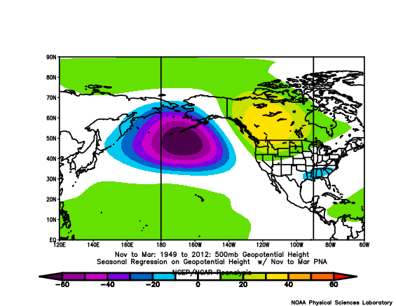
The main region for PNA is in the N. Pacific Ocean south of the Aleutian islands.. Both, or all 3 images shown so far had a ridge there (-PNA). I don't call what's happening over alaska or gulf of alaska, pna, although the CPC does include that.
-
Here's 18z GEFS.. just a crazy ridge south of the Aleutian Islands
https://ibb.co/9WycxzfHere's something I posted a few ago, https://ibb.co/ZgvkXCY
With a Strong El Nino at the surface, and negative in the subsurface, and now +250dm -PNA appearing, it hits this +correlation, which I have found is better than surface conditions.
That's a really warm pattern setting up there on the LR GEFS with the EPO going + too..
-
2
-
-
4 hours ago, Terpeast said:
Yep. He was saying that nat gas futures were indicating a warm winter ahead. I thought that was odd, yet here we are.
Sometimes when the mathematical variability is so strong, it's worth considering. Ideally, weather forecasting should outperform Energy Futures because you would think we have better methods.. they are speculating. but that's not been the case for a while. I'm really surprised that the global models just had El Nino-climo, when we have had such a strong -PNA for the last 6 years, and the El Nino was not correlating with it April-Oct. With that strong 24th -PNA I just showed in the previous post, it looks like we may come in near neutral in the PNA region for February, which is in line with this record streak that we are in.. But the global models had like a -120dm to -150dm +PNA for the month.. just normal ENSO climo.
-
1
-
-
4 minutes ago, Maestrobjwa said:
Chuck...real question: Why do you use these maps instead of going on TT, WB, or something more uh...modern?
It's easier to use, save, animate, quick loading time, doesn't go down being a NOAA site. I don't think there is a very big difference between the quality of all the different maps. If something is better, I would use it.
-
2
-
 2
2
-
-
16 minutes ago, psuhoffman said:
look +pna. Happy?
I'd say it's more -PNA/-PDO with a ridge south of the Aleutian islands and trough over Alaska.
12z GEFS was really strong -PNA around the 24th, with this central N. Pacific High pressure. We don't trend toward snow when this.
-
23z Hrr looks a little bit better.
-
1
-
-
2 minutes ago, NorthArlington101 said:
18z EURO pretty stellar for our northerner friends. Send pics tomorrow!
Will do.
23z RAP still showing 6" up here.
-
2
-
-
1 minute ago, clskinsfan said:
Where is the cold air coming from?
Low pressure is a little N in Tenn from where models had it.
Mid/Late February will be rocking. (This year we mean it!) February long range discussion.
in Mid Atlantic
Posted
With a +QBO 90% likely, no less. That with Stronger La Nina favors +AO conditions, and I'm just saying the last time we had that happen it hit 80 degrees in January.. that's kind of a baseline, although of course it could get cooler/colder at times.