

RU848789
-
Posts
3,617 -
Joined
-
Last visited
Content Type
Profiles
Blogs
Forums
American Weather
Media Demo
Store
Gallery
Posts posted by RU848789
-
-
Giant parachutes!! Gotta go outside...
-
 1
1
-
-
Latest HRRR (if it's right) has me getting 3" snow by 11 pm or about 1" per hour. Not so sure sleet doesn't mix in earlier, though, looking at the radar map at 10 pm. My sounding is definitely snow through 9 pm, but 10 pm looks iffy. Any experts care to comment? I'm hoping it's just wet snow...

-
1
-
-
3 minutes ago, Allsnow said:
All snow now
29
Nearly 100% moderate snow now! Saturation, lift and rates FTW!
-
2
-
-
It really did come in like a wall - would've been cooler to see a wall of snow, but this is still pretty good. Every surface covered already and we have some flakes mixing in.
-
1
-
-
Surprisingly, sleet just started here around 7:25 pm at 32F (wet bulb temp ~26F) and we have a little dusting already - thought it would start later here, but a slug of precip on the radar hit here early.
-
Surprisingly, sleet just started here around 7:25 pm at 32F (wet bulb temp ~26F) and we have a little dusting already - thought it would start later here, but a slug of precip on the radar hit here early.
-
1
-
-
1 hour ago, Allsnow said:
The trend today has been weaker with Tuesdays energy and putting all the energy into Thursday. It’s over for Tuesday outside central Va
It's not over until we say it is! Was it over when the Germans bombed Pearl Harbor?!
-
 1
1
-
-
37 minutes ago, Tatamy said:
Not sure where you got that radar view on the bottom from but it’s not correct.
Thanks, shouldn't have trusted the weathertap radar, lol. Dual pol shows the sleet signature pretty well in PA; as I just said in another post, my comparison was more about the precip intensity being much closer to the HRRR than the NAM, which is still a good thing at least for now.
-
18 minutes ago, jm1220 said:
CC radar has sleet almost to Williamsport. HRRR is too cold.
Yep, just looked at that and can see the sleet signature. Also, the main part of my comparison was the radar intensity/precip looking much more robust and close to the HRRR as opposed to the NAM. There have been two "trends" that concern most - less precip on the NAM and some other models, especially W and SW of NYC and faster WAA driven transition to sleet like the NAM vs. what some of the models show. Personally, I'd rather get the higher QPF and mostly sleet than low QPF and sleet (if I can't have snow).
-
1
-
-
29 minutes ago, Allsnow said:
I think this looks pretty identical to the radar currently in Pa. Everything looks aimed towards the metro but what ptype is up to debate. I do like how strong and solid the returns looks currently

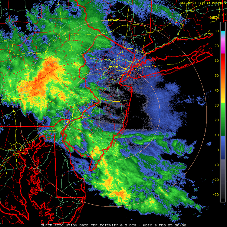
Agreed. The current radar at 6:30 pm is quite close to what the fairly snowy 21Z HRRR was showing for 7 pm pm, whereas the 18Z NAM at 7 pm looked weak and spotty. Doesn't mean the HRRR will be right and the NAM wrong, but that's the case so far, IMO.


-
Just now, Bxstormwatcher360 said:
Keep the faith bud,i know i do even when it looks bleak. Lol
Don't get me wrong, I'm very concerned about getting mostly sleet as I'd like to see some snow and the trends have not been good for mostly snow for anyone really, but the NWS knows more about this stuff than I do and I just hope they're going to be right. I'd rejoice if I got the forecast they have for me of 3.4" of pretty dense snow and sleet that comes from 0.59" of QPF, with 0.06" of ZR on top of that.
-
2
-
-
Also, the NWS-Philly hasn't thrown in the towel by any stretch as per their latest AFD, below. My forecast has actually had snowfall go up to 3.4" (I'm in the 3-4" swath in far northern Middlesex County. If the drier and warmer aloft-faster trends on several models verify, could be one of those storms where there's a significant difference between, say NB and places like Freehold, Trenton or Frenchtown to the S/SW/W, i.e., decently more snow and precip in NB. Maybe. Time to watch the radars and it's certainly plenty cold for snow/sleet with temps around 32F, but low humidity and dewpoints in the upper teens meaning the wet bulb effect will get most down into the mid/upper 20s for awhile. Going to be an interesting next 8 hours or so.
Further north, a burst of moderate to heavy snow looks likely after sunset for the Lehigh Valley, Poconos and northern NJ, possibly extending into the northern Philly suburbs and central NJ briefly, before the change to sleet and freezing rain. Where that lingers longest as snow, highest accumulations will be found, with 3-6 inches expected in northernmost NJ, 2-4 inches in the Poconos and the rest of north-central NJ, and 1-2 inches in the Lehigh Valley, northern Philly suburbs and central NJ. This prolonged period of snow, followed by sleet, should result in less ice accumulation, closer to a tenth of an inch or less.-
1
-
-
FWIW, the HRRR does jump around and has gotten a fair amount snowier, especially on the S and W margins in CNJ, over the last 4 runs. There's still hope, lol...

-
3
-
-
1 minute ago, NEG NAO said:
we will see I will be visiting friends in Metuchen on Monday.....I say it all depends how much sun shines........
That matters a bit too, of course, but it's not April yet, so I think more than half will still be around and 90% in the shade - and I happen to live on a shady property (across from Tommy's Pond if you know Metuchen).
-
1 hour ago, Tatamy said:
I am bare here. I am figuring maybe a half inch of sleet with some ice to boot here.
Why so low? NWS has you getting ~2" of dense snow/sleet (0.4" QPF as snow/sleet, so ~4" of snow worth), then 0.1" of ZR which will be absorbed into the pack. Do you think they're going to be that far off?
-
3 hours ago, NEG NAO said:
you think there will be anything left on the ground before the next possible event mid-week ?
100% yes, assuming we get ~0.5" frozen QPF (and especially if it's mostly sleet, which melts more slowly than snow), given highs in the upper 30s Sunday and Monday and cold nights
-
Keep forgetting to post this for giggles...
Last, but not least, my guess for my house in Metuchen is 1.5" of snow, then 1" of sleet (~3" of snow equivalent in that sleet) for 2.5" snow/sleet on the ground, then 0.1" of freezing rain on top. We'll see...
-
1
-
-
24 minutes ago, SnowGoose69 said:
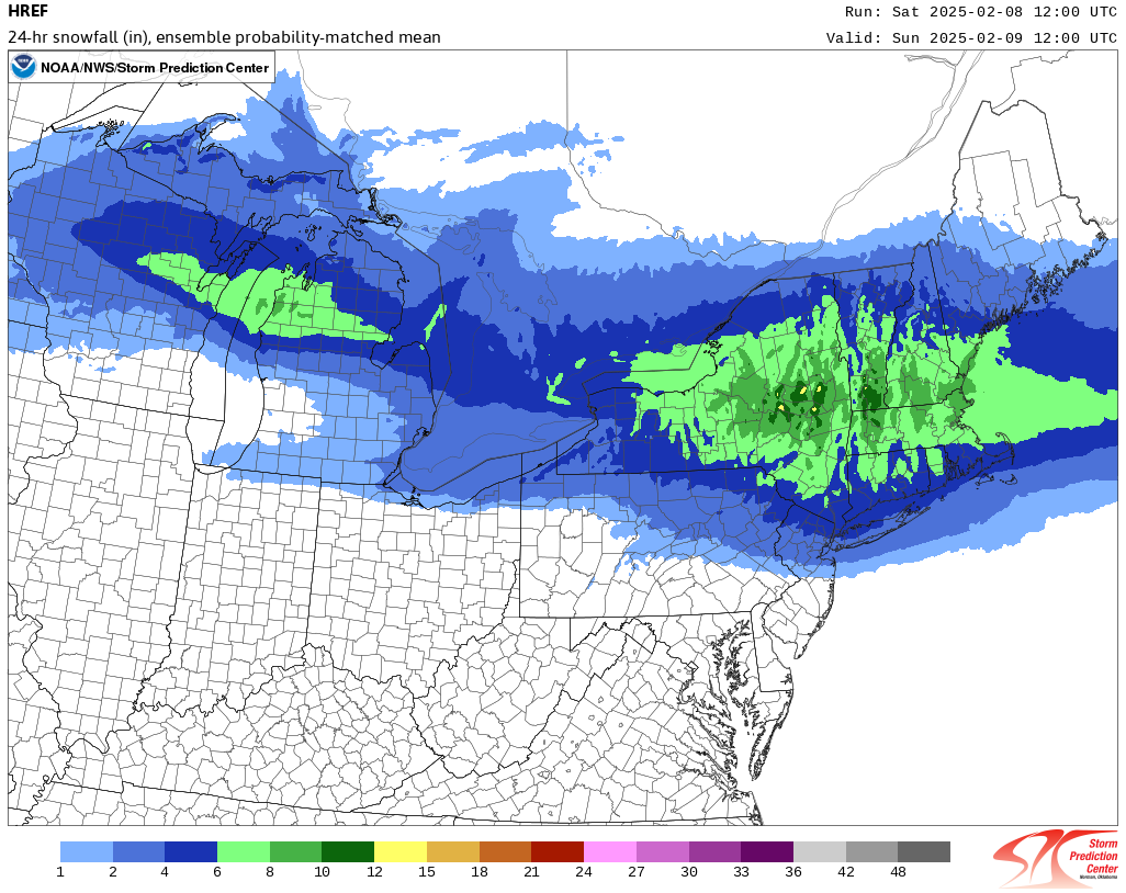
In an event like this with massive mid level WAA I never really look at thickness. I typically only do it for all snow type events where its marginal temps and then I use 1000-850 which until recent years practically no online websites even had anyway, you basically needed to be an NWS employee and have AWIPS til about 10-15 years ago to view it. It usually works way better in a marginal temp event than 1000-500. I think in the January 2008 storm the 1000-850 argued the area would see no snow at all. I recall a MET posting that on the old forum
Thanks, this is great insight. Is this 1000-850 readily available? And what's it telling you for, say, my house in Metuchen - or at least in general for the 95 corridor/NYC?
-
24 minutes ago, donsutherland1 said:
No. It assigns precipitation type based on the top of the hour, so some mixed precipitation can be included, which can overstate snowfall estimates. Usually, I assume one category lower when there is mixed precipitation events such as what is likely this time around.
The site is freely available at: https://www.spc.noaa.gov/exper/href/
Awesome, thanks!
-
7 minutes ago, SnowGoose69 said:
This is gonna be the worst sleet event for the metro since maybe 2/2007
Question if you don't mind: how much do you use the 1000-500 mbar thickness 540 line "rule of thumb" for divining the snow/rain (or mix) line? I think every model has the 540 line along/N of 84 when it's precipitating, even the snowy HRRR.
-
Prety sure nobody in Philly wants the 12Z NAM to be right - almost all ZR...

-
1
-
-
Just now, ILoveWinter said:
Yes tho the NAM showed basically nil for CPK, this is at least 3 which is within Uptons range.
People need to stop with the "nil" comments from the NAM - it showed 5-6" of snow as sleet, i.e., about 2" of sleet. That's pretty damn impactful if not pretty.
-
46 minutes ago, donsutherland1 said:
The 12z HREF is little changed from 0z.

Don - I assume the HREF is showing just pure snow correct (like Pivotal does)? Also, is this available free somewhere? TIA.
-
1
-
-
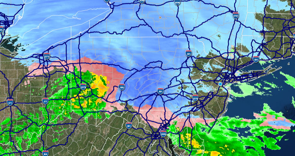
Found this to be interesting...hadn't noticed the snow depth before - assuming that is sleet where no "snowfall" is shown on the regular map, since Pivotal doesn't show sleet, per se.


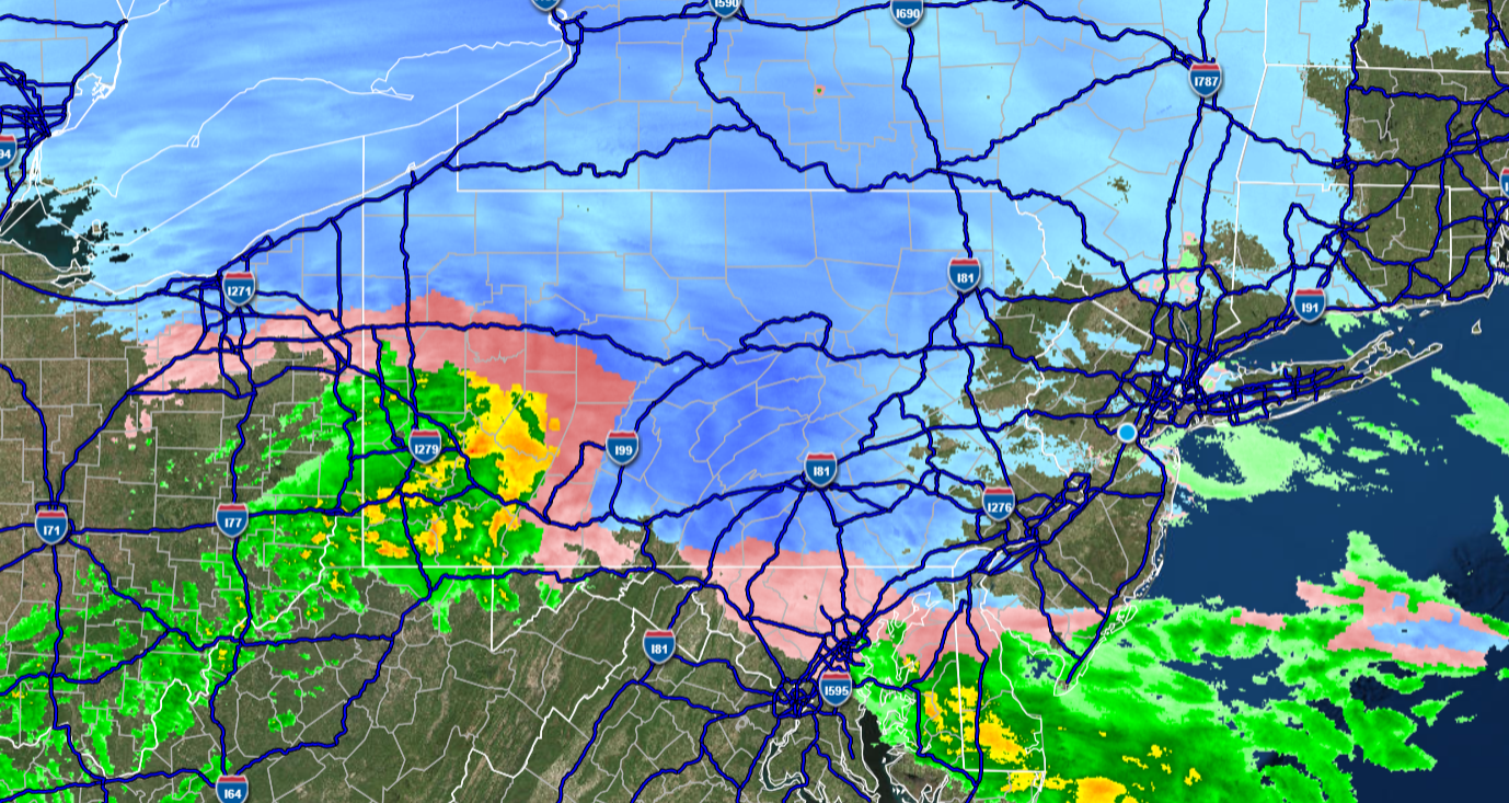
Discussion-OBS Weekend Feb 8-9 Another mainly 12 hour snow-ice event possibly changing to rain before ending Sunday. NYC-LI-S of I78 on the edge?
in New York City Metro
Posted
Was very cool, but then it turned back to a 50/50 mix - wonder if I'll be seeing a lot of that back and forth...