

RU848789
-
Posts
3,617 -
Joined
-
Last visited
Content Type
Profiles
Blogs
Forums
American Weather
Media Demo
Store
Gallery
Posts posted by RU848789
-
-
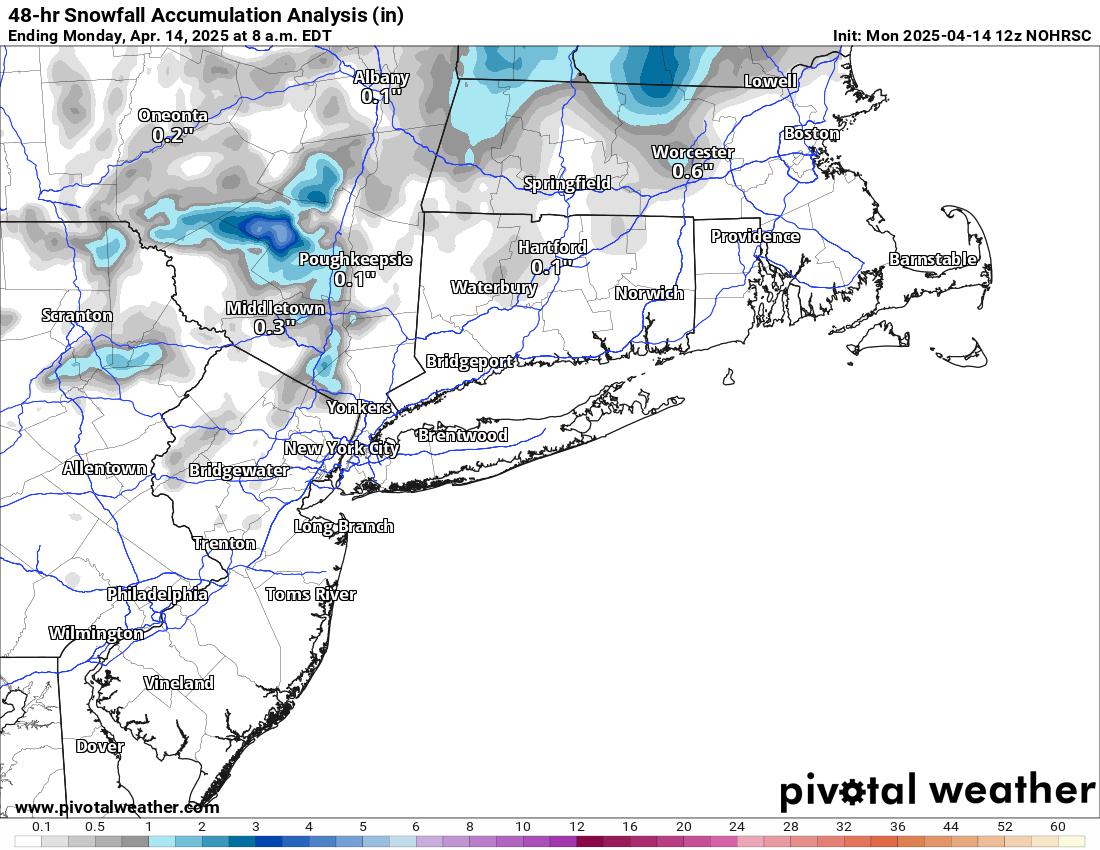
Do people think this looks right? Seems overdone for me, especially at lower elevations...
-
 1
1
-
-
1 hour ago, Feen said:
does anyone have the euro AI snow map?
It has some snow for areas mostly N of 80 on 4/8 in the map below; it also has some more snow on 4/12 for areas N of 84 and then even more on 4/18 for the Catskills/Berkshires and north. Assuming you want the first one that gives you a bit of snow.

-
 1
1
-
 1
1
-
 1
1
-
-
22 minutes ago, donsutherland1 said:
AI has an enormous amount of learning to do with snowfall forecasts (the GFS's problem is structural) and such forecasts will grow more skillful with the additional learning. I could see Boston having a small amount of measurable snowfall (probably < 1" monthly total), but don't see the kind of pattern that brings anything close to what that map is showing.
Historically, there are no snowstorms on record that saw 6" or more in Boston and 4" or more in both New York City and Philadelphia on or after April 10th. The latest such storm (and only on after the first week of April) occurred during April 8-9, 1917. Prior to regular recordkeeping, a storm that met and exceeded such criteria occurred on April 12-13, 1841.
Agree on all counts, hence my "lol." The only thing that gives at least a little credence that we could have a bit of snow in some places around then is the CPC's forecast for that period to be well below normal in temp.

-
 1
1
-
-
Only 11 days out and it's not the GFS, lol...

-
 1
1
-
-
Another virtual monster snowstorm on the 6Z GFS on 4/3. That's about 48" from the GFS over the last 2-3 weeks, lol. At least for this one the AIFS is showing 1-2" NW of 95, which could be plausible.
-
How fitting this would be for most of NYC Metro, lol...

-
 5
5
-
-
5 hours ago, Brian5671 said:
18Z or 0z it will shift north to match the others-there was another recent event where it did this....a clipper around 3/1 which was way too far south
Not only did that not happen, but the Euro is now showing an inch or two along/N of 80 at 18Z, instead of well N of 84 at 12Z. It's not being a weenie to simply point out what models are showing. There are still no other models on board and 95 snow is still a very low probability, but not zero - and both the NWS Philly and NYC offices are now mentioning the potential for at least inland snow for the first time.
-
Not sure I can recall a single model being such an outlier for so long and this close to the event (72 hrs). It almost has to be wrong, but...

-
1
-
3
-
3
-
-
50 minutes ago, Wannabehippie said:
I wouldn't hold my breath on this if I were you.
What makes you think I am? I think I've made it clear that this is a very low probability event for 95, at least, but it's not a zero probability event, as snow is obviously possible in late March. Would need to see support from other models to start to be truly interested in this.
-
Some much needed rains...

-
1
-
-
12Z GFS still shows snow for Friday, which is not that far off. Of course, it's still alone showing snow south of 84 - would be amazing if somehow it's right.

-
10 minutes ago, snowman19 said:
More digital, phantom snow from the Garbage Forecasting System!!
Probably, but it's enough to keep you and a few hundred other desperate winter weather weenies hanging on for another few days, just like the threat for 3/25...

-
1 hour ago, bluewave said:
December tied for 1st place with the most days having 35KT or greater wind gusts at Newark. January was in first place with the most days with wind gusts at our above 35 KT at Newark and February was in 2nd place.
So a very active Great Lakes cutter storm track with the very fast Northern Stream of the Pacific Jet. It’s why we got so little snowfall this winter despite the average temperatures close to long term average.
Numerous seasons close to this 34.8° average temperature had significantly higher snowfalls. But on the 11 days with .25 of precipitation this winter NYC averaged 41° which is too warm for heavy snow. So this highlights the challenges of getting close to average or above average snowfall since 2018-2019 with such a fast Northern Stream and warm storm track pushed so far north.


Great data, thanks! I like looking at max wind gusts, like this graphic, more than mean wind speeds, since I think people "feel" like it's windier than normal based on how often we have very gusty winds, whereas I don't think most are thinking about whether the mean wind speed is 12 mph or 10 mph over a month.
-
2
-
-
And this is only 4-5 days out on the GFS, with other models showing snow only further north during this time - and even the GFS ensemble showing that, too (indicating the Op is probably an outlier), but ya never know...


-
2
-
-
Surprised nobody posted these last night. Yes, it's still a longshot at 8-9 days out, but it's not impossible to have snow in late March and it's nice to see two models showing some snow.


-
3
-
-
Many people on social media making comments about the past few months being windier than normal, but I haven't been able to find any data to evaluate whether or not that's true (the NWS Now Data pages don't seem to include wind data). Is that something anyone arounf here tracks and if so is there some data to share to illuminate whether it has, actually, been windier than normal for the past few months (maybe for D/J/F)? Thanks!
-
 1
1
-
-
12Z Euro, GFS, GDPS and AIFS all show interior snowfall in NEPA/NWNJ/SENY and New England on 3/25-26 - and not too far from the 95 corridor. It's at least worth watching, since we know that most late March events never look like much until a day or two before.
-
1
-
-
I'm just happy there's the potential for a winter storm, but we'll obviously need to see other models to come on board before believing the outlier GFS is correct. And if somehow it were correct, look at that snowfall gradient from over a foot along 95 to just a few inches 20-30 miles SE of 95, due to sleet and some rain (it's not all rain - Pivotal maps don't count sleet). This also isn't 10 days out anymore - precip starts in about 5.5 days.

-
1
-
2
-
-
1 hour ago, IrishRob17 said:
But you love chilly weather, embrace it!
I love cold weather, but I have a disc golf tournament tomorrow at 10 am at Allaire State Park in Monmouth County. I don't actually mind the cold and even snow for disc golf, but it's going to be windy and I hate the wind.
-
2
-
-
Just noticed that Pivotal finally has snowfall maps for the AIFS, so I don't have to piece together temp/precip maps as a guess anymore.

-
2
-
-
1 hour ago, donsutherland1 said:
Don - I'm guessing you'd be able to find the answer to this question: how many times has NYC had below average D/J/F, but still been below normal in snowfall for that 3-month period? I would imagine that's unusual. TIA.
-
1
-
-
2 hours ago, RU848789 said:
0.5" as of 9:10 pm - love that last band - gorgeous out there...hope to make 0.6-0.7"
Final measurement around 10:45 pm was 0.6" (was poker night and we just finished, so I wasn't getting out to measure that often, lol). Brings us to 16.5" this season. Beautiful light fluffy snow - must be 14-15:1 ratios. About to go broom this one away.
-
4
-
-
0.5" as of 9:10 pm - love that last band - gorgeous out there...hope to make 0.6-0.7"
-
3
-
1
-
-
up to 3/8" with a nice little band over me...

-
3
-


May 2025
in New York City Metro
Posted
We're hosting an event on Sunday afternoon June 1st that we hope can be outdoors in our backyard (but is small enough to move inside our house if the weather is bad, but outdoors would be nicer). Euro and Euro-AI show the period from Saturday night through Monday morning being dry, while the GFS shows it mostly dry with just a few spritzes possible on Sunday - I know it's a long way out, but it's at least nice to have the models largely on our side at this point.
I rarely ever look at the weather beyond 7-8 days, outside of general patterns (CPC 8-14 day forecast shows generally normal temps and precip for the period around 6/1), since specific forecasts are usually pretty inaccurate that far out, but I'm following this one on a couple of the long range "forecasts" just out of curiosity. Was interesting to see both the AccuWeather and MyWeather forecasts were showing some rain on Sunday for the last several days, until yesterday, when both switched to mostly sunny/dry forecasts with seasonable temps (highs near 80F) - and today they still show that. I've tracked a few other events this far out and the forecasts and models flip-flopped a ton from 10-15 days out, but sometimes they'll show consistent solutions, especially from about 10-11 days in. Hoping this is one of those cases. Comments welcome.