

StruThiO
-
Posts
82 -
Joined
-
Last visited
Content Type
Profiles
Blogs
Forums
American Weather
Media Demo
Store
Gallery
Posts posted by StruThiO
-
-
Impressive.
-
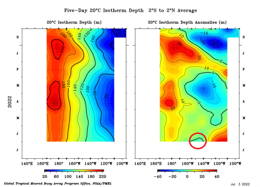
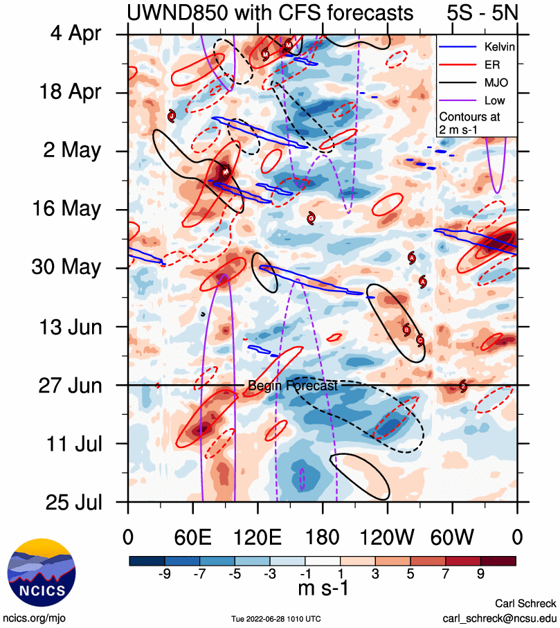
Upwelling Kelvin wave already emerging.
-
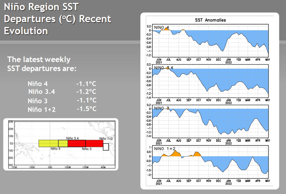
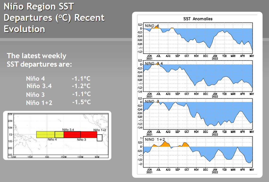
Also, AMJ oni came in at -1.0. Tied with '99 and second coolest AMJ trimonthly since 1950
-
Plenty of ongoing pertinent chatter. According to Klotzbach, current trade burst is one of the strongest observed for this time of year
-
5 hours ago, StormchaserChuck! said:
What's really going on down there??
Yeah the subsurface is the definitely the fly in the ointment as of now. If you look at only it, appears like a Nino about to onset. But every other indicator tells a different story. SOI continues to maintain near-record positive values, trades are absolutely ripping, OLR remains locked in a robust Nina pattern, etc
-
 1
1
-
-
Oh, goodness. What on Earth is going on in here. NO we are not transitioning to El Nino right now. Or this winter. Lmao
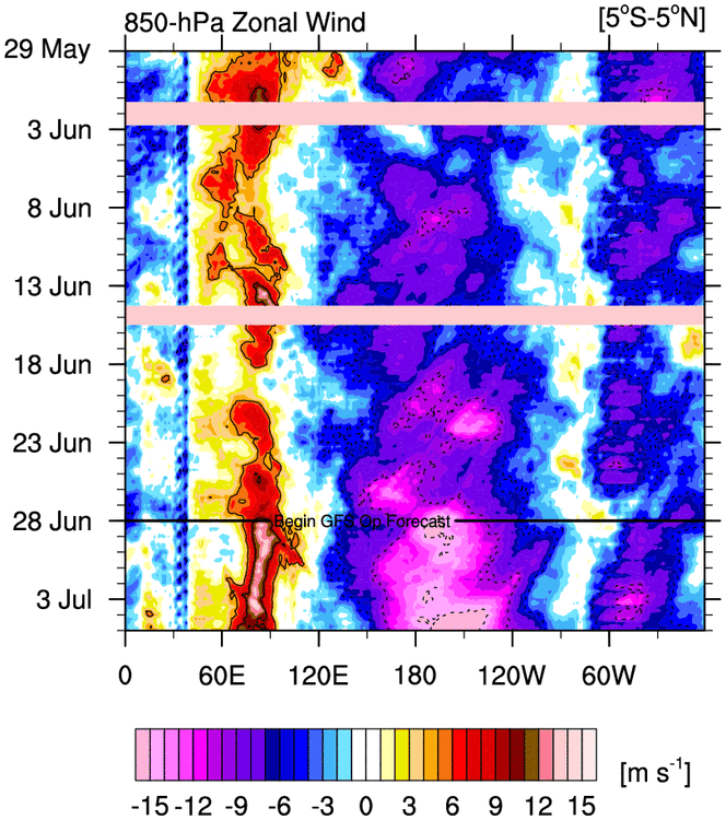

I don't know why people need to hear this, but you're not getting an El Nino with literal 30 kt Pacific trades.
-
4
-
 2
2
-
-
Subsurface is the only indicator giving me pause regarding this Nina
-
1
-
-
-
 coldest anomalies of this year's la nina so far
-
13 hours ago, LibertyBell said:
we might need climate modification to end la nina from what I've been reading about the abnormal warming of the west pac
This might be a permanent condition now
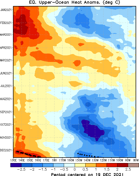
..and due to the increased warmth at depth over the WPac that naturally results from La Nina conditions / enhanced trades, there's ample "fuel" for initiation of robust downwelling Kelvin waves whenever MJO events and associated westerly wind bursts pushes through the Pacific. This happened in December.. and it's generally how La Nina self terminates. Don't see why it would be any different in the future
-
17 minutes ago, Maestrobjwa said:
Is the abnormal warming of the west pac directly correlated to a certain la nina? (And if so, why?)
Anomalous warmth around the Maritime Continent helps to anchor convection and strengthen the Walker circulation via increased ascent over the region. This results in increased subsidence downstream over the EPac (what goes up must come down) and the surface pressure gradient tightens due to the difference between lower pressure over Indonesia and higher pressure over the EPac. The stronger trades that results then pushes the WPac warm pool westward and causes it to "pile up" at depth, amplifying the thermocline.
-
On 3/15/2022 at 4:47 PM, raindancewx said:
This past winter was very cold in some of the ENSO regions, just not the regions CPC uses to determine strength.
It's a huge issue and the largest flaw with ONI, imo. The most egregious recent example is 2018 - a weak el nino if you go by CPC, when the reality - consisting of extreme warmth (both in magnitude and duration) in nino 4, a record positive PMM, 315+ ACE in the EPac, etc... were all indicative of a +ENSO event stronger in magnitude than weak.
On 3/15/2022 at 4:47 PM, raindancewx said:There are a lot of years where the coldest waters can't get past 150W, and the real powerful La Ninas can shut down the convection in Nino 4.
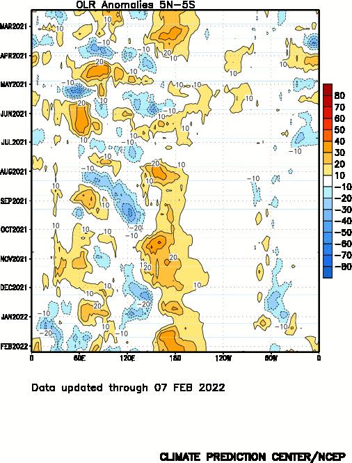
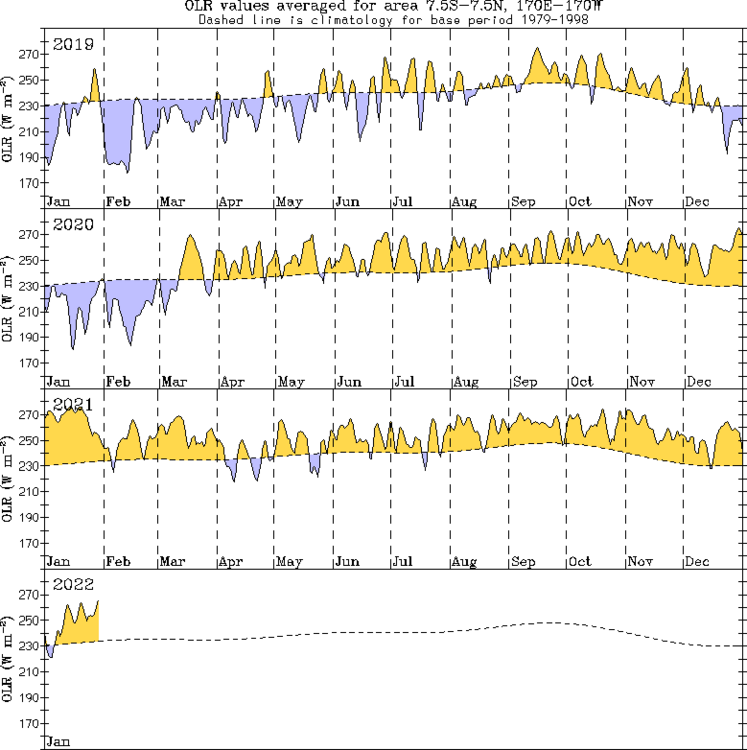
Convection in nino 4 and around the Dateline - as measured by OLR - has been generally shut down since spring of 2020. This winter was no exception
On 3/15/2022 at 4:47 PM, raindancewx said:You can see on Tropical Tidbits that there has been rapid warming this month in Nino 1.2 and Nino 3, as the warmth below the surface in February surfaces. We'll see how things go, but there isn't a clear signal for the next winter by rolling forward the objective closest matches for the winter or the past 12 months.
Yep.. it's the downwelling wave that initiated back in December. While very strong trades prevail over the Dateline, trades are actually weaker than normal in the far east Pacific where this (attenuated) Kelvin wave is beginning to surface. Something to watch.
On a personal note, I would like to say that I appreciate your diligence. Any disagreements we may have had does not change that
")
For the rest of y'all, you should probably mentally prepare yourselves for yet another active hurricane season.
-
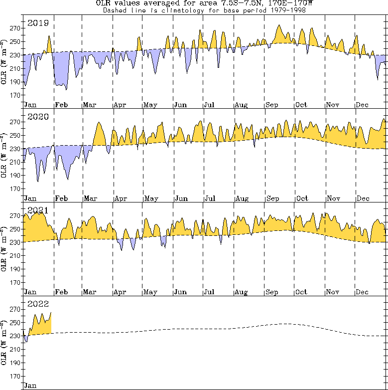
Another piece of evidence is the outgoing longwave radiation - of which a standing wave of positive anomalies remains staunchly centered over the Antimeridian. For all the hooplah about La Nina decaying, the recent MJO pulse barely put a dent in it. Given it spent a month in the destructively interfering phases 6/7 at ~2sigma amplitude, this is quite pathetic. The robustness of the standing wave of suppressed convection continues to speak volumes regarding the strength of the current Nina event.
")
-
2
-
-
>The trades are weaker than last year, just like the SSTs, or the SOI, etc and I don't consider that year a moderate either.
You're the only one, congratulations.
>Especially since the PDO is already reversing
yeah, it only hit near-record lows, you expect that to be sustainable?????? what
>You can dress it up anyway you like but we're likely to hit 15 or more years without a real moderate La Nina at this point.
Uhhh 2010? (or are you [rightfully] counting that event as strong, not moderate)
>It's pretty dumb, in 70 years, you'll have events now called weak El Ninos as near La Ninas with their current process.
Not really... given the Earth has warmed almost 1.5C in the last 70 years.. this is why using raw temperatures like this in a quickly warming climate is quite frankly a fool's errand. ENSO has nothing to do with raw temperatures. It is a change in the Walker Cell caused by RELATIVE differences in temperature.
>Trades are kind of a dumb way to evaluate this stuff anyway
....what??? Trades are the surface component of the Walker Cell? A sustained change in the trades is a sustained change in the Walker Circulation, which is literally the definition of an ENSO event.
>Look at 1988-89. You going to tell me that was a weak La Nina now?
No? I'd tell you that it was a strong La Nina? One of the strongest on record?
>Pick a method and stick with it.
Bad meteorology, no offense. No one index, especially taken at face value, accurately measures something as complex in nature as ENSO. As I have previously stated, the entire picture must be examined.
-
1
-
-
15 hours ago, StormchaserChuck! said:
I keep saying it, we need a 2-3 year El Nino to even out. A strong El Nino, would in the 500mb pattern, be like 72-73 next Winter, alone. +2.8c-+3.0c> would be the only way we do that +PNA/GOA low like 97-98,etc.
I think this happens next year, TBH.
-
1
-
-
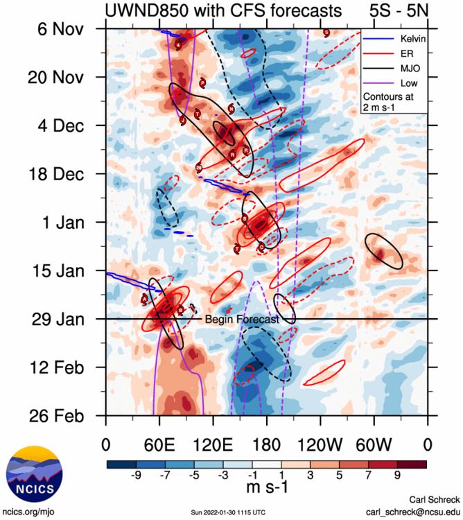
MJO is emerging in the Indian Ocean and constructive interference with Nina is beginning. The trades have returned; you can say goodbye to this downwelling Kelvin wave
Complete opposite of what you want to see if you were rooting for an El Nino. Maybe next year?
-
1
-
-
>I still don't consider this event to be a Moderate.
Well, luckily for us we can go ahead and discard your opinion. This was a very clear moderate if you paid any attention to facts like ocean-atmosphere coupling, and it even reached the arbitrary ONI threshold for a moderate even, too. I bet you also consider the el nino of 2018-19 "weak" as well when it clearly wasn't if you looked at anything besides completely arbitrary nino 3.4 measurements and associated ONI values. Perhaps the biggest issue with your 2017-18 comparison is the complete reversal of the PDO state from that year, another sign of the strength of the recent Nina episode compared to that year. Even if we ignore literally the entire North Pacific, yet another issue is the stronger warmth around the Maritime Continent during this event.. indicating a stronger Walker Cell and easily offsetting the very slightly warmer Central equatorial Pacific during the timeframe you've plotted.
-
3
-
-
La Nina strengthening going into spring just doesn't happen during weak episodes...... it was always a moderate to strong event. Feel free to handwring about arbitrary surface temperature measurements in incredibly specific zones instead of viewing the whole picture.. to your own demise.
-
Window for El nino is quicky closing, now. Trades and strong Nina forcing are returning with a vigor. Look for attenuation of this current downwelling Kelvin wave followed by a reemergence of the cold pool.
3-year nina coming? This gargantuan February trade burst has massive implications for the rest of the calendar year...
-
3
-
-
7 hours ago, StormchaserChuck! said:
This is the important zone
.gif.6a8c2dd67526e4f87f56f244085fe603.gif)
Yep. Need to see if this downwelling Kelvin wave attenuates in this area
-
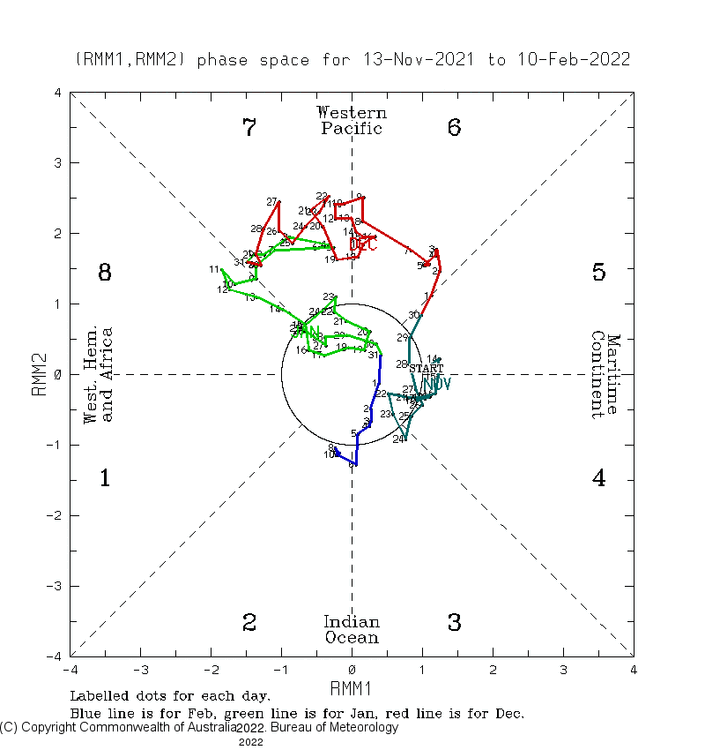
Simultaneous Kelvin waves of both phases noted. >2sigma phase 7 MJO yet trades are neutral to weakly enhanced. Next few months will be interesting!
-
1
-
-
9 hours ago, 40/70 Benchmark said:
It is not in terms of ONI, which is what I think those people are referring to. I know I am. But I agree that this event is definitely more coupled and is obviously a more prominent driver than last year's la nina.
Yeah the atmosphere-ocean coupling has been impressive, along with the PDO this winter. FWIW, MEI also stronger than last year. ONI is quite an arbitrary metric.. but I understand why it's followed.
6 hours ago, EasternLI said:On self destruct for next year?
Now through SPB will be interesting. It would not surprise me if self termination is beginning and the first moderate (or stronger) nino since '15 begins to initiate. Will be fun to monitor the imminent downwelling kelvin wave and whether persisting trades can attenuate - otherwise big implications for next year
-
1
-
-

stronger than last year (despite claims to the contrary....)
-
1 hour ago, 40/70 Benchmark said:
Yea, that isn't going to change this season...the arctic will determine our fate.
This is an ENSO thread...
-
 2
2
-

2022 Atlantic Hurricane season
in Tropical Headquarters
Posted
Yeah I remember their posts right before the most active month ever observed in the Atlantic back in 2017. Same shit, different toilet