

StruThiO
-
Posts
82 -
Joined
-
Last visited
Content Type
Profiles
Blogs
Forums
American Weather
Media Demo
Store
Gallery
Posts posted by StruThiO
-
-
-
Lid's coming off
-
 1
1
-
-
34 minutes ago, ldub23 said:
ill go with the 2009 52.6 ace.
Yeah because we are in a strong El Nino just like 2009!!! Surely there hasn't been record strong Pacific trades, the lowest MEI ever observed except during the La Nina of 2010, historically low ONI etc etc etc etc etc.........................
-
2 hours ago, tiger_deF said:
Given how bearish the board is
Buy low; sell high. My $MDR calls about to print big boy bucks :]
-
2
-
-
1 hour ago, ldub23 said:
Did someone say the super duper awesome fantastic conditions were coming? East Pac says this is a super el nino.
This is horrific for MDR development. A cat 5 cut off low wandering around the middle of the Atlantic. Tropics killer
TICK, TICK, TICK. CSU should have went 6/3/1 for the rest of the season and we might not make that with a very real probability The Fast and Furious watch will be cancelled, no wheel, no euro super ridge, and the east pac popping canes like bees to honey.
k. meanwhile
-
1
-
 1
1
-
 2
2
-
-
12 hours ago, ldub23 said:
All of a sudden a cool subtropics is bad? Ive read the super warm subtropics of years past were bad for the MDR.
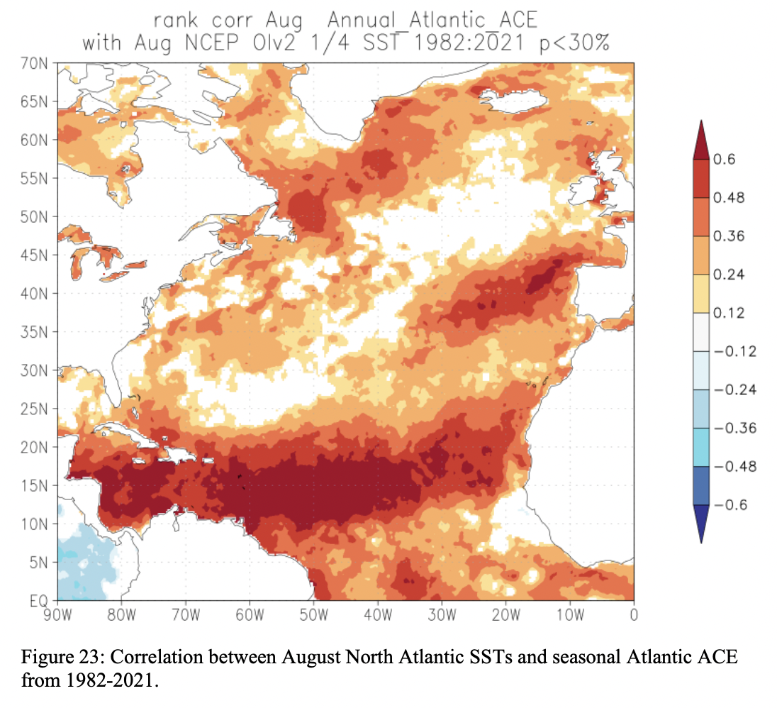
Eastern subtropics exhibits a positive correlation, in the domain of the AMO horseshoe. Western and central subtropics exhibits a far weaker correlation, so you can't group the entire subtropics as one whole like this.
-
1
-
-
8 hours ago, GaWx said:
What does August hold for NS in the basin? Consider these stats
- Since 1995, there has been only one season with no August NS: the super strong El Nino of 1997.
- Since 1995, 24 of 27 (89%) have had not just 2 but 3+ NS in August! Only 1997 (0), 2013 (2), and 2014 (weak El Nino)(2) had fewer than 3 in August.
- 1996, 1998, and 1999 all had 4 NS in August but the first one for all three seasons wasn't til either August 18th or 19th!
- The ENSO analog 2000 (3rd year La Nina) had 4 NS in August.
- Even the pre-1995 ENSO analog of 1985 had 3 NS in August. Actually, all ENSO analogs even going back to the likely underreported years of the 1800s had at least 1 NS in August.Conclusion: Based on history since 1995, you'd have to be bold to go with fewer than 3 NS this August even with the quiet first week or so on the models. I think 3-4 is the most likely with only a slight lean toward 3 NS in August. Even if the first half has none, 1996, 1998, and 1999 all show that 4 NS the 2nd half of the month is doable. In addition, keep in mind that models often don't pick up on a general upturn in activity til the last minute or sometimes even not at all.
This feels like 2019, lol. MDR was a Sahara; comically dry from the Caribbean to Cape Verde, only through the C name and DEAD until late August.. but then what happened? Dorian happened.
-
9 hours ago, GaWx said:
You can forget about that deal. ldub would be back, which is fine with me since it would show (s)he's OK and also it is an entertaining tradition that has always kept the threads active during quiet periods.
At least he taught me a new word today - "vamoose"

-
1
-
-
5 hours ago, so_whats_happening said:
There is hope for it but the fact is as we approach fall we 'normally' strengthen the ENSO state whichever it may be and with us sitting at a previous trimonthly of -1.0 already and the subsurface I have concerns. This just highlights the east coast waters well.
Agree; the modoki look will get shredded once this new upwelling KW propagates to the point of emergence. Will very much look classic again then until the transition away in Winter begins IMO
-
7 hours ago, ldub23 said:
Im surprised this has gone unmentioned.
frankly none of us fixate on operational GFS 300-h forecasts quite like this
-
2
-
-
Trades are only going to continue to rip as the MJO circles back to p4/5..
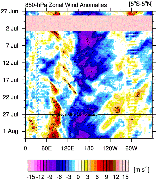
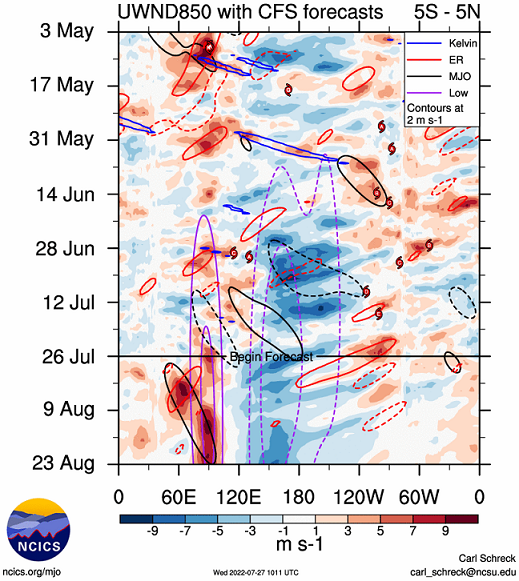
-
Don't really have words for what we are witnessing.. I don't think I've seen anything quite like this before..


-
4
-
-
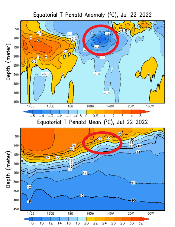
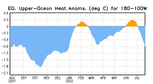
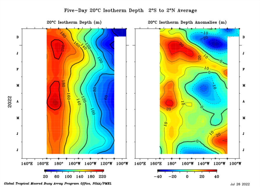
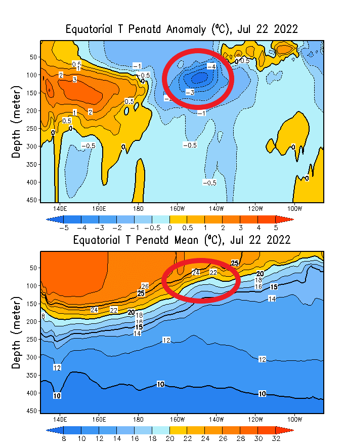
The record-strong easterly wind stress has now resulted in the incredible initiation of an extremely potent upwelling Kelvin wave.
-
1 hour ago, ldub23 said:
Could this end up being the deadest of dead seasons? Another person joins the bandwagon. Beginning of the season now pushed back to sometime in Sept. Has the cane season began and ended in the same month? I would advise CSU to cut numbers down to 10/3/1, but thats only assuming the season actually keeps going in OCT which seems unlikely. Why were the forecasters so horribly wrong about this season? Please chime in on why they did such a horrible job.
If this is what we get in a La Nina please for all thats holy give us a super el nino next season. It cant possibly be any deader than this season was. I think the best idea is for forecasters to dump trying to forecast a season in advance. Instead, just look at the pattern after the start of the season. I was wondering back in early june where all the hype was coming from when it seemed rather obvious the overall pattern was NOT going to produce a season of note. This season was quite dead. Lets hope next season has a bit of moisture in the tropics.
It's July
-
2
-
-
1 hour ago, ldub23 said:
Please i hope for an el nino next season, it cant be worse than the last 2 seasons.
Well, this does seems likely; after 3 years of La Nina it is likely to have exhausted itself and the El Nino response will probably initiate in Winter thru Spring 23
-
1
-
-
2 minutes ago, ldub23 said:
Well, by all means show us some hyperactive maps. MJO, MJO, Where for art thou, MJO?
It's July
-
Just now, ldub23 said:
Euro says the Sahara desert has come to the Atlantic. Is this the look of a hyperactive season?

Yeah surely 1080h will verify! 100% confidence
-
1
-
-
8 hours ago, floridapirate said:
There have been waves of dust coming off the African coast. I'm new to this and to FL...Is this normal activity for this time of the year? I'm told it can dampen tropical activity, is this true?
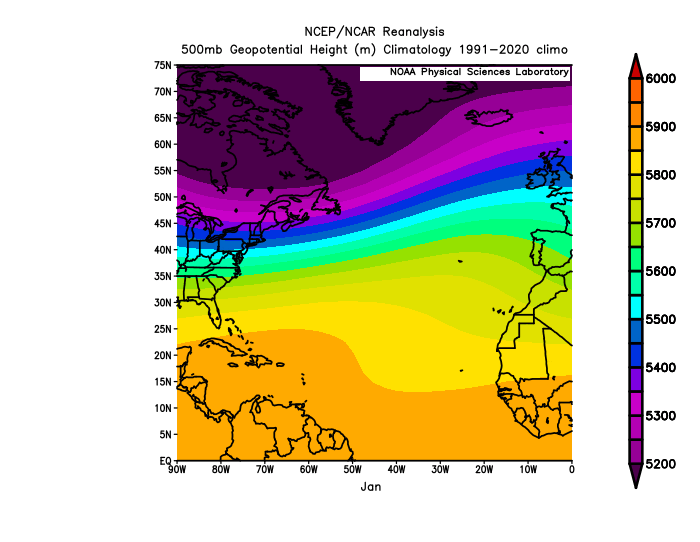
Totally normal. June + July combined don't even account for 10% of climatological hurricane activity.
Here's a gif of monthly 500mb heights, long term mean, 1991-2020 climo. Observe the yearly maxima in ridging in July. This is why right now is the peak of Saharan dust season (and also season cancel season).
It's also why August onwards constitute about 93% of climatological hurricane activity.
-
1
-
-
9 hours ago, ldub23 said:
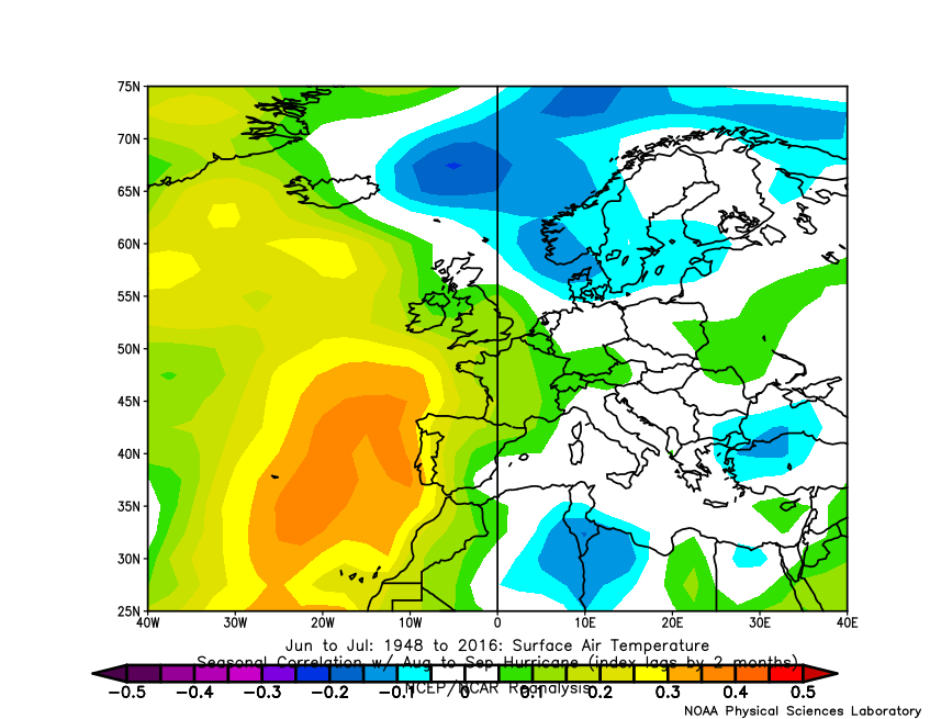
Heat returning to Europe? This might be the reason after the season people use for busted high cane numbers. Everything is interconnected and its possible the same pattern baking Europe is putting a tight snug lid on the tropics.
It makes sense that with a super ridge locked in over Europe it would also have the effect of pumping super duper bone dry dusty air into the tropics. It is rather amazing with a supposed favorable MJO its almost impossible for a tropical cloud to form.
Also, this is demonstrably incorrect. Thanks for playing, though!
-
1
-
1
-
-
On 7/19/2022 at 2:05 PM, ldub23 said:
No change in the pattern as of aug 04. Protective offshore trof, low pressure in northeast. If the euros's big ridge and jb's wheel are going to appear we need to see a pattern reversal rather soon. Another hurricane in the east pac though
It's July
On 7/22/2022 at 12:02 PM, ldub23 said:Atlantic has possible disturbances while the east pac has hurricanes. I do think August will be rightside up, not sideways
It's July
14 hours ago, ldub23 said:I wouldnt say every season. Last season when people were saying it was going to be an east coast season and a long lasting season i disagreed and it wasnt. Right now the MJO is supposedly favorable yet nothing is happening. The MJO isnt going to stay favorable and if it goes negative in mid aug the season might not start till mid sept. If the MJO is favorable it sure isnt producing any clouds.
If anyone still thinks its going to be an active season please chime in.
It's July
9 hours ago, ldub23 said:Heat returning to Europe? This might be the reason after the season people use for busted high cane numbers. Everything is interconnected and its possible the same pattern baking Europe is putting a tight snug lid on the tropics.
It makes sense that with a super ridge locked in over Europe it would also have the effect of pumping super duper bone dry dusty air into the tropics. It is rather amazing with a supposed favorable MJO its almost impossible for a tropical cloud to form.
It's July
-
4
-
1
-
-
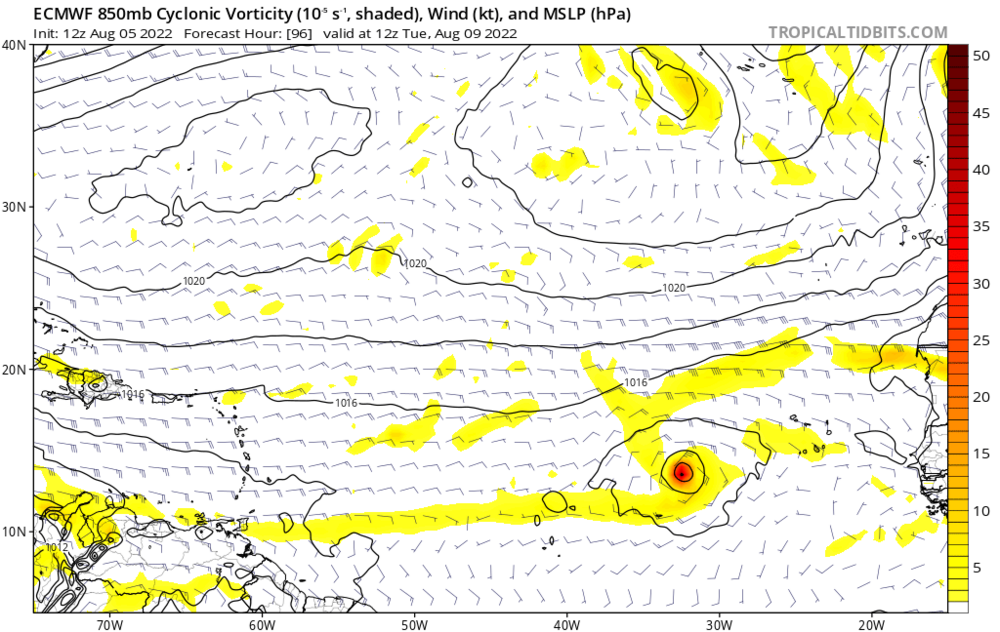
4 hours ago, Windspeed said:12 hours ago, ldub23 said:Maybe things will be going sideways but there will still be nothing of note as long as the eastern super trof is in full force and effect and this map with US protective low pressure over the NW ATL shows absolutely no change in the pattern. No sign at all of the EURO'S NW ATL ridge or JB's newfoundland wheel. They were predicted last season as well and never showed up. This wintertime pattern also means an early end to a late starting season unless we have a rather unlikely pattern reversal. Getting a bit late for that.

This will be a tough nut to crack for things to go sideways. On this satellite picture you can see the offshore protective trof while we can see yet another reinforcement on the way. To me things still appear rightside up.

It's July 17th. If you want to buckle down on what ECONUS mid-level flow will be like on August 17th from what it looks like today, least I remind folks that 2004 saw a very similar pattern in July during a -ENSO. Even our first major hurricane got hooked right into a strong mid-August trough. Then the pattern flipped and all hell broke loose. Interestingly, there was a pretty active June-July in the EPAC that year even with a -ENSO in place. Of course, again, it shut down and an epic WAR/AMO took over by August 31st. That does not mean we'll see a similar outcome, but clearly NINO 4 is bottoming out again and +PNA ridging may not last until the end of Summer.
Minor correction but 2004 was an El Nino year. The import is still very true, as usual weenies gonna weenie
-
1 hour ago, ldub23 said:
Good thing we are in a La Nina or the east pac would be hyperactive. Think we will see something like this in the Atlantic this season?

We will see hurricanes but probably not that 2017-esque. Also I wouldn't trust GFS as far as I can throw it
-
1
-
-
1 hour ago, ldub23 said:
I agree with JB here IF we do have a Newfoundland wheel. The wheel is very important for cane season and winter. IF there really is a wheel then the US coast will be at risk and a big east coast season usually means a cold stormy winter.
how can i get your weenie tag
-
2
-
-
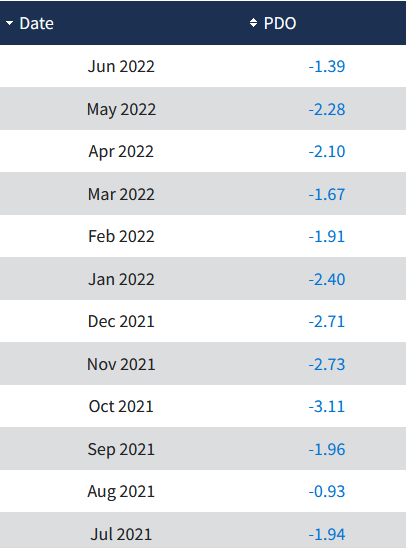
PDO is a regression of North Pacific SSTs. While the "horseshoe" region has warmed, the area extending east of Japan is still blazing hot and is anomalously warmer than the horseshoe. This still yields a net negative PDO, even after the recent warming. June will still be solidly negative although higher than this Spring.
Definitely bullish on a flip to +PDO along with onset of El Nino.. finally.. around Spring 2023.
 2 hours ago, 40/70 Benchmark said:
MJ MEI down to -1.9....lowest since ND 2010 and lowest on record for MJ dating back to 1948.
Def. gives reason for pause on the el nino train of thought.
The El Nino response to this will take time.. but I think could result in the strongest since 2015. Moderate to strong. We are due
-
1
-

2021-2022 ENSO
in Weather Forecasting and Discussion
Posted
Oddball year with a springtime THC collapse