Avon
-
Posts
14 -
Joined
-
Last visited
Content Type
Profiles
Blogs
Forums
American Weather
Media Demo
Store
Gallery
Everything posted by Avon
-
Almost 100 strikes/min with this complex of storms in Michigan, pretty good stuff
-
Nice storm moving towards the north side of Flint, Probably has some good size hail with it
-
Tornado warning issued for Monroe County Michigan A tight couplet moving east
-
Couple tornado warnings issued for Clare, Osceola counties in northern Michigan
-
I think Grand Rapids area may have a greater risk for a tornado as helicity looks pretty good in that area
-
Looks like a rare day three update by spc has a marginal risk out now
-
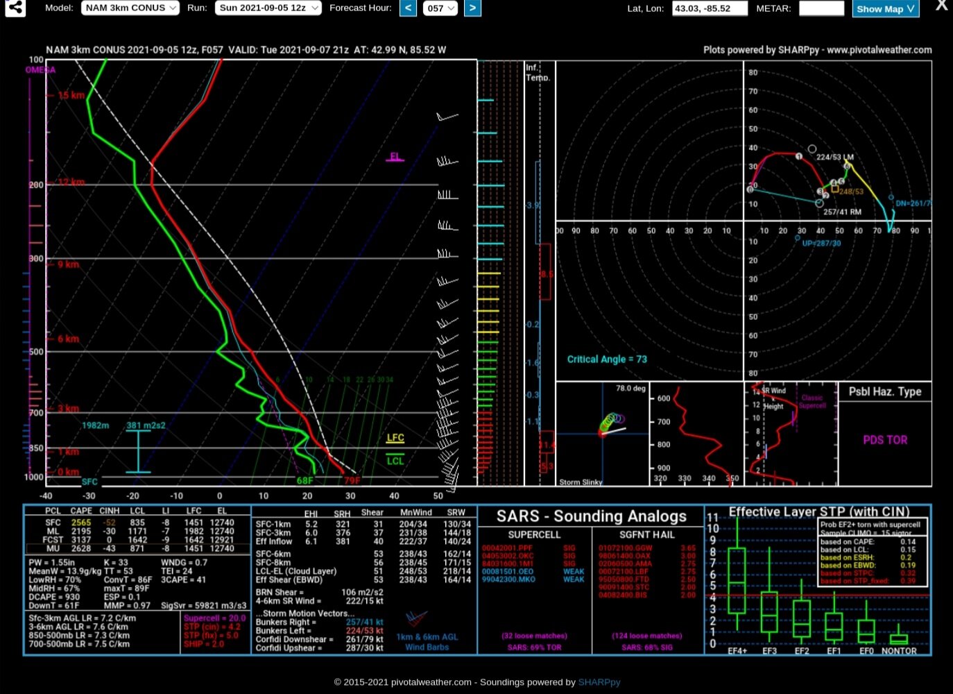
Here is a 12z 3k nam sounding in Grand Rapids for tuesday afternoon
-
The nam is kind of looking interesting for Tuesday afternoon/evening
-
What a disappointment for the past two days in SE Michigan for severe storms. Storms crap the bed twice trying to get here despite good instability. What a waste of energy ☠️
-
Update from Grand Rapids..... Area Forecast Discussion National Weather Service Grand Rapids MI UPDATE... Issued at 1225 PM EDT Wed Jul 28 2021 Latest 12Z guidance is continuing the farther north trend of the most severe convection later tonight, even hinting at the possibility of a derecho impacting much or parts of wrn Lwr MI. Since this is a potentially high impact severe weather event while many folks will be sleeping, communication/messaging the possibility of high/destructive winds this afternoon/evening will be critical. Timing looks to be similar, with potential for a large bow echo sweeping across Lk MI toward or after midnight. Also some potential for the warm advection wing ahead of the main line becoming active a couple hours beforehand. If that does occur, we could have some tornado potential with discrete cells since the warm front will be draped over the area. HRRR has 0-1km SRH of 150-200 m2/s2 with LCLs below 1km. A QLCS-type tornado threat may also develop/exist within the main line. Also of note, in terms of the straight line wind potential, HRRR shows 70 kts at 3 km, of potential descending rear inflow into the back of that line. So some isolated pockets of destructive 80+ mph winds seem plausible later tonight. As far as heavy rainfall/flooding concerns, some intense rainfall rates are likely as the strong/svr convection is coming through tonight, although the progressive nature of the MCS may limit the overall flooding risk. That said, some urban flooding - possibly worthy of areal flood advisories/warnings - may also be needed.
-
Hmmm.....a notable eastward shift in the placement of the mcs on 0z hrrr run. Would put more of Michigan in play if it were to verify
-
The Nam is going wild again with the parameters for this wed/thurs setup like it did saturday, only going to take it with a grain of salt though until further model agreement is established.
-
Quite the severe weather event for southeastern Michigan yesterday. The environment became quite unstable with high cape/strong shear and no interruption from earlier storms. As a result, storms exploded and became tornadic as they moved southeast towards Detroit. Very fun day to watch unfold.
-
Hello I'm just a random person interested in the weather/severe weather The Nam is going bonkers this Saturday with strong instability and decent shear over Michigan while the Gfs/Euro is more subdued. Will have to wait for the models to come to agreement in the coming days right now SPC only has a marginal for day 3 Edited: The nam could also just be an outlier