chrisl
-
Posts
18 -
Joined
-
Last visited
About chrisl

-
About 3" here in Moorestown and currently sitting at roughly 22" for the season. Now at 11 straight days of snow cover which is easily the most consecutive days since I lived in the nothern DC burbs back during 2010 snowmageddon (probably more days than the 2016 storm too though I'd have to look back).
-
Considering the mesos and Euro seem to have a stripe of 5-8 from BWI to ACY and points north I wouldn't be surprised to see warnings in some spots. I see sterling added some in northern MD and I wouldn't be shocked if Mt Holly does that for its part of MD and northern DE. Definitely feels like the heaviest is between the PA TPK and I-70 then down the Ac expressway
-
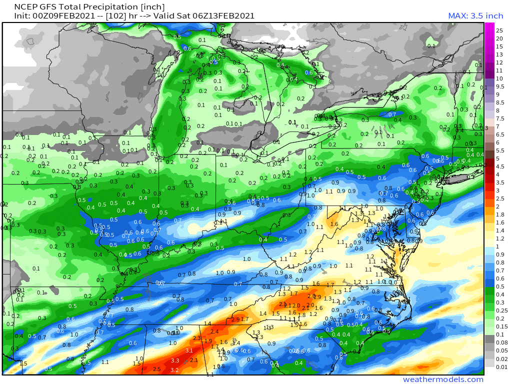
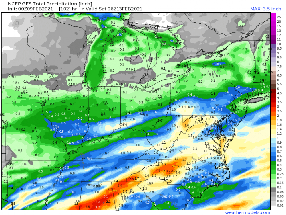
GFS doesnt give us any precip out of tomorrow's event so everything south of turnpike is mid-late week events. Modeling keeps trying to kill the precip from both waves as it gets into Philly metro area. Still think this thing gets even more juice and has a bullseye between I-70 (draw a line due east from Bmore) and Pa TPK.
-
With the trend this winter of everything to be further north and more precip I feel like we're in a good spot for the two waves Wednesday night-Friday. Would much rather be slightly north of the bullseye than in it this far out
-
5 inches here in Moorestown bringing our season total to 21 inches. Very March like storm with areas below the trees being nearly bare because of how much it hung on the trees. Gonna get very icy tonight if side road slush isn't plowed before sunset
-
Still moderately snowing here and holding steady at 33 (thought it would be warmer by now). Snow already compacting so tough to measure but definitely feels like we'll end close to 5". Not bad at all considering earlier with the band setting up west it looked like we'd be in an area of subsidence. The early storm mixing and that hour of small flakes/subsidence between two bands kept us from getting in that 6-10 zone. Feel like PHL heat island will come in way lower than just to the west and the suburbs along the Jersey TPK. Snow here definitely struggled to stick on paved surfaces especially once they were cleared
-
Puking snow here still. Haven't been out to measure yet but I'd estimate around 4"
-
Just measured 1" here though NWS recently said 2" nearby so maybe I'm a little off (last time I was a little over NWS measurements in the area so I guess it all evens out in the end). Either way definitely banding dependent as we knew going in. Just thought the banding would be over 95 instead of 15-25 miles NW. Big flakes are coming back here and the radar seems decent so maybe we'll get to the bottom end of the 3-6. That hour lull of extremely small flakes that weren't piling up definitely cost us. Saw a report near Doylestown of 8.5" which is crazy that's only 24 miles NW of Moorestown
-
Flakes now very small here all of a sudden. Definitely feels like like we'll hedge more towards the low end of most forecasts
-
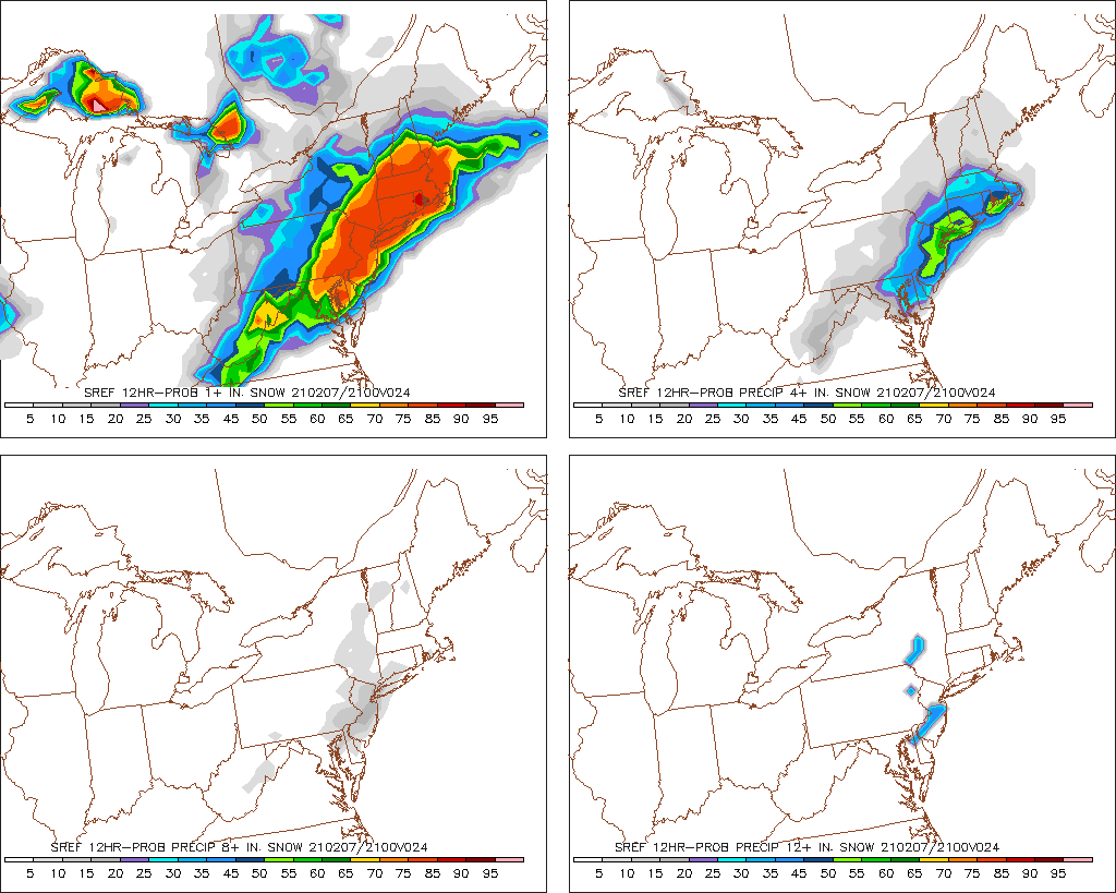
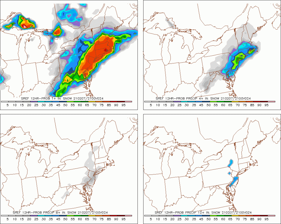
Somehow the SREF has a better chance of 12+ across south Jersey than 8+. I mean I'll take it I guess
-
Everything seems like its kinda SE/less qpf today on modeling. I guess not all bad considering I was worried everything would keep going NW and the rt.130 corridor in Burlington would be mostly rain. Feels like its narrowed in on 95/Jersey tpk being the bullseye 3-6 maybe some isolated spots more
-
FWIW the Euro is way colder than the other models at the surface early Sunday morning before the storm starts. Wondering if its reading the snowpack depth over E.PA better than the American models. Despite the difference most modeling keeps the surface at 32 here during the actual event with soundings showing cold through the column for it to be all snow
-
January 31-February 2, 2021 Major Winter Storm Observations
chrisl replied to Ralph Wiggum's topic in Philadelphia Region
Radar eroding a bit near Trenton so not sure how long we hold the band but probably our biggest flakes of the storm here as we’re finally getting some better dendritic growth. Moderate snow falling currently. Definitely wasn’t expecting another band like this tonight I thought we’d be done until the next round kicks up later tomorrow morning -
January 31-February 2, 2021 Major Winter Storm Observations
chrisl replied to Ralph Wiggum's topic in Philadelphia Region
Looks like about 1.5-2" over the last 3 hours or so. Still a steady light snow currently. Gotta believe we're into double digits now. Will be very interesting to see Mt.Holly's totals update. Looks like modeling has another .4-.5 qpf before it's over so assuming we're at about 10" I'd say final totals should be 12-16" along the 130 corridor in Burlington county -
January 31-February 2, 2021 Major Winter Storm Observations
chrisl replied to Ralph Wiggum's topic in Philadelphia Region
I’m seeing 5-6 for the 130 corridor on the hrrr. A lot of the on air Mets seem to be just saying snow showers tomorrow but the banding on the hi res models looks very good for SNJ. Honestly think some people may be caught off guard tomorrow especially if there’s a lull early morning