
wx_observer
-
Posts
152 -
Joined
-
Last visited
Content Type
Profiles
Blogs
Forums
American Weather
Media Demo
Store
Gallery
Posts posted by wx_observer
-
-
18 minutes ago, Cmass495 said:
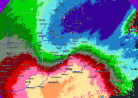
HIGHLIGHTS...

* WE NOW HAVE HIGH CONFIDENCE IN A HISTORIC MAJOR WINTER STORM FOR
 EASTERN NEW ENGLAND. WIDESPREAD 1 TO 2 FT SNOWFALL WITH LOCALIZED
 3 FT IS LIKELY FOR EASTERN MA AND RI ALONG WITH BLIZZARD
 CONDITIONS.
* SNOWFALL RATES COULD REACH 2 TO 4 INCHES PER HOUR AT TIMES DURING
 THE DAY ON SATURDAY WITH POSSIBILITY OF THUNDERSNOW ACROSS EASTERN
 MA AND RI.
* IN ADDITION TO POTENTIAL HISTORICAL SNOWFALL, STRONG WINDS UP TO
 HURRICANE FORCE ESPECIALLY ALONG THE COAST WILL LEAD TO BITTERLY
 COLD WIND CHILLS ON SATURDAY ALONG WITH MINOR TO MODERATE COASTAL
  FLOODING.

DETAILS...

HEAVY SNOWFALL/EXTREME SNOWFALL RATES...

MODELS HAVE NOW COME INTO CONSENSUS FOR A HISTORICAL BLIZZARD TO
IMPACT EASTERN SOUTHERN NEW ENGLAND. EXPLOSIVE CYCLOGENESIS WILL
OCCUR OFF THE MID ATLANTIC COAST TONIGHT, WITH AN IMPRESSIVE 40 MB
PRESSURE DROP IN 24 HOURS AS A SURFACE LOW TRACKS FROM EAST OF THE
CAROLINAS TO THE 70W/40N BENCHMARK. FOR REFERENCE, A BOMB CYCLONE'S
CRITERIA IS A DROP OF 24 MB IN 24 HOURS. AT THIS POINT WITHIN 24
HOURS OF THE STORM, WE ARE NOW IN THE TIME FRAME WHERE THE NAM
GENERALLY PERFORMS WELL DURING AN EAST COAST CYCLOGENESIS EVENT.

WE NOW HAVE HIGH CONFIDENCE IN EXCEPTIONAL TO EXTREME SNOWFALL RATES
WITH THE POSSIBILITY FOR THUNDERSNOW ACROSS EASTERN MA AND RI.
SOMEWHAT LOWER CONFIDENCE IN THE EXACT PLACEMENT OF THE HEAVIEST
BAND, HOWEVER. BOTH NAM AND GFS BUFKIT SOUNDINGS SHOW OVER 50 UNITS

OF OMEGA COINCIDING WITH THE FAVORABLE SNOW GROWTH REGION. GIVEN
THAT A DOUBLE BARREL LOW COULD DEVELOP WITH THE POTENTIAL FOR AN EYE-
LIKE FEATURE AT SOME POINT, WHEREVER THE MESOSCALE SNOW BAND SETS UP
COULD SEE 2 TO 4 INCHES PER HOUR SNOWFALL RATES WITH AN OUTSIDE
CHANCE FOR 5 INCHES PER HOUR ESPECIALLY WHEN ON THE BACKSIDE OF THE
SYSTEM. IF A DEFORMATION BAND CAN PERSIST WHEN THE ARCTIC AIR
ARRIVES LATER IN THE DAY, SNOW TO LIQUID RATIOS (SLRS) COULD BE AS
HIGH AS 20-25 TO 1. THEREFORE, WE FELT CONFIDENT ENOUGH IN THIS
FORECAST PACKAGE TO INTRODUCE AN AREA OF 24 TO 30 INCHES STORM TOTAL
SNOWFALL. IT IS POSSIBLE THAT THIS BAND COULD SET UP FURTHER WEST,
OR THERE MAY BE TWO BANDS OF HEAVY SNOW WITH LESSER AMOUNTS IN
BETWEEN. EITHER WAY, WE ARE CONFIDENT ENOUGH TO GO WITH A BLIZZARD
WARNING FOR THE POTENTIAL OF BLOWING AND DRIFTING SNOW WITH NEAR
ZERO VISIBILITY AT TIMES ACROSS MUCH OF EASTERN MA AND RI.

STRONG WINDS/BLOWING SNOW...

WITH 925MB WINDS AT 65-70 KTS OR 4 TO 5 STANDARD DEVIATIONS ABOVE
NORMAL ACCORDING TO GEFS AND NAEFS SITUATIONAL AWARENESS TABLE AND
COMBINED WITH EXCELLENT MIXING, THERE WILL BE HURRICANE FORCE WIND
GUSTS AT TIMES ALONG THE IMMEDIATE COAST AND 50-60 MPH GUSTS FURTHER
INLAND. THIS WILL TRANSLATE TO WIDESPREAD DRIFTING AND BLOWING OF
SNOW WITH LOCALIZED SNOW DRIFTS OF UP TO 4 FT OR HIGHER. WITH
TEMPERATURES IN THE TEENS TO LOW 20S, WE HAVE HIGH CONFIDENCE IN
RATHER WIDESPREAD BLIZZARD CONDITIONS ACROSS EASTERN MA AND RI,
INCLUDING THE PROVIDENCE TO BOSTON CORRIDOR. BASED ON THE LATEST
GUIDANCE TRENDS, IT IS POSSIBLE THAT THE I-95 OR EVEN THE I-495
CORRIDOR ENDS UP WITH A SECONDARY LOCAL SNOWFALL MAXIMA. THE SILVER
LINING IS THAT BECAUSE WE ARE DEALING WITH DRY POWDERY FLUFF, THERE
IS LESS OF A CONCERN FOR SNOW LOADING ISSUES EXCEPT FOR PARTS OF THE
OUTER CAPE AND NANTUCKET DUE TO THE COASTAL FRONT.

POWER OUTAGE POTENTIAL LOOKS TO BE HIGHEST ACROSS CAPE/ISLANDS,
WHERE THE WARMER TEMPS WOULD LEAD TO HEAVIER AND WETTER SNOW AND
CONSEQUENTLY HIGHER SNOW LOADING. WITH 70 MPH WINDS, POWER OUTAGES
WILL BE LIKELY.

THERE IS SOMEWHAT LOWER CONFIDENCE HOW FAR WEST THE HEAVY SNOW
OVERSPREADS AND THIS IS SOMETHING THAT WE CANNOT BE ENTIRELY SURE
UNTIL THE MESOSCALE BAND SETS UP AS THE STORM GETS GOING TOMORROW
MORNING. WHILE WE DO THINK THAT PLYMOUTH COUNTY IS STILL GOING TO
END UP WITH ONE OF THE HIGHEST TOTALS FOR THIS STORM, HOWEVER, THE
SLRS MAY BE AFFECTED BY THE DENDRITIC GROWTH ZONE'S LESS THAN IDEAL
COINCIDENCE WITH THE BEST OMEGA RESULTING IN RIMING AND THE FACT
THAT THE HURRICANE FORCE GUSTS COULD BREAK UP DENDRITES.
That’s about as strongly worded as I’ve seen in a forecast discussion
-
Even that area north of the warning is looking pretty feisty near Norwalk and heading towards Bridgeport. No warning there yet though.
-
 1
1
-
-
Was watching this cell south of Stamford...just got TOR warning
-
That's some unusually clean floodwater at the airport...
-
1
-
-
Crazy, how this just lit up over NYC in the last few frames

-
2
-
-
26 minutes ago, TauntonBlizzard2013 said:
West Nile was just found in Halifax, I’m spraying there tomorrow. The large amounts of rain and standing water definitely elevated the risk of EEE
Worcester just had positive samples for West Nile too
-
51 minutes ago, dendrite said:

Mixing in with some whiffs of green near Temple now...
-
Is the tornado threat largely ahead of the main rain band--or within it too?
-
1
-
-
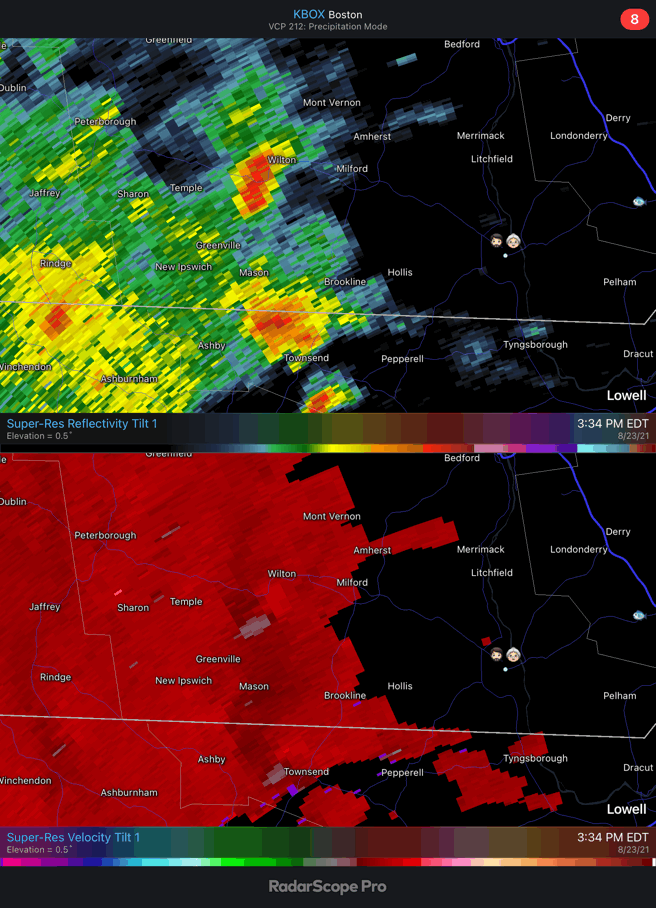
Severe Weather Statement National Weather Service Boston/Norton MA 1207 PM EDT Mon Aug 23 2021 MAC017-027-231630- /O.CON.KBOX.TO.W.0005.000000T0000Z-210823T1630Z/ Worcester MA-Middlesex MA- 1207 PM EDT Mon Aug 23 2021 ...A TORNADO WARNING REMAINS IN EFFECT UNTIL 1230 PM EDT FOR EAST CENTRAL WORCESTER AND CENTRAL MIDDLESEX COUNTIES... At 1206 PM EDT, a confirmed tornado was located over Berlin, or near Marlborough, moving north at 15 mph. This storm has had a history of producing a brief tornado and could continue to produce brief tornadoes. HAZARD...Damaging tornado. SOURCE...Weather spotters confirmed tornado. At 1145 AM a tornado was reported west of I-495 in Marlborough. IMPACT...Flying debris will be dangerous to those caught without shelter. Mobile homes will be damaged or destroyed. Damage to roofs, windows, and vehicles will occur. Tree damage is likely. Locations impacted include... Marlborough, Hudson, Northborough, Clinton, Lancaster, Sterling, Harvard, Boxborough, Bolton, Boylston and Berlin. PRECAUTIONARY/PREPAREDNESS ACTIONS... To repeat, a tornado is on the ground. TAKE COVER NOW! Move to a basement or an interior room on the lowest floor of a sturdy building. Avoid windows. If you are outdoors, in a mobile home, or in a vehicle, move to the closest substantial shelter and protect yourself from flying debris. Motorists should not take shelter under highway overpasses. If you cannot safely drive away from the tornado, as a last resort, either park your vehicle and stay put, or abandon your vehicle and lie down in a low lying area and protect yourself from flying debris. && LAT...LON 4232 7156 4231 7162 4245 7174 4249 7155 TIME...MOT...LOC 1603Z 174DEG 12KT 4240 7159 TORNADO...OBSERVED MAX HAIL SIZE...0.00 IN -
1 minute ago, Ginx snewx said:

That would be it...I have the same app--wonder why I'm not seeing that green
-
Not seeing a clear sig on the velocity like was there last week though
-
Was just about to post that...my son is in camp in that area too. Not a great week to live in Clinton, huh?
-
1
-
-
12 minutes ago, Ginx snewx said:
Um gravity waves, sun, instability, gonna have to watch this afternoon here
Special Weather Statement National Weather Service Boston/Norton MA 1130 AM EDT Mon Aug 23 2021 MAZ004-005-012-231615- Southern Worcester MA-Central Middlesex County MA- Northern Worcester MA- 1130 AM EDT Mon Aug 23 2021 ...Developing thunderstorm over portions of east central Worcester and south central Middlesex Counties... At 1130 AM EDT, Doppler radar was tracking a strong thunderstorm over Westborough, or near Marlborough, moving north at 15 mph. This storm may produce funnel clouds. HAZARD...Winds to 40 mph. SOURCE...Radar indicated. IMPACT...Gusty winds could knock down tree limbs and blow around unsecured objects. Locations impacted include... Marlborough, Hudson, Westborough, Hopkinton, Northborough, Clinton, Southborough, Stow, Bolton, Boylston and Berlin. PRECAUTIONARY/PREPAREDNESS ACTIONS... This storm may intensify, so be certain to monitor for additional information and possible warnings from the National Weather Service. && LAT...LON 4226 7154 4224 7159 4242 7172 4246 7152 TIME...MOT...LOC 1528Z 171DEG 13KT 4228 7157 MAX HAIL SIZE...0.00 IN MAX WIND GUST...40 MPH-
1
-
-
1 hour ago, radarman said:
This happened to ours too. We cut the flowers to take the weight off and help the stems stand up again. We'll see if they can be saved.
If they're annual you may have to put the seed heads back in that same area after the cut flowers die for them to grow back. Perennial ones die off with the frost every year anyway, so they should just grow back next spring.
-
7 minutes ago, Snugharbor said:
if it doesn't happen to them they don't give a bleep.
The sad truth is…aren’t most people like this?
-
 1
1
-
-
Henri is in no hurry to go anywhere…9 mph forward speed.
-
1 minute ago, DavisStraight said:
Just went outside and the wind's blowing pretty good here. It seems to only be when you get heavy rain and it mixes that you get the wind.
That’s what we’re getting too. Waves of pretty blustery wind—maybe 30-40 mph ish…then calm.
-
For all those out there meh-ing and poking fun at this storm…there are actually folks that do have some significant damage to deal with. My folks just south of Worcester just had a very large tree fall on their house, well away from the center.
-
 2
2
-
-
Wow, that’s a pretty dramatic zero hour track shift
-
1 minute ago, DotRat_Wx said:
It's nothing more than a light shower.
You've outsmarted all of the media and meteorologists tracking the storm
And whomever decided that a tropical system with sustained winds of 39+ was worthy of a warning to begin with…
-
3 minutes ago, ORH_wxman said:
might get some decent winds here.
I’m thinking that too. Already a bit of a steady breeze here and the bedroom doors have slammed shut a few times in central ma. Anyone looking to be impressed by a Gloria or bob type storm will be disappointed. But with a highly populated area and widespread lower level impacts I’d be hesitant to call this a meh storm. We just saw what Fred did around here and it had been over land for a few days already.
-
1 minute ago, moneypitmike said:
Perhaps they were referring to 50-69% of their customers in coastal RI.
This was from last night before the nudge east. Maybe they’re overcooking it with the intent to “over deliver” on restoration.
-
Did I just hear this right on wcvb? Eversource saying that 50-70% of its customers will be without power for 1-3 weeks?! Maybe I need another cup of coffee…

-
10 minutes ago, Prospero said:
I wonder up north what is the worst issue of no power.
In winter it’s not having heat. In summer…for me…it’s the sump pump not working and the basement flooding. The rest is a nuisance but manageable.
-
2
-

Powerful Multi-regional/ multi-faceted east coastal storm now above medium confidence: Jan 29 -30th, MA to NE, with snow and mix combining high wind, and tides. Unusual early confidence ...
in New England
Posted
A pretty impressive drift happens on the other side of my fence in the neighbors yard during these potent nor’easters. It goes from bare ground near their house, to nearly 6’ high at the fence. Hope to see it again tomorrow—it’s a definitive sign of a 5 star snowstorm.