
wx_observer
-
Posts
152 -
Joined
-
Last visited
Content Type
Profiles
Blogs
Forums
American Weather
Media Demo
Store
Gallery
Posts posted by wx_observer
-
-
29 minutes ago, Brian5671 said:
What a summer for storms...
What's so odd is that most of them didn't come through to put an end to a stretch of really hot, humid 90+ degree weather. That's usually what drives most of the severe storms around here, if it's not a remnant of a hurricane anyway.
Actually, that is more what it reminds me of. How a transitioning tropical storm might kick off severe weather.
-
And another TOR warning...looks like what started in Scituate is planning to end in Scituate....
-
That TOR warning appears to have a confirmed tornado with it, according to the text in the warning
-
Something looks like it wants to get going near Barre
-
8 minutes ago, weatherwiz said:
Hoping a new warning will be issued soon
Wish granted...
-
 1
1
-
-
1 minute ago, mob1 said:
Impressive couplet for this region

And fairly long lived too
-
2
-
-
2 minutes ago, weatherwiz said:
I wonder if storm mode was a big driver in SVR vs. TOR
They took the other MD down altogether. I wonder if they're updating it.
-
The wind really picked up here in Central MA. If clouds could get a speeding ticket, today would fill the end of month quotas.
I wouldn't want to be under any weakened trees with how saturated the ground is, even with the non-thunderstorm winds out there right now.
-
16 minutes ago, ineedsnow said:
suns out
Here too
-
44 minutes ago, weatherwiz said:
Be curious to see if its a Tornado Watch. Might be a consideration since its purple
And they posted a separate MD for SCT / NY / NJ. Would have probably made a single MD for the whole area if the threat profile was the same.
-
1
-
-
6 minutes ago, BrianW said:
2.87. We flood.


Looks like you have some additional hose there--is there a reason you didn't pull the hose as far away from the house as possible?
-
 1
1
-
-
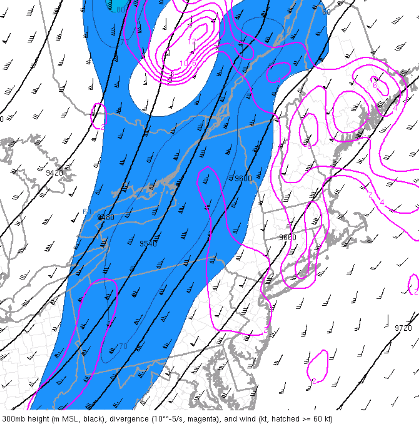
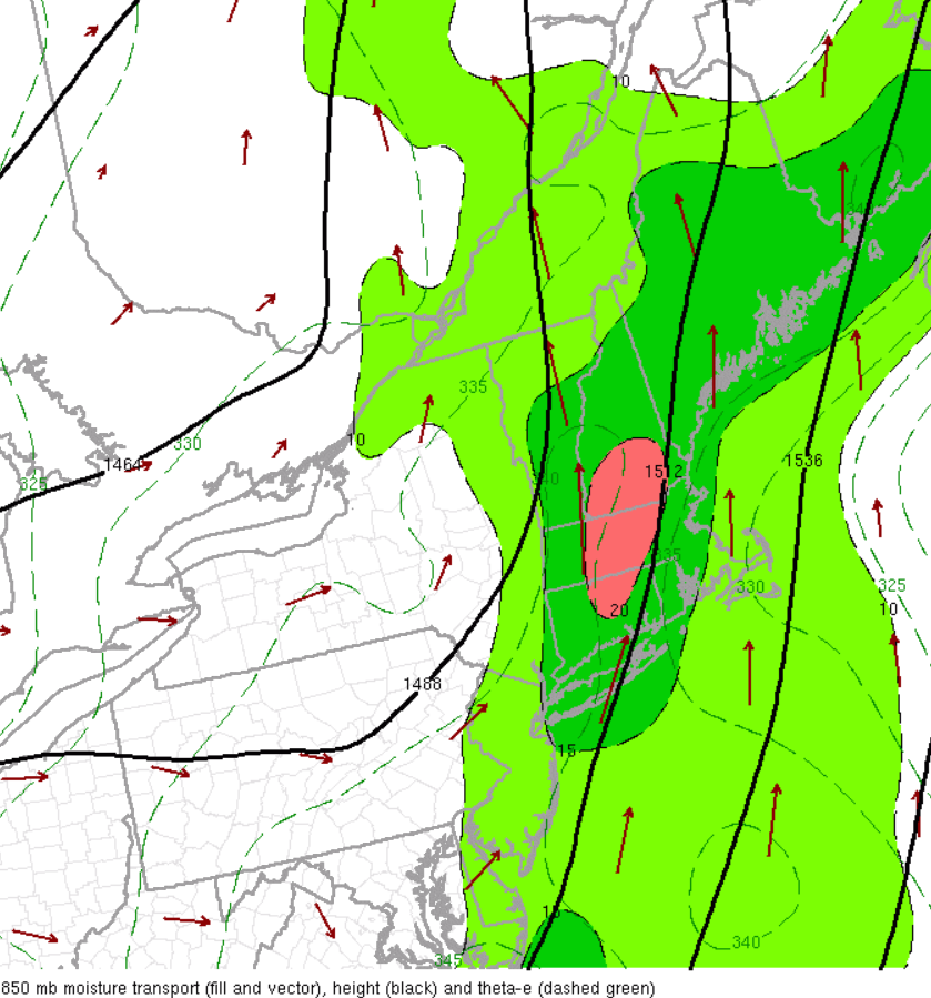
2 minutes ago, weatherwiz said:
upper-level divergence should continue to increase through the afternoon as the core of the jet streak continues lifting northeast

Core of llvl jet is overhead now and should remain pretty strong into the early afternoon with moisture transport maximized right over the region

While everything was relatively progressive earlier the east trend has definitely slowed quite a bit. Really watching down across New Jersey where precipitation is filling in and convection is beginning to blossom based on satellite.
Is that area in red at highest risk for flash flooding?
-
19 minutes ago, HoarfrostHubb said:
Wa wa Wachusett

Was kind of surprised to not see this get warned.
-
1
-
-
2 minutes ago, HIPPYVALLEY said:
These were the TV met calls:

Not sure I understand the rationale for those map projections used by fox 25 or NECN.
-
Getting a bit darker now in ORH and snow picking up. 32 F light-moderate snow.
-
1
-
-
1 minute ago, joey2002 said:
00z GFS last night also had that rip-off zone over us. It was off in other spots though

Looks like it captured the location of that dry slot really well though
-
This dry slot is brutal...do we get in on the back end that's in NY state on its way out?
-
Gah--ORH getting in on that dry slot
-
Are my eyes deceiving me--or is that double low actually panning out.
-
1 minute ago, ineedsnow said:
got to be close to 3" an hour now just dumping!!!
the metamorphosis of ineedsnow into ineedbulldozerandchainsawnow
-
 2
2
-
-
.NEAR TERM /THROUGH TONIGHT/... 10 AM update... Extreme impacts being felt across the Berkshires with widespread power outages and travel disruptions. Locally up to 2 feet of snow has already been reported. Power outages not as widespread in northern Worcester county where around a foot of snow has fallen as of 8 am. However, heaviest of the snow will continue into the afternoon in this area along the northern periphery of the mid level low with low level jet providing strong moisture advection and forcing for ascent. An additional 8-12 inches is expected across the Berkshires and northern Worcester hills. Max snowfall of 20-30 inches in the Berkshires with locally up to 3 feet not out of the question. In the northern Worcester Hills 1-2 feet is expected with worsening conditions through the day. -
14 minutes ago, MegaMike said:
The most recent public information statement from KBTV, KBOX, KGYX, and KALY. Some impressive totals already.
------------------------------------------------------------
***KBOX***Location Amount Time/Date Provider
...Connecticut...
...Hartford County...
7 WNW Granby 11.3 in 0815 AM 03/14
Windsor Locks 4.4 in 0814 AM 03/14 ASOS...Massachusetts...
...Franklin County...
Hawley 24.0 in 0802 AM 03/14 CO-OP Observer
Greenfield 5.8 in 0725 AM 03/14 CO-OP Observer
1 W Orange AP 3.0 in 0858 AM 03/14...Hampden County...
Blandford 16.0 in 0845 AM 03/14
Granville 14.5 in 0845 AM 03/14
2 NW Montgomery 8.0 in 0705 AM 03/14
Southwick 6.0 in 0845 AM 03/14 Emergency Mngr
2 SW Chicopee 4.5 in 0711 AM 03/14...Hampshire County...
1 ESE Plainfield 24.0 in 0859 AM 03/14
1 ESE Plainfield 20.0 in 0741 AM 03/14...Middlesex County...
Ashby 16.5 in 0905 AM 03/14
1 WNW Pepperell 4.0 in 0704 AM 03/14
2 SSE Dunstable 3.5 in 0832 AM 03/14...Worcester County...
Templeton 14.0 in 0910 AM 03/14
2 NNW Sterling 13.3 in 0901 AM 03/14
1 WNW Holden 13.0 in 0838 AM 03/14
Ashburnham 12.7 in 0745 AM 03/14 CO-OP Observer
2 NNW Sterling 11.5 in 0729 AM 03/14
1 NE Lunenburg 10.1 in 0821 AM 03/14
Lunenburg 10.0 in 0905 AM 03/14
1 N Rutland 8.0 in 0717 AM 03/14
Worcester AP 4.5 in 0815 AM 03/14 ASOS
1 NNW Lancaster 4.5 in 0755 AM 03/14
------------------------------------------------------------
***KGYX***Location Amount Time/Date Provider
...Maine...
...Franklin County...
Farmington 4.8 NNW T in 0900 AM 03/13 COCORAHS...New Hampshire...
...Belknap County...
2 WSW Meredith 2.0 in 0213 AM 03/14 Trained Spotter...Carroll County...
1 N Madison 5.5 in 0619 AM 03/14 Trained Spotter...Cheshire County...
Walpole 5.5 in 0618 AM 03/14 Public
2 SW Keene 2.0 in 0707 AM 03/14 Trained Spotter...Coos County...
4 NNW Whitefield 2.6 in 0626 AM 03/14 Trained Spotter...Hillsborough County...
2 WNW Windsor 11.0 in 0641 AM 03/14 Trained Spotter
2 N Francestown 10.0 in 0728 AM 03/14 Trained Spotter
2 N New Boston 8.0 in 0734 AM 03/14 Trained Spotter
2 N Brookline 6.2 in 0711 AM 03/14 Public
3 N Hillsborough 6.0 in 0107 AM 03/14 Trained Spotter
2 S New Boston 5.6 in 0729 AM 03/14 Trained Spotter...Merrimack County...
3 E Tilton 2.5 in 0745 AM 03/14 Public
Concord Municipal Airport 0.7 in 0717 AM 03/14 ASOS...Rockingham County...
3 ENE Derry 5.0 in 0720 AM 03/14 Trained Spotter
Nottingham 1.2 S T in 0830 AM 03/13 COCORAHS...Strafford County...
2 ENE Northwood 2.0 in 0616 AM 03/14 Trained Spotter
------------------------------------------------------------
***KALY***LOCATION TOTAL TIME/DATE COMMENTS
SNOWFALL MEASURED
(inches)CONNECTICUT
...Litchfield County...
Lakeville 4.0 730 AM 3/14 Amateur RadioMASSACHUSETTS
...Berkshire County...
Windsor 25.0 857 AM 3/14 Twitter
3 S Sandisfield 15.6 902 AM 3/14 Trained Spotter
2 ENE Pittsfield 11.4 800 AM 3/14 Amateur Radio
Cheshire 7.5 800 AM 3/14 Amateur Radio
Lenox 7.0 630 AM 3/14 Social Media
Adams 6.5 800 AM 3/14 Amateur Radio
Lenoxdale 6.5 800 AM 3/14 Amateur Radio
Williamstown 3.5 728 AM 3/14 TwitterNEW YORK
...Albany County...
CLARKSVILLE 10.0 800 AM 3/14 Elevation 1290 ft
1 NE Guilderland 8.0 700 AM 3/14 Amateur Radio
Albany Intl AP 6.0 800 AM 3/14 ASOS
Albany 5.8 905 AM 3/14 Meteorologist
Boght Corners 5.8 755 AM 3/14 NWS Employee
Colonie 5.5 735 AM 3/14 Trained Spotter
New Scotland 5.0 640 AM 3/14 Amateur Radio...Columbia County...
Austerlitz 10.0 842 AM 3/14 WeatherNet6
Taghkanic 7.0 831 AM 3/14 WeatherNet6
Ancramdale 4.0 649 AM 3/14 WeatherNet6
Germantown 4.0 812 AM 3/14 WeatherNet6...Dutchess County...
Rhinebeck 6.0 733 AM 3/14 Facebook
Red Hook 4.0 703 AM 3/14 WeatherNet6
Poughquag 4.0 745 AM 3/14 Public...Greene County...
5 SW Palenville 18.0 717 AM 3/14 Facebook
3 SSW Tannersville 16.0 630 AM 3/14 Facebook
Greenville Center 11.0 901 AM 3/14 WeatherNet6
West Kill 10.0 822 AM 3/14 WeatherNet6
Cairo 6.0 632 AM 3/14 WeatherNet6
Halcott Center 6.0 826 AM 3/14 WeatherNet6
Catskill 4.0 725 AM 3/14 WeatherNet6...Hamilton County...
Wells 10.0 700 AM 3/14 Amateur Radio
7 ENE Piseco 7.6 700 AM 3/14 Amateur Radio
Piseco 7.0 816 AM 3/14 WeatherNet6
Long Lake 3.5 700 AM 3/14 Amateur Radio
Inlet 3.0 705 AM 3/14 Trained Spotter...Herkimer County...
Ohio 6.4 855 AM 3/14 Amateur Radio
3 E Middleville 5.0 703 AM 3/14 Trained Spotter
Dolgeville 4.5 835 AM 3/14 Amateur Radio
Herkimer 4.0 850 AM 3/14 Amateur Radio
Ilion 4.0 700 AM 3/14 Amateur Radio...Montgomery County...
Hessville 8.3 857 AM 3/14 WeatherNet6
Glen 8.0 801 AM 3/14 WeatherNet6
Amsterdam 6.8 759 AM 3/14 WeatherNet6
Canajoharie 6.0 830 AM 3/14 Facebook
3 NNE Sprakers 3.5 740 AM 3/14 Amateur Radio
Fonda 3.1 723 AM 3/14 WeatherNet6...Rensselaer County...
1 NW Wyantskill 12.0 815 AM 3/14 Amateur Radio
Brunswick 11.5 855 AM 3/14 Amateur Radio
1 N Sycaway 9.1 800 AM 3/14 0.96 inches liquid
1 N North Greenbush 8.5 726 AM 3/14 Trained Spotter
Petersburg 8.0 826 AM 3/14 WeatherNet6
Berlin 7.5 703 AM 3/14 Facebook
East Greenbush 7.5 630 AM 3/14 Trained Spotter
Speigletown 4.0 721 AM 3/14 WeatherNet6
Hoosick Falls 3.2 806 AM 3/14 WeatherNet6...Saratoga County...
Providence 12.5 813 AM 3/14 Elevation 1300 ft
Clifton Park 6.5 710 AM 3/14 WeatherNet6
Galway 6.2 754 AM 3/14 WeatherNet6
Ballston Spa 4.5 632 AM 3/14 WeatherNet6
Ballston Lake 4.5 728 AM 3/14 WeatherNet6
Saratoga Springs 4.0 813 AM 3/14 WeatherNet6...Schenectady County...
Delanson 14.0 919 AM 3/14 WeatherNet6
Schenectady 6.0 650 AM 3/14 WeatherNet6
1 SSW Aqueduct 6.0 720 AM 3/14 NWS Employee
1 NNE Hawthorne Hill 6.0 830 AM 3/14 NWS Employee
Niskayuna 5.5 820 AM 3/14 Amateur Radio
Duanesburg 5.0 728 AM 3/14 WeatherNet6
Pattersonville 5.0 732 AM 3/14 Meteorologist...Schoharie County...
Jefferson 13.0 800 AM 3/14 Elevation 1900 ft
Middleburgh 8.2 630 AM 3/14 WeatherNet6
Richmondville 8.0 751 AM 3/14 WeatherNet6...Ulster County...
Plattekill 6.1 730 AM 3/14 Trained Spotter
Rosendale 3.5 815 AM 3/14 Public...Warren County...
3 WSW North Creek 10.5 804 AM 3/14 Twitter
Lake Luzerne 6.2 636 AM 3/14 WeatherNet6
Queensbury 5.5 841 AM 3/14 WeatherNet6...Washington County...
Hartford 11.5 910 AM 3/14 Trained Spotter
Hebron 6.0 813 AM 3/14 WeatherNet6
Granville 4.0 713 AM 3/14 WeatherNet6
Whitehall 1.0 731 AM 3/14 WeatherNet6VERMONT
...Bennington County...
Pownal 11.0 741 AM 3/14 Facebook
Landgrove 9.0 710 AM 3/14 WeatherNet6
3 NNE Arlington 5.5 732 AM 3/14 Trained Spotter
West Arlington 2.0 628 AM 3/14 WeatherNet6...Windham County...
Windham 21.4 900 AM 3/14 CoCoRaHS
Brattleboro 8.0 730 AM 3/14 Facebook
**********************24 HOUR SNOWFALL**********************LOCATION 24 HOUR TIME/DATE COMMENTS
SNOWFALL MEASURED
(inches)CONNECTICUT
...Litchfield County...
2 WNW Warren 4.0 700 AM 3/14 CoCoRaHS
3 WNW New Milford 1.0 700 AM 3/14 CoCoRaHS
2 SSW Woodbury Cente 0.5 700 AM 3/14 CoCoRaHS
5 SSW New Milford 0.5 730 AM 3/14 CoCoRaHSMASSACHUSETTS
...Berkshire County...
1 NNW Cheshire 7.2 700 AM 3/14 CoCoRaHS
2 NW Sheffield 2.8 700 AM 3/14 CoCoRaHSNEW YORK
...Albany County...
3 SSW Altamont 14.8 808 AM 3/14 CoCoRaHS
4 NW Altamont 10.5 700 AM 3/14 CoCoRaHS
3 SW Glenmont 5.5 700 AM 3/14 CoCoRaHS
1 SW Albany 5.5 700 AM 3/14 CoCoRaHS
NWS Albany 4.1 800 AM 3/14 CoCoRaHS...Columbia County...
1 SW Chatham 8.5 700 AM 3/14 CoCoRaHS
3 N Valatie 7.2 700 AM 3/14 CoCoRaHS
N Ancramdale 6.5 700 AM 3/14 CoCoRaHS
1 S Valatie 5.5 700 AM 3/14 CoCoRaHS
1 E Germantown 3.7 700 AM 3/14 CoCoRaHS...Dutchess County...
3 NE Lagrangeville 5.8 700 AM 3/14 CoCoRaHS
3 SE Millbrook 5.6 700 AM 3/14 CoCoRaHS
1 NNE Red Hook 4.0 700 AM 3/14 CoCoRaHS
3 N Rhinebeck 3.6 700 AM 3/14 CoCoRaHS...Fulton County...
Gloversville 7nw 8.1 700 AM 3/14 Co-Op Observer
1 NE Northville 7.0 645 AM 3/14 CoCoRaHS
1 N Northville 5.2 635 AM 3/14 CoCoRaHS...Greene County...
1 E Greenville 11.0 700 AM 3/14 CoCoRaHS
3 E Freehold 9.5 700 AM 3/14 CoCoRaHS
2 N Lexington 9.0 700 AM 3/14 CoCoRaHS
WNW Athens 2.6 730 AM 3/14 CoCoRaHS...Hamilton County...
Indian Lake 9.3 750 AM 3/14 Co-Op Observer
10 SSW Speculator 8.5 700 AM 3/14 CoCoRaHS
2 WSW Lake Pleasant 7.6 655 AM 3/14 CoCoRaHS
1 N Long Lake 4.4 700 AM 3/14 CoCoRaHS...Herkimer County...
3 NE Schuyler 4.5 745 AM 3/14 CoCoRaHS...Montgomery County...
2 WSW Hessville 8.3 800 AM 3/14 CoCoRaHS
1 NNW Amsterdam 6.0 704 AM 3/14 CoCoRaHS
SE Fort Plain 2.3 700 AM 3/14 CoCoRaHS...Rensselaer County...
7 NE Troy 10.4 700 AM 3/14 CoCoRaHS
1 E Troy 10.0 700 AM 3/14 CoCoRaHS
2 NNE Troy 9.1 800 AM 3/14 CoCoRaHS
3 SW Stephentown 5.0 700 AM 3/14 CoCoRaHS...Saratoga County...
4 WNW Rock City Fall 12.5 740 AM 3/14 CoCoRaHS
3 ESE Ballston Spa 8.0 845 AM 3/14 CoCoRaHS
2 W Greenfield Cente 7.0 800 AM 3/14 CoCoRaHS...Schenectady County...
1 NE Niskayuna 5.9 700 AM 3/14 CoCoRaHS
3 SSE Niskayuna 5.0 700 AM 3/14 CoCoRaHS
2 ENE Schenectady 4.5 700 AM 3/14 CoCoRaHS
1 NW Scotia 3.5 700 AM 3/14 CoCoRaHS...Ulster County...
4 E Wallkill 4.8 700 AM 3/14 CoCoRaHS
4 N Kerhonkson 4.3 700 AM 3/14 CoCoRaHS
SW Highland 4.1 700 AM 3/14 CoCoRaHS
2 S Hurley 3.9 700 AM 3/14 CoCoRaHS
2 WNW Rosendale Vill 3.8 815 AM 3/14 CoCoRaHS
1 ENE Woodstock 1.5 700 AM 3/14 CoCoRaHS
5 NW Saugerties 0.1 900 AM 3/14 CoCoRaHS...Warren County...
5 ESE Lake George 6.0 700 AM 3/14 CoCoRaHS
1 N Lake George 3.9 700 AM 3/14 CoCoRaHSVERMONT
...Bennington County...
Peru 11.6 700 AM 3/14 Co-Op Observer
3 ENE Manchester 10.5 730 AM 3/14 CoCoRaHS
W South Shaftsbury 2.5 720 AM 3/14 CoCoRaHS...Windham County...
1 S Brattleboro 6.4 700 AM 3/14 CoCoRaHS
1 NNE Rockingham 3.9 700 AM 3/14 CoCoRaHS
------------------------------------------------------------
***KBTV***NEW YORK
...Clinton County...
4 E Dannemora 5.5 907 AM 3/14 1,200' elevation
Chazy 1.2 654 AM 3/14 Mesonet...Essex County...
1 E Newcomb 6.7 650 AM 3/14 Mesonet
2 W Wilmington 3.9 650 AM 3/14 Mesonet
3 S Crown Point 2.8 654 AM 3/14 Mesonet
4 NNE North Hudson 2.0 651 AM 3/14 Mesonet
Moriah 2.0 710 AM 3/14 Public...Franklin County...
Lake Clear 6.0 815 AM 3/14 Public
Saranac Lake 4.8 650 AM 3/14 Public
1 S Gabriels 1.2 648 AM 3/14 Mesonet...St. Lawrence County...
9 NE Hammond 1.6 647 AM 3/14 MesonetVERMONT
...Caledonia County...
Danville 7.0 828 AM 3/14 Public
Kirby 7.0 800 AM 3/14 Public
West Danville 7.0 900 AM 3/14 1,600' elevation
Walden 7.0 813 AM 3/14 1,640' elevation
St. Johnsbury 6.0 901 AM 3/14 Public
West Burke 4.0 738 AM 3/14 Public...Chittenden County...
2 NW Westford 2.9 602 AM 3/14 NWS Employee
Underhill 0.8 845 AM 3/14 1,100' elevation...Essex County...
4 WNW Maidstone 7.5 841 AM 3/14 Public...Franklin County...
St. Albans 2.0 815 AM 3/14 Public...Lamoille County...
Morrisville 3.0 733 AM 3/14 Public...Orange County...
Randolph Center 11.5 800 AM 3/14 1,500' elevation
Chelsea 9.0 730 AM 3/14 1,400' elevation
East Randolph 8.0 914 AM 3/14 1300' elevation
West Newbury 5.8 630 AM 3/14 Public
Williamstown 5.0 700 AM 3/14 Public...Orleans County...
Albany 3.8 652 AM 3/14 Public...Rutland County...
Shrewsbury 11.0 659 AM 3/14 Public
Mt. Holly 10.0 630 AM 3/14 Public...Washington County...
Marshfield 8.0 918 AM 3/14 1,600' elevation
Fayston 7.5 735 AM 3/14 1,450' elevation
Cabot 4.0 715 AM 3/14 1900 ft elev
Barre 4.0 752 AM 3/14 Public
Montpelier 4.0 900 AM 3/14 Public
2 NNE Waterbury Cent 3.0 543 AM 3/14 Trained Spotter...Windsor County...
3 S Ludlow 16.0 900 AM 3/14 1.32 inch liquid
Andover 14.0 715 AM 3/14 2000 ft elev
1 SE West Norwich 5.1 548 AM 3/14 Public
Hartland 2.0 927 AM 3/14 PublicThose Sterling and Holden MA numbers are impressive--I'm only a few miles from there and have about half that. But it looks to be trying to make up for it now though.
-
32 f with about 2.5 inches on the ground on Worcester / Holden line. It’s snowed steadily most of the night, but it’s not quite accumulating on the ground quickly so far.
-
1
-
-
Ticked up to 34 here in ORH. Still snowing, but a lot of water coming down the gutters too.


Following a Miller A/B hybrid type coastal potential, Feb 13th ... As yet untapped potential and a higher ceiling with this one
in New England
Posted
12-18 seems pretty aggressive, doesn't it? Did I miss the temps going down enough for there to be a bigger fluff factor? I thought this was expected to be more like white concrete than powder.