
wx_observer
-
Posts
152 -
Joined
-
Last visited
Content Type
Profiles
Blogs
Forums
American Weather
Media Demo
Store
Gallery
Posts posted by wx_observer
-
-
2 hours ago, Ginx snewx said:
Hope things improve bro especially with this coming next Sat. 925 winds GFS Euro and qpf

.thumb.png.3d50694f5f3ae5a5c9f6944c1dc7ed19.png)
.thumb.png.ae134a3977df2e0dab10837e4dac699d.png)
Nope. No. NO more rain. Not when the water table is already so high that I'll need a dinghy and water wings to do the laundry if we get any more.
-
 1
1
-
-
According to MyRadar, southern Maine over to Laconia NH has between 40-50% without power. What a mess.
-
Mostly flipped to snow now in central MA. It's like concrete out there between the layer of sleet and wet heavy snow.
-
1
-
-
More lightning in central MA. Mostly sleet, with some snow mixed in.
-
1
-
-
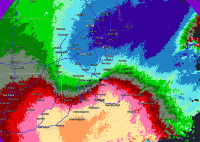
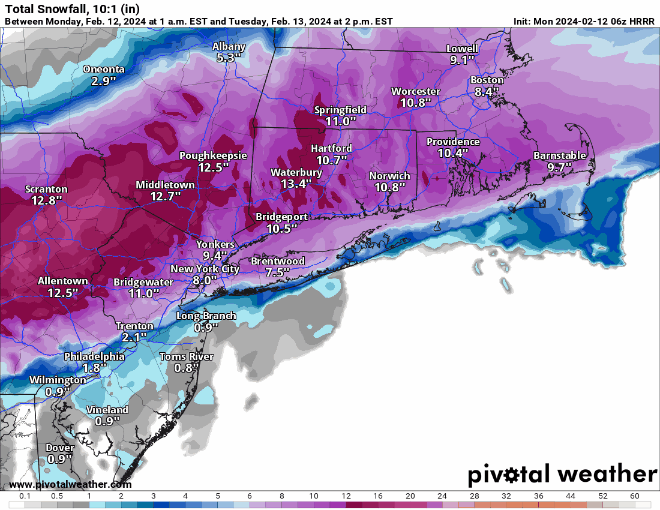
Not really wanting winter weather anymore, but you have to admit, this is impressive:

-
6
-
-
1 hour ago, HoarfrostHubb said:
Beer. If I bring home a lot of grading, I will have school... If I leave it here, it will be cancelled...
Sounds about right...so bring it home. We really don't need school cancelling / power outage level snow in April.
-
1
-
-
Ice pellets here in central MA, around 800' elevation.
-
2
-
-
47 minutes ago, WinterWolf said:
Lol…that’s what ya get in April when big snow hits. We’d be glad to take it off your hands, but unfortunately it doesn’t work like that.
Yikes, don't send it this way. The .25 inches of ice we got a week ago did enough damage here...
-
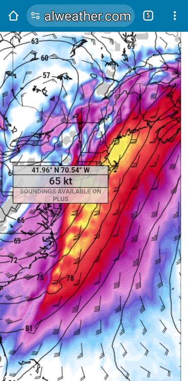
1 hour ago, AstronomyEnjoyer said:
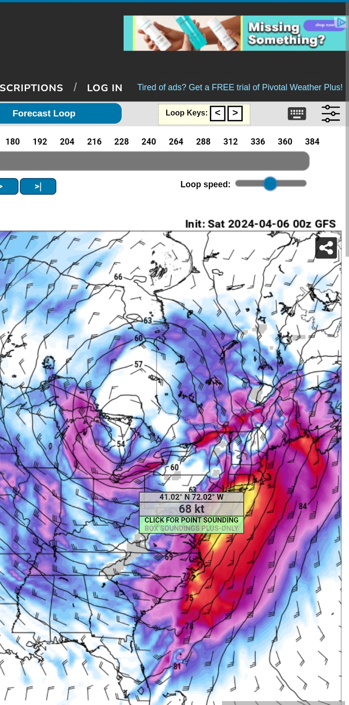
These are the kind of numbers you like to see on your point and click.
Maybe in January or February? The garden is calling....I'm about ready for 60F with sun for a several day stretch now.
-
Waking up to a little fresh powder in central MA this morning.
-
1
-
-
2 minutes ago, HoarfrostHubb said:
Cloudy out here in N ORH county
I'm right at the border of N and S ORH county, and we have a dusting of snow so far.
-
1
-
-
2 minutes ago, Sey-Mour Snow said:
Meso issued for shore 1-2+ for several hours
24 hours ago folks were talking about how NYC kids were going to have a remote learning day for nothing more than white rain, and now they're in a meso for heavy snow bands.
-
NEAR TERM /UNTIL 6 PM TUESDAY EVENING/... 10 PM Update... The southward trend continues with 00z NAM, HRRR, WRF-ARW and WRF-NMM. Lowered accum north of the MA Pike where confidence is highest in less snowfall. As a result converted some of the warnings to advisories and dropped the advisory for NW MA. May have to lower amounts further south but no changes made along and south of the MA and will await full 00z model suite before making any changes. -
Adding to the epic bust factor…is MA and Boston telling all nonessential state and city employees to stay home tomorrow.
-
7 minutes ago, weatherwiz said:
finally got around to making an updated forecast

If only the slowly deflating balloon sound effect could be added to this….brrrrrffftttttttttttpppphhhhhhphphph
-
 2
2
-
-
7 minutes ago, MuddyWx said:
We'll remember this one for a while
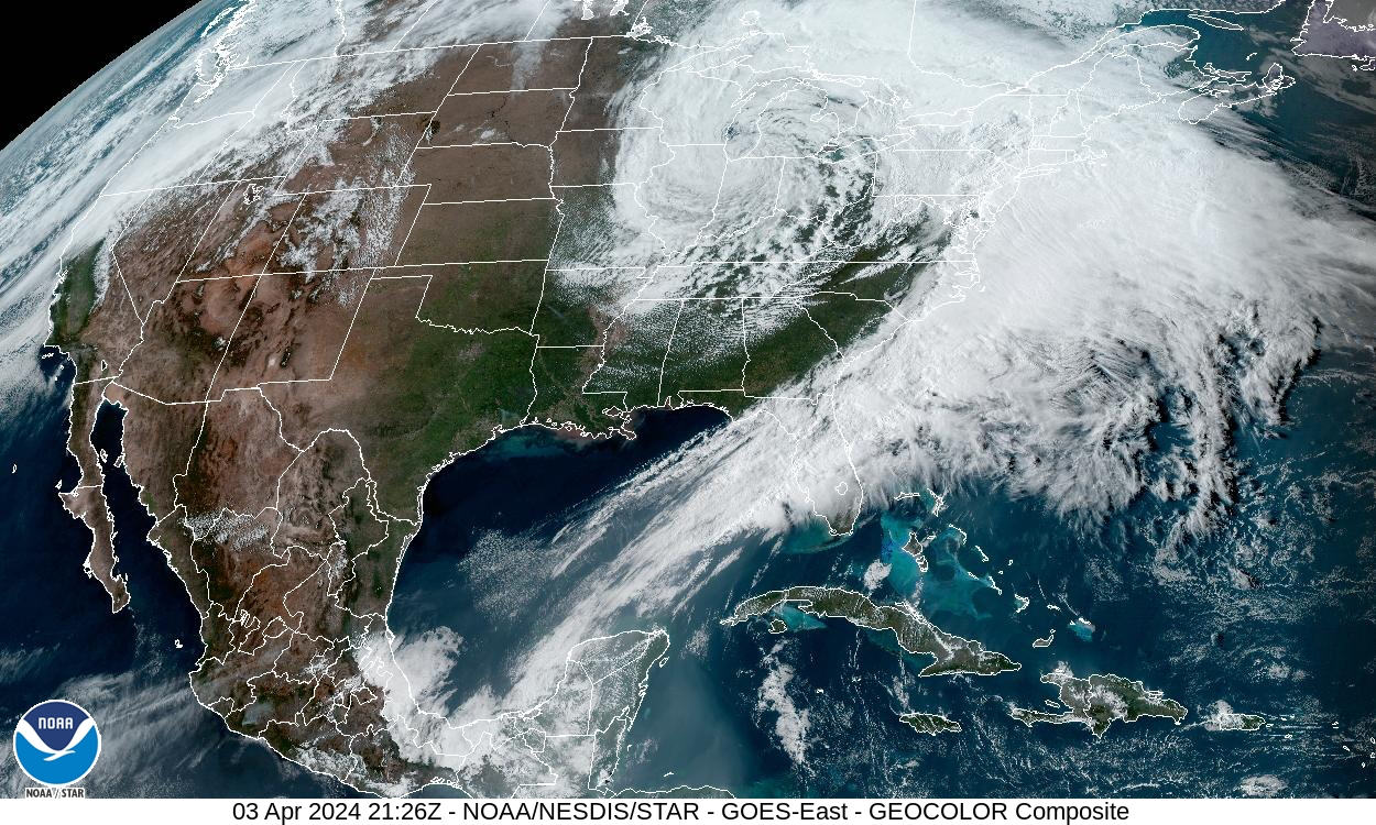
Slow motion train wreck right there.
-
3 minutes ago, HIPPYVALLEY said:
.png.3366f54d9455fecc9a505eeee39bdf01.png)
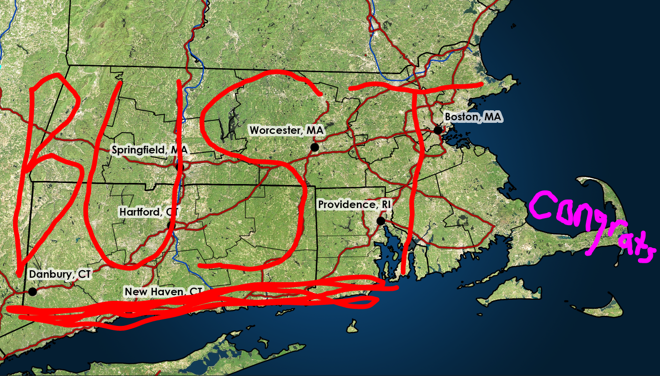
When a picture is worth 1,000 busts.-
1
-
1
-
-
The model shifts are surprising on their own. What seems even more surprising is how confident NWS was in their forecast prior to the shift. This was not a low confidence forecast late morning today.
-
3
-
-
6 minutes ago, Spaizzo said:
Our schools here cancelled right before the models ran south. It’s better for working parents to be able to plan childcare if needed.
.Ours closed 2 hours AFTER. Go figure...
-
1
-
-
Just now, ChangeofSeasonsWX said:
Do you think at this point we can unanimously agree that this storm constitutes the biggest winter storm bust of the 21st century?
Why does bust seem like such an understatement for what happened today?
-
1
-
-
2 minutes ago, Sey-Mour Snow said:
has anyone else seen a bunch of large flys the past two days? I've had three in two different indoor locations? The low 60s Saturday woke them up?
I heard one on the back porch today. Didn't see it, but I know it was there.
-
Fairly brutal BOX update...since I didn't see it posted here
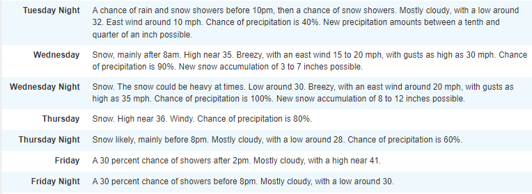
Well, I`ll get right to the point with this update, there`s been a
big change to the forecast this afternoon based on a remarkably late
but notable trend in the 12z/18z guidance which now keeps the bulk
of the snow centered over the south coast of southern New England.
This change is due not only to a southern shift in the track of the
low but also a notable shift in the 500 mb trough; with a slower and
less amplified solution and the northern and southern stream energy
failing to phase/strengthen as they pass through the region. This
shift has notably moved the zone of mid level frontogenesis to the
south, and since we typically see the best forcing/banding to the
northwest of the maxima this places southeast MA/Cape Cod and
southern RI in the bullseye. BUFKIT soundings do indicate decent
omega (forcing for lift) within the dendritic snow growth zone
further north into MA, so we should still see some decent snowfall
there, but the maxima looks to be south and east. While this is
remarkably late in the game for such a relatively big shift, nearly
all of the 12Z guidance including the 12Z ECMWF, 18Z NAM, 18Z HRRR
and more show it. The new forecast calls for a swath of 6 to 10
inches across southeast MA/RI with a pretty tight gradient to the
north down to potentially nothing in far northwest MA. Uncertainty
remains high, however, given marginal temperatures at onset (though
good dynamics should help cool the column to overcome this) and
potential for a shift back north with overnight guidance. This
southern shift brings slightly cooler air which may help mitigate
snow loading risk a bit, but a wet, and rather heavy snow continues
to be expected. Blizzard conditions are possible, especially on the
outer Cape where the strongest winds are expected, with gusts has
high as 55 mph possible. Elsewhere winds will be gusty, blowing 30-
40 mph over southeast MA and along the immediate coasts of MA and
RI. The Winter Storm Warning has been expanded into Cape Cod and the
islands while it has been downgraded to a Winter Weather Advisory
for western and north central MA.
-
 1
1
-
-
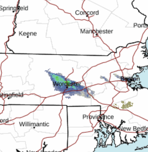
24 minutes ago, HIPPYVALLEY said:
Still decent south of Pike but might be too high still.

Oof. From solidly in the 12-18" in Worcester to this? Part of me wishes I was a fly on the wall when they had to make this call over at NWS. About 12 hours before the storm, no less.
-
1
-
-
Just now, MJO812 said:
Its official
NYC schools are closed tomorrow
Remote Learning
Very weird
I can't imagine they've had many (if any) snow days this year. Why not give the kids a real snow day? Who knows when they'll see it again.
-
3
-

.png.582674ded7fe1d39a20150a3b7d455c3.png)
.png.97c9d278fa046543bd51898411530aea.png)
April 2024 Disco- SNE’s favorite month
in New England
Posted
If this info is correct, 2023 was the 4th wettest on record in Worcester. If we keep up the same rate we've had so far in 2024, we would probably surpass that.
https://www.extremeweatherwatch.com/cities/worcester/year-2023