
Beach Snow
-
Posts
219 -
Joined
-
Last visited
Content Type
Profiles
Blogs
Forums
American Weather
Media Demo
Store
Gallery
Posts posted by Beach Snow
-
-
4 minutes ago, ILMRoss said:
NAM looks better.
I'm used to our set-ups going through a slow degradation as we go through the week. But I gotta say the speed at which we went front praying for a more amplified pattern to looking like a zr event for a lot of us really took me aback.
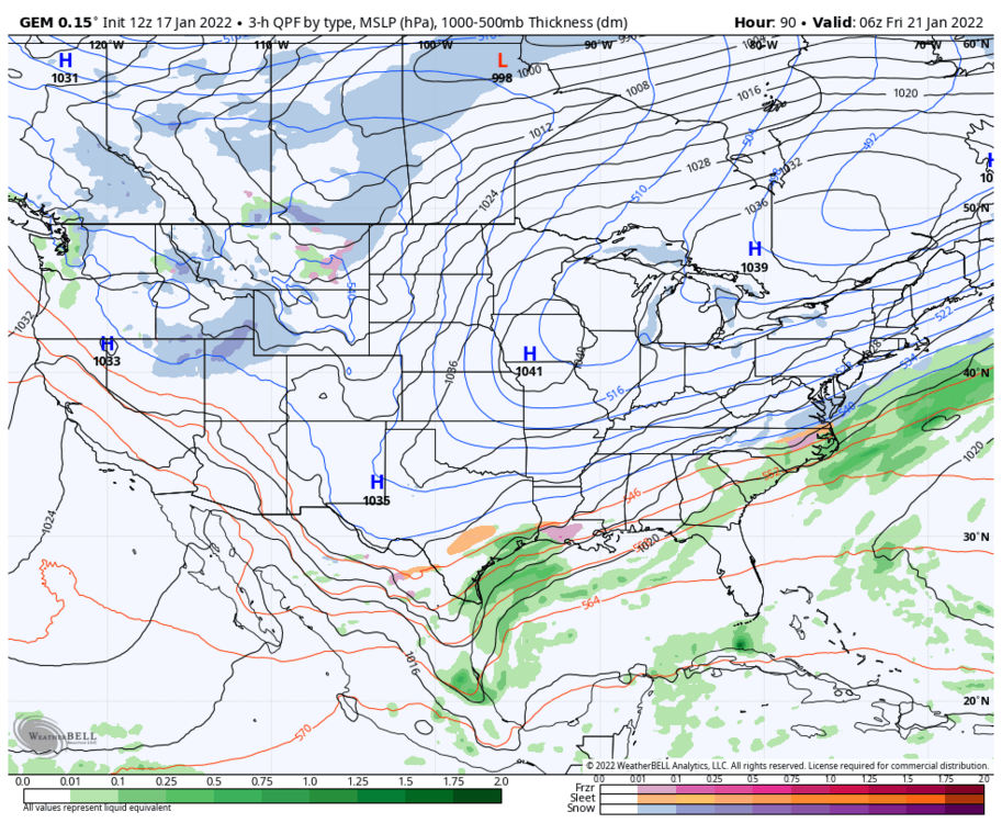
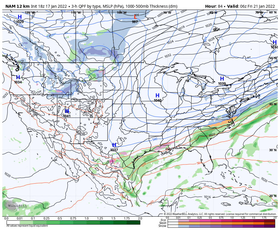
I think that the main culprit is the northern shortwave.. see below for 12 run GFS trend. 3 days ago, that shortwave was diving into the Dakotas with a little oil and vinegar... there's been noise but you'll notice it's gotten weaker and is diving further east. Our current version doesn't dig as far, which is a lose-lose. Not only does it struggle to pop the coastal, but because it is weaker and more retreated into the polar trough, the cold press is weaker, and I think has really allowed for warmer mid levels to sneak back into the picture.
.thumb.gif.5e3b0c5d635e123a3bb319bb2ac56e97.gif)
I don't think over amplification is the key culprit. Sure, looks like it on the Euro, but that's the risk in playing with southern energy as the Euro currently depicts. A stronger northern shortwave in that case would bring a stronger cold press and would likely be able to throw cold water on the southern shortwave's idea of going up the coast.
The NAM had an encouraging jolt westward with our energy. It may be a little late, I think "go time" is sooner than most people realize, but I think there's still some wiggle room to trend to some more positive solutions.
Thank you for the disco! Super helpful for us map readers!!
-
MA guys are probably going nuts. NAM drops 4-8” Thursday night before we even see the weekend storm…sheesh
-
10 minutes ago, Brick Tamland said:
Are we about to get NAM'd?
Can’t tell too much but definitely looks more like euro than GFS
-
 1
1
-
-
2 minutes ago, BornAgain13 said:
Hopefully the 0z GFS caves tonight....
And the euro comes back south and east
-
 1
1
-
 2
2
-
-
4 minutes ago, Grayman said:
Is it still showing the crippling Ice south?
Only goes out to hr 90 for ice and sleet maps
-
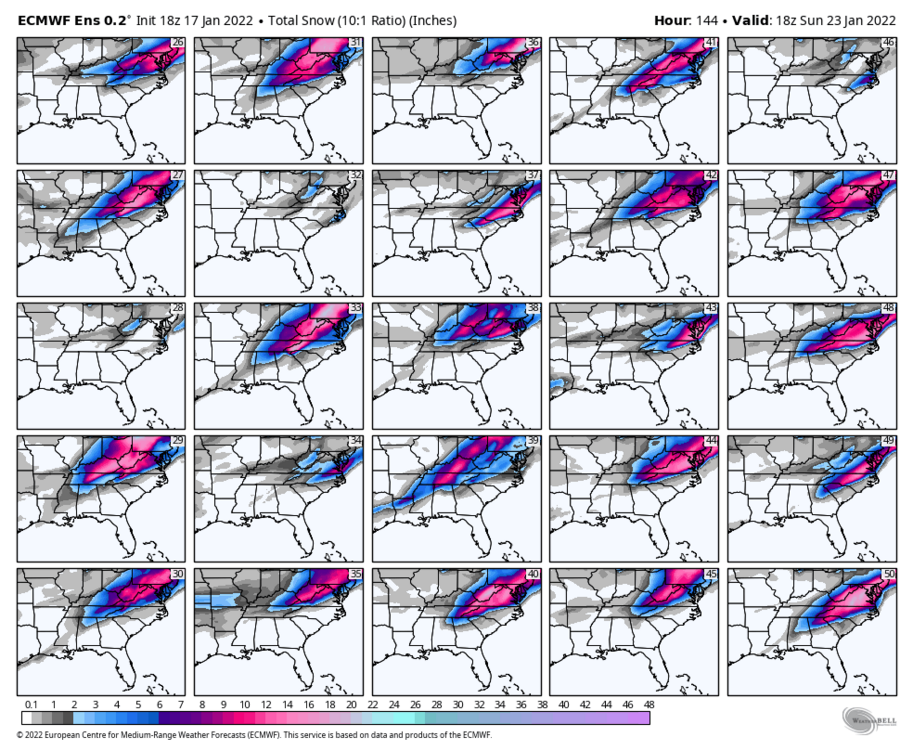
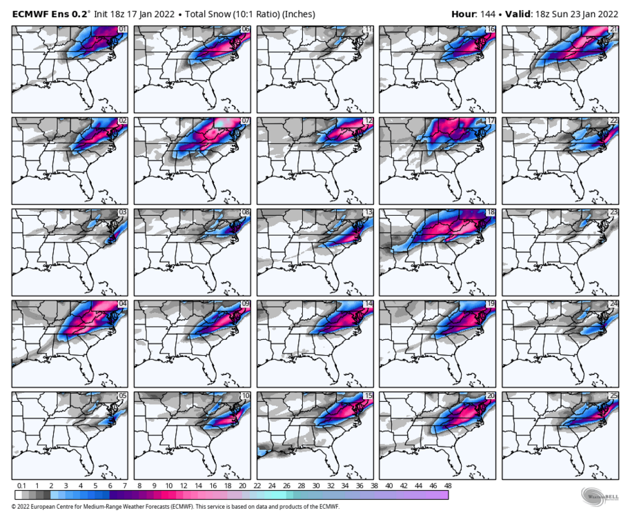
Still 20ish or so members showing a more southern solution…i think the NW solutions are such big hits is why the mean jumped so far NW. maybe i could be reading them wrong.
-
1
-
-
Not good trends at all, really need the Canadian to hold its ground or maybe we see a Euro GFS blend? Really hoping euro is too amped
-
1 minute ago, Brick Tamland said:
What's the saying? Deja vu all over again with this weekend's storm.
Yup, if 18z euro is right that was nail in the coffin…huge shift NW
-
8 minutes ago, tarheelwx said:
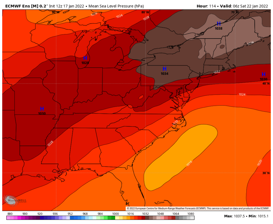
18z Euro looks about the same as the 12z through 90 hours. Seemed to be setting up for a long term event.
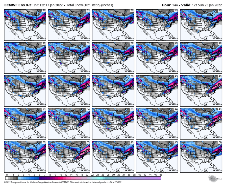
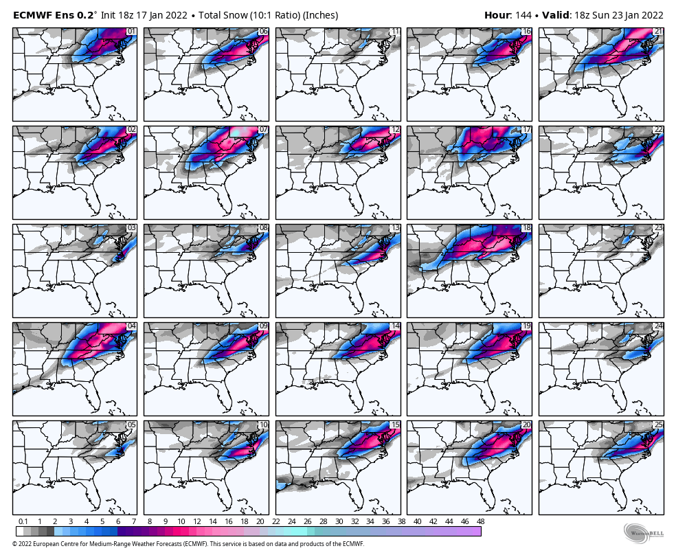
TWI’ll post ensemble snow maps when they roll out
-
 1
1
-
-
18Z GFS second wave for Sunday is SE of 12z
-
18z GFS separating the 2 systems.
-
Just now, BornAgain13 said:
18z ICON is a big hit for southern VA
Yea looks like it shifted access more NW similar to Euro, or maybe just expanded precipitation coverage
-
 1
1
-
-
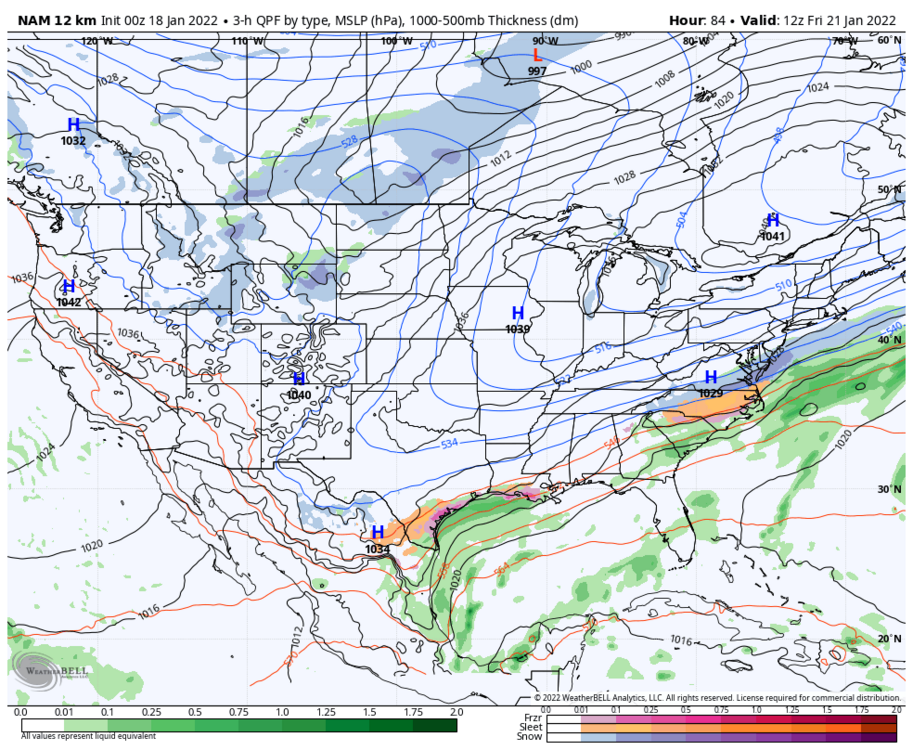
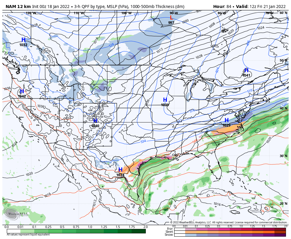
Fwiw the 18z NAM has almost the exact same surface map as the Canadian does at 84hrs….yes yes i know it’s the NAM

-
4 minutes ago, CaryWx said:
It's that pesky 850 track though Beach
Agree, but the further east the low is less likely the 850s creep inland…i think.

-
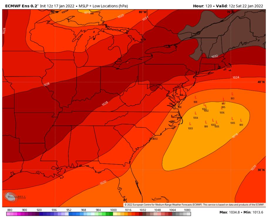
Most LP are well offshore compared to OP
-
1 minute ago, BornAgain13 said:
Who will fold this time... gfs or euro...
I truly believe the CMC is the most likely solution…it seems to be the middle ground.
-
Individual members
-
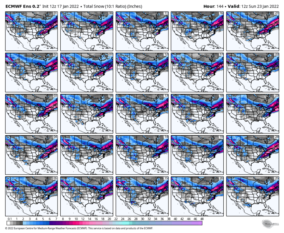
EPS looks great

-
2
-
-
4 minutes ago, Brick Tamland said:
Doesn't seem to matter how the storm evolves, we're seeing the same thing happen on the models with this storm as we saw with the one we just had.
Agree, but we are within 100 hours. With the recent storm there was tons of agreement between most models within this range. This storm has less agreement in closer range which is unfortunate
-
Just now, olafminesaw said:
.thumb.png.7d3beb9d63d6ae28c9754f452dedaf0d.png)
This actually looks reasonable we have GFS Suppressed and euro amped. This looks more like CMC which could be the middle ground. EURO Ensembles will be interesting.
-
Euro amped
-
1
-
2
-
-
1 minute ago, Brick Tamland said:
Sounds like the Euro might be coming in good
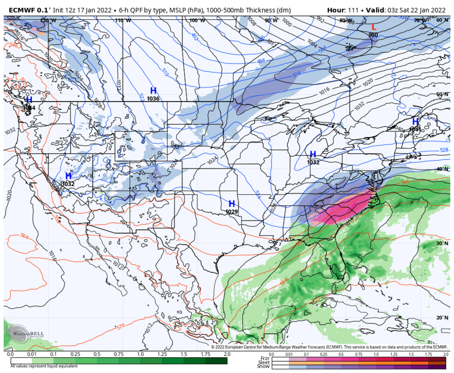
As soon as we get in range ill start posting surface maps
-
4 minutes ago, olafminesaw said:
GEFS does look good for 95 east
-
7 minutes ago, Brick Tamland said:
Greg Fishel's thoughts. He actually likes the GFS over the Euro.
HERE WE GO AGAIN!
No sooner do we get done with one winter tease, and now we appear headed for an encore performance later this week or over the weekend. The operative word here is "tease"! I must say, after singing the praises of the European model for decades, something has gone very wrong with our friends across the pond. Take the last 3 model runs for instance-big snow to nothing to big snow. I actually trust the American global model more now, and I never thought I would utter those words.
Well, no matter what happens with precipitation, another potent shot of arctic air is on the way, and our overall below normal temperture pattern seems destined to continue for awhile. We've experienced below normal temperatures 7 of the last 10 days, with more to come. If anything does happen later this week, it would be induced by the development of a wave of low pressure along the leading edge of the next cold air mass. The question is does that happen, or is it just an innocent cold frontal passage? Time will tell.
Time will tell but we are literally only 4 days and i can’t see how the gfs is right this time when so far 3 including icon of 5 globals show a decent event
.gif.c608dfb56eea2ab695d491a1658629c4.gif)


.png.9ef0f83603d4d90f1e80a446c9c465fe.png)

January 20-22 “bring the mojo” winter storm threat
in Southeastern States
Posted
Icon shows a great storm and actually trended east from 18z a good bit