MPotter_WX
-
Posts
70 -
Joined
-
Last visited
Content Type
Profiles
Blogs
Forums
American Weather
Media Demo
Store
Gallery
Everything posted by MPotter_WX
-
January 31-February 2, 2021 Major Winter Storm Observations
MPotter_WX replied to Ralph Wiggum's topic in Philadelphia Region
7.4” in Hellertown. A tick more than expected this time yesterday. Wife said she heard mixing as early as 530a, so my additional 3” from 1130p had to of been slightly more. Mixing still continues but CC is collapsing. Round 2 coming up! -
January 31-February 2, 2021 Major Winter Storm Observations
MPotter_WX replied to Ralph Wiggum's topic in Philadelphia Region
4.4” in Hellertown as of 1130p. Can only hope we’re in for 12”+ tomorrow -
January 31-February 2, 2021 Major Winter Storm Observations
MPotter_WX replied to Ralph Wiggum's topic in Philadelphia Region
1.8” in Hellertown. Crazy to think we’re more than 12 hours from the main show -
January 31-February 2, 2021 Major Winter Storm Observations
MPotter_WX replied to Ralph Wiggum's topic in Philadelphia Region
0.8” of fluff in Hellertown. Long way to go -
January 31-February 2, 2021 Major Winter Storm Observations
MPotter_WX replied to Ralph Wiggum's topic in Philadelphia Region
Flurries in Hellertown -
3KM NAM looks like trash. Keeps the good stuff in NJ
-
Pretty good consensus on the 6z runs. I’m leaning towards 16-20” here in the LV. However, I’m still wary of these systems as they can pull the rug out from underneath you. Just gonna have to wait and see where the 1”+ per hour band sets up. Here’s hoping to a bust on the high side for everyone!
-
Definitely liking the chances of 12-18” here in the LV. However, if the best forcing/frontogenesis slides east, lots of people (including me), will end up very disappointed. We KNOW someone is getting 24”+ from this storm, but unfortunately, we’re not going to have location until this is in progress.
-
I said I was curious to see what the RGEM would do and it shifted its bullseye right over the LV. STOP THE COUNT!!!
-
Very curious to see how the RGEM portrays this system at 0z. It’s been quite an outlier.
-
I’ve been waiting to say anything on this storm because I didn’t want to jinx anything. Great consistency with the NW jog among the models and now those in the Lehigh Valley may actual hit the 12”+ mark. Mixing is not a question up here, so it’s basically riding on the position of the 1”+ per hr band of snow that sets up Monday. Regardless, this system is too amped and wrapped up at 500 mb to not produce close to 20-24” somewhere in E PA/N-C NJ. It’s almost showtime!
-
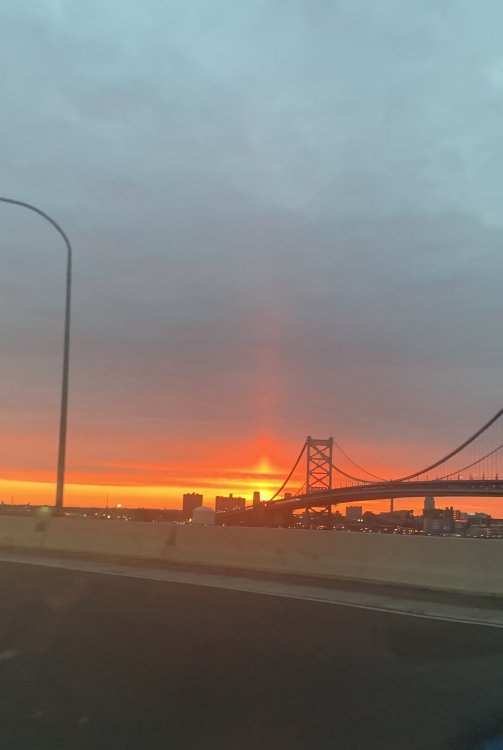
Had a nice sun pillar this AM over the Ben Franklin Bridge!
-
Waking up to a light covering of snow. About 0.1”
-
Some patchy ice on elevated surfaces here. Around 32 based on local obs
-
Light sleet/rain mix in Hellertown. Expected to go over to all rain within the hour
-
Thanks for the input!
-
Oh wow, it’s definitely a pricy item from what I just saw. Doesn’t surprise me though that the higher tag price would yield better results. Is it worth the extra money?
-
Going along with another recent post, I wanted to open this one to cover a broader selection. I’m starting to look at purchasing a home weather station myself and wanted to see if anybody had input. I have seen reviews on the 6250 Vantage Vue, the Tempest weather system, and the Ambient Weather WS-5000/WS-2000. Looking to see who has what and whether these are accurate for rainfall/wind. Any other suggestions would be helpful!
-
Definitely getting excited here in the LV! Looking like at lock of at least 12”+; however, I am a little wary of mixing with sleet should enough warm air filter in aloft if those trends N occur. The strength of the confluence/1038-mb high is a saving grace for this event. The position of the coastal low will ultimately decide the fate of you guys to the south, so keep the faith. As is typical of all of these systems, once we get a good sampling of this system once it makes it to the west coast (12z Monday), we should have a good handling of its position.