
MRVexpat
-
Posts
242 -
Joined
-
Last visited
Content Type
Profiles
Blogs
Forums
American Weather
Media Demo
Store
Gallery
Posts posted by MRVexpat
-
-
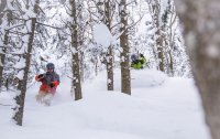
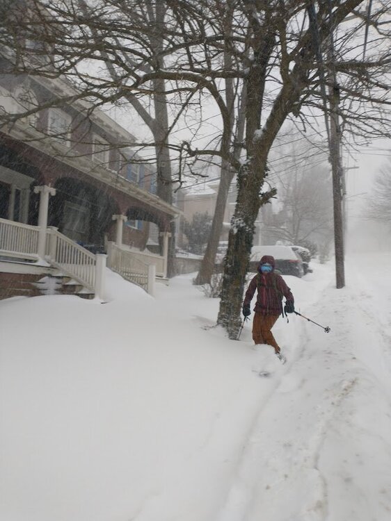
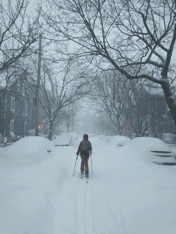
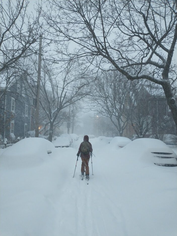
Not sure which thread this belongs in but here are some pics from our excursion to Summit Ave in Brookline!
-
 2
2
-
 1
1
-
-
12 minutes ago, Massplow said:
What is the start and end time look like for accumulating snow in the Boston area. Been busy getting everything ready havnt had much time to follow along
Also curious.
-
Good rates and snow growth at Stratton. Eyeballing at least 10"
-
45 minutes ago, Hitman said:
The groomers don’t do anything to get the heart rate up. That’s the issue. At least if there are moguls the exercise gets blood flowing to the extremities. You finish a groomer and you’re just as cold if not colder as when you started.
Slalom skis being the exception. Pays to have those in your quiver skiing in New England.
-
4 minutes ago, PhineasC said:
I am not totally familiar with the geography up there, but you are facing NW right? This is an east flow event from the coastal but I'm sure when the winds shift you will get buried in fluff with all the residual moisture around and it's not like the low escapes to the east, it goes right over NNE. Should wrap some stuff around I would think.
Yeah the low placement seems nearly ideal, its just that it moves out of the area fairly quickly. I'd like to think those areas (esp Jay and Stowe) are good for a decent topping of fluff after the main event.
-
3 minutes ago, bwt3650 said:
What’s with the snow hole over the northern greens?
Shadowed by the Whites? Idk tho. Over the NEK it makes more sense...
-
Just now, powderfreak said:
I hope you guys are right, that’s how we get more snow up here too if that thing tugs SE.

What's your thought on ratios assuming CVT/NVT don't get in on that banding?
-
21 minutes ago, wxmanmitch said:
20° F and overcast. I think I see a tiny little under the radar snowflake from time to time too.
I had a minimum temperature of -7° F yesterday, which was the coldest since last winter. I had a cheap midnight high of 7° F though since the arctic boundary didn't reach my location until around 2 AM. The daytime high was -3° F despite full sunshine.
I had 3.4" of lake effect snow with 0.2" LE Sunday night through Monday night. Total snow depth is 6". While it's not much, it's a full on Currier and Ives winter scene out there with snow and ice on the trees. So much better than that garbage pattern we had December into the first week of this month with rain, freezing rain, fog, and mud.
Saturday's arctic shot is the real deal, and I fully expect double digit negatives here Saturday AM for the first time since MLK Day 2019. It doesn't look like there will be a cheap above zero midnight highs either as this boundary comes in late Friday.
The Sunday night and Monday storm appears be our first significant synoptic snowstorm. While it may take a track over or west of us, the storm could occlude off to the SW of us, which in essence cuts off the warm air from the low center. Although a track like this would usually be the kiss of death, not this time. Worse case scenario it could be a good front end dump followed by a dryslot with some light snow or mix. Also, an occluded storm to the SW of us could result in a nice firehouse LLJ from the E or ESE, plastering the Greens and their eastern slope with a solid 12"+ storm while the western slopes get shadowed with strong downslope winds.
All of this assumes and early capture by the 500 mb low as much of the guidance currently depicts, but if that doesn't happen, the storm will probably take a more traditional coastal storm track along or just off of the shoreline. This could put us in the midlevel deformation zone with a storm that hopefully doesn't occlude as fast. Either way, there's finally some legit hope for us snow lovers in what has been a lean winter so far in NNE.
Sure friggin hope so! Out of curiosity, what is your snowfall YTD? Friends of ours just got a place nearby.
-
3 minutes ago, HIPPYVALLEY said:
I dunno’ I am with @Ginx snewx on this one, I think a track over Boston is more likely than a track over Albany.
Would be huge for the ski areas. Its been such a rough season up there so far.
-
1
-
-
Decent upslope signal Thursday > Friday on the GFS? Just a weak low hanging out in southern QC for some time.
-
1
-
-
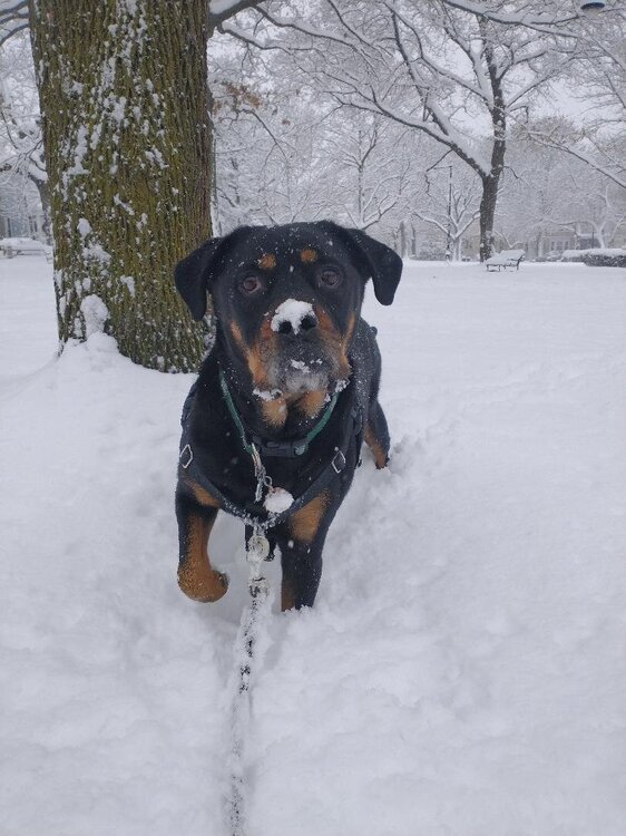
9 minutes ago, HIPPYVALLEY said:
What park is that? Cambridge doesn’t have many open spaces.
Hastings Square in Cambridgeport
-
1
-
-
Just shy of 10" in Cambridgeport after some compaction. This is for sure beautiful, but would rather have it up in ski country. Gonna be depressing driving to a nearly snowless Sugarbush tonight. At least the powderhound loves it!
-
8
-
-
10 minutes ago, psuhoffman said:
No that makes sense for 2 reasons. The ridge sugarbush is on runs more N-S opposed to SW-NE and a NW wind is down sloping off the high peaks region of the Adirondacks. So a W wind would be more favorable.
Looks like the high peaks are actually more due west of the Monroe skyline, so I would think a NW wind would actually avoid downsloping? In my experience a WNW wind is actually best on account of that N-S orientation you mentioned, depending on Froude #s.
But yes, lots of moving parts to figure out something like that. In a classic NW flow setup with a froude around 1, it seems like Stowe generally does 50-100% better than SB. Definitely event dependent though.
-
Up in the NEK. Skinned up Burke yesterday and things looked and skied decently well! Natural trails looked like they could even be carefully navigated up high. First time making turns on this hill and shocked at the minimal crowds this time of year.
Otherwise it's definitely a wintry look around here. 6-8" pack when we got here a few days ago has condensed a little bit.
-
20 minutes ago, LaGrangewx said:
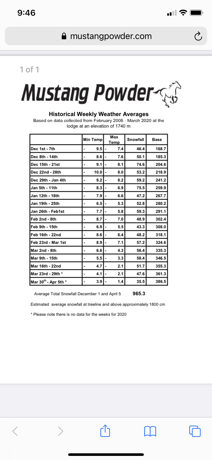
Was snooping around some cat skiing operations in BC after seeing a bunch of Instagram videos recently and found some cool data. Mustang Powder in the Monashee mountains near Revelstoke has kept records at their lodge at 5700’. They claim to average 380” just December thru March which blew my mind. Nearby Mount Copeland had a station at 6000’ for a few years in the early 1970s and averaged like 750” during the 5 or so years and had one year with almost 1000” snow.
Another station nearby in the Selkirks with longer term data Mount Fidelity at 6150’ averages ~550 inches and around 350” December to March. Rogers pass below at 4300’ averages around 350” for the entire season. So the Mustang powder lodge probably averages somewhere around 550-600” during a full winter. Mountains in this region get up over 9000’ so the claims of 800-1000” average snowfall in the higher alpine are probably not far fetched at all.
The Columbia Mountain region fascinates me and is tops on my bucket list of destinations. I have read people claim this region averages the most “dry powder” in the world and they always seem to be consistent, it’s not usually feast or famine like the Sierra can be. The amount of quality powder snowfall in this region blows my mind and truly has to be one of the best regions in the world for snowfall and skiing. Hopefully I’ll experience it firsthand one day!
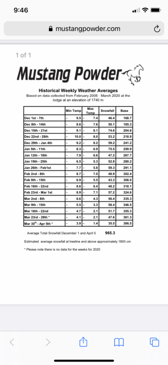
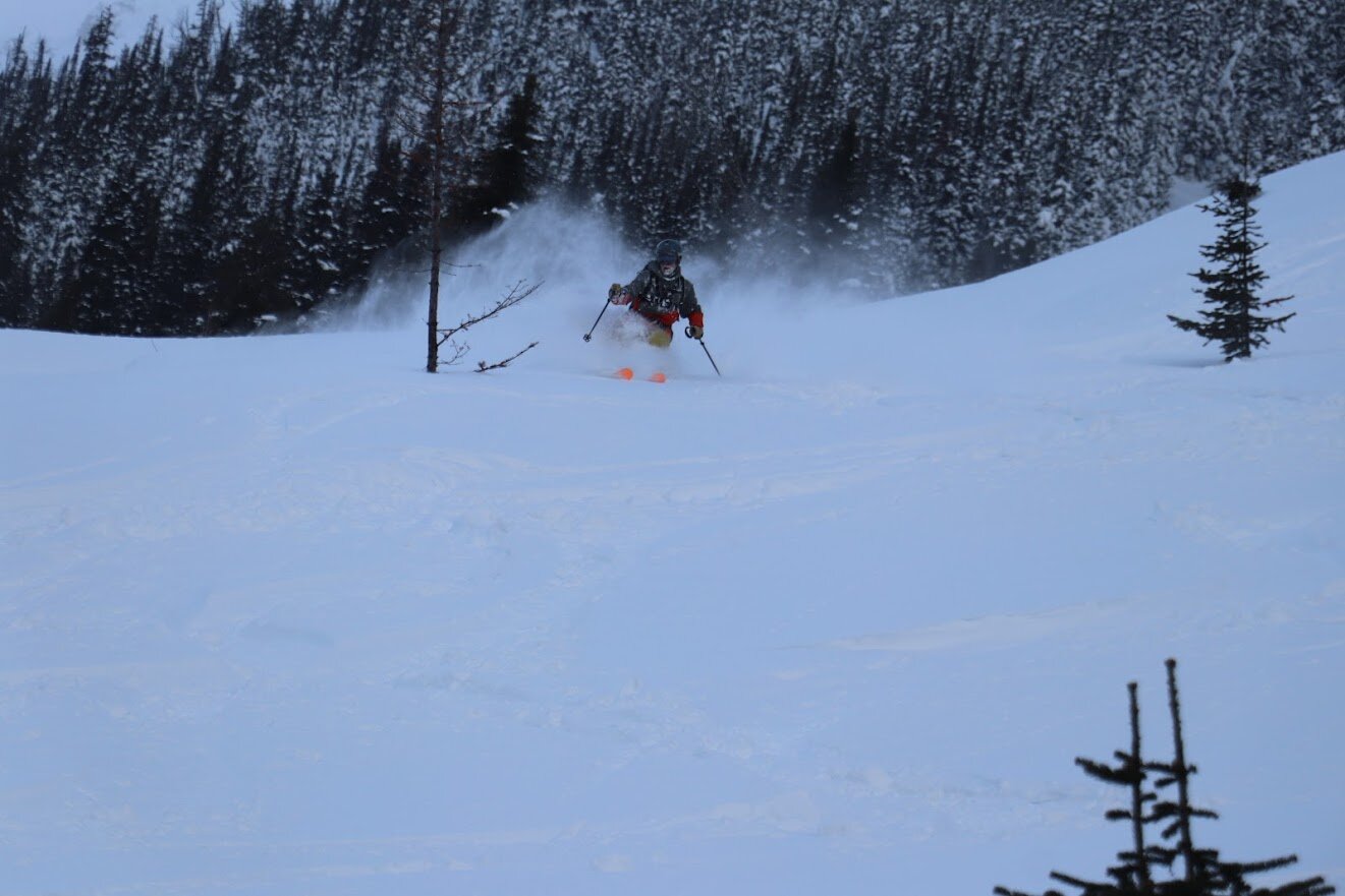
Had a chance to tour in Rogers Pass right before the world went into lockdown. Got up into the 6,000 elevation on Mount Tupper. Could definitely see 500" at that elevation. Pack was deep!
-
2
-
-
3 hours ago, LongBeachSurfFreak said:
Absolutely no shot K has 61 and Okemo 21 when they are only about 30 miles apart and in a very similar geographical area with similar weather. The reality is probably something like 40 and 30. I’ve noticed at Stratton the last 2 winters snow measuring has been conservative to almost under measuring.
Yeah, I feel like this gets discussed at the start of every season. Chalk it up to a marketing ploy with the goal of capitalizing on that early season demand?
I know we've also debated their seasonal snowfall #s as not lining up with others in the area.
-
1 hour ago, snowgeek said:
I was going to go to Stratton on Saturday, but now I'm thinking Sunday might be better as a decent amount of the snow looks to arrive after lifts close on Sat. Thoughts?
Definitely looks like Sunday will be the day. Especially if this prompts any additional trail openings.
-
4 hours ago, bwt3650 said:
Obviously, I have a biased toward jay, but gotta respect how up front they are about the weekend. Winds should be kickin up there Saturday.
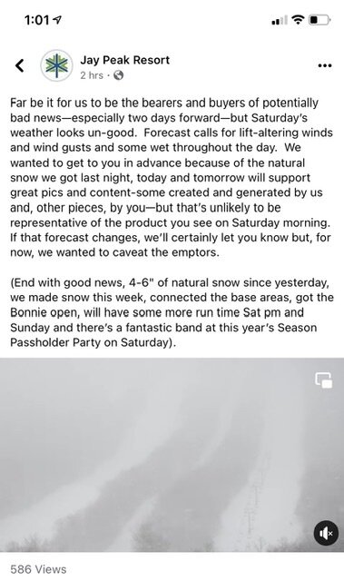
Looks like they're progged to not be too bad until the overnight hours Saturday and into Sunday AM? Have a free place to stay at Killington so am debating the drive up. Saturday should at least be soft...
EDIT: sorry, I realize this probably belongs in the ski thread. also I was looking at the wrong graphic...definitely seems windy.
-
4 hours ago, powderfreak said:
That's not that short on vertical, ha. The funny thing about the vertical discussion, is how the East actually has some better vertical per lift ride than many of the major ski areas out west. Of course there are the Jackson Holes, Big Sky, Steamboat, Telluride, etc but many lifts out west are largely in the 800-1,500 vertical foot length. Even the big vertical mountains, it takes multiple lift rides to get that vertical.
It's one of those things where you go out west and it is hard to find single lifts that do 2,000+ verts in one shot. Of course there's like Snowbird and Jackson Hole trams but it's surprising how the east coast verts compare to out west. There's a lot of yo-yo type setups of 1,000 verts per pod in like Utah and Tahoe.
There's also the effect of spreading out skiers by ability a little bit. Expert skiers can stay on the upper mountain lifts and not ski the often flatter run outs, thus yielding more quality vert per time on chair. Beginners can have their own trail pod. Works out well.
-
19 minutes ago, Ginx snewx said:
Nah you can rip thru Kansas on Jordan and high speed it all the way to little White cap lift. Done it a hundred times literally, 2 plus miles. North Peak 1500 feet high speed is my jam for short vert and having a ball
Yeah I've literally only done it once, on a spring day with inadequately waxed skis and plenty of crowds at the Barker base, hence the need for skate skiing on my part. What you're saying makes complete sense tho, just not the same 2300ish fall line vert at places like Stowe, SB the Loaf etc.
-
13 minutes ago, tamarack said:
Looks right for SR but one needs 2-3 lifts to get there. Top single lift gain looks ~1500' on Google Earth'.
Technically it can be linked by taking a green from OZ to the base of White Cap but there's some skate skiing involved and so definitely not 2300' of fall line vert lol. Having said that, if you can't have fun with an old slow double and 1000', you're doing it wrong. Outpost double at Pico is a prime example (may be closer to 500' than 1000' tho)
-
1
-
-
4 minutes ago, PowderBeard said:
WOW, that is rough. Basically the same vert as skiing Sunday River.
Just noticed Sugarbush got Ripcord and Spillsville open. I'm feeling a quick trip up.
Per reports it is fun but damn thin. No surprise given the liberal trail opening policy there.
-
2
-
-
1 minute ago, GCWarrior said:
Just leaving Stratton. Whatever they got blew around everywhere. I’m sure killington is the same way.
It's pretty good for opening day, but the snow surfaces are definitely inconsistent. Still fun to get the legs back.
-
1
-
-
1 hour ago, Sugarloaf1989 said:
Killington reporting 19" of snow in the last 24 hours. That's the most I've seen.
Always take with grain of salt
-
1
-


NNE Cold Season Thread 2021/2022
in New England
Posted
BTV AFD mentioning 8-10:1 to start followed by 12-15:1 beginning Thursday night. Right side up! A skier's delight. With most models showing 1.2-1.6 QPF thru C/NVT, this should be that solid pack injection that J Spin has been talking about.