
jlh
-
Posts
144 -
Joined
-
Last visited
Content Type
Profiles
Blogs
Forums
American Weather
Media Demo
Store
Gallery
Posts posted by jlh
-
-
6 minutes ago, NorthHillsWx said:
The NAM is a joke
Yeah, I have less and less been a fan of it of late. But the information passed the other day about it not receiving any more development since 2017 explains it.
-
4 minutes ago, VARTV said:
Yikes... they did... 2-3" for the immediate Hampton Roads area...
Yup. Seems surface temperatures are going to have a hard time getting down the freezing until near sunrise Saturday morning (back side)so while we might get a lot of snow in the sky, unless its convective/heavy it isn't going to last long on the ground. Makes a lot of sense though, often the story with nor'easters in our area.
-
 1
1
-
-
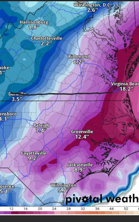
Seems as though AKQ is going with the idea of less accumulation even in coastal NE NC. Afternoon update has most of the snow falling just above freezing except for a few hour span. Cut back from 3-6" to less than 2". Hopefully we can snag a bigger window at freezing than they are thinking but that onshore NE flow, makes a lot of sense why the temps were bumped up.
-
2 minutes ago, Sandstorm94 said:
GFS has been the first to pick up hits, it is not to be taken lightly this winter...
Sent from my SM-S115DL using Tapatalk
Definitely been a good sniffer at range.
-
Posting this to whoever drops in later on... I have had awesome results with my Acurite Atlas 7 in 1.
-
On 11/6/2021 at 2:08 PM, SHW said:
Hi folks.
I need some help.
Does anyone know of a visual interior screen display that receives (and displays) current weather data for my area?I don’t really need a station that gathers data from an instrument that I set outside.
I need a display that gets data from the NWS (or other service) and displays it on an LCD screen.
Can anyone help?Thank you!
There used to be one made by a company called BIOS that would do that, do not know if they are still around though. Nearly everything these days that has a screen and shows local forecasts still utilizes at least a temperature sensor in your backyard.
-
2 minutes ago, WinterWxLuvr said:
We don’t know. For me the range is nothing to perhaps as much as 3-4. That’s not knowing.
Yeah, a low is going to be out there, that is about all i'm on board with. Guidance has shifted from perhaps 1" to over 12+" in my backyard the last few days. Just waiting for tomorrow evening to get here so I can gaze at a radar and out of my window.
-
1 minute ago, WXNewton said:
For what is worth the 6z HRRR showed a very similar setup as Euro with rotating a band of moisture through the Foothills and NW Piedmont into Upstate SC. It too is trying to pop a low under the foot of the mountains. I know it's the HRRR at long range but definitely something to keep an eye on for folks around 77 and 85 corridor.

RGEM depicts FGEN banding in that same area.
-
2
-
-
10 minutes ago, olafminesaw said:
RGEM is the RDPS (confusing I know)
Really now? I figured they were different because tropical tidbits had them listed separately lol. Thanks for letting me know! I see RDPS is listed as the GEM's pilot model. Makes sense now.
-
22 minutes ago, Brick Tamland said:
RDPS looked good, too. Seems like it's a battle of the short range vs the globals. The GFS does look better than the Euro for here, though.

Very similar to the RGEM, perhaps ever so slightly further west.
-
6 minutes ago, LP08 said:
Even has Euro soundings too!
That's really awesome, super happy about that.
-
1 hour ago, Ji said:
When did tropicaltidbits.com get ecwmf precip. That's huge
Must have been this week, it wasn't there for the last storm.
-
AKQ issued Watch for the coastal plain, calling for 3-6". Forecast discussion noted they were going with the Euro as the middle ground between the GFS and NAM.
-
1
-
-
5 minutes ago, BornAgain13 said:
From my house to the east... wow what an increase...
Sent from my SM-N981U using Tapatalk
Such a nice thought, have a feeling Mr. GFS is going to have something to say about all of that. I can't recall when the most recent 12+ inch dump happened in NE NC but from what I've seen here I suppose it was the 80s.
-
NAM is playing with my emotions

-
2 minutes ago, VABILLUPS1 said:
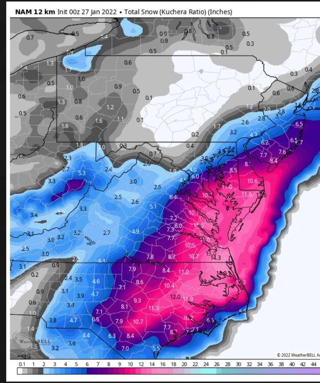
Three words for old-timer snow fans in SE Virginia- Blizzard of ‘80. That’s what the NAM is showing. The downside? It’s the NAM. Real interested to see what the RGEM shows tonight. If that jumps on board we may have something historic here.
Was that the same as the Circus Blizzard or was that later in the 80s?
-
3 minutes ago, BornAgain13 said:
Wow
Sent from my SM-N981U using Tapatalk
Holy moly
-
1 hour ago, yoda said:
The rain? LWX AFD mentioned that could happen at the start
The lack of moisture and the strength of the low with the location of the pressure center. However I noticed on the same run, a few charts down in time it repositions the pressure center with a reading more what I am used to seeing out there with these, and the moisture is there.
-
2 minutes ago, MDsnowPRO said:

YuckNot buying that one bit.
-
5 minutes ago, eyewall said:
The Euro ensemble mean should make the NYC folks feel better. As for NC, well not so much:

Something is something. Will be most interesting to see if a few of these shift back just a tad tomorrow. Seems to be the way it goes.
-
Question for the long term forecasters... Something that is interesting to me is looking at the 18Z GFS at 84. For us coastal NC/NE NC folks, a low center that relatively close to Hatteras usually features a pretty noticeable warm nose that typically keeps us cold rain with the moisture gone before the column sufficiently cools , However, despite somewhat onshore winds at the same time the warm nose in the forecast sounding for the same plot shows only a tiny bump of a warm nose (and still below 0C). My training in weather is more operational than theory and I know the resolution on the GFS is a bit tough along the coast with the influence of the water, however it is unusual that it would depict snow all the way to the bay with where it is depicting this. In the past this onshore influence would normally be depicted and make sense. What would explain the difference this time? I wouldn't think that ocean temperatures would be significantly colder than average, would it? or is the GFS possibly way out to lunch with the lack ocean influence before winds shift more to the NW from NE?
-
1 minute ago, btownheel said:
They are trying to get us a classic Miller A bombshot. Getting closer.
Definitely starting to look that way
-
1 hour ago, olafminesaw said:
RGEM is real close to a solution that work well for most. I think no matter what happens NE NC will fair the best

I'm almost rubbing my eyes in disbelief that we would get two systems delivering snow 7 days apart in this area.
-
7 minutes ago, The Dude said:
Wow. It's been a couple years since I've been on Amtrak. Excited to hear they've upgraded the WiFi experience from Prodigy 1.0 with a 300 baud modem.
Took one from Norfolk to DC not too long ago and was pleasantly surprised with the internet, much better than it used to be.
-
1
-


Potential 1/28-1/30 2022 winter storm
in Southeastern States
Posted
Hampton Roads early Saturday morning.