
jlh
-
Posts
144 -
Joined
-
Last visited
Content Type
Profiles
Blogs
Forums
American Weather
Media Demo
Store
Gallery
Posts posted by jlh
-
-
Central NC, found your problem with getting missed by snow... That pesky heat low will get you every time.
") lol
lol
-
 3
3
-
-
Temp 39.9|Dew 31.1|Wet Bulb 35.1|Wind NNW 4|Overcast.
-
Temp down to 42.3, dewpoint lowered to 30. Wind changed from variable to North-Northeast 5-10mph consistent. Virga overhead.
-
28 minutes ago, chris624wx said:
Not sure if it means much but AKQ had Norfolk getting into the mid 40s today for a high. We've been in the upper 30s/low 40s all day so far.
They progged us to get up to 50 but it didn't happen here either, capped at 45ish and down to 42 now. Hoping we might get down to wet bulb sooner as a result.
-
 2
2
-
-
4 minutes ago, NorthHillsWx said:
As I typed that we seemed to have maxed out. 46.8 was our high now back down to 46.4 hopefully with the cloud deck built in now that’s as high as we will get for the day
Almost 3pm, I am willing to bet that will be it. Hoping the fact that we stayed several degrees cooler than progged today will get is down to the sweet spot sooner tonight.
-
2 hours ago, NorthHillsWx said:
Starting in the upper 40’s-50 never works very well. Just throwing that out there. Hoped we can keep the temps muted a bit
Interesting tidbit, not sure how you faired with your max temp today however, we were progged to get up to 49-50 this afternoon but the cloud deck never gave through and we maxed at 45, has since fallen to 43.
-
10 minutes ago, PantherJustin said:
Is there a massive eye roll emoji? I hope it catches a random Headwind and blast the 7 ppl that live in Halifax Novia Scotia and Boston gets a token dusting
Sounds like a jolly good time to go for a stroll in an automobile.
-
2
-
-
16 minutes ago, NorthHillsWx said:
Radar looks much more excited than the models had it at this point
Wonder how much isn't virga at this point
-
4 minutes ago, NorthHillsWx said:
For a meltdown head over to the NE forum after the Euro run
that's always a fun one
-
1 minute ago, Brick Tamland said:

GFS will giveth 2 feet, then GFS will taketh 1.9 feet.
-
5 minutes ago, NorthHillsWx said:
You literally are on the absolute edge of the main event in Moyock. Literally could be 0 or 6” tonight. Hoping you cash in on some banding with the coastal
Thanks! I was thinking about those accums too, really is a roll of the dice this time. I am hoping surface temps drop a little faster than what the some of the models are hinting at otherwise I will be having a good time watching it convert to water on the ground. I'll take some good banding though, will put a little more on the ground regardless.
-
6 minutes ago, Dunkman said:
It would make a lot more of a difference for them than us I think.
Definitely, with the exception of the edge of the main show in NE and E NC.
-
1 minute ago, Sandstorm94 said:
Might get a slightly earlier phase...
Sent from my SM-S115DL using Tapatalk
Something that was discussed at one of the mid-atlantic NWS offices this morning. Can't remember if it was AKQ or further north but they mentioned the dynamics playing to an earlier phase.
-
Started with a morning low of 26. Current at 43 and rising, dew point 31, overcast with light and variable wind.
METAR HOME 281613Z 10002KT 10SM OVC120 06/M01 A2981
 for my aviation folks...
-
2 minutes ago, PantherJustin said:
Granted it doesn’t have our death band for tonight …. But GFS sniffed another one pretty well day 8-10

NWS has our window of snowfall from 12am to 7am with point and click graph having us above freezing until 6am lol. Explains why our expected accumulation dropped last night. Most likely a product of the low closer to the coast. Will be interesting to see how these other sniffs play out.
-
1
-
-
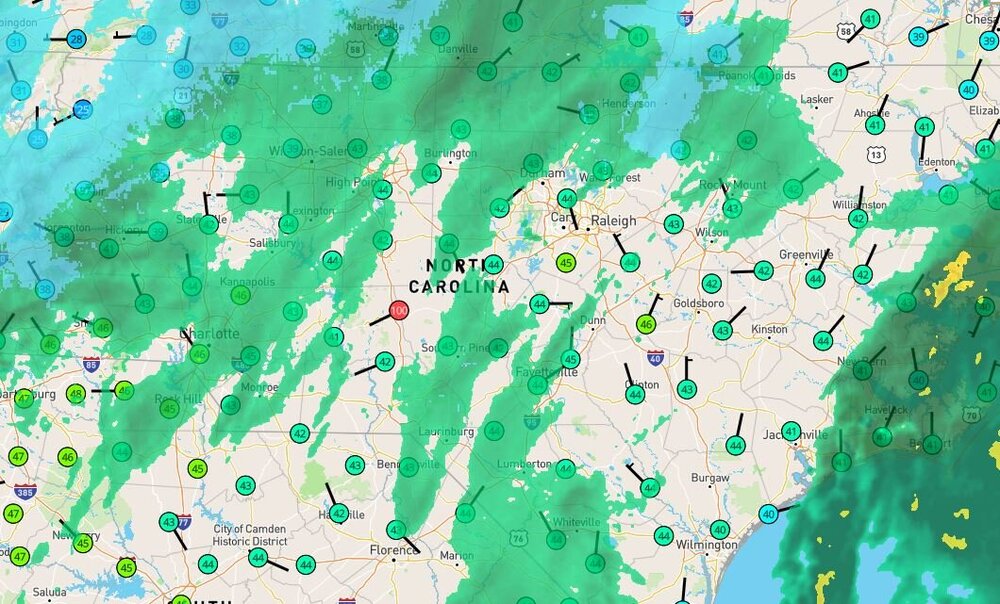
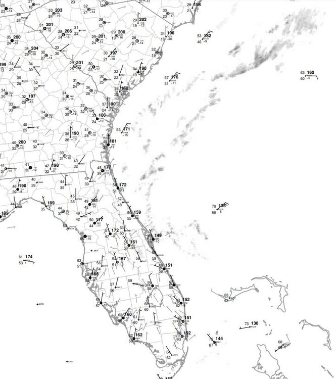
Surface low evident just north of the Bahamas and near Canaveral on the 10Z station plots. Strap in lads and ladies, game on.
-
WSW extended south into Hampton Roads and Currituck, NC. Blizzard warning for Northampton Co. VA, just north of Hampton Roads. Guess AKQ is biting on the slightly higher totals/rates of the higher res models. Discussion not out yet to see which model was verified. Too early for me to dig into it lol.
-
1
-
-
14 minutes ago, chris624wx said:
00z HRRR is a hot mess for NE NC/SE VA...
Seems as though my morning coffee run is going to be good to go. Cloudy with a chance of wind lolol.
-
12 minutes ago, Tigerchick224 said:
Question…is the leeside event some models are showing different from the mesolow forming? I am just learning and curious. Thanks!
.Upslope flow from the NE, called orographic lift. Causes moisture to lift against the mountains and condense, forming precip. That is a separate event from the discussed mesolow, but the presence of it can help the upslope if it's in the right position.
-
1
-
-
5 minutes ago, NorthHillsWx said:
Too bad all the fun in the Carolina’s is coming at night. Definitely serious now-casting. Some people going to wake up with bare dirt and scream “bust” while others 20 miles away have 4” will be screaming “overperformer.” I think it’s boom or bust, light rates are not going to cut it with borderline BL temps like they did last week and if you get fringed by one of those bands you’re not going to get much or anything. Think summertime thunderstorms if you want to know how this will play out
Just your average popcorn variety snow. lol
-
2
-
-
1 minute ago, chris624wx said:
18z HRDPS still brings some good snow into Hampton Roads, but the margin for error is razor thin.

Very close to the depicted good stuff, will be most interesting to see how the dynamics set up for precip field.
-
39 minutes ago, chris624wx said:
Yep. Wakefield just put out new snowfall graphic cutting back totals for Hampton Roads....

.Definitely more believable honestly, I know Hampton Roads has had a few really good nor'easters in decades past where there was double digit numbers, but frankly that's uncommon. Was nice to see some of the models 12"+ a few days ago but realistically that's hard to get where we are.
-
20 minutes ago, VARTV said:
Virginia Beach:
Weather Service - 3"
Channel 13 - 3-6"
Channel 10 - 6"+Willing to bet the TV folks will be adjusting this evening for the news.
-
2 minutes ago, chris624wx said:
12km NAM is down near freezing at 9z so it's just a matter of how this thing develops. You get those heavier rates and you're golden.
May not matter a whole lot if that dry slot sets up over us. It's all good though, i'll take whatever. Last weekend kind of made the season for us lol.

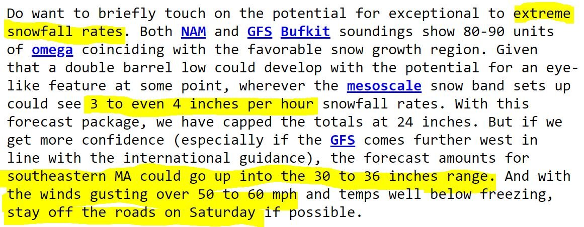
Potential 1/28-1/30 2022 winter storm
in Southeastern States
Posted
Not with the ridge directly north near the Canadian/NY border, it will follow the jet to the NNE until it occludes in New England.