

Danny8
-
Posts
26 -
Joined
-
Last visited
Content Type
Profiles
Blogs
Forums
American Weather
Media Demo
Store
Gallery
Posts posted by Danny8
-
-
1 hour ago, wishforsnow said:
It feels like early April here. Dirty snow banks everywhere. My roof is completely melted off. The animals are acting like it is April. Wonder If the snow statues will hold up for MTU winter carnival. Snowmobiling is on hold. The trails are nothing but rock. There is no base before the big snow early January.
Looking like a good thing I was in the UP mid-January this year. You'll have to give us a snowpack update in 10 days or so
-
2 hours ago, Brian D said:
At the top of that graphic is what I'm expecting in my area. LES event underway right now, especially around Silver Bay to my NE. Radar showing an area of mod/hvy snow right where that bullseye is on the storyboard below. Modelling did a good job this time around.

Interesting! Definitely not the usual lake effect snow location, see it on the northwest shore of the lake
-
 2
2
-
-
18 minutes ago, TheClimateChanger said:
Lowest Minimum temperatures [records in bold]
31F on 5/30 - Third lowest
I think you have the date wrong? ORD was 91/59 on May 30th
-
Can confirm Thundersnow in Irving Park!
-
5
-
-
RECORD EVENT REPORT
NATIONAL WEATHER SERVICE CHICAGO IL
138 AM CDT FRI OCT 27 2023
...RECORD HIGH MINIMUM TEMPERATURE SET AT CHICAGO-OHARE...
A RECORD HIGH MINIMUM TEMPERATURE OF 65 WAS SET AT CHICAGO-OHARE
YESTERDAY. THIS BEATS THE OLD RECORD OF 63 SET IN 1939.
-
20 minutes ago, RCNYILWX said:
I'm off today but according to my coworker, we had to essentially beg the IL EPA to put out an AQA today. They hand out AQAs like candy on 90 degree days for ozone potentially impactful to sensitive groups, but then crickets most of this morning for the worst air quality in years (decades?) here.
And then they put in a dig at us in the 2nd paragraph of the AQA, basically implying that they didn't think they needed to put out a AQA because the air quality is obviously bad and the AQI is available at airnow.gov. Good stuff.
Sent from my SM-G998U using Tapatalk
I was wondering what was going on, Chicago was under Air Quality Alerts all last week and the AQI ended up I think staying below 100 each day. Then today nothing! (Until now)
-
1
-
-
57 minutes ago, beavis1729 said:
- Is it possible to look at some other non-urban locations with long PORs - such as INL or other small cities in WI, MI, IN, IA? Even Rockford IL and any metro suburban areas expereince significant UHI.
 Of course, if UHI is a significant driver of warmth where people actually live, it's bad. I'm just trying to parse out what is UHI driven warming vs. overall "background" Earth warming.
I've been curious about exactly this. The University of Michigan Ann Arbor records go back to 1881 on the NWS site. And University of Illinois at Champaign back to 1888. Would love to know more that haven't moved at all since the 1800s
-
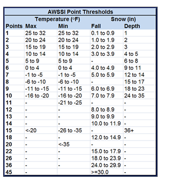
20 hours ago, michsnowfreak said:
Grand Rapids saw one of its snowiest winters on record and hardly any place in Michigan has a big snowfall deficit. In fact southern MI has had some more fierce winter storms than usual. But we don't need cold to get snow. The winter overall was mild and the snow and ice cover less than normal. For individual cities you can go back to 1950 for AWSSI and it's clear that it's an all encompassing formula they use.
Yeah this is how they score the AWSSI for that map: https://mrcc.purdue.edu/research/awssi/AWSSI_InfoSheet_2pg.pdf
-
 1
1
-
-
16 minutes ago, Chicago Storm said:
To show just how thread the needle/dynamic cooling dependent this setup is, it's in the 40's and 50's across Iowa and Missouri currently.

Creating snow via alchemy lol
-
 1
1
-
-
On 1/11/2023 at 11:53 AM, Jackstraw said:
That 200 mile long lake enhanced streamer off of lake Michigan is flabbergasting lol
So is that a lake-enhanced streamer really hitting Indianapolis area now?
-
On 12/24/2022 at 4:47 PM, michsnowfreak said:
@Mimillman, here's the graphic. Wonder when they will release 1991-2020.

1991-2020 is out now. Although the map definitely has some issues, for example Gaylord & Kalkaska normals should have them in the red

-
2
-
-
23 hours ago, Torchageddon said:
The wiki article on the Ontario Derecho had something I disagreed with and has since been removed. The cited source doesn't have anything about this within:
"In Southwestern Ontario, a derecho can be expected about once every two years (once a year for Windsor-Essex), usually developing in the U.S. [[Midwest]]. The [[Kitchener-Waterloo]] and [[greater Toronto]] region experience derechos about once in every four years. Derechos in Ottawa, Montreal, and Quebec City are considerably rarer, but are not unheard of."
It was removed a few days ago since the link below never had anything about Canada in it. I wasn't even sure if there was ever a documented derecho in SON, writing that K-W and Toronto get one every 4 years is ludicrous
 . For Ottawa, Montreal and QC - I'd have to disagree and say they are unheard of
  .
.
If the author comes across this I'd like to hear their side of the story, and if there is evidence of a derecho hitting SON before May 2022.
Looks like two derechos in 1995 hit Ontario. I was in northern Michigan for the one on July 13, 1995
https://www.spc.noaa.gov/misc/AbtDerechos/casepages/jul1995derechopage.htm
-
1
-
-
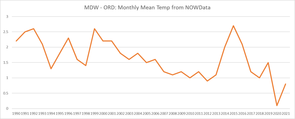
13 hours ago, Hoosier said:
I wonder if it's really cold biased or if it's moreso that it lost the warm bias that it had on daytime highs. Chi Storm would remember better than me but I believe there was a period of time where there was a lot of construction happening around the ob site. I think the ob location also moved to a different location on the airport grounds, so maybe that is a factor?
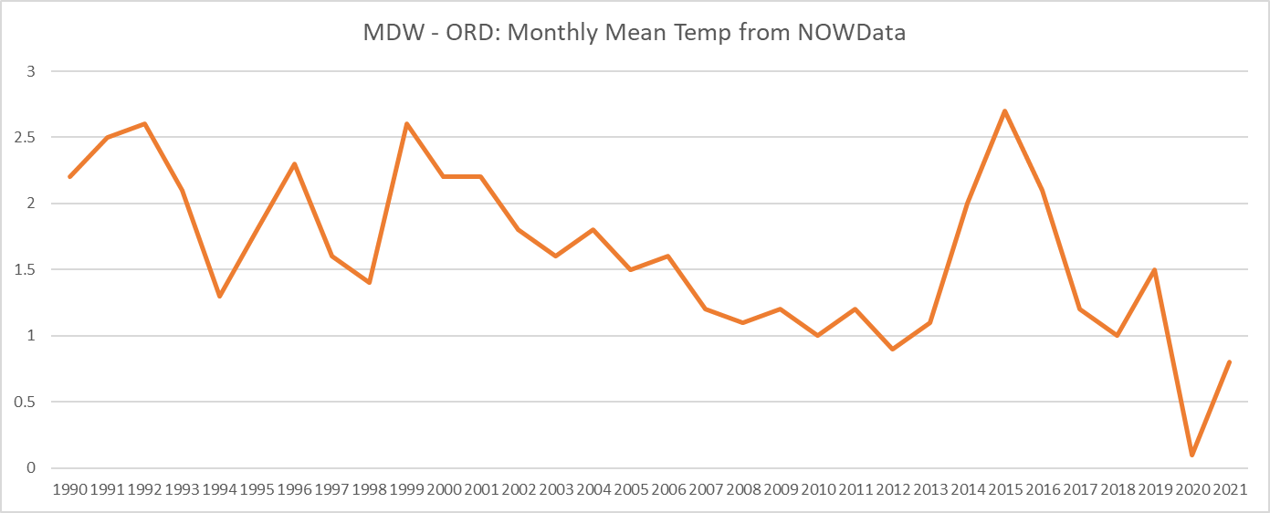
Yeah if you look at MDW vs ORD 2020 was definitely an anomaly where ORD had a warm bias. Compared to MDW at least. I am using the NWS Monthly Summarized NOWData, average temps at MDW vs ORD
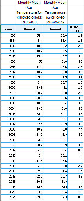
-
The January 28th lake effect snow event put a lot more snow in parts of the city than ORD
-
1 hour ago, Cary67 said:
Xmas will have to be moved to Jan.25th to account for the seasonal shift of winter due to AGW
Ha I agree that it should be moved a month. I want snow all winter but your average citizen only wants it in December for the holidays, so this year was a disaster from that regard.
-
Measured 3.5" at my house in Irving Park.
Lake effect snow coming down fairly heavy at my office in the West Loop right now
-
1
-
-
Has been coming down decently in the north side of Chicago, but slowed for the moment in Irving Park.
It looks on the radar like Metro Detroit is getting some lake bands? Fun to see the NE winds putting lake effect there and up near Green Bay
-
1 hour ago, michsnowfreak said:
I always thought you were around the same age as me (I'm 38). if you want to talk about what we "grew up with" Winters today for the most part are superior to the winters of my middle school & high school days in the 1990s. I was not yet born when the brutal cold of the 1970s masked averages.
Here are Chicago's 30 year DJF normals. As I said, it is 2゚ not 4゚ colder, and as you see 1961-90 sticks out like a sore, cold thumb.
1881-10: 25.7
1891-20: 25.9
1901-30: 26.8
1911-40: 27.9
1921-50: 28.1
1931-60: 28.0
1941-70: 26.8
1951-80: 26.0
1961-90: 25.1
1971-00: 25.9
1981-10: 26.3
1991-20: 27.1Are those all ORD? I thought the early years were right by the lake until MDW became the official site in 1940 maybe. I only bring it up because temps stay warmer by the lake in the early winter
-
4 hours ago, Cary67 said:
A look at seasonal snow averages

I'm hoping the maps update to the 1991-2020 normals soon. Haven't seen it yet for the midwest or nationally
-
Can the pros give some more insight on eclipse viewing conditions? I would also like to head to the Chicago lakefront but it seems like we may be cloudy
-
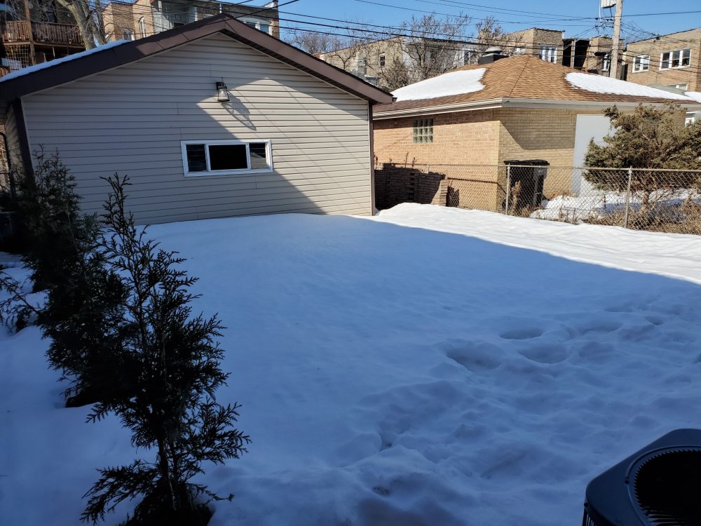
Still over 9" snow depth (glacier depth) in my backyard in Chicago's Irving Park neighborhood. Just amazing snowpack in the city this month.
My yard is pretty shaded but the neighbors depth seems pretty similar.
-
4
-
-
14 hours ago, michsnowfreak said:
impatience is all around, but a pattern change and pattern shakeup is imminent. The details are unknown, but its definitely a wintrier, more active look then the complete zzzz thats been in place at least a week.
With the dead of Winter approaching I looked up snowcover as a metric to see when the highest percentage of time with snow on the ground was for Detroit. The highest likelihood of having snow on the ground is January 6th to February 17th, with the best time, aka the dead of Winter, being January 25th to February 3rd. Interestingly it's almost 3 times as likely to have snow on the ground on March 1st as it is on December 1st.
@michsnowfreak
Curious to look at the snowcover data for some other locations, where would I find that?Best source I've seen is the NCDC climate normals reports but it only has monthly data
-
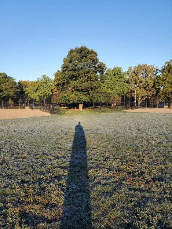
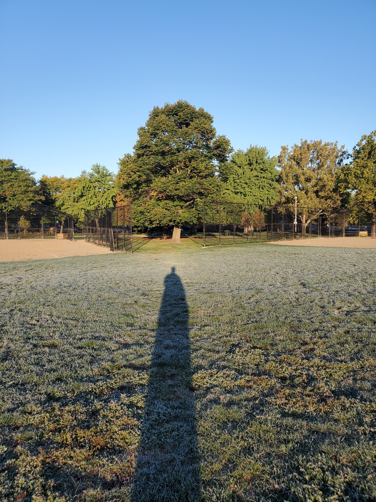
Low of 35 in my backyard, but frost in the center of Horner Park on Chicago's northwest side. Thought it was a pretty good example of a park being somewhat of an oasis in the urban heat island. The grass on the edges of the park was only dewy but frost in the center.
Sorry for the dementor shadow
-
2
-
-
21 hours ago, MIstorm97 said:
Thinking of heading up north next weekend for fall colors. Loving these crisp sunny days and cool nights.
I'm in St Helen and was in Grayling yesterday, colors have only just started up here. Maybe ~10% of trees
-
1
-


February 2024 General Discussion
in Lakes/Ohio Valley
Posted
So how are things looking in the UP @weatherbo and @wishforsnow? Any trails open at all?