

OKTWISTER
-
Posts
75 -
Joined
-
Last visited
Content Type
Profiles
Blogs
Forums
American Weather
Media Demo
Store
Gallery
Posts posted by OKTWISTER
-
-
Looks like the SPC is slowly upping the chances for severe storms this week. May be the start of the spring season with some decent moisture return possible. We will have to watch this system as there could be some decent but limited storms.
  Day 4-8 Convective Outlook
   NWS Storm Prediction Center Norman OK
   0358 AM CST Sun Mar 07 2021

   Valid 101200Z - 151200Z

   ...DISCUSSION...
   ...Wednesday/Day 4 and Thursday/Day 5...
   The medium-range models start out the day 4 to 8 period in decent
   agreement. For Wednesday, the various solutions have an upper-level
   low near the coast of California and show southwest mid-level flow
   from the Desert Southwest northeastward across much of the central
   and eastern U.S. At the surface, a cold front is forecast to be
   located in the central Plains and Upper Midwest. Thunderstorms will
   be possible along the front from late Wednesday afternoon into the
   overnight period. The most likely corridor for convective
   development would along and ahead of the front, from northern
   sections of the southern Plains northeastward into the mid to upper
   Mississippi Valley. With surface dewpoints forecast to be in the 50s
   F ahead of the front, instability should remain weak. However,
   deep-layer shear is forecast to strong, making a severe threat
   possible in spite of the weak instability. The potential for severe
   storms could be maximized in Oklahoma and eastern Kansas Wednesday
   night, where low-level flow and moisture are forecast to be the
   greatest.

   Southwest-mid-level flow is forecast to be maintained on Thursday
   from the south-central U.S. into to the northeastern states. At the
   surface by late Thursday afternoon, a cold front is forecast to be
   located from northern sections of the southern Plains northeastward
   into the southern Great Lakes. The ECMWF, GFS, UKMET and Canadian
   models are reasonably close with the front position at 00Z/Friday.
   The models suggest that convection will develop along the front from
   late Thursday afternoon and persist through the evening and into the
   overnight period. The strongest instability is forecast in the
   southern Plains while the strongest deep-layer shear is forecast
   much further northeast into the mid Mississippi Valley and southern
   Great Lakes. In addition, many of the GEFS members have a shortwave
   ridge located in the south-central U.S. Thursday night. Although a
   severe threat could develop Thursday evening along and ahead of much
   of the front, the factors previously mentioned make the forecast
   magnitude of any severe threat highly uncertain.

   ...Friday/Day 6 to Sunday/Day 8...
   On Friday, the medium-range models diverge sharply. Model solutions
   vary on the position and strength of the upper-level low across the
   western U.S. This will impact the forecast further to the east
   across the Great Plains and lower to mid Mississippi Valley. The
   models do show a moist airmass in place across the southern Plains
   and lower Mississippi Valley. A cold front is forecast from Oklahoma
   eastward into the mid Mississippi Valley but some solutions have the
   front further to the south than others, such as the ECMWF. Severe
   thunderstorm development could occur near the front Friday afternoon
   and evening. The strongest instability would be in the southern
   Plains suggesting the severe threat would be maximized from north
   Texas into Oklahoma. A threat area may need to be added in later
   outlooks, once the models show run-to-run consistency and certainty
   increases.

   On Saturday and Sunday, the models sharply diverge on the
   upper-level pattern. Some solutions move the upper-level eastward
   into the central states while others weaken the upper-level low.
   There is a large spread in GEFS members as well. If the upper-level
   low does move eastward into the Great Plains, a substantial severe
   threat would be possible ahead of the system Saturday afternoon and
   evening. The severe threat could redevelop further to the east along
   and ahead of a cold front on Sunday in the Mississippi Valley. This
   scenario will be dependent upon the upper-level low moving eastward
   into the central U.S. If the upper-level gradually weakens, as the
   ECMWF solution suggests, the severe threat in the south-central and
   southeastern U.S. would be much more localized. For the reasons
   previously stated, predictability is low for Saturday and Sunday.
-
 1
1
-
-

URGENT - IMMEDIATE BROADCAST REQUESTED Tornado Watch Number 13 NWS Storm Prediction Center Norman OK 220 PM CST Sun Feb 28 2021 The NWS Storm Prediction Center has issued a * Tornado Watch for portions of Central and Eastern Arkansas Southwest Kentucky Missouri Bootheel Northern Mississippi Western and Middle Tennessee * Effective this Sunday afternoon and evening from 220 PM until 1000 PM CST. * Primary threats include... A few tornadoes likely Widespread damaging winds likely with isolated significant gusts to 75 mph possible Isolated very large hail events to 2 inches in diameter possible SUMMARY...Thunderstorms are forecast to develop across the watch area through the afternoon and evening hours - with a few intense thunderstorms expected. Damaging winds are the most likely threat, but large hail and a few tornadoes are also possible from the most organized storms. The tornado watch area is approximately along and 60 statute miles north and south of a line from 20 miles southwest of Hot Springs AR to 15 miles east northeast of Nashville TN. For a complete depiction of the watch see the associated watch outline update (WOUS64 KWNS WOU3). PRECAUTIONARY/PREPAREDNESS ACTIONS... REMEMBER...A Tornado Watch means conditions are favorable for tornadoes and severe thunderstorms in and close to the watch area. Persons in these areas should be on the lookout for threatening weather conditions and listen for later statements and possible warnings. -
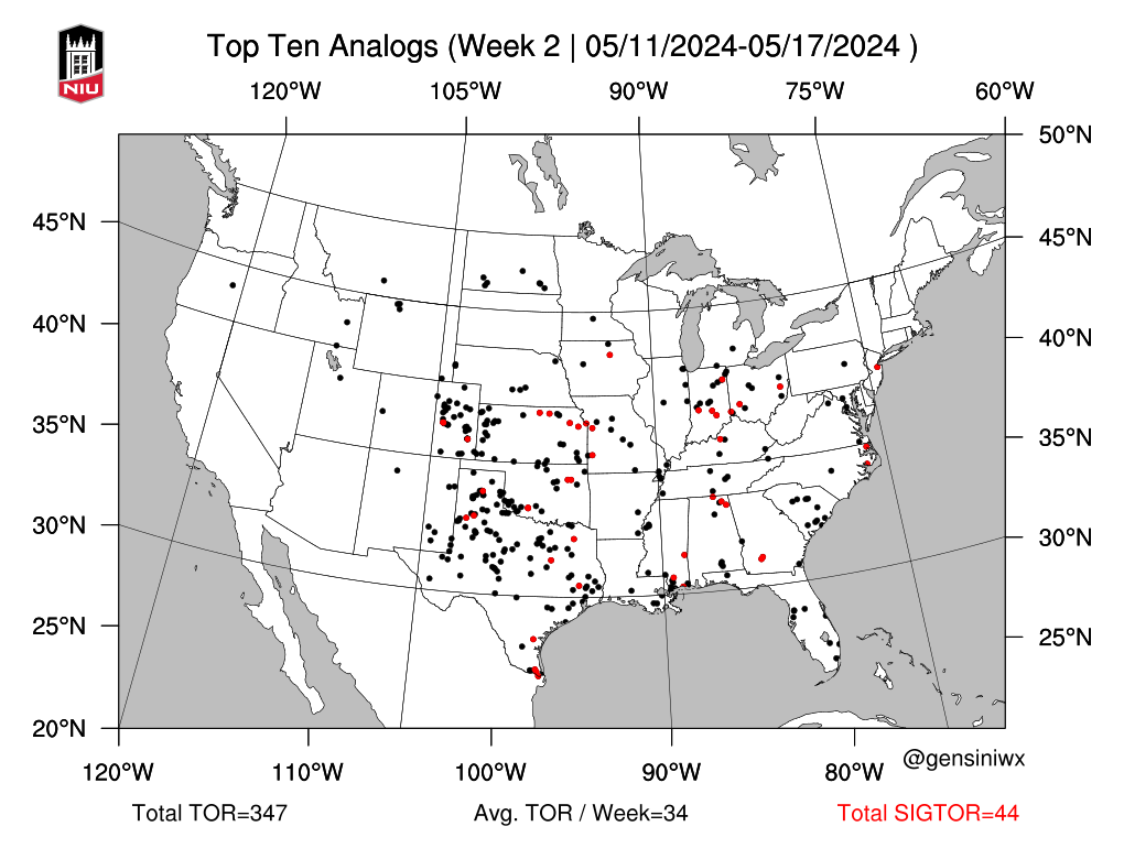
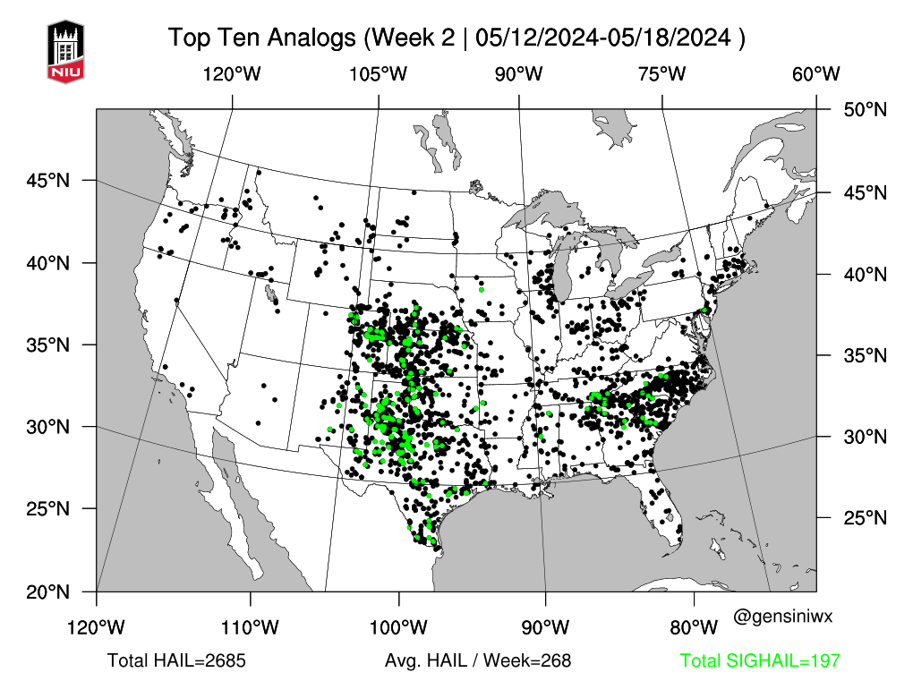
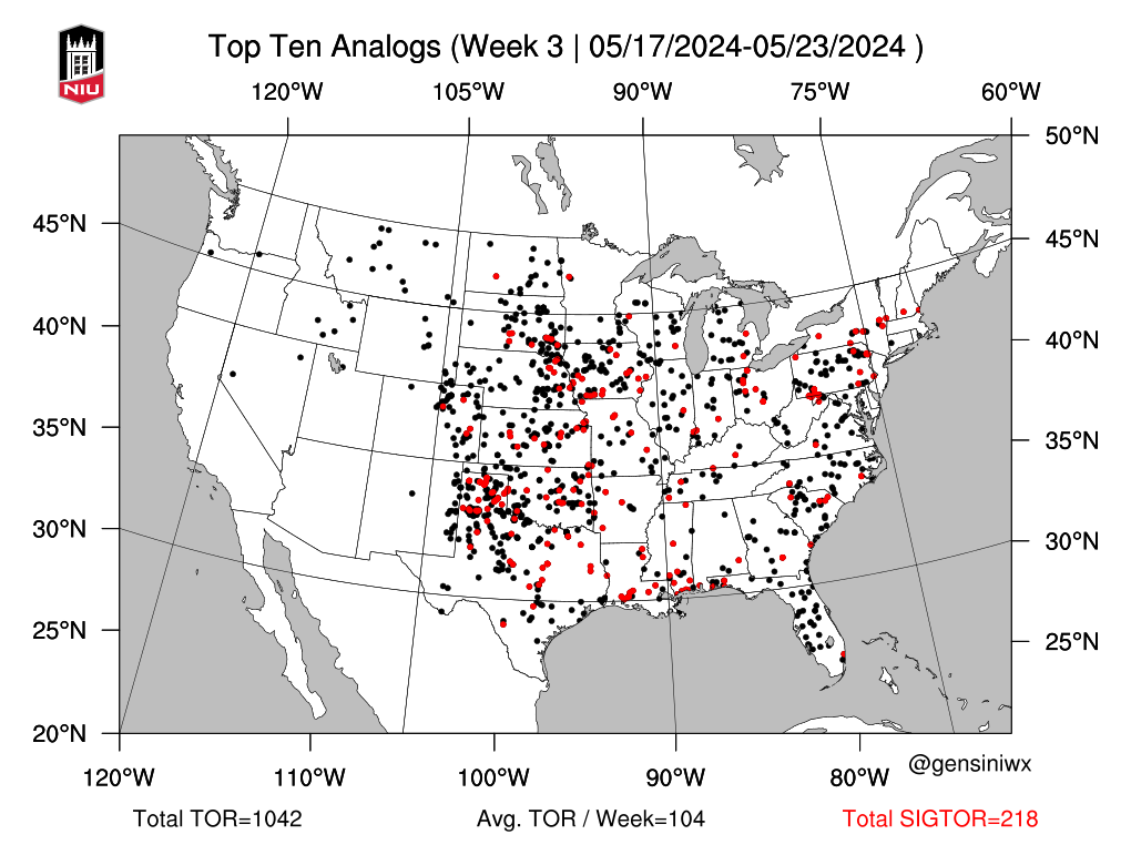
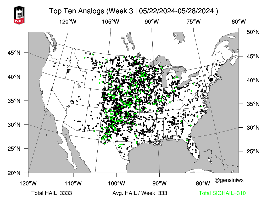
So I came across some analogs for the first couple of weeks of March. I still think we will have a event in the middle part of March this year. Past events show that we could see a strong event and we are seeing some good moisture return to the SE from the Gulf of Mexico and if we can get the return with a dynamic system we could see some early spring magic.
-
We may have been the Oklahoma Arctic the last two weeks but give it a week and it will be severe season. I was reading this attached spring outlook and realized that if we do have an active season it could kick off very soon. CPC looks warmer and somewhat moist in the next couple of weeks so we could see a early March event start to show up. If we rock like the end of the La Nina in 2011 we could be very busy.
https://www.severe-weather.eu/long-range/spring-2021-first-weather-forecast-la-nina-usa-europe-fa/
-
1
-
-
Tulsa's temperature has been trending up the last few hours. Also NWS Tulsa does not have snow on their decision page at all for this week. Just some daily freezing drizzle and the arctic air timeline seems to be getting pushed back every day. I am starting to wonder how far the cold air will actually get to the south. A good snow storm with the cold is not looking too promising right now.
...PERIODS OF FREEZING DRIZZLE EXPECTED THROUGH TOMORROW MORNING... Hazard Sun Mon Tue Wed Thu Fri Sat  FIRE DANGER

 ICE
WINDCHILL
ICE
WINDCHILL

VISIBILITY


-
StormChazer wake up it is snowing in Collinsville...............
-
I am up in Skiatook and have ice in the trees at the Walmart and winds gusting to 35 mph
-
1
-
-
Just now, StormChazer said:
Thanks for the scouting! I may hop on the car and drive over to Skiatook to see what it's like there, no ice yet in Collinsville, must be just a few decimal points above freezing here.
At 2353 on KOTV 6 you can see the icing I have at this point.
-
1
-
-
Finally have a 32 degree zone on the west side of Tulsa Metro. I am on Hwy 97 between Sapulpa and Sand Springs and have icing occurring on trees.,
Also reading the above I have not seen any sleet and have been on the road since 2030 hours.
-
2
-
-
-
Just now, StormChazer said:
100% this. What's the criteria anyhow? Greater than 1/2 the county to be included? 1/3? It's very unclear and doesn't paint a proper picture.
What if I end up, in Collinsville, getting an ice storm while Bixby skirts by with cold rain? If I wasn't weather savvy, I would be surprised because there was no advisory or warning due to the current format.
Because you are in Collinsville I expect rain from Owasso to Collinsville and 3-6 inches of snow in Bixby........
-
 3
3
-
-
1 minute ago, Wx 24/7 said:
One thing graphics like this reassure me is the need for polygon based winter products like we do with severe weather. Places like Sand Springs aren't in the advisory despite being further west than others in the advisory.
I agree and we know the line will be much different than the advisory area.
-
NWS Tulsa holding strong on little freezing precipitation in the Tulsa Metro proper. However the Winter Storm Warning was moved east and Osage and Pawnee counties added and Washington, Nowata and Craig counties added for Winter Weather Advisory.

-
Looking like mostly rain for Tulsa unless the system is more SE

-
First Tornado Watch issued:
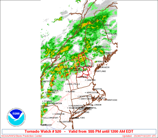
URGENT - IMMEDIATE BROADCAST REQUESTED Tornado Watch Number 520 NWS Storm Prediction Center Norman OK 740 AM CST Thu Dec 31 2020 The NWS Storm Prediction Center has issued a * Tornado Watch for portions of The upper Texas coastal plain Coastal Waters * Effective this Thursday morning and afternoon from 740 AM until 300 PM CST. * Primary threats include... A few tornadoes possible Scattered damaging wind gusts to 70 mph possible Isolated large hail events to 1 inch in diameter possible SUMMARY...Thunderstorms will increase in coverage and intensity through the morning while spreading inland across the upper Texas coast. The storm environment will gradually become more favorable for supercells inland, with an attendant threat for a few tornadoes and damaging winds through early to mid afternoon. The tornado watch area is approximately along and 40 statute miles north and south of a line from 25 miles west southwest of Angleton TX to 20 miles north northeast of Port Arthur TX. For a complete depiction of the watch see the associated watch outline update (WOUS64 KWNS WOU0). PRECAUTIONARY/PREPAREDNESS ACTIONS... REMEMBER...A Tornado Watch means conditions are favorable for tornadoes and severe thunderstorms in and close to the watch area. Persons in these areas should be on the lookout for threatening weather conditions and listen for later statements and possible warnings. && AVIATION...Tornadoes and a few severe thunderstorms with hail surface and aloft to 1 inch. Extreme turbulence and surface wind gusts to 60 knots. A few cumulonimbi with maximum tops to 400. Mean storm motion vector 21035. -
9 minutes ago, The Waterboy said:
Does “sharper upper level trough” mean further west? I’m not sure how to interpret that.
That sounds like We really do not know what the system is going to do and tomorrow could be totally different....
-
1
-
-
Looks like CPC is not sold on that cold air at this time.

-
So if Eta makes landfall on the south as a tropical storm and later hits further north as a hurricane does that count as two separate landfalls for records or is it still considered one landfalling storm?
-
34 minutes ago, Moderately Unstable said:
OKTWISTER: 932mb/140kts
-
 1
1
-
1
-
-
I am going 932 mb and 155 mph
-
Has anyone used the SiOnyx Aurora video camera to shoot storms at night? If so how did it turn out.
-
Small set up for tomorrow in NE OK and SW Mo to NW AR, currently we have a cold front draped across NE OK that is forecast to move back north. Dew points have been high today just muggy outside. Wind and hail are the main threat but NWS Tulsa and SPC mention tornadoes and Day 2 is up to 5% area. Could be a sleeper day and I would not be surprised to see a upgrade to Enhanced tomorrow.


March 17-18 Severe Weather Event
in Southeastern States
Posted