

OKTWISTER
-
Posts
75 -
Joined
-
Last visited
Content Type
Profiles
Blogs
Forums
American Weather
Media Demo
Store
Gallery
Posts posted by OKTWISTER
-
-
6 minutes ago, cheese007 said:
Looked like a powerflash on the webcam stream
Cams down now
-
Might get another Tornado Emergency soon I am afraid
Lots of radar CC moving into Bowling Green
-
That south one ramped up on last radar pass and looks to move into populated area Memphis Junction and S. Bowling Green if it holds
-
So which side of Bowling Green is the Corvette factory?
Ramping back up heading towards Gasper
-
May be more than one tornado running from NW of Elkton to south of it.
Latest scan south tornado may become dominate
Daysville in line of this tornado
-
1 minute ago, Mrklem10 said:
Hopefully the new stuff chokes it off!
Not soon it looks like it intensified again
-
As much damage as this is doing and how long the path is there may be persons trapped in rural areas for long periods before anyone can get to them.
-
I see the one report Samburg TN direct hit on fire station with collapse and persons trapped
-
 1
1
-
-
4 minutes ago, jaxjagman said:
Coming back
Looks like it cycled but may never have lifted NROT up last few scans
Hail is 3 inch plus on that cell
-
3 minutes ago, jaxjagman said:
Died again
Some what away from a good radar read right now
looking like it has dropped intensity quite a bit
-
Mississippi AR-Pemiscot MO-Dunklin MO-Dyer TN-Lake TN-
753 PM CST Fri Dec 10 2021...TORNADO EMERGENCY FOR Southern Dunklin and Pemiscot
counties including Denton and Steele......A TORNADO WARNING REMAINS IN EFFECT UNTIL 815 PM CST FOR NORTH
CENTRAL MISSISSIPPI...PEMISCOT...SOUTHEASTERN DUNKLIN...NORTHWESTERN
DYER AND SOUTHWESTERN LAKE COUNTIES...
At 751 PM CST, a confirmed large and destructive tornado was located
near Hornersville, or 7 miles north of Gosnell, moving northeast at
50 mph.TORNADO EMERGENCY for Southern Dunklin and Pemiscot counties
including Denton and Steele. This is a PARTICULARLY DANGEROUS
SITUATION. TAKE COVER NOW!HAZARD...Deadly tornado.
-
Pretty quite over here for an ongoing outbreak. Looks like a major tornado hit close to Monette AR and is moving into Leachville AR with a lot of debris showing up on radar
-
5 minutes ago, jaxjagman said:
3 NOW

That NROT was off the top of the chart when it went pink/white
Large debris ball and CC drop out now.
-
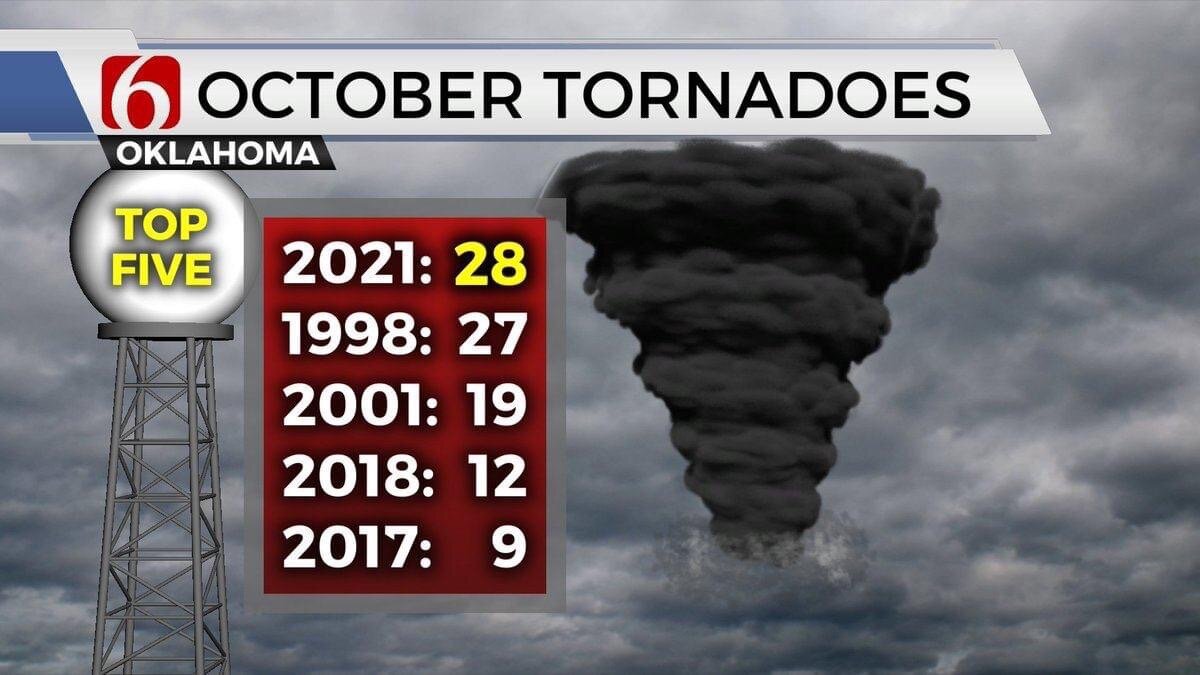
OKLAHOMA OCTOBER TORNADO RECORD SET: MORE TO COME?


 Day 4-8 Convective Outlook
   NWS Storm Prediction Center Norman OK
   0318 AM CDT Thu Oct 21 2021

   Valid 241200Z - 291200Z

   ...DISCUSSION...
   (Day 4) Models are trending toward better agreement and have
   demonstrated some run-to-run consistency regarding the evolution of
   a southern-stream shortwave trough forecast to amplify as it
   approaches the southern and central High Plains Saturday night. This
   feature will move through the central/southern Plains Sunday before
   reaching the middle/lower MS Valley Sunday evening. There are still
   some model differences, particularly with regard to the amplitude
   and speed of this system.

   Deepening lee low should be situated over central KS by 12Z Sunday
   with a trailing cold front extending southwestward into western TX.
   A warm front will stretch eastward from the low through northern KS
   and into central MO. Partially modified Gulf air will advect through
   the warm sector beneath steeper mid-level lapse rates resulting in
   moderate instability during the afternoon. A capping inversion will
   delay surface-based thunderstorm initiation until mid afternoon when
   storms will likely develop along the cold front across central
   eastern KS into eastern OK as well as farther east along the warm
   conveyor belt into the lower MS Valley. Vertical wind profiles will
   support organized storms including supercells with potential for all
   severe hazards. Given some lingering model differences, will only
   introduce 15% category for this outlook, but higher probabilities
   might be warranted with better model agreement in later updates.

   (Day 5) - A severe threat will probably persist as this feature
   continues into the TN Valley region Monday and possibly the Middle
   Atlantic region Tuesday. However, model difference become more
   substantial at this time frame, so will defer introduction of any
   categorical risk areas to possibly the next update.

   (Days 6-7) - Models including most ensemble members are in
   reasonable agreement regarding the approach of an upper trough into
   the Plains with robust moisture return toward the early and middle
   part of next week. If these trends continue, a severe risk area may
   be introduced for portions of the central and southern Plains in the
   next 4-8 outlook update.
-
16 minutes ago, Iceresistance said:
I wished that the Norman-NWS has this . . .
Click on chicklets and open more information.
-
1 hour ago, Iceresistance said:
Where did you get this from?
-
 1
1
-
-
Slight shift north brings Tulsa into the Enhanced zone but NWS Tulsa still believes main threat will be SSW of Tulsa. Interesting what pasted is not what is showing on NWS Tulsa right now. They pulled tornado threat further north on the latest graphic.


-
I think Thursday will be upgraded to a Moderate Risk for S. KS and N. OK. The upgrade would be for wind and hail but the 10% tornado hatch this morning may also be expanded.

-
1 minute ago, mob1 said:
15 percent hatched tornado contour added to the morning update.

-
2
-
-
Looking at the NWS Tulsa Discussion today I think the better chance of a strong tornado may be SE/SC KS near the boundary. Will have to see where that is in the afternoon I think with no cap it will line up quickly and become a wind event. I also hate QLCS tornadoes as they are not going to be easy to see as everything is going to be in heavy precipitation with possible flash flooding issues. It is almost feeling like Derecho time.
Tomorrow will finally signify a change in the upper level pattern,
switching from the southerly flow aloft that has been providing a
steady stream of clouds and moisture form the Gulf over a majority
of the past two weeks. More westerly flow aloft will arrive
Wednesday, which should aid in clearing out some of the clouds and
providing the region with some sunshine. With the sunshine comes
warming temperatures with highs climbing back to near and above
average for the next few days. The main focus in this period
continues to be the threat for some significant severe weather to
affect the area Thursday afternoon and especially into the evening
and overnight hours. Thursday afternoon will be warm and moist
ahead of a frontal boundary that will be draped across southern
Kansas during the afternoon hours. Large instability and little to
no cap could lead to supercell development in the afternoon
across northeast Oklahoma. All hazards would be possible with this
initial development, although it is less certain that storms will
fire in this area with the lack of large scale forcing in place.
More likely is that storms will develop along the boundary in
southern Kansas by late afternoon and grow upscale into a large
convective complex that will then surge south across the area. A
large swath of damaging wind gusts will be possible with this
line. Additionally, low level shear will still be in place ahead
of the line and the possibility for tornadoes to develop along
the leading edge will be possible as well. continue to monitor the
latest forecast updates for more details.
-
Latest from NWS Tulsa for Thursday.
Hazardous Weather Outlook
National Weather Service Tulsa OK
147 PM CDT Tue May 25 2021

ARZ001-002-010-011-019-020-029-OKZ049-053>076-261045-
Adair OK-Benton AR-Carroll AR-Cherokee OK-Choctaw OK-Craig OK-
Crawford AR-Creek OK-Delaware OK-Franklin AR-Haskell OK-Latimer OK-
Le Flore OK-Madison AR-Mayes OK-McIntosh OK-Muskogee OK-Nowata OK-
Okfuskee OK-Okmulgee OK-Osage OK-Ottawa OK-Pawnee OK-Pittsburg OK-
Pushmataha OK-Rogers OK-Sebastian AR-Sequoyah OK-Tulsa OK-Wagoner OK-
Washington OK-Washington AR-
147 PM CDT Tue May 25 2021

This Outlook is for Northwest and West Central Arkansas as well as
much of Eastern Oklahoma.

.DAY ONE...This Afternoon and Tonight.

SEVERE THUNDERSTORM.
RISK...Limited.
AREA...Far Southeast Oklahoma.
ONSET...Ongoing...ending by early evening.

FLASH FLOOD.
RISK...Limited.
AREA...Southeast Oklahoma; Northwest Arkansas.
ONSET...Ongoing.

HEAVY RAIN.
RISK...Limited.
AREA...Southeast Oklahoma; Northwest Arkansas.
ONSET...Ongoing.

DISCUSSION...

There is a limited severe storm risk mainly across southeast
Oklahoma this afternoon. Damaging winds are the main threat.
Locally heavy rainfall fell across portions of southeast Oklahoma
this afternoon, shifting into northwest Arkansas. Another round of
heavy rain is possible with the afternoon storms over the same
areas. Thus, there is limited flash flood potential thru early
evening.

SPOTTER AND EMERGENCY MANAGEMENT ACTION STATEMENT...
Local Spotter Activation May Be Needed.

.DAYS TWO THROUGH SEVEN...Wednesday through Monday.
WEDNESDAY...Thunderstorm Potential.
THURSDAY...Severe Thunderstorm Potential...High Wind Potential...Heavy Rain Potential.
FRIDAY thru MONDAY...Thunderstorm Potential.

EXTENDED DISCUSSION...

Storm coverage on Wednesday will be isolated at best and during
the afternoon, mainly across far eastern Oklahoma and western
Arkansas. Severe weather is not expected.

A high impact weather event is expected from Thursday afternoon
and night. Severe storms are expected to form ahead of a cool
front across northeast Oklahoma Thursday afternoon and then grow
into a complex and move into western Arkansas and southeast
Oklahoma Thursday night. The initial storms across northeast
Oklahoma will pose the threat for tornadoes, very large hail to 2
inches in diameter or greater, and damaging winds. Due to the very
unstable airmass expected to be in place, and the potential for a
boundary to be draped across the region, there is potential for a
strong tornado. After storms congeal into a complex, wider swaths
of damaging winds will become the main severe concern. The severe
threat on Friday afternoon will be confined mainly to southeast
Oklahoma ahead of a cool front.

While storm chances remain in the forecast thru the weekend and
into early next week, severe weather is not expected during this
time.

Repeated heavy rainfall on top of saturated soils may lead to
an increasing flood threat later this week in addition to the
severe weather potential.
-
1
-
-
The NWS Tulsa is backing way off on the severe weather next week up in the Tulsa area. Looks like timing and the system going further south really cut back the threat.
NWS TULSA
DISCUSSION...
A few showers will linger across the area this morning as an upper
system departs to the east, with the greatest coverage of showers
across far eastern Oklahoma and northwest Arkansas. Skies will
clear this afternoon, but breezy northerly winds will keep
temperatures below the seasonal normals.

Strong southerly winds return Sunday through Tuesday, which will
result in temperatures warming to much above normal levels early
next week. Recent trends in the data suggest a slower, more
southerly track to the next storm system that will affect the area
during the middle part of next week. While there certainly remains
some severe weather potential with this system, heavy rainfall and
flash flooding may eventually become a bigger concern given the
slower southerly track. Several rounds of showers and storms will
likely occur from late Tuesday night through Thursday before this
system finally exits our area, bringing drier weather with near
seasonable temperatures heading into next weekend.

Adjusted the National Blend of Models pops and temperatures some
with the midweek system to account for the slower timing, but
otherwise stayed fairly close to the NBM forecast.
-

Day 4-8 Convective Outlook
   NWS Storm Prediction Center Norman OK
   0344 AM CDT Sat Apr 03 2021

   Valid 061200Z - 111200Z

   ...DISCUSSION...
   Medium-range model guidance is converging towards a scenario of a
   western U.S. trough evolving into a closed mid-level low over the
   central U.S. during the early half of the extended period.  Severe
   potential will likely focus on Tuesday across KS and possibly OK
   near a dryline with storms developing eastward overnight.
   Uncertainty remains regarding moisture quality and capping concerns
   but hail/wind are the main threats with this activity.  Higher
   confidence exists for organized severe storms on Wednesday from the
   Ozarks eastward to the MS Valley as high momentum flow overspreads a
   potential moderately unstable boundary layer centered on Arkansas.
   All hazards are possible.  A separate bi-modal area of concern could
   develop farther north but there is low confidence in this scenario.
   Uncertainty increases by Thursday owing in part to model spread and
   potential consequential effects of appreciable convective
   overturning for areas farther east/southeast on Thursday (day 6).
   Model variability increases during the latter part of the extended
   period.
Not much but something in a very dry period.....
Hazardous Weather Outlook
National Weather Service Tulsa OK
446 PM CDT Sat Apr 3 2021

ARZ001-002-010-011-019-020-029-OKZ049-053>076-041030-
Adair OK-Benton AR-Carroll AR-Cherokee OK-Choctaw OK-Craig OK-
Crawford AR-Creek OK-Delaware OK-Franklin AR-Haskell OK-Latimer OK-
Le Flore OK-Madison AR-Mayes OK-McIntosh OK-Muskogee OK-Nowata OK-
Okfuskee OK-Okmulgee OK-Osage OK-Ottawa OK-Pawnee OK-Pittsburg OK-
Pushmataha OK-Rogers OK-Sebastian AR-Sequoyah OK-Tulsa OK-Wagoner OK-
Washington OK-Washington AR-
446 PM CDT Sat Apr 3 2021

This Outlook is for Northwest and West Central Arkansas as well as
much of Eastern Oklahoma.

.DAY ONE...Today and Tonight.

SIGNIFICANT WINDS.
RISK...Limited.
    AREA...Northeast Oklahoma.
    ONSET...Ongoing...diminishing around sunset.

FIRE WEATHER DANGER.
RISK...Elevated.
AREA...Northeast Oklahoma and Far Northwest Arkansas.
ONSET...Ongoing...improving around sunset.

DISCUSSION...
Winds gusting 15 to 25 mph will remain common through the early
evening hours. These winds along with warm temperatures and low
humidity values will continue to support high grassland fire
spread rates across much of northeast Oklahoma and far northwest
Arkansas. Winds will decrease around sunset and fire weather
conditions will improve.

SPOTTER AND EMERGENCY MANAGEMENT ACTION STATEMENT...
Spotter Activation Not Expected.

.DAYS TWO THROUGH SEVEN...Sunday through Friday.
SUNDAY...High Fire Weather Potential.
MONDAY...High Fire Weather and High Wind Potential.
TUESDAY...Thunderstorm, High Fire Weather and High Wind Potential.
WEDNESDAY...Strong to Severe Thunderstorm, High Fire Weather and
High Wind Potential.
THURSDAY...High Fire Weather Potential.
FRIDAY...No Hazards.

EXTENDED DISCUSSION...
Warm and windy conditions will elevate fire weather concerns this
weekend and into much of next week. A storm system will move
into the Plains Wednesday. A few strong to severe storms may
develop across far eastern Oklahoma and western Arkansas
Wednesday afternoon.
-
1
-
-
11 minutes ago, Upper Level LOL said:
This is needlessly scaremongering and doesn't fit the parameters we see. We're going to see a lot of low-end tornadoes since the warm sector has essentially no cap. This will prevent bigger storms from firing. The threat of tomorrow aren't EF4-EF5s, but a firehose of EF2's and EF3's. I hope your reputation among your friends and family doesn't suffer from crying wolf about this.
I don’t know how many EF3 tornadoes in a metro area you have worked but several EF 3 tornadoes is not crying wolf. Very significant threat with nighttime tornadoes irregardless of ultimate ratings.
-
1
-

Dec. 10-11 Severe Weather
in Lakes/Ohio Valley
Posted
That is a lot of debris