

OKTWISTER
-
Posts
73 -
Joined
-
Last visited
Content Type
Profiles
Blogs
Forums
American Weather
Media Demo
Store
Gallery
Posts posted by OKTWISTER
-
-
-
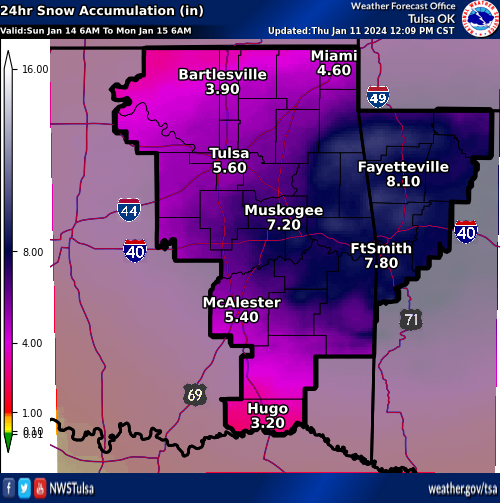
NWS Tulsa getting onboard for more snow on Sunday.
-
 1
1
-
-
4 minutes ago, Ed, snow and hurricane fan said:
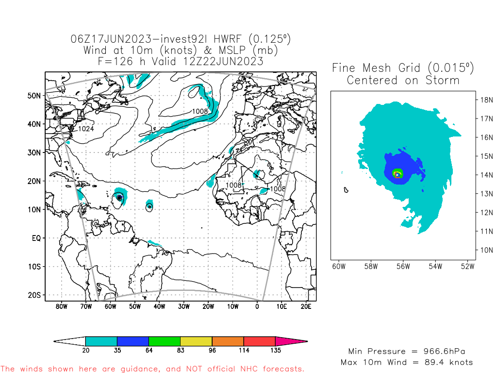
HWRF for 92L, and some GEFS and ECENS have a friend following in the footsteps of what likely becomes Arlene.
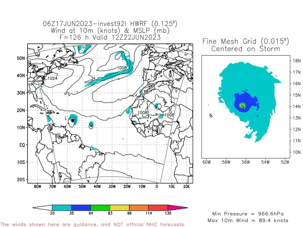

Arlene has been used.
-
1
-
-
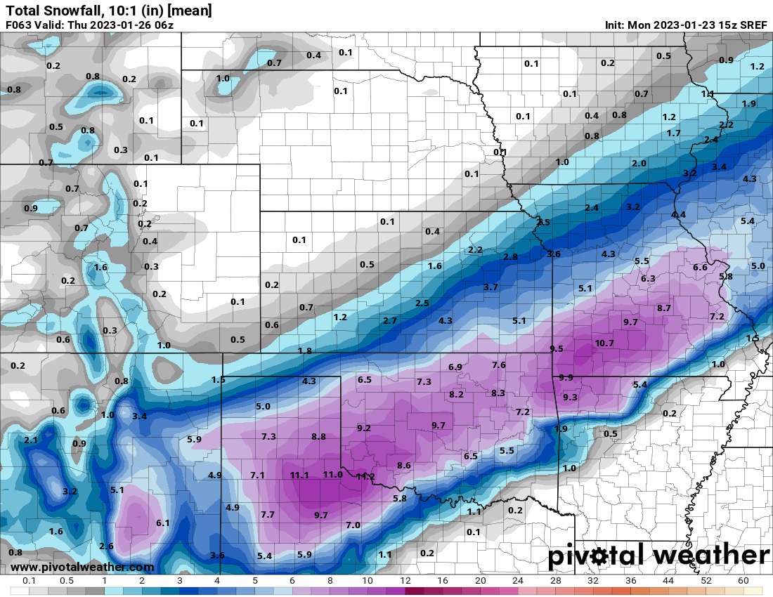
You can not rule out a June Oklahoma event. Tomorrow marks the anniversary of the June 8, 1974 outbreak. Look at page two the graph very impressive event.
-
1
-
-
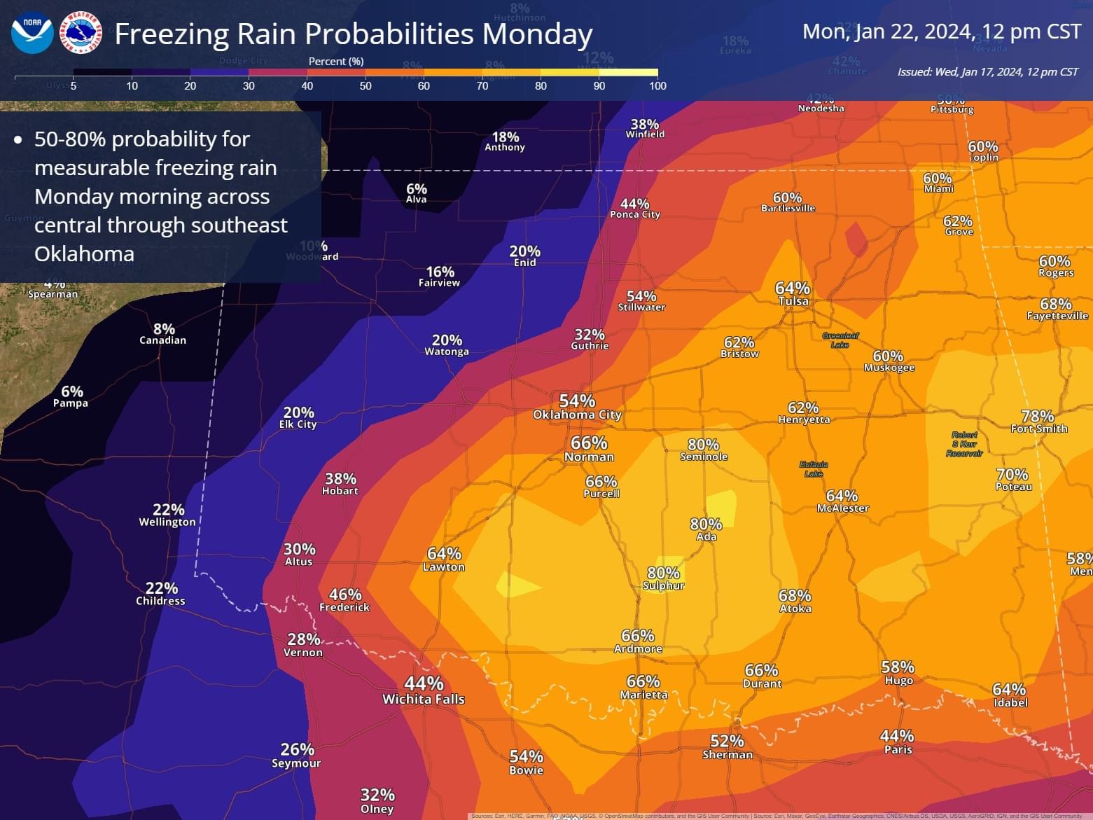
NWS Norman update on 2/26/23 event: https://www.weather.gov/oun/events-20230226
-
SPC
Surface dewpoints will probably
   reach the lower-mid 60s in the Arklatex on Wednesday into Wednesday
   night.  Model variability and greater confidence and a farther-west
   edge of low-level moisture/surface low placement in the southern
   Great Plains necessitated a shift of the severe probabilities west
   on Wednesday (day 5).  Once model spread is reduced, a 30-percent
   severe area will likely be introduced.
-
2
-
-

north trend
-
2
-
-
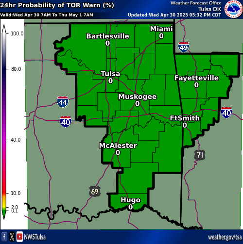
Looks like the system slowed down a bit allowing for a bit more severe weather to the west in E. OK. NWS Tulsa upped their tornado warning chart.
-
1
-
-
-
15 minutes ago, Hoosier said:
The president has been known to make gaffes (just stating a fact). Let's wait for actual numbers from officials.
I agree as I do not think the fatality total will be anywhere near the high numbers on the list, I just wanted to point out the hyperbole being said without facts even being known.
-
Thoughts today from NWS TULSA
Area Forecast Discussion
National Weather Service Tulsa OK
542 PM CST Sun Feb 20 2022


.LONG TERM...
(Monday through Sunday)
Issued at 221 PM CST Sun Feb 20 2022

The forecast becomes increasingly complex as we move into
Monday and especially during the Wednesday/Thursday time-frame.
From the potential of severe storms Monday night into Tuesday
morning to a wintry mess mid-week.

Scattered showers and thunderstorms are expected to bubble up
early Monday evening across southeast Oklahoma in advance of
a cold front that is set to move through the area Monday night
into Tuesday morning. In addition to the lift provided by
the frontal boundary, a weakening disturbance in the developing
southwesterly flow aloft will provide additional lift. There
will be adequate instability and shear for some of the storms
to become strong to severe. Large hail and damaging winds will
be the main concern. However, there is a low potential for
a tornado if a storm can remain surface based in the vicinity
of the cold front. The greatest potential for severe storms
will be across southeast Oklahoma into western Arkansas Monday
night into Tuesday morning. In addition to the potential for severe
weather, locally heavy rain will also be possible with precipitable
water values around 1.5 inches during this time. Again, the heaviest
rain will likely fall across southeast Oklahoma into western Arkansas.
1 to 2 inches of rain will be fairly common across this area with
local amounts around 4 inches possible. This could lead to flooding
of low lying areas. Have opted to not issue a Flash Flood Watch at
this time. However, later shifts will monitor closely and issue a
watch if necessary. The showers and storms are forecast to come to
an end Tuesday morning as the cold front exits the region.

Temperatures will be noticeably colder Tuesday and especially
Tuesday night. Temperatures are expected to bottom out in the
teens and twenties Tuesday night/Wednesday morning setting the
stage for the potential of a wintry mess mid-week.

With the cold air in place at the surface, at least two rounds of
wintry weather are expected to sweep across eastern Oklahoma
and western Arkansas Wednesday into Thursday. The southwesterly
flow aloft will help provide the isentropic lift for the first
round of wintry precipitation beginning Wednesday morning and
continuing into Wednesday night. The second round will run from
Thursday morning into Thursday evening as as mid-level shortwave
ejects out of the Southwest US and across the area. During both
of these periods all modes of winter weather will be possible.
However, it is looking more likely that a good portion of eastern
Oklahoma and western Arkansas will see more sleet and freezing
rain than snow. Significant impacts from the sleet and ice are
looking possible. Precipitation types and amounts will continue
to be refined as the event draws closer. Stay tuned.

After a dry yet chilly Friday, another chance of a wintry mix
will come Saturday into Saturday night as a another mid-level
shortwave sweeps across the area.
-
9 hours ago, Chinook said:
I guess this isn't getting a lot of discussion, but may very well be a dangerous tornado outbreak
There is too much throwing out the word outbreak with limited data to back it up. Again today was not an outbreak by any means not even close. If the hype is all that is put out you will see people not believing it when the data really supports it. Remember part of the issue that was looked at after Joplin was the number of tornado warnings issued by NWS Springfield that were not backed up by what really was occuring.
-
1
-
-
This system was a bust for OK. Cold air was ahead of models and limited severe weather to the Red River area, one tornado warning in Stephens County. I had some freezing rain near Ralston OK. I found a pretty good area of freezing rain in Lenapah and then there was sleet and snow very light near South Coffeyville. No where did I find warning criteria weather. Winds suck....
-
Looks like a good chance for severe weather in OK/TX and points east next Wednesday and Thursday. Could be a Dixie outbreak. Still many change in the forecast expected but early indications are good for a multi day severe event. Oh and dare I forget the snow in W OK and KS with the storm all the way into N. Michigan.
SPC
 Day 4-8 Convective Outlook
   NWS Storm Prediction Center Norman OK
   0332 AM CST Fri Feb 11 2022

   Valid 141200Z - 191200Z

   ...DISCUSSION...
   Medium-range guidance is in good agreement that a strong shortwave
   trough will drop southward from the Pacific Northwest into southern
   CA on D4/Monday and D5/Tuesday. This shortwave is then expected to
   eject eastward across the Southwest/northern Mexico into the
   southern Plains on D6/Wednesday before continuing northeastward
   across the Mid MS Valley and Lower/Middle OH Valley on D7/Thursday.

   Very strong mid-level flow will accompany the shortwave, with strong
   low-level flow anticipated throughout the warm sector ahead of the
   shortwave as well. This strong low-level flow will contribute to
   robust moisture advection, with upper 50s dewpoints into southern OK
   and low 60s dewpoints through much of central TX by early
   D6/Wednesday evening. This moisture advection will continue on
   D7/Thursday, with upper 50s dewpoints likely reaching into the
   middle OH Valley by D7/Thursday evening.

   The combination of lift, strong vertical shear, low-level moisture,
   and buoyancy will likely result in severe thunderstorms. Current
   guidance indicates the most probable location for severe storms on
   D6/Wednesday is from central TX northeastward across eastern OK,
   central/western AR, and northwest LA. For D7/Thursday, the severe
   risk extends from the Lower MS Valley through the Mid-South into the
   Lower OH Valley.
NWS TULSA DISC
.LONG TERM...
(Tonight through Thursday)
Issued at 316 AM CST Fri Feb 11 2022

Bottom line upfront: After a rather chilly weekend, expect warm
and windy weather for the first half of the week. Fire weather
concerns will be on the rise. Strong storm system arrives late
Wednesday into Thursday, with widespread rainfall and
thunderstorms expected. The average surface low track in the
latest data suggests this system has a low probability of
producing impactful wintry weather over our area at this point.
Details will continue to be refined in the coming days.

Digging shortwave trough over the central CONUS will force
aforementioned cold front thru the region this afternoon and
tonight. A few showers are possible ahead of the front as it moves
thru far southeast Oklahoma, but the better chances will be over
the ArkLaTex into early Saturday. Airmass behind this front will
be arctic in nature, but the brunt of this misses us to north and
east. Regardless, blended guidance (NBM) didn`t give it enough
respect and was toward the warm edge of the spread. Went with the
colder short term (CONSShort) guidance instead, with highs not
getting out of the 30s in most places. A secondary shortwave
trough dives southeast across the Midwest Saturday night into
Sunday, with a reinforcing push of arctic air coming south down
the center part of the country. The cold air will just glance us
this time but will still keep highs in check for Sunday.

Big pattern change comes next week, with deep cyclonic flow
developing over the western CONUS. SW flow over the Plains
downstream will induce lee troughing over the High Plains and a
tight gradient over us. Strong southerly flow and an expanding low
level thermal ridge will lead to a fast warmup thru Tuesday. Fire
weather concerns ramp up, with the highest spread indices on
Tuesday when winds will be strongest.

Upper low diving down the West Coast early in the week will pivot
around the base of the western CONUS trough and eject into the
Plains late Wednesday into Thursday. Widespread showers and storms
in the warm conveyor ahead of advancing system will overspread
the region Wednesday night, exiting Thursday morning. Some locally
heavy rainfall is possible. As far as severe weather potential is
concerned, sufficient deep layer shear will not be a question,
especially in the basal portion of a negative tilt shortwave
trough. Instability will be the main question. A significant
frontal intrusion into the Gulf basin by this weekend`s system
suggests that appreciable moisture may not arrive in time. Future
forecasts will refine this in the coming days. Regardless,
potential for thunder still appears larger than what the NBM
suggests, and have nudged those probs upward.

Colder air will push into the region on Thursday as the surface
low passes by. The main question at this point will be the track
of the surface low, which has big implications regarding our
winter weather potential. The latest deterministic GFS tracks the
surface low just to our north, keeping the wrap-around heavy snow
band to our north over Kansas. The latest ECMWF is a bit farther
south with these features, grazing NE OK with the snow band. We
are still several days out, and the details will continue to
adjust as we get closer. For now, will not go full boar with
winter weather potential, inserting low potential for snow and
light accums. Just too early to tell if this system will bring
winter weather impacts.

Lacy


-
Here we go NWS TULSA:
Public Information Statement
National Weather Service Tulsa OK
238 PM CST Thu Feb 3 2022

...SNOWFALL REPORTS...

Location                     Amount    Time/Date       Lat/Lon
3 ENE Rogers                 9.0 in    0202 PM 02/03   36.34N/94.06W
3 NNW Bella Vista            9.0 in    1044 AM 02/03   36.48N/94.25W
1 NNW Rogers                 7.5 in    1215 PM 02/03   36.35N/94.12W
Holiday Island 1.3 SSW       7.2 in    0700 AM 02/03   36.47N/93.74W
3 N Aurora                   7.0 in    0206 PM 02/03   36.03N/93.70W
1 S Garfield                 7.0 in    0110 PM 02/03   36.44N/93.97W
Lowell                       7.0 in    1250 PM 02/03   36.26N/94.14W
Hectorville                  7.0 in    0744 AM 02/03   35.85N/95.92W
Springdale                   6.5 in    0116 PM 02/03   36.19N/94.13W
1 SE Shady Grove             6.5 in    1215 PM 02/03   36.13N/94.13W
Rogers                       6.5 in    1000 AM 02/03   36.33N/94.13W
Siloam Springs 1.8 N         6.5 in    0930 AM 02/03   36.21N/94.55W
Centerton                    6.2 in    1115 AM 02/03   36.36N/94.29W
3 ENE Jenks                  6.2 in    0738 AM 02/03   36.03N/95.92W
Ochelata 5.6 N               6.2 in    0700 AM 02/03   36.68N/95.99W
Huntsville                   6.0 in    1246 PM 02/03   36.09N/93.74W
2 SE Wheeler                 6.0 in    1159 AM 02/03   36.09N/94.23W
6 W Claremore                6.0 in    0932 AM 02/03   36.32N/95.73W
Stilwell                     6.0 in    0920 AM 02/03   35.82N/94.63W
Bentonville                  6.0 in    0904 AM 02/03   36.37N/94.21W
4 SSE Jenks                  6.0 in    0748 AM 02/03   35.97N/95.94W
Eureka Springs               6.0 in    0748 AM 02/03   36.40N/93.75W
Pea Ridge 0.2 WSW            5.8 in    0800 AM 02/03   36.45N/94.12W
3 SSE Sperry                 5.6 in    0810 AM 02/03   36.26N/95.97W
2 W Fayetteville             5.5 in    0109 PM 02/03   36.06N/94.19W
Cleveland                    5.5 in    0940 AM 02/03   36.31N/96.46W
Bartlesville                 5.5 in    0930 AM 02/03   36.75N/95.98W
Eureka Springs 3.5 SW        5.5 in    0800 AM 02/03   36.37N/93.79W
6 NW Verdigris               5.5 in    0700 AM 02/03   36.30N/95.75W
Sand Springs 2.7 S           5.5 in    0700 AM 02/03   36.10N/96.13W
Claremore 7.5 W              5.5 in    0700 AM 02/03   36.30N/95.75W
3 E Owasso                   5.1 in    1252 PM 02/03   36.27N/95.81W
Jay 3.3 NNE                  5.1 in    0800 AM 02/03   36.47N/94.78W
3 S Collinsville             5.0 in    1158 AM 02/03   36.32N/95.85W
5 N Bixby                    5.0 in    1140 AM 02/03   36.01N/95.87W
1 NNW Hindsville             5.0 in    1100 AM 02/03   36.16N/93.87W
5 NE Hiwasse                 5.0 in    1049 AM 02/03   36.49N/94.28W
2 WSW Centerton              5.0 in    1047 AM 02/03   36.35N/94.32W
4 NE Tahlequah               5.0 in    0945 AM 02/03   35.96N/94.92W
4 SSE Tulsa                  5.0 in    0931 AM 02/03   36.07N/95.90W
Pryor                        5.0 in    0920 AM 02/03   36.31N/95.32W
2 NW Springdale              5.0 in    0920 AM 02/03   36.20N/94.15W
Hominy                       5.0 in    0920 AM 02/03   36.42N/96.39W
Westville                    5.0 in    0915 AM 02/03   35.99N/94.57W
Fayetteville                 5.0 in    0845 AM 02/03   36.06N/94.16W
1 SW Farmington              5.0 in    0817 AM 02/03   36.03N/94.27W
1 SW Bentonville             5.0 in    0815 AM 02/03   36.37N/94.22W
5 N Maysville                5.0 in    0749 AM 02/03   36.48N/94.61W
Wyandotte                    5.0 in    0715 AM 02/03   36.80N/94.73W
Rogers 2.4 SSW               5.0 in    0700 AM 02/03   36.30N/94.14W
1 ENE Prairie Grove          4.5 in    1042 AM 02/03   35.98N/94.30W
Tahlequah                    4.5 in    0930 AM 02/03   35.92N/94.97W
Tulsa 1.5 WNW                4.5 in    0800 AM 02/03   36.13N/95.94W
5 E Jenks                    4.5 in    0747 AM 02/03   36.02N/95.89W
Eureka Springs               4.5 in    0729 AM 02/03   36.39N/93.74W
3 E Sapulpa                  4.4 in    0938 AM 02/03   36.00N/96.07W
Owasso 4.6 ENE               4.2 in    0804 AM 02/03   36.30N/95.76W
1 SW Schulter                4.1 in    0959 AM 02/03   35.51N/95.96W
2 SE Cleora                  4.0 in    1204 PM 02/03   36.55N/94.95W
4 W Broken Arrow             4.0 in    1120 AM 02/03   36.05N/95.87W
1 SE Okmulgee                4.0 in    1030 AM 02/03   35.62N/95.95W
Bristow                      4.0 in    0950 AM 02/03   35.83N/96.39W
Colcord                      4.0 in    0940 AM 02/03   36.27N/94.69W
Vinita                       4.0 in    0920 AM 02/03   36.64N/95.15W
Vian                         4.0 in    0846 AM 02/03   35.50N/94.97W
Rogers                       4.0 in    0845 AM 02/03   36.33N/94.12W
Huntsville                   4.0 in    0812 AM 02/03   36.09N/93.74W
Drumright 0.6 SW             4.0 in    0730 AM 02/03   35.98N/96.61W
4 S Broken Arrow             3.8 in    0802 AM 02/03   36.00N/95.79W
Tulsa 8.4 ESE                3.8 in    0800 AM 02/03   36.10N/95.77W
3 W Broken Arrow             3.5 in    1048 AM 02/03   36.05N/95.85W
Mcalester                    3.5 in    0950 AM 02/03   34.94N/95.77W
3 N Sallisaw                 3.0 in    0201 PM 02/03   35.51N/94.79W
Checotah                     3.0 in    0143 PM 02/03   35.48N/95.52W
5 SSE Tulsa                  3.0 in    1158 AM 02/03   36.07N/95.89W
2 E Muskogee                 3.0 in    1025 AM 02/03   35.75N/95.33W
2.9 S Kingston               3.0 in    1009 AM 02/03   36.01N/93.52W
4 NE Okesa                   3.0 in    0920 AM 02/03   36.75N/96.07W
1 S Eureka Springs           3.0 in    0716 AM 02/03   36.38N/93.74W
Metalton 3.5 W               3.0 in    0700 AM 02/03   36.23N/93.59W
5 SE Kingston                2.5 in    0141 PM 02/03   36.01N/93.45W
Gore                         2.0 in    0940 AM 02/03   35.53N/95.11W
Muskogee                     2.0 in    0940 AM 02/03   35.75N/95.37W
Stigler                      2.0 in    0920 AM 02/03   35.26N/95.12W
Ketchum                      2.0 in    0757 AM 02/03   36.52N/95.03W
Pryor 2.2 SE                 2.0 in    0700 AM 02/03   36.27N/95.30W
1 NE Van Buren               1.5 in    0150 PM 02/03   35.45N/94.33W
Sallisaw 1.0 SE              1.3 in    0800 AM 02/03   35.45N/94.80W
Sallisaw                     1.0 in    0846 AM 02/03   35.46N/94.78W
Uniontown 2.1 ESE            1.0 in    0700 AM 02/03   35.57N/94.41W
5 SE Kingston                0.5 in    0826 AM 02/03   36.01N/93.45W
Antlers 6.3 SE               0.5 in    0800 AM 02/03   34.16N/95.54W

...SLEET REPORTS...

Location                     Amount    Time/Date       Lat/Lon
Talihina                     1.0 in    0840 AM 02/03   34.75N/95.05W
5 SE Kingston                1.0 in    0825 AM 02/03   36.01N/93.45W
Finley                       1.0 in    0809 AM 02/03   34.33N/95.49W
Soper                        0.8 in    0819 AM 02/03   34.03N/95.70W
Wilburton                    0.5 in    0953 AM 02/03   34.92N/95.31W
Rattan                       0.5 in    0827 AM 02/03   34.20N/95.41W
2 SE Cleora                  0.3 in    1205 PM 02/03   36.55N/94.95W

...FREEZING RAIN REPORTS...

Location                     Amount    Time/Date       Lat/Lon
Mulberry                     0.50 in   0930 AM 02/03   35.50N/94.05W
Talihina                     0.50 in   0838 AM 02/03   34.75N/95.05W
Honobia                      0.38 in   1045 AM 02/03   34.54N/94.94W
Hugo                         0.25 in   0820 AM 02/03   34.01N/95.52W
Soper                        0.25 in   0818 AM 02/03   34.03N/95.70W
Finley                       0.25 in   0809 AM 02/03   34.33N/95.49W
Rattan                       0.10 in   0827 AM 02/03   34.20N/95.41W

Observations are collected from a variety of sources with varying
equipment and exposures. We thank all volunteer weather observers
for their dedication. Not all data listed are considered official
-
 1
1
-
-
I have heavy snow in Morris on Hwy 62, going east I hit heavy sleet near the Okmulgee/Muskogee county line. Doubled back found the nose of sleet had pushed north and had sleet and snow mix until reaching Morris again.
-
1
-
-
So round 1, left Owasso about 0430 it was 35 degrees and drizzle. North on Hwy 75 hit ice on road about the Walmart distribution Center south of Bartlesville and continued with icy roads from sleet and freezing rain/drizzle. Hit Caney KS and was in heavy snow estimated the band at 2 inch per hour with visibility to about 50 yards or less with blowing drifting snow winds about 20-25 mph temp down to 20 degrees. South on Hwy 169 hit some ice on trees and roadway South of South Coffeyville.
Roads became glaze of ice from Nowata to Oolagah with vehicles sliding off road including a pickup overturned S. of Talala.
Home temp 25 back out later.............
-
1
-
-
I also think the cold air will be a bit ahead of schedule it looks to be entering the NW part of OK now.
http://www.mesonet.org/data/public/noaa/metar/maps/realtime/latest.tair.png
-
I still think 10-12 is possible up in the NE corner of OK.
-
3 minutes ago, StormChazer said:
You know...there is technically blizzard criteria wind gusts associated with this during the heavy snow..

With light weight snow there will be blowing and drifting for sure.
-
I think the sleet will be well south of I 44 now and that heavy snow event looks to be legit with the moisture and ratios in play.
-
1
-
-
11 minutes ago, andyhb said:
I have a bad feeling about I-44 particularly in OK with this one. Setup screams either a big sleet event with snow/ZR mixed in, or a nasty ice storm.
The magic I 44 line will be deciding once again. I am thinking a good sleet event in Tulsa metro with a great layer of ice for the snow to fall on allowing us to suffer with the cold for several days.
-
Just now, BuffaloWeather said:
Bowling green took a direct hit.


That is a lot of debris
-
6 minutes ago, cheese007 said:
Looked like a powerflash on the webcam stream
Cams down now


Severe Weather 4-15 and 4-16-24
in Central/Western States
Posted
We have lacked one or more ingredients so far this spring in OK that have minimized potential. This looks quite promising especially six days out.