

Snowstorm920
-
Posts
91 -
Joined
-
Last visited
Content Type
Profiles
Blogs
Forums
American Weather
Media Demo
Store
Gallery
Posts posted by Snowstorm920
-
-
Strong couplet just west of Akron, AL
-
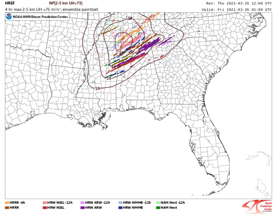
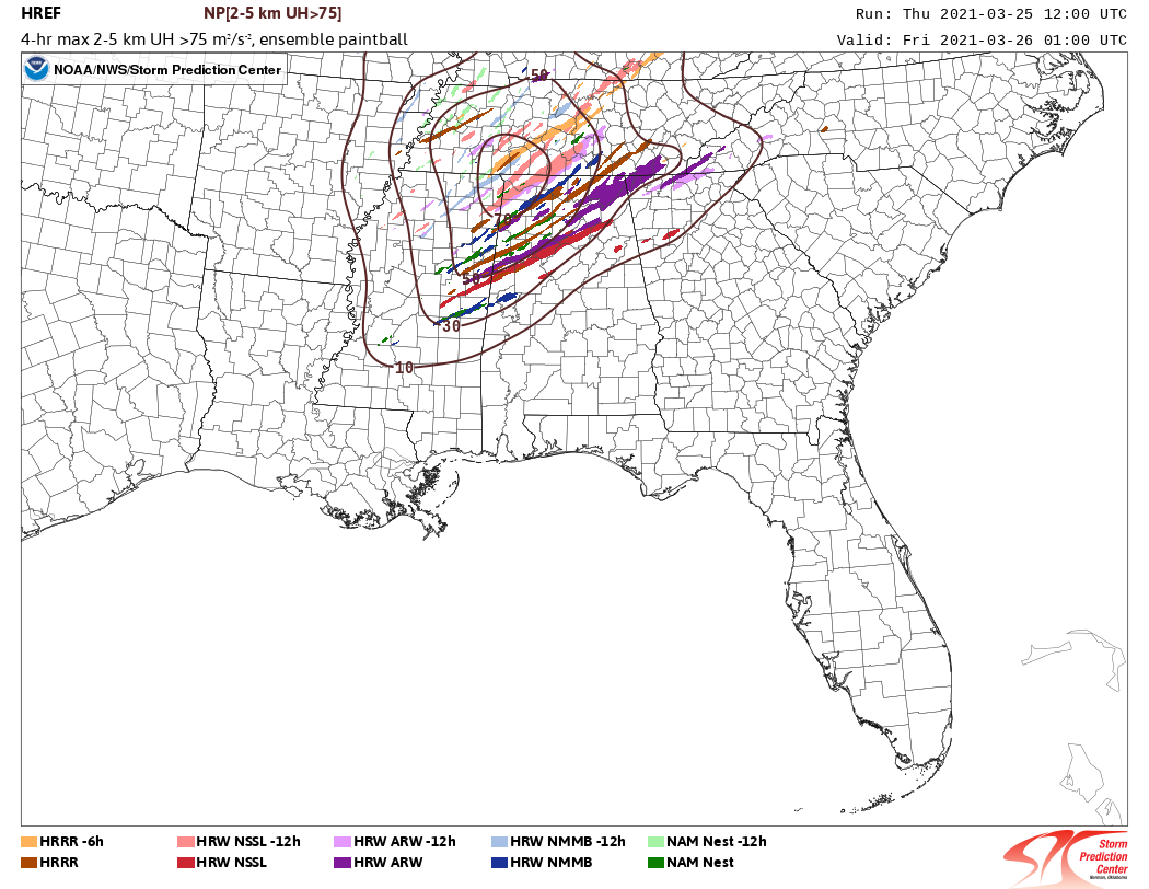
That is a concerning amount of strong helicity tracks from the 12z HREF. Some of those are very long tracked
-
 1
1
-
 2
2
-
-
1 minute ago, mob1 said:
3K NAM also looks far better (for severe potential) for northern AL/MS and well into TN. Meso models are definitely trending towards a deeper low and better moisture surge.
Its still pretty bare with deep convection in Mississippi and Alabama. Looking at some soundings in the warm sector I'm not sure why that is either. There is an EML and associated CAP in the afternoon but nothing that would hamper convection that much.
-
In typical HRRR fashion its pretty crazy in the warm sector Thursday
-
 1
1
-
-
7 minutes ago, yoda said:
Where did you find that on CIPS?
-
 2
2
-
-
You do have to wonder about the lack of a CAP Thursday and how that might allow junkvection to fire and contaminate the warm sector. Besides that, environmental parameters are off the charts. A potentially very potent setup.
-
That storm north of Brockwood had 130kts of G2G shear
-
Nasty MCS tonight across South Dakota. Several 80+ wind reports so far
-
1 hour ago, Indystorm said:
Possible svr storm watch coming for St. Louis and central IL area per SPC meso discussion.
Surprised they didn’t pull the trigger on that watch. Severe storms haven’t been hard to come by
-
Some wild velocity signatures with that cell near Post
-
Tornado on the ground north of Americus Kansas
-
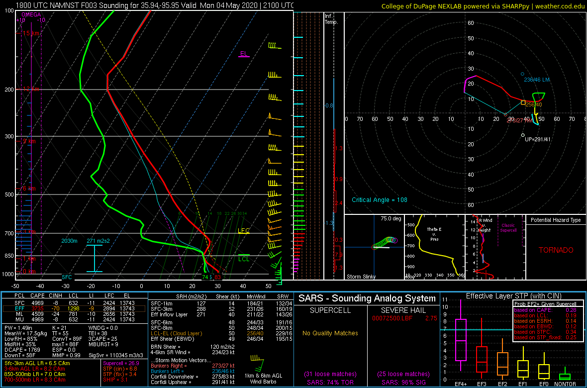
NAM has the LLJ screaming across the threat area after sunset Wednesday. Certainly going to be tons of low level shear for storms to work with. Effective bulk shear is still on the low side. Sounding near the OKC area at 03z
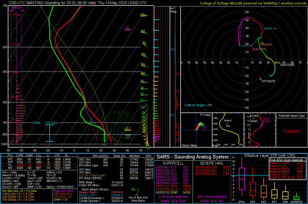
-
Hodographs for Wednesday look nasty but 3km CAPE is poor in many of the soundings I’ve been pulling. That’s something to keep an eye on as we get closer
-
1
-
-
1 hour ago, Chinook said:
I am playing around with Radarscope right now for the first time. Is there a way to save the screen as a picture?
Looks like your on the PC app. If you click the "share" button in the bottom right of the screen you should be able to save a PNG to your computer
-
1
-
-
9 hours ago, jojo762 said:
00z GFS jumped on the bandwagon for next week as well... depicts two severe days across the plains on Wednesday and Thursday. With Wednesday possibly featuring higher-end tornado potential... stay tuned!
Soundings on Wednesday look nasty across portions of Kansas and Oklahoma. Going to be a day to watch for sure
-
Wonder if this one will work out better than the last one of these I posted

-
 2
2
-
-
Wicked hook developing on that cell near Miami OK
-
8 minutes ago, Indystorm said:
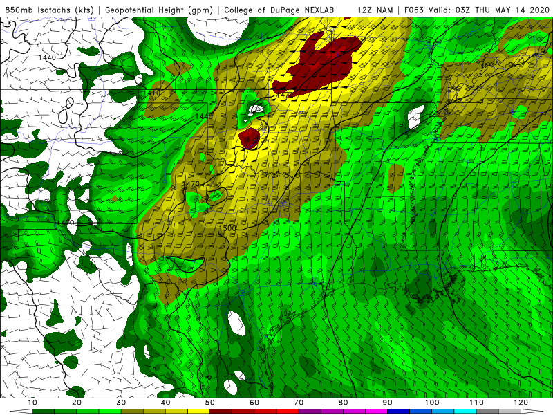
Is it the poor low level lapse rate or the 700 mb possible cap around 10 that is inhibiting convection at the moment?
Looking at some virtual sounding's id say it's the CAP around 800mb. Here's the 18z 3km NAM around Tulsa at 21z

-
18 minutes ago, Quincy said:
After tomorrow, the following seven days look very quiet and generally unfavorable for severe weather across the central states. NW flow can’t get it done this early in the season, as moisture return is usually anemic north of I-40.
With that said, it is common for a lull in activity that in early May. We just had the most active April since 2011, so it was bound to quiet down eventually. It’s rare to have an extended period of consistently active severe weather during the first half of spring.
Interestingly enough, 2011 has followed a similar tornado curve to this year. Recall that in 2011, after late April, the pattern basically shut down for two weeks. It wasn’t until mid to late May (roughly four relatively quiet weeks) that the pattern became active again.
First half of May 2011 was very quiet, then Joplin happened. All it takes is one
-
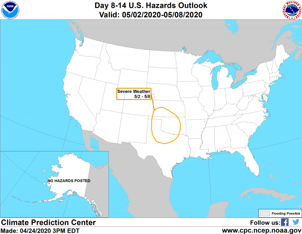
CPC highlighting the southern plains for severe weather the first week of May
-
1
-
-
The Naples storm is tightening up quickly
-
6 minutes ago, Indystorm said:
I'd watch the cells along the Red River moving southeast.
Just went tor warned. Some pretty rapid rotation on it
-
Latest run of the HRRRv4 has two areas of convection this afternoon. One in eastern OK and the other in E TX. The eastern TX storms look the most likely for tornadoes
-
Normally don't see hail cores this strong in SE Georgia. Pretty impressive
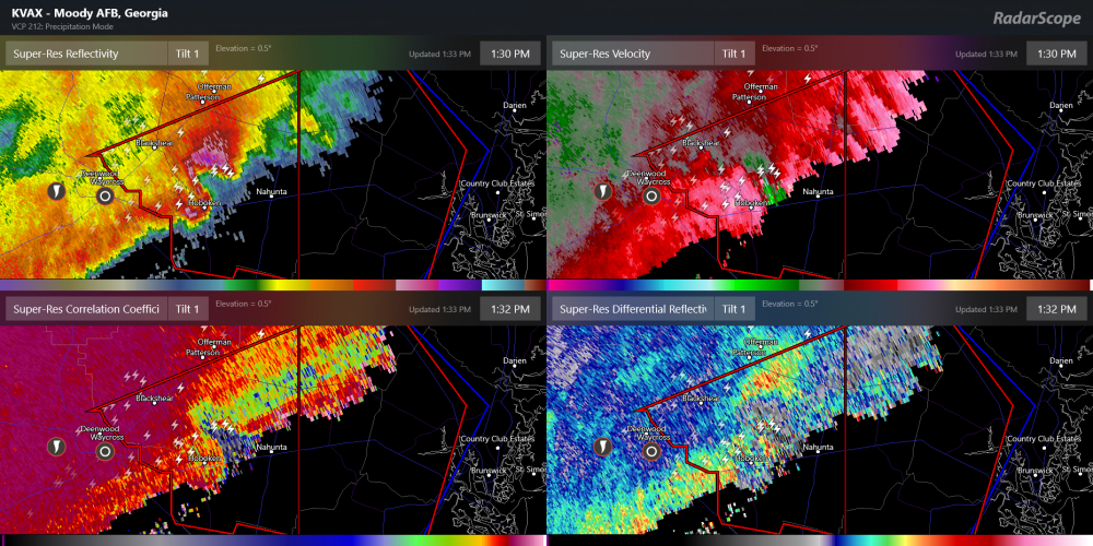


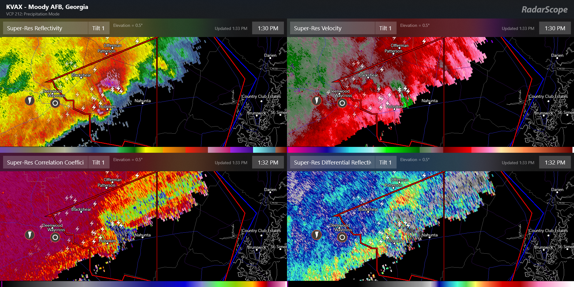
Severe Event March 25th 2021
in Southeastern States
Posted