
twistingtornado
-
Posts
30 -
Joined
-
Last visited
Content Type
Profiles
Blogs
Forums
American Weather
Media Demo
Store
Gallery
Everything posted by twistingtornado
-
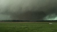
March 26-28 Severe Threat
twistingtornado replied to Tim from Springfield (IL)'s topic in Lakes/Ohio Valley
I'm more concerned with what's happening in the 1-3 km layer in the wind profiles. Namely, backing. -
March 26-28 Severe Threat
twistingtornado replied to Tim from Springfield (IL)'s topic in Lakes/Ohio Valley
Yes, PDS tornado watches can occur outside high risk. I've seen PDS tornado watches in moderate risk areas. I would be confounded if that happened today, but it's not like I'm in agreement with the SPC's products today. Definitely don't agree with their assessment of long track tornadoes from south central Missouri into Illinois. They're neglecting the wind profiles again which don't become favorable until the cells get into northeastern Missouri/Illinois. If there's a long track tornado in central to eastern Missouri, I'll eat my heart out. -
March 26-28 Severe Threat
twistingtornado replied to Tim from Springfield (IL)'s topic in Lakes/Ohio Valley
06z HRRR run has no discrete cells forming in Northern Illinois due to earlier crapvection. Compare 00z run to 06z run valid at 18z. The cap doesn't hold as a shortwave trough ejects northeast over Iowa in the late morning. Threat for northern Illinois would be nil. A messy storm mode ensues in west and central Illinois, but looks like there could be a few discrete cells that take advantage of their environment in that region. This is trending toward an enhanced risk instead of a high risk. -
March 26-28 Severe Threat
twistingtornado replied to Tim from Springfield (IL)'s topic in Lakes/Ohio Valley
18z NAM valid at 00z Sunday has the triple point southwest of 12z ECMWF, 18z GFS too quick and east as usual, and 18z HRRR is to the northeast. HRRR generally agrees with ECMWF's triple point location earlier at 18z, but has the warm front farther north and the southern portion of the cold front in Missouri southward further east. HRRR looks like it's being too quick and northeast with the system by 00z. Feels like the ECMWF is a happy medium right now, but anything can happen. Problem with Missouri being in play for tornadoes are the mainly linear hodographs. Doesn't mean there can't be tornadoes, but makes the storm mode messy with storm split interactions. I've even seen some forecast hodographs in northeast Missouri and southeast Iowa with a s-shaped wind profile in the 0-2 km layer. Those locations are in the 10% hatched for tornadoes, but I'm not all that confident about that. Waiting on the 00z updates now.
