-
Posts
30 -
Joined
-
Last visited
Content Type
Profiles
Blogs
Forums
American Weather
Media Demo
Store
Gallery
Everything posted by twistingtornado
-
Severe Event March 25th 2021
twistingtornado replied to Bob's Burgers's topic in Southeastern States
Looks like the tornado significantly weakened or lifted before hitting Wilsonville. -
March 17-18 Severe Weather Event
twistingtornado replied to DanLarsen34's topic in Southeastern States
A large concern with this setup is the potential for wedge tornadoes overnight in a region notorious for after-dark tornado outbreaks. As the evening wanes and the nocturnal LLJ ramps up, this setup is screaming danger in the 0-1 km layer over Alabama. Textbook long/looping hodographs, shear vectors with a large magnitude component normal to the front, and extremely low LCL heights. Not what you want to see at any time, let alone 12-4 am. These rain wrapped wedges may be hard to make out during the day, let alone at night. Nobody should attempt to confirm these. Was going to post this last night, I'll post it now that some skeptics have showed up before the nocturnal LLJ has fully ramped up. -
Severe Weather 3/12-3/15
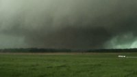
twistingtornado replied to Tallis Rockwell's topic in Central/Western States
Impressive supercell cycling, going from one intense circulation to the next (which was really two circulations). Glad to hear it was in a rural area, hopefully nobody got hurt. 28969709-d90d-444c-98d3-5b01b0fc1226.mp4 -
-
Strong tornado? With those wind profiles? Yeah, good luck. They're a lot worse than the forecasted wind profiles. Less aircraft observations looks like it definitely had an impact on forecasting this event.
-
-
-
-
-
-
Rain-wrapped tornadoes at 4:30 am, not ideal.
-
-
-
It can be quite tricky to get warnings out in time with all these brief spin up tornadoes in a QLCS. Not uncommon to put the wording for possible tornado into the severe thunderstorm warning, which is what I believe they did here.
-
They're right on the cold front, so no.
-
It would have to take the mother of all right turns to get to Macon, which isn't going to happen. It will stay well north of Macon. Looks like it's weakening anyway.
-
-
Ah, I see now. It's earlier than the data I'm looking at. Looked like a very brief spin up.
-
There's no TDS. No couplet either.
-
Picture of that tornado reminds me a ton of the Hackleburg/Phil Campbell tornado on 4/27/2011.
-
The 06/07/08z HRRR runs have a cluster of supercells forming over western Mississippi by 21z that track into northern Alabama. NWS in Huntsville is describing the HRRR as an outlier in how far north it lifts the warm front- most models lift the warm front through at least northeastern AL, while HRRR is lifting the warm front north of the AL/TN border. That'd be the worst case scenario for northern AL, but at least it's an outlier. Warm front is still one thing to keep an eye on when looking at observations today.
-
Correlation coefficient shows that it's rain wrapping around the RFD, not a debris ball. So not a TDS. Radar station is to the NE, so the velocity signature in the screenshot I posted isn't as impressive as it may appear to the untrained eye. Can say the velocity signature has been all over the place in the past 15-20 min.
-
March 26-28 Severe Threat
twistingtornado replied to Tim from Springfield (IL)'s topic in Lakes/Ohio Valley
SPC has baffled me all day, and then this. I don't know how they expect to get the greatest short-term threat for tornadoes out of elevated convection in southern Wisconsin. -
March 26-28 Severe Threat
twistingtornado replied to Tim from Springfield (IL)'s topic in Lakes/Ohio Valley
Looks like that supercell that previously had a radar confirmed tornado in AR has recycled and the circulation has tightened up. And yup tornado warned, radar indicated currently. Jonesboro is included in this tornado warning. I'd take this one very seriously. -
March 26-28 Severe Threat
twistingtornado replied to Tim from Springfield (IL)'s topic in Lakes/Ohio Valley
Wasn't talking about Iowa, was talking about the area highlighted for long track tornadoes in Missouri in Mesoscale Discussion 250. Currently isn't in a watch.
