

Ahoff
-
Posts
2,652 -
Joined
-
Last visited
Content Type
Profiles
Blogs
Forums
American Weather
Media Demo
Store
Gallery
Posts posted by Ahoff
-
-
17 minutes ago, ChalkHillSnowNut said:
What were the monthly averages in April and May? Were they above or below normal? I know Jan and Feb were pretty much lower right?
April above, May slightly lower essentially average.
-
 1
1
-
-
2 hours ago, TheClimateChanger said:
Made it to 92 so far today. With clouds & scattered thundershowers, that’s probably as high as it will get today.
Did a surge to 93. Might be the high today. With rain coming, I don't think that 74 degree low holds.
-
 1
1
-
-
34 minutes ago, TimB said:
First time since 1885, 1887 and 1888 that Pittsburgh has gotten to 94 in 3 out of 4 consecutive Junes.
Interestingly, those June's lately have outperformed July and August with peak temperatures (last year all three hit 94, but still). June has generally outperformed August these last few years. More front loaded summers it seems.
-
Yep, temps were forecasted pretty well, maybe a hair under, but not as off as last year’s June heat. Dew points seemed lower than forecast as well, if only by a little. Still very hot out there, but more Heat advisory than Extreme Heat warning.
-
Might have stopped at 93 again. Which is a bit surprising considering we ran ahead of yesterday most of today. Might still sneak a 94 in the inter obs.
-
The temps so far are pretty much spot on. Looks like 93 so far today per the 5 minute obs.
-
First official 90 degree day. 92 so far.
-
Nice and cloudy out there.
-
If dew points are overdone, that could feasible let the temps rise a little higher, though I’d still say it tops at 94 max.
-
The NWS discussion does mention that with such high dew points mid 90s is usually tough, but still says the chance of over 95 is >60%
-
13 minutes ago, TheClimateChanger said:
It will be interesting to see where June 2025 stacks up when all is said and done. The Accuweather forecast for Carnot-Moon, PA for the rest of the month would imply the final mean temperature would come in around 73.3F. That would be the hottest June recorded at the airport, and the hottest in the threaded record since 1943. While it would only tie for 10th hottest in the threaded record, it would be 4th hottest since 1898. Six of the top 10 are during Pittsburgh's temperature steroid era of the late 1800s. Last June finished at 72.8F and was the warmest since 1994 & 3rd warmest overall at the airport behind 1967 & 1994. As an aside, if you search "Pittsburgh International Airport" on Accuweather, it actually generates the forecast for Pittsburgh Central Business District instead of Carnot-Moon or Findlay Township. So I didn't use those higher figures [that forecast would imply a final mean checking in at a whopping 73.8F!].
With that said, I do suspect the Accuweather forecast is a little overdone and would favor a final mean temperature around that of last June.
I agree. I don't think we'll see 96 during this event. I'd say we top out at 94 maybe Monday and/or Tuesday, and lower 90s the rest of the time. However the Carnot-Moon Accuweather point and click did tick a bit warmer this morning, lol.
-
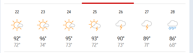
Accuweather for the Carnot-Moon area.
-
 1
1
-
-
7 hours ago, TheClimateChanger said:
With the very warm lows, could be one of the hotter 4-day stretches in the month of June by mean temperature.
These are the 10 highest 4-day mean temperatures in the threaded history. Last year's heat, while falling short of the early 99-101F type forecasts, was still one of the hottest 4-day stretches on record for June. 8th officially, but several of those are duplicates from heat waves that lasted more than 4 days, such that only 4 different years saw hotter 4-day means.

I am hesitant to believe the mid 90s that are being forecast, especially after last year's bust. We do typically fall short, and with the amount of moisture in the ground it will be hard to get that high. However, I do think we'll get a few 90 degree days out of this. The humidity will be brutal.
-
If NWS is correct for Monday and Tuesday, we’d be flirting with record highs both days. They’re forecasting 94 both days, records are 95 and 96.
-
7 hours ago, TheClimateChanger said:
Upper 80s on tap for today. Should be the hottest of 2025, so far. The warmest reading observed this year at KPIT is 86F, on June 4th and on April 19th.
As usual for summer, KPIT fell short of expectations. 85 so far.
-
So, is this Canadian wildfire smoke coming in to ruin the next few dry days, with muted sunshine and cooler than forecast temps or is it supposed to miss us? I've seen both forecasts.
-
It's summer, I guess.
-
The warmth for the month has been wiped out. We should end below normal for May.
-
1
-
-
21 hours ago, ChalkHillSnowNut said:
I’m down with nice and cool/enjoy it while we can while the Antarctic ice finally grew for the first time in a decade
That's nice in Fall and Winter, lol.
-
Looks absolutely horrible this week. What a way to ring in the start of summer.
-
 1
1
-
-
Looks like a crappy Memorial Day weekend, unfortunately, but hopefully we turn a corner and get drier, warmer weather after.
-
 1
1
-
-
Never lost power in the southern part of the City. My 20 minute drive to work looked like nothing happened, which is weird. Most places in the South Hills had no power and tons of damage. Work actually lost power at 10:30 this morning and went home to work the rest of the day. Weird.
-
Third strongest wind gust recorded at KPIT. 71.3 mph
-
Power went off briefly twice. Back up.
Pittsburgh Summer? 2025
in Upstate New York/Pennsylvania
Posted
I believe this. It has been terribly humid.