

SnowGiant611
-
Posts
61 -
Joined
-
Last visited
Content Type
Profiles
Blogs
Forums
American Weather
Media Demo
Store
Gallery
Everything posted by SnowGiant611
-
Let's refresh the snowpack and do Christmas right. Let's just pray there are no cutters in our future as that would be disastrous with this snow...especially on roofs in the area.
-
What a wild radar signature there. Look at the shear displayed here? The instability must have been WAY higher than modeled/projected. Did anyone trend CAPE rates at the onset and transitioning to the height of the storm?
-
I live in Bow, NH, but I am currently in Gilmanton, about 15 min from dendy in Northfield.
-
Haven't posted after being stuck in the driveway for 3 hours and taking an hour to get somewhere it should have taken me 15min. Everyone is off the road...cars stuck everywhere. Absolutely WHITEOUT conditions up here...you can't even see 5 feet in front of you. Snowfall totals: A wicked lot of snow. What a truly historic, impressive storm. This reminds me of the great Norlun trough event of like 10 years ago where it snowed for 48 hours straight. I'll try to get measurements soon.
-
ALB look like that town in that movie THE FOG on radar. That band in SNH/CNH seems to be increasing in coverage and intensity...
-
Looks like the secondary starting to spin up near DC. Is this further W than forecast? We were expecting this to develop near the DELMARVA, no?
-
19/0 in Gilmanton, NH Dewpoint has come up 2 degrees since last post, but temp has dropped 4 degrees. Would like to see a bit more movement on dewpoint here... That development of a leading band in SNH banking NE seems an interesting development, however.
-
23/-2 here in Gilmanton, NH. That below zero dewpoint is likely what kills us up here...unless we get into mid-level forcing or banding, the column will likely be very slow to saturate here.
-

Active mid December with multiple event potential
SnowGiant611 replied to Typhoon Tip's topic in New England
Talk about waffling, Mark, lol. Not feeling very good about our chances for warning snows up here. Your thoughts? -
Active mid December with multiple event potential
SnowGiant611 replied to Typhoon Tip's topic in New England
Keep an eye on Binghamton and Utica, NY. How quickly the column saturates there and echoes start reaching the ground might be a clue to how the precip is able to battle the dry air at lower levels in the northern periphery of the precip shield. Additionally, it will be interesting to see how far the shield advances into CNY/UNY prior to be shunted east by the confluence to the N. -
Active mid December with multiple event potential
SnowGiant611 replied to Typhoon Tip's topic in New England
Good morning, all! Seems the models have ticked S? I’m no longer in a prime zone and seem to be fighting for .5 QPF? Who can summarize the latest trends? -
Active mid December with multiple event potential
SnowGiant611 replied to Typhoon Tip's topic in New England
The model spreads are very interesting, but it does seem like we have pretty solid trends. Looks like the forecast of the hard cutoff on the northern periphery was possibly incorrect, at least for CNE. The best mid-level forcing is still TBD, but it remains to be seen if this storm will over-perform or not. I just don’t feel we can squeeze this much QPF in a progressive flow with little or no upstream blocking when the SLP barely breaks 1000mb? -
Active mid December with multiple event potential
SnowGiant611 replied to Typhoon Tip's topic in New England
A guy can dream... -
Active mid December with multiple event potential
SnowGiant611 replied to Typhoon Tip's topic in New England
That is insane. Incredible how far we’ve come in < 24 hours! I went from a c-1” to a potential jack. -
Active mid December with multiple event potential
SnowGiant611 replied to Typhoon Tip's topic in New England
Thunder... Thunder... Thunder... Thundersnow...HO!!! Who gets it? -
Active mid December with multiple event potential
SnowGiant611 replied to Typhoon Tip's topic in New England
If this verifies, what a difference 24 hrs makes for CNE... -
Active mid December with multiple event potential
SnowGiant611 replied to Typhoon Tip's topic in New England
GFS critical thickness @hr 48 (18z). Classic CF signature?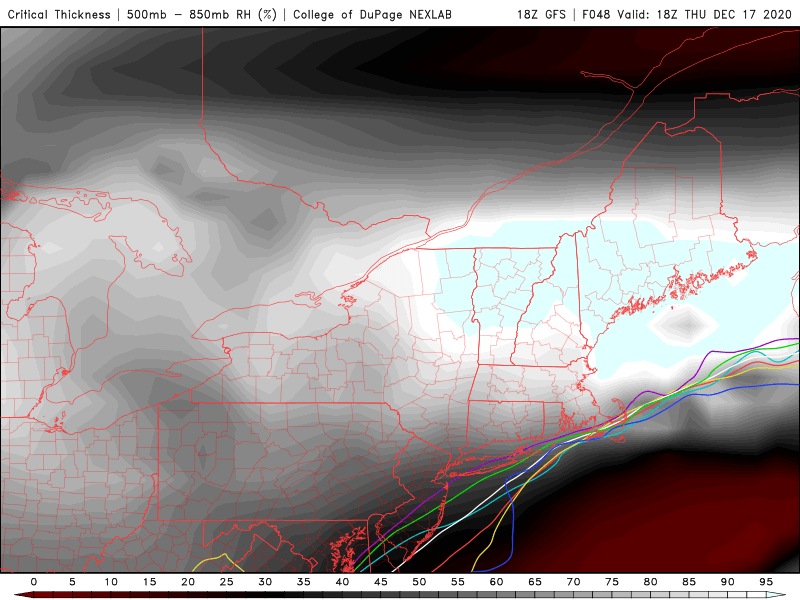
-
Active mid December with multiple event potential
SnowGiant611 replied to Typhoon Tip's topic in New England
LOL, I decide to pop in and share in the (short-lived) excitement for my area. My only hope is for that CF to push deeper inland off the NH seacoast and I end up in the band just NW or so from there by about 20-30 mi. I think if we see 2-4" of snow up here, we will be lucky. Don't think we are going to see the best lift/forcing and with the fluff factor we will be 15:1 or even higher, maybe, so it won't take much precip to pile up the totals, but as far as impressive...eh. -
Active mid December with multiple event potential
SnowGiant611 replied to Typhoon Tip's topic in New England
How important is the initial position of cyclogenesis off the EC to the eventual verification of the models? Will the LP simply be shunted directly OTS once it hits the HP confluence just south of central LI? Will it be rapidly pushed E or will it linger/occlude? -
Active mid December with multiple event potential
SnowGiant611 replied to Typhoon Tip's topic in New England
So why the N bumps at this time? Is the HP in CA not as strong as forecasted? Is the LP stronger? Educate the unwashed masses here, haha! -
Active mid December with multiple event potential
SnowGiant611 replied to Typhoon Tip's topic in New England
Given as how traditionally the best snows are usually along and just NW of the H5 low track, can anyone provide an ensemble showing this mean evolution over time? Might help to visualize the model trends as well as provide more tightly clustered guidance where the CF may actually set up. If we get a CH torch off the NH seacoast, the CF should make it midway through Rockingham county and then I am definitely in business here. -
Active mid December with multiple event potential
SnowGiant611 replied to Typhoon Tip's topic in New England
Anyone else surprised that we don't have more of a baroclinic zone setup here? With the tight pressure gradients I would expect to see more wind than being forecast? Is this due to lack of mixing to the lower levels? Could this actually be a sneaky factor for snow accumulations for northern zones? If the NE wind was stronger, this would support even more colder air funneling down from Canada? -
Active mid December with multiple event potential
SnowGiant611 replied to Typhoon Tip's topic in New England
I just have this strong feeling that the radar is going to be showing amazing returns over our location, but due to the dry air in place nothing will reach the ground. These models often have a very difficult time forecasting erosion of the leading edge of the precip shield. Also, if it takes 5-6 hours to saturate the column up here, we lose opportunity for the biggest snows, especially if the storm rotates OTS quickly as opposed to a N/NE motion into the Gulf of Maine. -
Active mid December with multiple event potential
SnowGiant611 replied to Typhoon Tip's topic in New England
Well, I've mostly been sitting this out up here near the Lakes Region. Are we now back in play or is this just the typical model waffling before we get into the HR range?


