

Prismshine Productions
-
Posts
1,472 -
Joined
-
Last visited
Content Type
Profiles
Blogs
Forums
American Weather
Media Demo
Store
Gallery
Posts posted by Prismshine Productions
-
-
999.8mb
Sent from my LGL322DL using Tapatalk -
Yeah man, borderline Cat 2 winds ~4800ft above the surfaceDefinitely making an attempt at a formative eyewall this hour. Wrapping some convection to the NW side of the circulation. Some pretty significant wind reports from the keys indicate it would not take a terrible amount of intensification for this to briefly become a minimal cane. Definitely would have the half-a-cane look though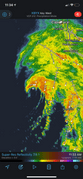
Sent from my LGL322DL using Tapatalk
-
Recon en route
Also, she trying her damnest to go Gulf Cane
Sent from my LGL322DL using Tapatalk -
No ETA given
I would make a joke here, but it would be a year late
Sent from my LGL322DL using Tapatalk
-
 1
1
-
-
Well that sure was nice of them...Serious answer, the Cuban government gave the US Air Force and Hurricane Hunters permission to enter Cuban airspace for hurricane purposes a while ago.
Sent from my LGL322DL using Tapatalk
-
Recon heading to Elsa, did they get clearance to fly in Cuban airspace?
Sent from my LGL322DL using Tapatalk -
I know man, but that should have been flaggedIt’s unflagged but bad data.
Sent from my LGL322DL using Tapatalk
-
1
-
-
That is the recon data, they found an unflagged (uncontaminated) 105kt surface gustWhat do those numbers mean?
Sent from my LGL322DL using Tapatalk
-
What in the helllllll...

Sent from my LGL322DL using Tapatalk -
Laura last year?Cuban radar page will be very useful for tracking Elsa over the next day http://www.insmet.cu/asp/genesis.asp?TB0=PLANTILLAS&TB1=RADARES
Elsa deserves some sort of medal for threading the needle 100%. It really missed all the landmasses in the Greater Antilles. Radar shows its off to the west of the Cuban mountains now.
Anyone remember a storm threading the needle like this? I sure don't.
Sent from my LGL322DL using Tapatalk
-
Anyone else buying the NW movement on the 2pm advisory?
Sent from my LGL322DL using Tapatalk -
1011mb, how much more before she opens into a trough...
Sent from my LGL322DL using Tapatalk-
1
-
-
Recon finds a 1005mb center at the bottom left of that convection bubble
Sent from my LGL322DL using Tapatalk -
Recon about to enter Elsa
Sent from my LGL322DL using Tapatalk-
1
-
-
Is Elsa about to do some incredibly stupid crap where a new LLC stacks under the convection? Seen that dance quite a few times the last few years...
-
29 minutes ago, CaryWx said:
That might be overdone
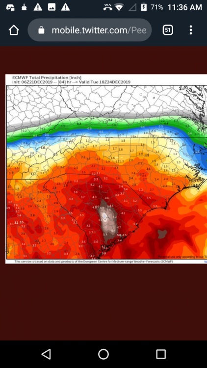
Underdone... 6z Euro:
-
6 minutes ago, superjames1992 said:
That really isn't a LP track we want to see outside the mountains. We want it more offshore. Running inland isn't going to work.
And that it's November and not mid-January certainly doesn't do us any favors, either.
Yet for November, still an appetizer... Models are still bouncing around the LP, so it should still could shunt further offshore IF the high stays a bit longer
-
5 hours ago, JoshM said:
Euro gives most of NC a little love.
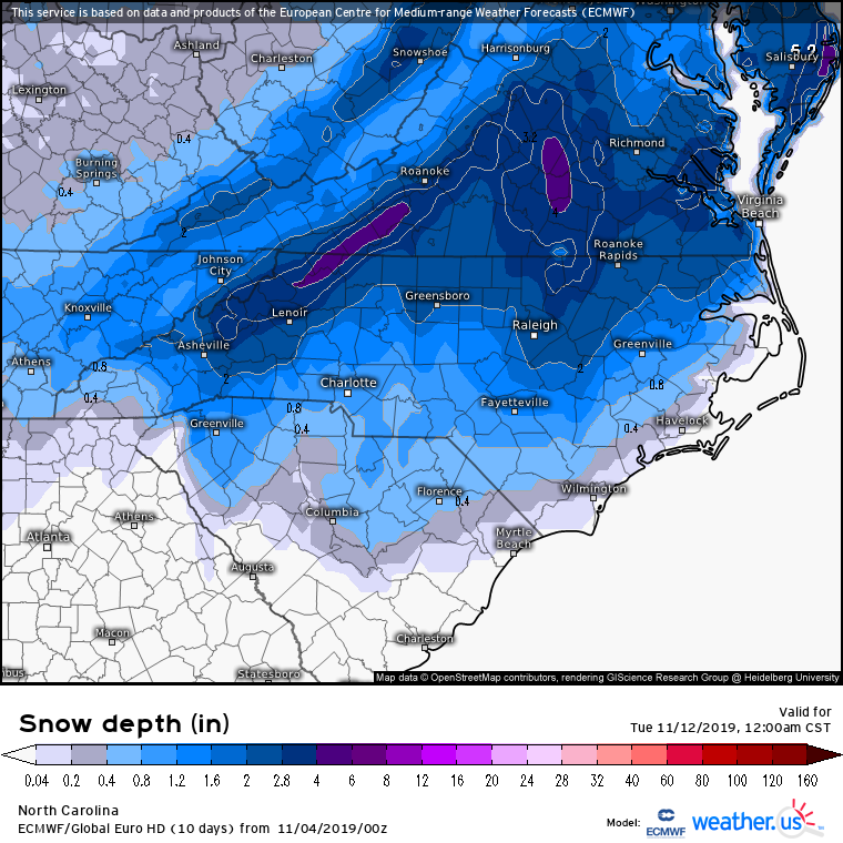
South Carolina Midlands too, bust the CAE Snow Shield...
-
34 minutes ago, Floydbuster said:
Cute little cane.
From @HurricaneJosh's Twitter (love the term by the way Josh!)
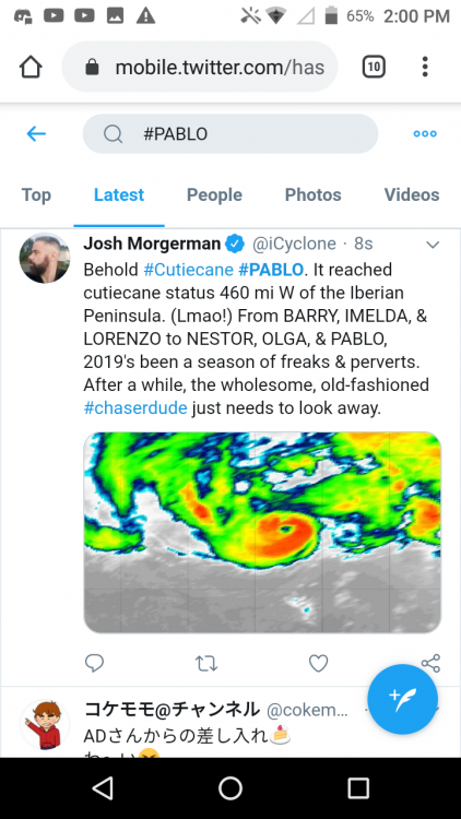
-
056
WTNT43 KNHC 271450
TCDAT3

Hurricane Pablo Discussion Number   8
NWS National Hurricane Center Miami FL       AL182019
1100 AM AST Sun Oct 27 2019

Satellite imagery shows that Pablo has continued to maintain a
small eye, and that the eyewall cloud tops have recently cooled.
In addition, early morning microwave satellite intensity estimates,
as well as the CIMSS satellite consensus, indicate that Pablo has
become a hurricane.  The initial intensity is increased to 65 kt as
a blend between the subjective estimate from TAFB and the higher
SATCON estimate, and it is possible this is a little conservative.
The intensification has occurred while Pablo is over sea surface
temperatures of 19-20C, and it is likely that cold mid- to
upper-level air temperatures have allowed the cyclone to maintain
deep convection and strengthen over water temperatures where
tropical cyclones normally weaken.

The initial motion is now 030/28.  The cyclone is expected to turn
northward and slow its forward motion as it approaches a frontal
system to the north during the next 12-24 h, and this will be
followed by a turn toward the northwest as a large mid-latitude low
over the north central Atlantic becomes the main steering mechanism.
The track guidance has again shifted a little to the east, and the
new forecast track is also nudged a little to the east of the
previous track.  Like the previous forecast, it lies close to the
various consensus models.

Pablo should encounter even colder water along the forecast track,
and global model guidance suggests it should merge with the frontal
system between 12-24 h.  This combination should cause Pablo to
weaken and become an extratropical cyclone.  Thereafter, the system
should be absorbed by the much larger low to its west between 48-72
h.


FORECAST POSITIONS AND MAX WINDS

INIT  27/1500Z 42.8N  18.3W   65 KT  75 MPH
 12H  28/0000Z 45.3N  17.2W   55 KT  65 MPH
 24H  28/1200Z 46.9N  17.8W   50 KT  60 MPH...POST-TROP/EXTRATROP
 36H  29/0000Z 47.9N  18.7W   45 KT  50 MPH...POST-TROP/EXTRATROP
 48H  29/1200Z 49.5N  20.3W   40 KT  45 MPH...POST-TROP/EXTRATROP
 72H  30/1200Z...DISSIPATED

$$
Forecaster Beven
-
Pablo now a hurricane
11:00 AM AST Sun Oct 27
Location: 42.8°N 18.3°W
Moving: NNE at 32 mph
Min pressure: 983 mb
Max sustained: 75 mph


Hurricane Elsa
in Tropical Headquarters
Posted
One of the creepiest radar images I have ever seen...
Sent from my LGL322DL using Tapatalk