

pen_artist
-
Posts
41 -
Joined
-
Last visited
Content Type
Profiles
Blogs
Forums
American Weather
Media Demo
Store
Gallery
Posts posted by pen_artist
-
-
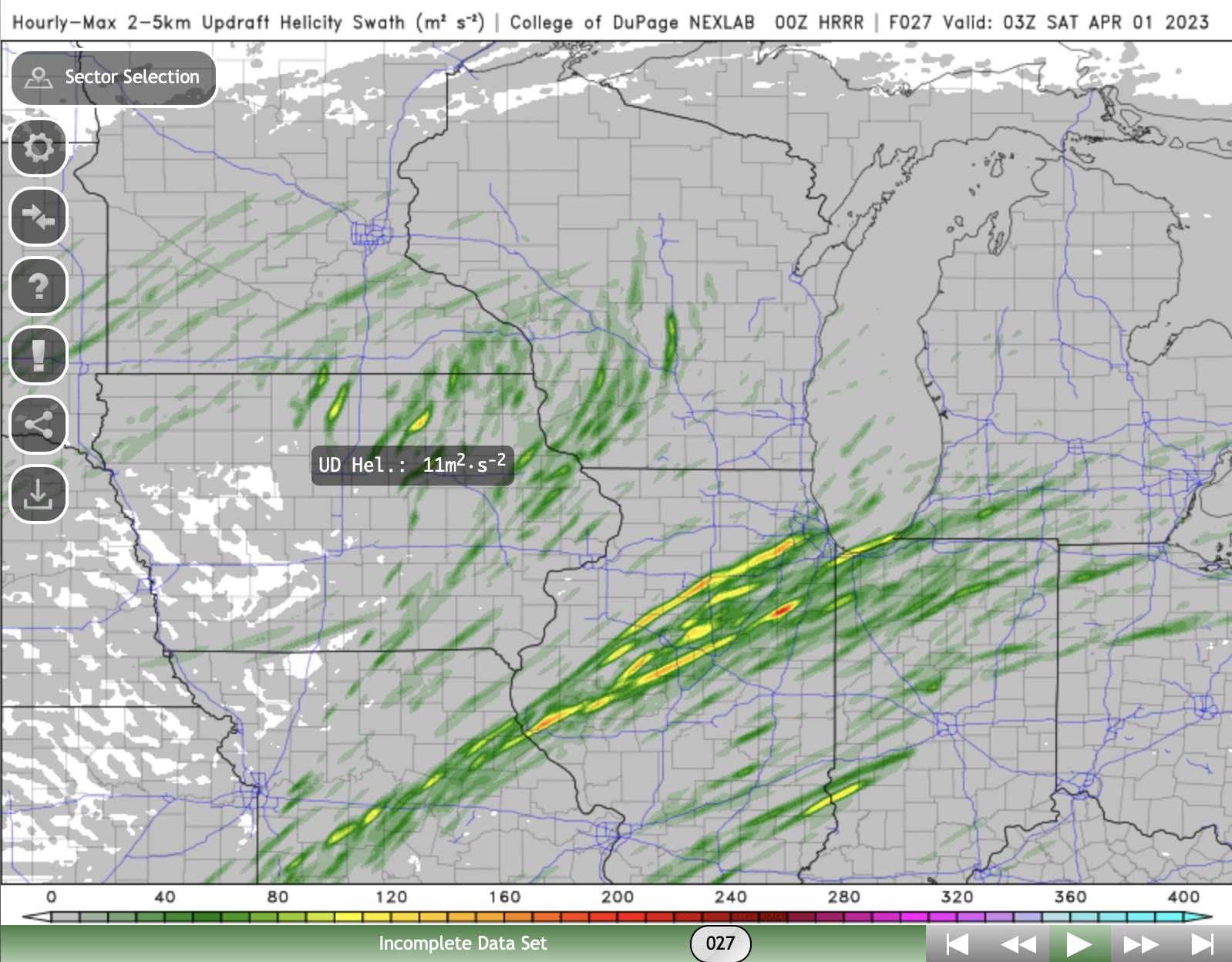
Most recent HRRR run (20z) returning to showing some discrete cells in Chicagoland between 6PM-11PM.
-
 1
1
-
-
Thought I would get a thread started. Models looking relatively consistent today for an event early next week in Great Lakes region.
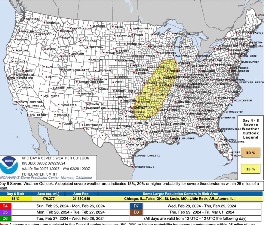
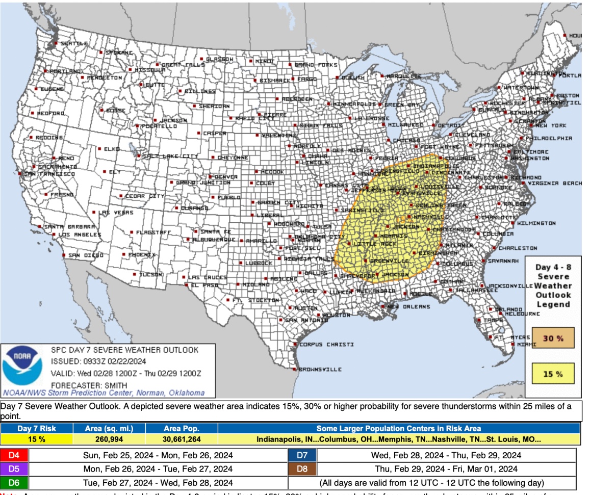
Day 6
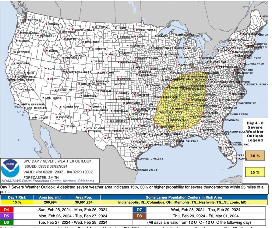
Day 7
-
 1
1
-
-
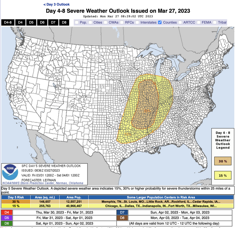
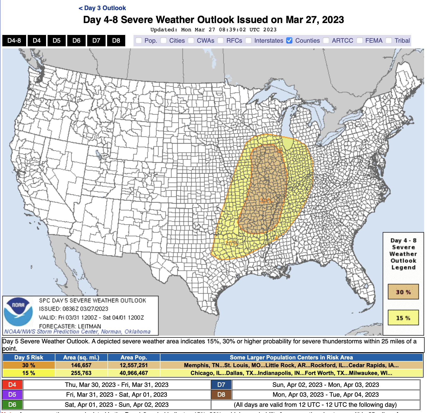
Thought I would go ahead and get a thread started for what is looking to be a more consistent signal for an subform wide severe weather event this coming weekend.
Day 4-5 discussion:
A rather potent mid/upper shortwave trough for this time of year
   will develop eastward from the Mid/Upper MS Valley to the
   Northeast/Mid-Atlantic vicinity Sunday and Monday. At the surface, a
   deepening low will move across IA and WI/MI on Sunday, before
   lifting east/northeast across Ontario and Quebec on Monday. A
   trailing cold front will sweep across the Midwest and likely be
   approaching the I-95 corridor by Tuesday morning. Enhanced midlevel
   southwesterly flow associated with upper trough atop a very
   moist/unstable boundary layer will set the stage for a multi-day
   severe weather episode ahead of the eastward-advancing cold front.

   All severe hazards appear possible on Sunday from portions of
   eastern IA through southern WI/MI into much of IL/IN, northern KY,
   and western OH, as a linear convective system moves east across the
   region. Tornado potential likely will be focused closer to the
   surface low track, and along a warm front extending from the low
   east/southeast across parts of southern WI/MI into northern IL/IN.

   The system will continue east on Monday, impacting portions of the
   upper OH Valley/Lower Great Lakes/central Appalachians vicinity. The
   surface low will be shifting further northeast into Canada.
   Nevertheless, large-scale ascent associated with the upper trough,
   and moderate vertical shear atop very moist and unstable boundary
   layer will continue to support severe convection ahead of the
   eastward advancing cold front. Damaging winds will likely be the
   greatest concern on Monday.
-
1
-
-
Looks to be some initiation occurring west of Madison now. Looking to be the first start of something breaking through the cap regionally.
-
1
-
-
Just got a decent hail storm here. Some penny to marble sized hail. Although this hasn't been the *ideal* spring pattern with some cold shots (and as others have mentioned this has been a relatively on par spring for the Great Lakes) recently, it has been relatively active svr wise IMBY compared to recent springs.
-
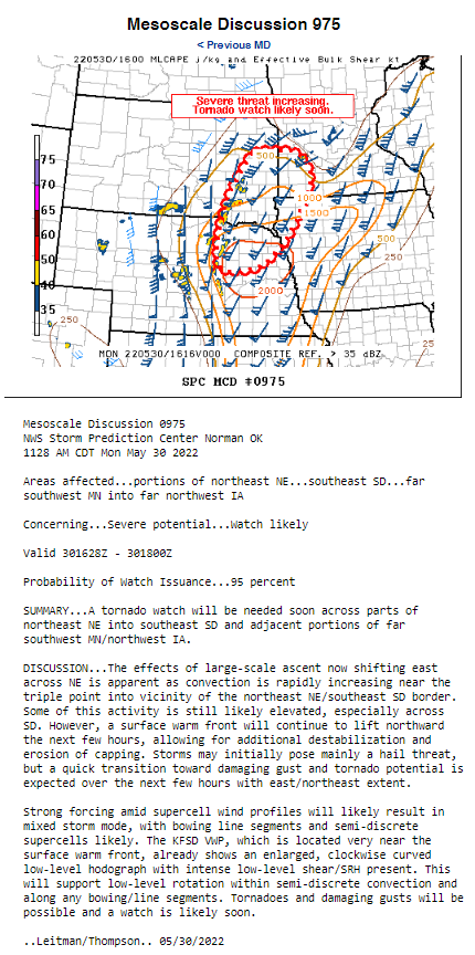
Tornado watch out now for Chicagoland into NW Indiana and Southern Wisconsin until 10 CDT. Don't know probs yet but will update on that.
-
Agreed, is crazy to see some counties in Northern Iowa in both WWA and the PDS watch.
-
Is anyone able to get an image of this outlook on a county level for N IL?
-
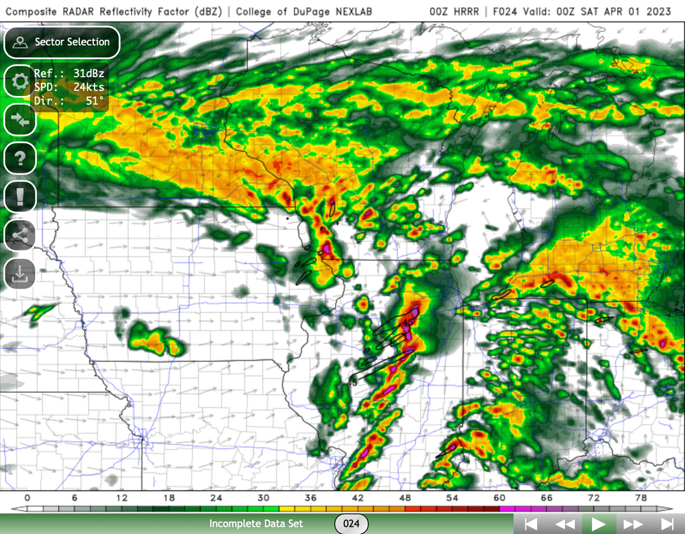
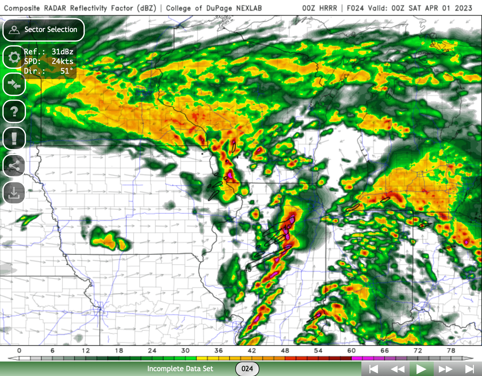
00z HRRR showing pretty quick recovery after first round of cells move through C IL. Has a 2nd round of more intense moving through the heart of the metro between 6-9pm.
-
Not to put too much stock into it (and this is more so my compensation for not having as deep of a knowledge in meteorology) but the end of the 0z HRRR has STP values ranging from 6-12 over much the Chicagoland area.
-
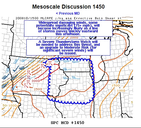
Haven't looked much into the setup myself but have heard some rumblings of a bigger severe threat later this week for western chunk of the subforum. Thought I'd get a thread going for it since it is looking like something will shape up.
-
1
-
-
In SW Plainfield just had some pea/dime sized hail. Seems like every storm passing over is producing a bit of hail with it. Odd with it being upper 40's out and having it hail but feeling like spring now lol.
-
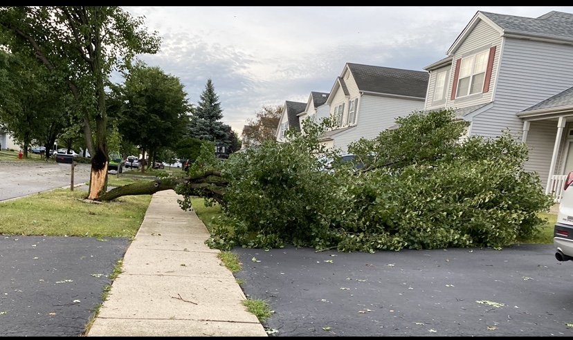
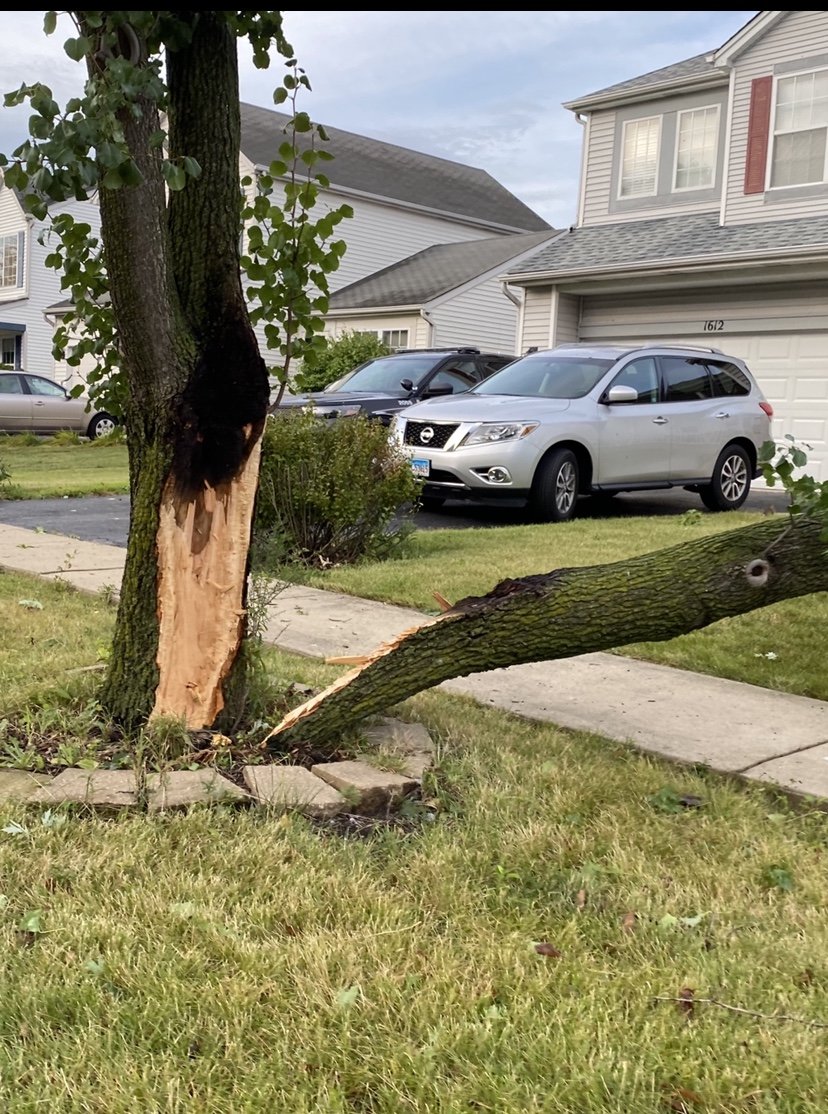
Tornado in Shorewood/Plainfield hit about 2 miles west of me. Nothing to note at my residence besides small branches and a shingle or two. Had a chance to drive through the affected neighborhood and saw a lot of blown down fences. Some siding/gutters ripped and some bigger trees uprooted (most likely due to the already soaked ground). No warning and not what I was expecting today!
-
Tornado watch incoming
-
Sun peaking through and can really feel the humidity in the house now. Looking at the visible radar it is pretty neat to see the distinct movement of the clouds as you go higher up. Got the ones above going NNE and ones below NNW. Guess we'll see what happens!
-
Welp, we got our slight risk, just couple hundred miles down south

-
 1
1
-
-
One of those rare moments weather wise I'm kind of wishing I was back on campus at Purdue but even now sitting not too bad near I-80 and I-55 corridor. Hoping for a good 8-10 inches but may be wishful thinking.
-
Puking snow right now at LAF looking like around an inch in the past hour or 2
-
Going to push my luck but thinking Purdue (West Lafayette, IN) gets 6-7" from this
-
1
-
-
pretty much sums up this event. a little near a week past and still impressive to think about

-
1
-
1
-
-
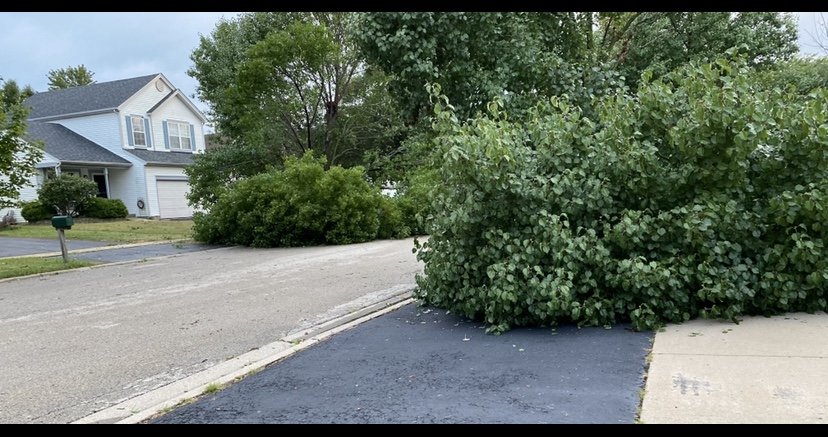
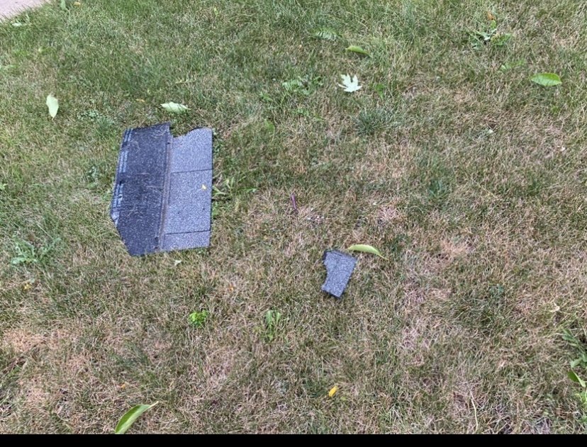
insane storm was actually at the dentist when it rolled through so they relocated me during my filling to the basement
on a walk this evening took some damage pics from around my neighborhood

-
3
-
2
-
-
Mod risk incoming
-
Got narrowly missed by like a mile at my house from some storms but suspect ill get some rain tomorrow. Still abnormally dry here but we will see how long that holds up for
-
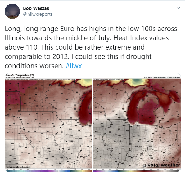
Honestly not sure what qualifies as its own separate topic discussion so please mods just let me know if this should just stay being covered in the monthly discussion threads. Figured since we may be heading toward an extended streak of dry, hot conditions that haven't been seen in quite some years a thread might be warranted.
https://twitter.com/nilwxreports/status/1280121654870339586?s=20
-
1
-
 1
1
-


4/25-4/28 Severe and Heavy Rain Threat
in Lakes/Ohio Valley
Posted
Curious what the 00z HRRR will show. 18z HRR showing around 18z Saturday a bit more of a decent environment entering into N IL/S WI. Has anyone had any thoughts on this threat for Chicago area?