crossbowftw3
-
Posts
1,401 -
Joined
-
Last visited
About crossbowftw3

-
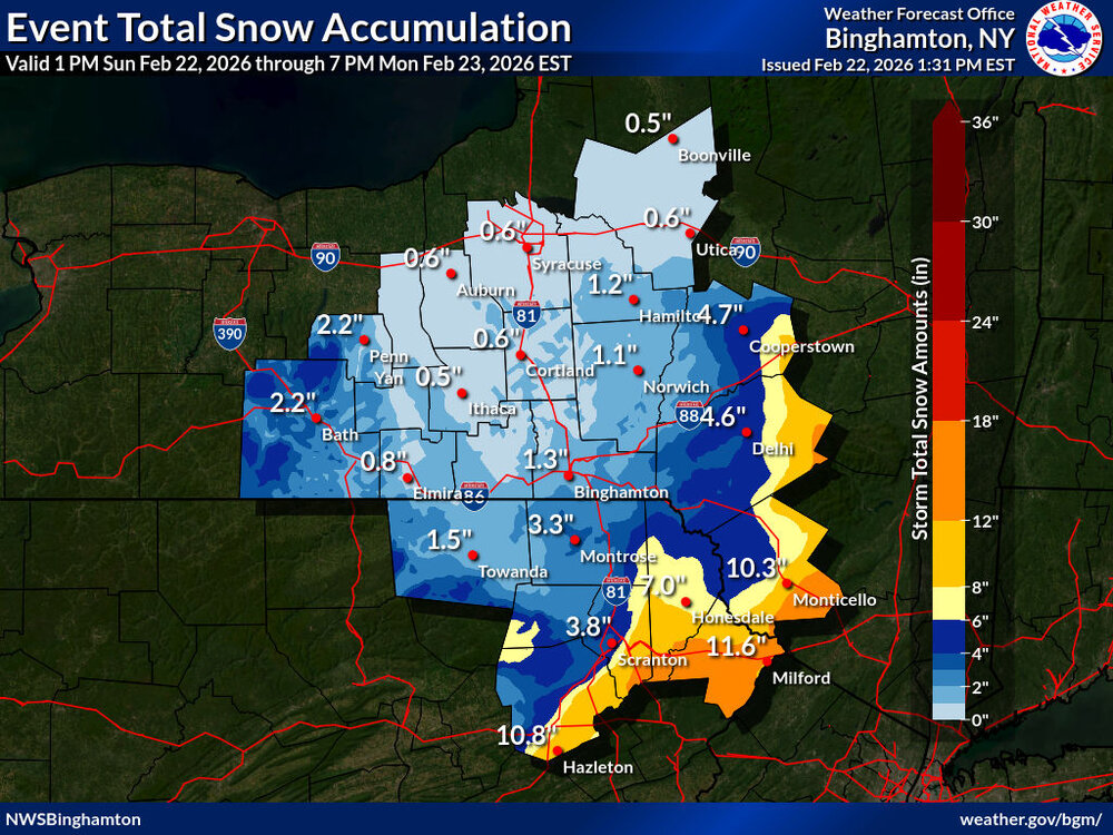
Schodack meso site up to 9.19” and still falling rather impressively up there.
-
North Branch meso site recorded 5.26” 24hr. Liberty had a local state of emergency. I was in town but nowhere close to where flooding was taking place.
-
Otisville meso station recorded 8.09” for the past 24hr. Closest station to me in Sullivan south recorded 2.81”, north 0.62”. My totals are probably closer to 2-3”. Probably like the third or fourth time in the past half a dozen years I just barely avoid a substantial rainfall event to the north. edit: Otisville meso station is 25 miles from Eldred meso. It was close.
-
87/74 at 9:55. Outpacing yesterday by almost exactly one hour
-
94/76 at home, 93/72 at MSV, 89/73 at work. I wonder which of these three makes the run at 100 tomorrow?
-
77/69. MSV’s record high for the day is 94, so probably going to make a run at the first of many records to fall over the next few days.
-
This would be some serious heat if it came to pass. My point and click has 99 as the high for Thursday
-
People on main thread arguing over 300 hour models…save me. there’s a reason you wait for 120 hours. In any case we’re almost certainly not done with winter yet; recent years have seen cold stretches get as deep into spring as early May. A nice moderate snowstorm to cap it all off would be lovely. Something like April 2018 with 5-6” that evaporated by early afternoon.
-
59/50. All of the snow is effectively gone. I would hedge my bets on one more decent storm before all breaks. If not, I finish right at the 45-50” mark for the season.
-
Up to 2-3’ of new snows meeting a warmup and rains is never good…
-
Staggering—parts of RI/MA collecting nearly 3’ out of this one.
-
Looks like widespread 2-3 across Sullivan should do it. More stunning is the fact that the roads looked like nothing happened whatsoever the whole way into work this morning.
-
2-3”, if that. More glad not much wind to speak of + have power right now
-
Definitely starting to see the breeze picking up slightly. No longer sure what to expect in western Sullivan, but 6” would still be decent. More glad that these trends mean I avoid the heavier amounts with the wind. I like having power.
-
Latest point/click downgrades my totals but upgraded to blizzard warning. 4-6 to 12-18 in 30-40 miles?