

Torch Tiger
-
Posts
10,157 -
Joined
-
Last visited
Content Type
Profiles
Blogs
Forums
American Weather
Media Demo
Store
Gallery
Posts posted by Torch Tiger
-
-
Ukie is very tucked, sucks for most of SNE
-
Thursday 04 7:45 A 9.44That's for Scituate Harbor...should be a fun high tide in the AM for E MA
-
Was in Norwell/Scituate today, huge ponds of standing water and sump pumps bumpin'. What a storm! Hopefully next one is the proverbial straw!
-
 1
1
-
 2
2
-
 1
1
-
-
6 minutes ago, dryslot said:
Kind of glad many think this way or we would be the new CT.
Congrats for the epic Spring snows (and a bit of rain). Many are jealous
-
Heck yeah! A big "hugger/transfer" type deal, at least on the gfs. As-is, take.
-
1
-
1
-
-
QPF...it's like anti-stein vaccine...a drug, I'm already fixing for more
-
15 minutes ago, MJO812 said:
This is also going to hit areas in SNE. Impressive blocking will shunt this south
Generally, there are many fantasy modeling heavy-hitters outside of D3-4? that end up being sputtering rain/globs that amount to nothing. Especially below 1 or even 1.5k later April
-
1
-
-
25 minutes ago, Lava Rock said:
Thanks kev
Sent from my SM-G981U1 using Tapatalk
He made it old hat, was already around lol
-
1
-
-
This is a great pattern. Hopefully some TORRENTIAL rains coming late month/May with increased pwats
-
 1
1
-
1
-
 2
2
-
3
-
-
Raines to Maines
-
1
-
-
let's flood!
-
1
-
-
he on the lookout
-
2
-
-
13 minutes ago, Damage In Tolland said:
Snowy Friday morning shaping up hills
-
3
-
1
-
-
sweet!
-
4 minutes ago, kdxken said:
S***'s getting weird. Snow storms, flood warnings and now black squirrels.
.thumb.jpg.20c733429d607b6f3c4aab071201dcd5.jpg)
I saw one of those last week. Lol
-
1
-
-
Nice day, rocketing through the 50's with even a little, dare I say, dew
-
2
-
-
5 hours ago, Prismshine Productions said:
Starts at hr180 and goes through hr216...

Sent from my SM-S146VL using Tapatalk
Can always adjust up
-
1
-
3
-
1
-
-
18z gfs would be amazing! Let's do that!!
-
1
-
-
Onto Napril
-
2 hours ago, dryslot said:
I'm looking for rain this time, Didn't need the snow/sleet this past weekend.
I hope you get 6" melted QPF no matter type
-
1
-
-
18z gfs seems like a reasonable middle-ground

-
5 minutes ago, Damage In Tolland said:
Drying out Friday . At least mention rain and heavy snow
you mean P/C forecast?
-
Was in RI today, Scituate/Smithfield was a RIVER coming down from those hills. Sides of roads washed out. Hopefully we can maximize the QPF on this next event to renew the excitement!
-
1 minute ago, Damage In Tolland said:
BOX has no mention of anything Friday. Just have a sunny, dry day after rain Wed night / Thursday. Almost like they just tossed everything except op Euro . Not even a precip or rain mention lol
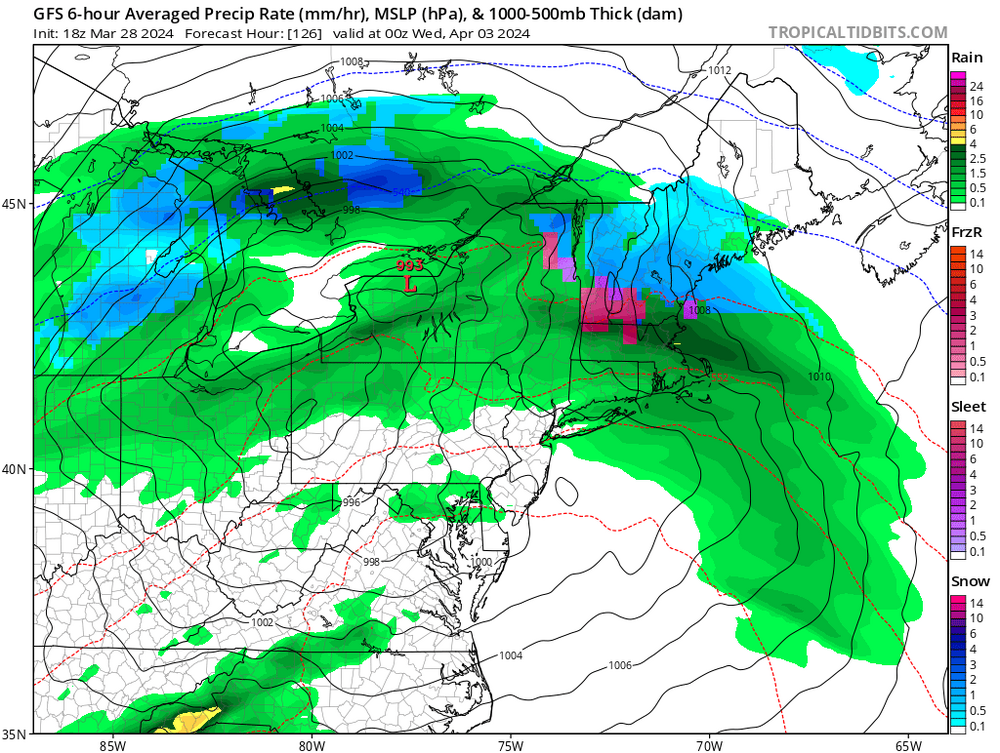
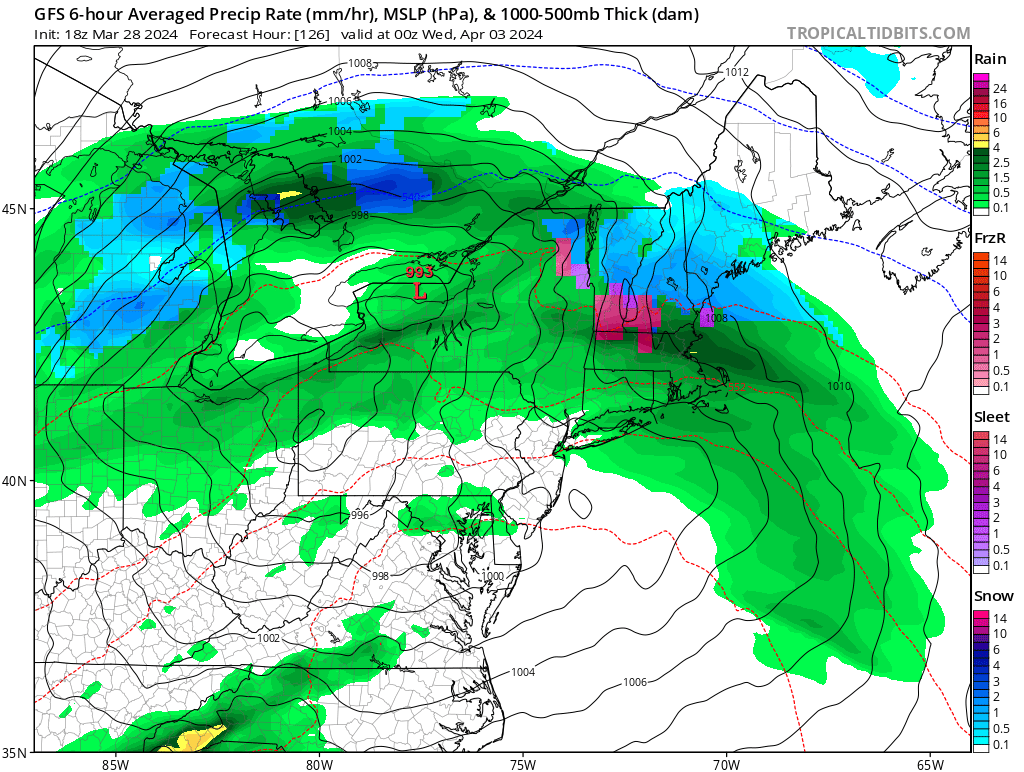
The focus period for the long term forecast will be Wednesday night
through Thursday night (at least). This 24-36 hour period has the
potential to deliver another round of 2-3 inches of rain to the
region which (I`m sure we don`t need to remind you) only recently
received this much rain and continues to see some rivers in flood
stage. The most important thing to determining where/if we deal with
exacerbated flooding will be the ultimate track of the storm and the
axis of heaviest rainfall. It is too soon to have a high degree of
confidence on where this axis sets up, but the most recent ECMWF
global guidance has come west, in line with the GFS/Canadian
guidance showing those large rainfall amounts over interior southern
New England rather than further east/offshore. Of course, we don`t
want to focus on deterministic model runs, but that agreement isn`t
what you would want to see if you`re hoping for a miss offshore. At
this time frame we focus on ensembles, two of which (the GEFS and
EPS) are indicating a 20-40% and 10-30% chance of AOA 2 inches of
rain respectively. Not huge numbers, but 3 days out certainly
indicative of potential for concern given how saturated the
ground is already. The atmospheric moisture and dynamics are
there, with a 1.25" PWAT plume directly from the Gulf of Mexico
and large scale ascent from favorable placement beneath a 150 kt
upper jet, but just how/if the northern and southern streams
interact is unknown at this time. Additionally, probabilistic
hydrographs from the NAEFS and GEFS indicate renewed flooding
for RI rivers. This system will also bring a period of gusty
winds as it passes late week.
.jpg.9d802a1dff7d4e3c9131495dee9cac35.jpg)
Significant Miller B Nor'easter watch, Apr 3rd-4th
in New England
Posted
Ha I guess