
.gif.a8150e126cebc480193fad2934fe975c.gif)
Torch Tiger
-
Posts
16,399 -
Joined
-
Last visited


-
.thumb.gif.f92b16c631a1d15d405ed77b33f0710d.gif)
Augdewst 2026: Summer's Last Stand
Torch Tiger replied to Prismshine Productions's topic in New England
Hopefully a widespread 1"+ for all -
Augdewst 2026: Summer's Last Stand
Torch Tiger replied to Prismshine Productions's topic in New England
The lines are drawn -
Augdewst 2026: Summer's Last Stand
Torch Tiger replied to Prismshine Productions's topic in New England
Soaker tomorrow? -
Augdewst 2026: Summer's Last Stand
Torch Tiger replied to Prismshine Productions's topic in New England
Great but what's this got to do with @CoastalWx? -
Augdewst 2026: Summer's Last Stand
Torch Tiger replied to Prismshine Productions's topic in New England
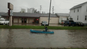
windshield rocked by a green 'ac a few hours ago. No damage -
Augdewst 2026: Summer's Last Stand
Torch Tiger replied to Prismshine Productions's topic in New England
Wow lookee there, and they said cool and dry -
3 drops.
-
Augdewst 2026: Summer's Last Stand
Torch Tiger replied to Prismshine Productions's topic in New England
Looks active for the first two weeks. Maybe some severe -
It was an amazing summer. Really looking forward to the extreme cold, snow that the winter of 2026-27 will bring! *
-
Yeah turned p sunny, a bit of a swampy dew day
-
Augdewst 2026: Summer's Last Stand
Torch Tiger replied to Prismshine Productions's topic in New England
they're in desperation mode Ya love to see it -
you DID win?
-
eh, a few sprinkles/light showers
-
let's get after it!
-
maybe it'll curve in - way, in, like early Andrew in


